

Oreti River
Encyclopedia
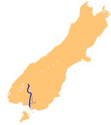
The Oreti has its headwaters close to the Mavora Lakes
Mavora Lakes
The Mavora Lakes are located in the South Island of New Zealand.They consist of two lakes named North Mavora and South Mavora. The area has rudimentary camping sites and is maintained by the Department of Conservation. This park was also used as a film location for the Lord of the Rings movie...
between Lake Te Anau
Lake Te Anau
Lake Te Anau is in the southwestern corner of the South Island of New Zealand. Its name was originally Te Ana-au, Maori for 'The cave of swirling water'. The lake covers an area of 344 km², making it the second-largest lake by surface area in New Zealand and the largest in the South Island...
and Lake Wakatipu
Lake Wakatipu
Lake Wakatipu is an inland lake in the South Island of New Zealand. It is in the southwest corner of Otago Region, near its boundary with Southland.With a length of , it is New Zealand's longest lake, and, at , its third largest...
, and flows south across the Southland Plains
Southland Plains
The Southland Plains is a general name given to several areas of low-lying land in the South Island of New Zealand, separated by the rise of the Hokonui Hills in the north. It forms a sizeable area of Southland Region and encompasses its two principal settlements the city of Invercargill and the...
to its outflow into Foveaux Strait
Foveaux Strait
Foveaux Strait separates Stewart Island/Rakiura, New Zealand's third largest island, from the South Island. Three large bays, Te Waewae Bay, Oreti Beach and Toetoes Bay, sweep along the strait's northern coast, which also hosts Bluff township and harbour. Across the strait lie the Solander...
at the southeastern end of Oreti Beach
Oreti Beach
Oreti Beach is the central bay of three lying on the Foveaux Strait coast of Southland, New Zealand, the others being Te Waewae Bay and Toetoes Bay...
. En route, it runs through the towns of Lumsden
Lumsden, New Zealand
Lumsden is a town in Southland, New Zealand. Lying in a gap in the surrounding hills, it is the location of a major junction halfway along the north-south road from Queenstown to Invercargill, where it is crossed by the east-west road from Gore to Te Anau. The town had a population of 453 as of the...
and Winton
Winton, New Zealand
Winton is a town in Southland, New Zealand. It is located close to the east bank of the Oreti River, 30 kilometres north of Invercargill and 50 kilometres south of Lumsden. It is named after Thomas Winton, a local stockman who lived in the area in the 1850s...
, before passing through the city of Invercargill
Invercargill
Invercargill is the southernmost and westernmost city in New Zealand, and one of the southernmost cities in the world. It is the commercial centre of the Southland region. It lies in the heart of the wide expanse of the Southland Plains on the Oreti or New River some 18 km north of Bluff,...
, close to the river's estuary
Estuary
An estuary is a partly enclosed coastal body of water with one or more rivers or streams flowing into it, and with a free connection to the open sea....
.
For the final part of the river's length, around the city of Invercargill and the river's estuary just south of the city, it is known as the New River, a name occasionally encountered to refer to the whole river.