

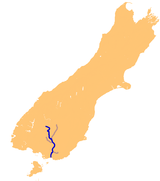
Mataura River
Encyclopedia
Southland Region
Southland is New Zealand's southernmost region and is also a district within that region. It consists mainly of the southwestern portion of the South Island and Stewart Island / Rakiura...
of the South Island
South Island
The South Island is the larger of the two major islands of New Zealand, the other being the more populous North Island. It is bordered to the north by Cook Strait, to the west by the Tasman Sea, to the south and east by the Pacific Ocean...
of New Zealand
New Zealand
New Zealand is an island country in the south-western Pacific Ocean comprising two main landmasses and numerous smaller islands. The country is situated some east of Australia across the Tasman Sea, and roughly south of the Pacific island nations of New Caledonia, Fiji, and Tonga...
. It is 190 kilometres in length.
The river's headwaters are located in mountains to the south of Lake Wakatipu
Lake Wakatipu
Lake Wakatipu is an inland lake in the South Island of New Zealand. It is in the southwest corner of Otago Region, near its boundary with Southland.With a length of , it is New Zealand's longest lake, and, at , its third largest...
. From there it flows southeast towards Gore
Gore, New Zealand
Gore is a town, surrounding borough, and district in the Southland region of the South Island of New Zealand.-Geography:The Gore District has a land area of 1,251.62 km² and a resident population of...
, where it turns southward. It then passes through the town of Mataura
Mataura
Mataura is a town in the Southland region of the South Island of New Zealand. Mataura has a meat processing plant, and until 2000 it was the site of a large pulp and paper mill....
, and enters the Pacific Ocean
Pacific Ocean
The Pacific Ocean is the largest of the Earth's oceanic divisions. It extends from the Arctic in the north to the Southern Ocean in the south, bounded by Asia and Australia in the west, and the Americas in the east.At 165.2 million square kilometres in area, this largest division of the World...
at Toetoes Bay
Toetoes Bay
Toetoes Bay is the easternmost of three large bays lying on the Foveaux Strait coast of Southland, New Zealand, the others being Te Waewae Bay and Oreti Beach. Thirty kilometres in length, the bay is the southern end of the Awarua Plain, an area of swampy land stretching inland for about fifteen...
on the southern coast of the South Island.
The name comes from the Māori
Maori language
Māori or te reo Māori , commonly te reo , is the language of the indigenous population of New Zealand, the Māori. It has the status of an official language in New Zealand...
words mata ('red') and ura ('eddying'). The red colouring of the water is caused by iron oxide
Iron oxide
Iron oxides are chemical compounds composed of iron and oxygen. All together, there are sixteen known iron oxides and oxyhydroxides.Iron oxides and oxide-hydroxides are widespread in nature, play an important role in many geological and biological processes, and are widely utilized by humans, e.g.,...
s in the local swamps.
The Mataura is renowned as a source of brown trout
Brown trout
The brown trout and the sea trout are fish of the same species....
, and is a popular fishing
Fishing
Fishing is the activity of trying to catch wild fish. Fish are normally caught in the wild. Techniques for catching fish include hand gathering, spearing, netting, angling and trapping....
venue.
The Mataura, along with the three other main Southland rivers, the Waiau
Waiau River, Southland
Waiau River is the largest river in the Southland Region of New Zealand. It is the outflow of Lake Te Anau, flowing from it into Lake Manapouri 10 kilometres to the south, and from there flows south for 70 kilometres before reaching the Foveaux Strait eight kilometres south of Tuatapere...
, Oreti
Oreti River
The Oreti River is one of the main rivers of Southland, New Zealand, and is 170 kilometres in length.The Oreti has its headwaters close to the Mavora Lakes between Lake Te Anau and Lake Wakatipu, and flows south across the Southland Plains to its outflow into Foveaux Strait at the southeastern end...
and Aparima
Aparima River
The Aparima River is located in Southland, New Zealand. It has its headwaters in the Takitimu Mountains, south of Lake Te Anau, and flows south for 100 kilometres before entering Foveaux Strait near Riverton at the north end of Oreti Beach....
, breached during the Southland floods of January, 1984. Commercial and residential areas of the town of Mataura
Mataura
Mataura is a town in the Southland region of the South Island of New Zealand. Mataura has a meat processing plant, and until 2000 it was the site of a large pulp and paper mill....
were particularly affected, including the pulp and paper plant.