

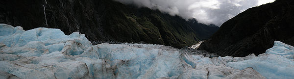
Franz Josef Glacier
Encyclopedia

Glacier
A glacier is a large persistent body of ice that forms where the accumulation of snow exceeds its ablation over many years, often centuries. At least 0.1 km² in area and 50 m thick, but often much larger, a glacier slowly deforms and flows due to stresses induced by its weight...
located in Westland Tai Poutini National Park on the West Coast of New Zealand
New Zealand
New Zealand is an island country in the south-western Pacific Ocean comprising two main landmasses and numerous smaller islands. The country is situated some east of Australia across the Tasman Sea, and roughly south of the Pacific island nations of New Caledonia, Fiji, and Tonga...
's South Island
South Island
The South Island is the larger of the two major islands of New Zealand, the other being the more populous North Island. It is bordered to the north by Cook Strait, to the west by the Tasman Sea, to the south and east by the Pacific Ocean...
. Together with the Fox Glacier
Fox Glacier
The Fox Glacier is a long glacier located in Westland Tai Poutini National Park on the West Coast of New Zealand's South Island...
20 km (12.4 mi) to the south, it is unique in descending from the Southern Alps
Southern Alps
The Southern Alps is a mountain range extending along much of the length of New Zealand's South Island, reaching its greatest elevations near the island's western side...
to less than 300 metres (984.3 ft) above sea level, amidst the greenery and lushness of a temperate rainforest.
The area surrounding the two glaciers is part of Te Wahipounamu
Te Wahipounamu
Te Wāhipounamu is a World Heritage site in the south west corner of the South Island of New Zealand.Inscribed on the World Heritage List in 1990 and covering 26,000 km², the site incorporates several National Parks:...
, a World Heritage Site
World Heritage Site
A UNESCO World Heritage Site is a place that is listed by the UNESCO as of special cultural or physical significance...
park. The river emerging from the glacier terminal of Franz Josef is known as the Waiho River
Waiho River
The Waiho River is a river of the West Coast Region of New Zealand's South Island. It is fed by the meltwater of the Franz Josef Glacier and flows through the township of Franz Josef to reach the Tasman Sea coast 10 kilometres southwest of Okarito....
.
Naming
The first European mention of one of the western-coast glaciers, believed to be Franz Josef, was from the steam ship Mary Louisa in 1859. The glacier was later named after Emperor Franz Joseph I of AustriaFranz Joseph I of Austria
Franz Joseph I or Francis Joseph I was Emperor of Austria, King of Bohemia, King of Croatia, Apostolic King of Hungary, King of Galicia and Lodomeria and Grand Duke of Cracow from 1848 until his death in 1916.In the December of 1848, Emperor Ferdinand I of Austria abdicated the throne as part of...
by the German explorer, Julius von Haast
Julius von Haast
Sir Johann Franz "Julius" von Haast was a German geologist. He founded Canterbury Museum at Christchurch.-Biography:...
in 1865. The Māori name for the glacier is Ka Roimata o Hinehukatere ('The tears of Hinehukatere'), arising from a local legend: Hinehukatere loved climbing in the mountains and persuaded her lover, Wawe, to climb with her. Wawe was a less experienced climber than Hinehukatere but loved to accompany her until an avalanche
Avalanche
An avalanche is a sudden rapid flow of snow down a slope, occurring when either natural triggers or human activity causes a critical escalating transition from the slow equilibrium evolution of the snow pack. Typically occurring in mountainous terrain, an avalanche can mix air and water with the...
swept Wawe from the peaks to his death. Hinehukatere was broken hearted and her many, many tears flowed down the mountain and froze to form the glacier.
Advance and retreat
The glacier is currently 12 km (7.5 mi) long and terminates 19 km (11.8 mi) from the Tasman SeaTasman Sea
The Tasman Sea is the large body of water between Australia and New Zealand, approximately across. It extends 2,800 km from north to south. It is a south-western segment of the South Pacific Ocean. The sea was named after the Dutch explorer Abel Janszoon Tasman, the first recorded European...
. Fed by a 20 square kilometres (7.7 sq mi) large snowfield at high altitude, it exhibits a cyclic pattern of advance and retreat, driven by differences between the volume of meltwater at the foot of the glacier and volume of snowfall feeding the névé
Névé
Névé is a young, granular type of snow which has been partially melted, refrozen and compacted, yet precedes the form of ice. This type of snow is associated with glacier formation through the process of nivation. Névé that survives a full season of ablation is referred to as firn, which is both...
. Due to strong snowfall it is one of the few glaciers in New Zealand which was still growing as of 2007, by mid 2010 this advance had ended and the glacier is currently in a state of retreat. Others, mostly on the eastern side of the Southern Alps
Southern Alps
The Southern Alps is a mountain range extending along much of the length of New Zealand's South Island, reaching its greatest elevations near the island's western side...
, have been shrinking heavily, a process attributed to global warming
Global warming
Global warming refers to the rising average temperature of Earth's atmosphere and oceans and its projected continuation. In the last 100 years, Earth's average surface temperature increased by about with about two thirds of the increase occurring over just the last three decades...
.
Having retreated several kilometres between the 1940s and 1980s, the glacier entered an advancing phase in 1984 and at times has advanced at the phenomenal (by glacial standards) rate of 70 cm a day. The flow rate is about 10 times that of typical glaciers. Over the longer term, the glacier has retreated since the last ice age
Ice age
An ice age or, more precisely, glacial age, is a generic geological period of long-term reduction in the temperature of the Earth's surface and atmosphere, resulting in the presence or expansion of continental ice sheets, polar ice sheets and alpine glaciers...
, and it is believed that it extended into the sea some 10,000 to 15,000 years ago.
This cyclic behaviour is well illustrated by a postage stamp issued in 1946, depicting the view from St James Anglican Church. The church was built in 1931, with a panoramic altar window to take advantage of its location. By 1954, the glacier had disappeared from view from the church, but it reappeared in 1997. This is due to the highly variable conditions on the snowfield, which take around 5-6 years before they result in changes in the terminus location.
There have been some incidents of jökulhlaups
Glacial lake outburst flood
A glacial lake outburst flood is a type of outburst flood that occurs when the dam containing a glacial lake fails. The dam can consist of glacier ice or a terminal moraine...
(outbreak floods from water-filled ice tunnels) at the glacier, with one destroying a bridge on the access route in 1989.
Based on past variations, scientists expect that Franz Josef Glacier will retreat 5 km and lose 38% of its mass by 2100 in a mid-range scenario of warming.
Tourism
The glacier area is one of the main tourist attractions of the West CoastWest Coast, New Zealand
The West Coast is one of the administrative regions of New Zealand, located on the west coast of the South Island, and is one of the more remote and most sparsely populated areas of the country. It is made up of three districts: Buller, Grey and Westland...
, with around 250,000 visitors a year, and up to 2,700 per day (2007). Guided and unguided walks up to and onto the glacier are possible. The latter require some specialised equipment, namely ice axe
Ice axe
An ice axe, is a multi-purpose ice and snow tool used by mountaineers both in the ascent and descent of routes which involve frozen conditions. It can be held and employed in a number of different ways, depending on the terrain encountered...
s and crampons
Crampons
Crampons are traction devices used to improve mobility on snow and ice. There are three main attachment systems for footwear: step-in, hybrid, and strap bindings. The first two require boots with welts, the last adapt to any type....
that latch onto a sturdy boot.
As the walking part of any tour up to the glacier takes a long time, and ends at the first icefall
Icefall
An icefall is a portion of some glaciers characterized by rapid flow and a chaotic crevassed surface. Perhaps the most conspicuous consequence of glacier flow, icefalls occur where the glacier bed steepens and/or narrows...
(a sort of frozen waterfall, showing a natural dip of the land underneath), numerous tourists book helicopter
Helicopter
A helicopter is a type of rotorcraft in which lift and thrust are supplied by one or more engine-driven rotors. This allows the helicopter to take off and land vertically, to hover, and to fly forwards, backwards, and laterally...
tours from one of the several local airlines, which usually drop their guests between the first and second icefall, for a guided 1-2 hour walk through the broken ground atop the glacier. Though the glacial landscape changes almost daily with the glaciers unusually fast flow, and some walks include passages through ice tunnels, they are still considered quite safe and only somewhat strenuous.
Franz Josef township is a little service village (approximately 330 inhabitants) located approximately 5 km away from the face of the glacier on State Highway 6. It has a small but busy heliport, numerous tourist accommodation options (with up to 2,000 people staying overnight during the main season) and a number of restaurants and shops.
In June 2010, an Australian tourist died during a guided hike of the glacier.
See also
- Climate change in New ZealandClimate change in New ZealandClimate change in New Zealand, in the sense of anthropogenic global warming during the 20th century, is apparent in the instrumental record, in New Zealand's participation in international treaties and in social and political debates. Climate change is being responded to in a variety of ways by...
- Glacial retreat since 1850Retreat of glaciers since 1850The retreat of glaciers since 1850 affects the availability of fresh water for irrigation and domestic use, mountain recreation, animals and plants that depend on glacier-melt, and in the longer term, the level of the oceans...
- Fox GlacierFox GlacierThe Fox Glacier is a long glacier located in Westland Tai Poutini National Park on the West Coast of New Zealand's South Island...
- Glaciers of New ZealandGlaciers of New ZealandNew Zealand contains many glaciers, mostly located near the Main Divide of the Southern Alps in the South Island.An inventory of South Island glaciers during the 1980s indicated there were about 3,155 glaciers with an area of at least one hectare . Approximately one sixth of these glaciers covered...
- List of glaciers
External links
- Franz Josef area at the Department of ConservationNew Zealand Department of ConservationThe Department of Conservation , commonly known by its acronym, "DOC", is the state sector organisation which deals with the conservation of New Zealand’s natural and historic heritage...
- West Coast & Glaciers at New Zealand Tourism
- Glaciers of New Zealand at the United States Geological SurveyUnited States Geological SurveyThe United States Geological Survey is a scientific agency of the United States government. The scientists of the USGS study the landscape of the United States, its natural resources, and the natural hazards that threaten it. The organization has four major science disciplines, concerning biology,...