

Saint Arnaud, New Zealand
Encyclopedia
New Zealand
New Zealand is an island country in the south-western Pacific Ocean comprising two main landmasses and numerous smaller islands. The country is situated some east of Australia across the Tasman Sea, and roughly south of the Pacific island nations of New Caledonia, Fiji, and Tonga...
's South Island
South Island
The South Island is the larger of the two major islands of New Zealand, the other being the more populous North Island. It is bordered to the north by Cook Strait, to the west by the Tasman Sea, to the south and east by the Pacific Ocean...
, west of the mountains of the Saint Arnaud Range
Saint Arnaud Range
The Saint Arnaud Range is a mountain range in the central north of New Zealand's South Island. It lies between Lake Rotoiti and the upper reaches of the Wairau River, and marks the eastern boundary of Nelson Lakes National Park....
and 90 kilometres southwest of Nelson
Nelson, New Zealand
Nelson is a city on the eastern shores of Tasman Bay, and is the economic and cultural centre of the Nelson-Tasman region. Established in 1841, it is the second oldest settled city in New Zealand and the oldest in the South Island....
near the historic Tophouse Settlement
Tophouse
Tophouse, also known as Tophouse Settlement, is a rural locality in the Tasman District of New Zealand's South Island, some 8 km northeast of Saint Arnaud. It is named after a hotel established in the 19th century to service drovers transporting their sheep between Canterbury and Marlborough...
. It is situated at the northern end of Lake Rotoiti.
Name dispute
The village had been called Rotoiti until 1921, when it was re-named by the Department of Lands and Survey to avoid confusion with other communities of the same name. Archives show that between 1921 and 1951 both names were unofficially used by local residents and government agencies when referring to the village area.Such references include a letter dated 1 June 1950 from the Chief Surveyor of the Nelson District Office of the Department of Lands and Survey to the New Zealand Geographic Board stating that "for many years confusion has occurred due to correspondence addressed to the residents and visitors at Lake Rotoiti in the Nelson Land District going to Lake Rotoiti, near Rotorua, in the Auckland Land District. Due to the same confusion of names, the Town of Rotoiti in the Nelson Land District was altered to Town of St. Arnaud by this Department." However, the name St. Arnaud did not receive legal approval until it was gazetted on 19 July 1951. Some locals were opposed to this change, as shown by a 4 December 1950 petition held by the New Zealand Geographic Board opposing the name change. Some local residents today still give their address as Lake Rotoiti, even with St. Arnaud as the official name.
A proposal with the New Zealand Geographic Board
New Zealand Geographic Board
The New Zealand Geographic Board is constituted under the New Zealand Geographic Board Act 2008, formerly under the New Zealand Geographic Board Act 1946. Although an independent institution, it is responsible to the Minister for Land Information...
to either change the village's name back to its original name of Rotoiti or to use a dual name (a relatively common practice in New Zealand), failed in 2007. A survey had originally indicated that just over half of the area residents supported a return to the original name.
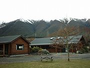
Facilities
Mostly catering for a small number of locals and the tramping and skiing tourists, the centre of Saint Arnaud has a village store with postal services, a petrol station, a cafe-restaurant, camping facilities, motels, chalets and specialist accommodation for trampers at the Yellow House youth hostel. A water taxi service operates from a jetty at the northern end of Lake Rotoiti, near to a DOC campsite at Kerr Bay. There is another campsite at West Bay. A daily shuttle bus service along State Highway 63New Zealand State Highway 63
State Highway 63 is a New Zealand State Highway located in the northern parts of the South Island of New Zealand. It is 117 km long and runs between the settlements of Renwick and Kawatiri Junction via Saint Arnaud, providing a bypass of the city of Nelson.-Route:SH 63 begins just to the...
provides connections to Nelson
Nelson, New Zealand
Nelson is a city on the eastern shores of Tasman Bay, and is the economic and cultural centre of the Nelson-Tasman region. Established in 1841, it is the second oldest settled city in New Zealand and the oldest in the South Island....
, Murchison
Murchison, New Zealand
Murchison is a town in the Tasman Region of the South Island of New Zealand. It is near the western end of the "Four Rivers Plain", at the confluence of the Buller River and the Matakitaki River...
, Greymouth
Greymouth
Greymouth is the largest town in the West Coast region in the South Island of New Zealand, and the seat of the Grey District Council. The population of the whole Grey District is , which accounts for % of the West Coast's inhabitants...
, Blenheim
Blenheim, New Zealand
Blenheim is the most populous town in the region of Marlborough, in the north east of the South Island of New Zealand, and the seat of the regional council. It has a population of The area which surrounds the town is well known as a centre of New Zealand's wine industry...
, Westport
Westport, New Zealand
-Economy:Economic activity is based around fishing, coal mining and dairy farming. Historically, gold mining was a major industry, and coal mining was much more extensive than today . However, the region still is home to New Zealand's largest opencast mining operation in Stockton...
and Picton
Picton, New Zealand
Picton is a town in the Marlborough region of New Zealand. It is close to the head of Queen Charlotte Sound near the north-east corner of the South Island. The population was 2928 in the 2006 Census, a decrease of 72 from 2001...
.
The Royal New Zealand Air Force
Royal New Zealand Air Force
The Royal New Zealand Air Force is the air arm of the New Zealand Defence Force...
's field training base is nearby at Dip Flat
RNZAF Dip Flat
RNZAF Dip Flat is the field training facility of the Royal New Zealand Air Force.Located at the base of the Saint Arnaud Range at the eastern boundary of Nelson Lakes National Park in the South Island of New Zealand, Dip Flat serves to train recruits from CRTS in "out-in-the-field" practical...
.
Nelson Lakes National Park
The western part of the township includes a local Department of ConservationNew Zealand Department of Conservation
The Department of Conservation , commonly known by its acronym, "DOC", is the state sector organisation which deals with the conservation of New Zealand’s natural and historic heritage...
(DOC) Visitor Centre, with interactive displays and comprehensive information about the wildlife and environmental management of the Nelson Lakes National Park. The Centre has a team of professional staff who can offer detailed advice and guidance about all aspects of the area. A number of local footpaths, tracks and nature trails, suitable for all abilities, are maintained by the Department.
Saint Arnaud is a starting point for the strenuous 80 km Travers - Sabine tramping circuit. This follows the valley of the Travers River
Travers River
The Travers River is in the South Island of New Zealand.It lies within the borders of the Nelson Lakes National Park. The valley through which the river flows is popular with trampers and is part of the Travers-Sabine tramping circuit, which follows a major portion of the river, starting from Kerr...
, ascends over the sub-alpine Travers Saddle, the watershed
Water divide
A drainage divide, water divide, divide or watershed is the line separating neighbouring drainage basins...
, and then descends the Sabine River
Sabine River, New Zealand
thumb|right|200px|View up the Sabine Valley.The Sabine River is in the South Island of New Zealand. It is located in Nelson Lakes National Park....
valley and gorge to Lake Rotoroa. From here walkers can complete the circuit back to Saint Arnaud by either crossing a low saddle to the valley of Lake Rotoiti, via the Speargrass Track, or by ascending a higher route via Mount Angelus. Alternatively, they can take a water taxi from the DOC Sabine Hut on Lake Rotoroa
Lake Rotoroa
Lake Rotoroa lies within the borders of Nelson Lakes National Park in the South Island, New Zealand. The lake is fed by the D'Urville and Sabine rivers....
up to the northern end of the lake.
In winter, snow sports take place primarily at Rainbow Skifield on the eastern side of the Saint Arnaud Range. Other local recreational activities include fishing, hunting, kayaking, small boat sailing, and gliding.
Further reading
- Darroch Donald (2003) Footprint Guide to New Zealand, 2nd Edition, pp 481–483
- Jim Dufresne (2002) Tramping in New Zealand, 5th Edition, Lonely Planet Books