
New Zealand State Highway 8
Encyclopedia
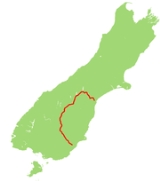
State Highway 8 is one of New Zealand
's eight national highways
. It forms an anticlockwise loop through the southern scenic regions of the Mackenzie Basin
and Central Otago
, starting and terminating in junctions with State Highway 1
. Distances are measured from north to south.
For most of its length SH8 is a two-lane single carriageway
, with at-grade intersections and property accesses directly off the road, both in rural and urban areas.
The highway leaves SH1 at Washdyke
, an industrial suburb of Timaru
, travelling initially northwest towards the town of Fairlie
. From here the route tends westward and rapidly increases in altitude, passing the southern end of the two great Mackenzie Basin lakes of Tekapo
and Pukaki
.
From Pukaki the highway turns southwest across the upper reaches of the Waitaki Valley
, passing through the former hydroelectricity
service town of Twizel
and Omarama
before again climbing to cross the Lindis Pass
, which, at 971 metres, is the highest point on the highway's path. The highway winds along the valley of the Lindis River
, reaching the upper Clutha River
not far from Tarras
.
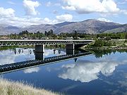
From here, the highway runs close to the eastern shore of the man-made Lake Dunstan
before passing the historic town of Cromwell
. The highway turns south as it travels through the Cromwell Gorge
passing the country's largest hydroelectric dam, the Clyde Dam
at Clyde
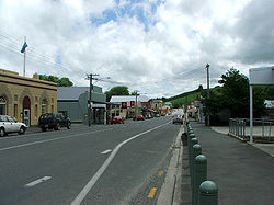
. The highway continues along the Clutha Valley through the town of Alexandra
and past Lake Roxburgh
to the town of Roxburgh
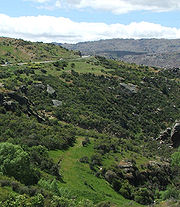
. Much of this part of the highway's journey is past fruit orchards, and historic gold-diggings from the Central Otago Gold Rush
.
From Roxburgh, the highway turns southeastward, passing Ettrick
, Raes Junction
and Beaumont
, where it turns away from the Clutha, before reaching Lawrence
, close to the original strike in the Central Otago Gold Rush. From here, the highway continues past Waitahuna
and the twisting Manuka Gorge, reaching the plain of the Tokomairiro River
at Clarksville
, three kilometres south of Milton
.
 State Highway 8 has two spurs: State Highway 8A and State Highway 8B. These two spurs connect the highway with State Highway 6, which lies on the western bank of Lake Dunstan
. State Highway 8A runs for 23 km from SH6 at Luggate to connect with SH8 close to Tarras
. State Highway 8B runs for just 2.6 km from SH8 at Deadmans Point across the lake to the town of Cromwell
.
, which flooded much of the Cromwell Gorge
, including the former route of the highway. A completely new section was built between Clyde and Cromwell; for SH8B the old single-lane bridge crossing the Clutha was replaced with a new two-lane bridge approximately 1.5 km to the north.
New Zealand
New Zealand is an island country in the south-western Pacific Ocean comprising two main landmasses and numerous smaller islands. The country is situated some east of Australia across the Tasman Sea, and roughly south of the Pacific island nations of New Caledonia, Fiji, and Tonga...
's eight national highways
New Zealand State Highway network
The New Zealand State Highway network is the major national highway network in New Zealand. Just under 100 roads in both the North and South Islands are State Highways...
. It forms an anticlockwise loop through the southern scenic regions of the Mackenzie Basin
Mackenzie Basin
The Mackenzie Basin , is an elliptical intermontane basin, located in the Mackenzie and Waitaki Districts, near the centre of the South Island of New Zealand. It is the largest such basin in New Zealand...
and Central Otago
Central Otago
Central Otago is the inland part of the New Zealand region of Otago in the South Island. The area commonly known as Central Otago includes both the Central Otago District and the Queenstown-Lakes District to the west....
, starting and terminating in junctions with State Highway 1
State Highway 1 (New Zealand)
State Highway 1 is the longest and most significant road in the New Zealand roading network, running the length of both main islands. It appears on road maps as SH 1 and on road signs as a white number 1 on a red shield, but it has the official designations SH 1N in the North Island, SH 1S in the...
. Distances are measured from north to south.
For most of its length SH8 is a two-lane single carriageway
Single carriageway
A single carriageway is a road with 1, 2 or more lanes arranged within a single carriageway with no central reservation to separate opposing flows of traffic. Two-lane road or two-lane highway are single carriageway with one lane for each direction...
, with at-grade intersections and property accesses directly off the road, both in rural and urban areas.
Route
Main route
The State Highway 8 route (as of 2010):The highway leaves SH1 at Washdyke
Washdyke
Washdyke is an industrial suburb in the north of Timaru, in south Canterbury, New Zealand. State Highway 1 passes through Washdyke on the way north out of the city...
, an industrial suburb of Timaru
Timaru
TimaruUrban AreaPopulation:27,200Extent:Former Timaru City CouncilTerritorial AuthorityName:Timaru District CouncilPopulation:42,867 Land area:2,736.54 km² Mayor:Janie AnnearWebsite:...
, travelling initially northwest towards the town of Fairlie
Fairlie, New Zealand
FairlieUrban AreaPopulation:723Extent:Territorial AuthorityName:Mackenzie District CouncilPopulation:Mayor:Website:Extent:Regional councilName:Environment Canterbury...
. From here the route tends westward and rapidly increases in altitude, passing the southern end of the two great Mackenzie Basin lakes of Tekapo
Lake Tekapo
Lake Tekapo is the second-largest of three roughly parallel lakes running north–south along the northern edge of the Mackenzie Basin in the South Island of New Zealand...
and Pukaki
Lake Pukaki
Lake Pukaki is the largest of three roughly parallel alpine lakes running north-south along the northern edge of the Mackenzie Basin on New Zealand's South Island. The others are Lakes Tekapo and Ohau...
.
From Pukaki the highway turns southwest across the upper reaches of the Waitaki Valley
Waitaki River
The Waitaki River is a large river in the South Island of New Zealand, some 110 km long. It is the major river of the Mackenzie Basin.It is a braided river which flows through Lake Benmore, Lake Aviemore and Lake Waitaki. These are ultimately fed by three large glacial lakes, Pukaki, Tekapo,...
, passing through the former hydroelectricity
Hydroelectricity
Hydroelectricity is the term referring to electricity generated by hydropower; the production of electrical power through the use of the gravitational force of falling or flowing water. It is the most widely used form of renewable energy...
service town of Twizel
Twizel
TwizelUrban AreaPopulation:1,000Extent:Territorial AuthorityName:Mackenzie District CouncilPopulation:Mayor:Website:Extent:Regional councilName:Environment Canterbury...
and Omarama
Omarama
Omarama is a small township at the junction of State Highways 8 and 83, near the southern end of the Mackenzie Basin, in the South Island of New Zealand. Omarama is in the Waitaki District, in the historic Province of Otago...
before again climbing to cross the Lindis Pass
Lindis Pass
Lindis Pass is located in the South Island of New Zealand.It lies between the towns of Cromwell in Central Otago and Omarama in North Otago, on the main inland route to the Mackenzie Basin in Canterbury....
, which, at 971 metres, is the highest point on the highway's path. The highway winds along the valley of the Lindis River
Lindis River
The Lindis River is found in Otago in the South Island of New Zealand. It is a tributary of the Clutha River, flowing south for 55 kilometres through the Lindis Pass, site of the main inland road route between Otago and the Mackenzie Basin in Canterbury....
, reaching the upper Clutha River
Clutha River
The Clutha River / Mata-Au is the second longest river in New Zealand flowing south-southeast through Central and South Otago from Lake Wanaka in the Southern Alps to the Pacific Ocean, south west of Dunedin. It is the highest volume river in New Zealand, and the swiftest, with a catchment of ,...
not far from Tarras
Tarras
Tarras is a small farming settlement in Central Otago, in the South Island of New Zealand. It is located on the slopes above the upper reaches of the Clutha Valley, on State Highway 8 not far from the southern end of the Lindis Pass. Most farms in the Tarras district run sheep, principally merino...
.
From here, the highway runs close to the eastern shore of the man-made Lake Dunstan
Lake Dunstan
Lake Dunstan is a man-made lake and reservoir in the South Island of New Zealand.The lake was formed on the Clutha River as a result of the construction of the Clyde Dam, filling in four controlled stages beginning in April 1992 and completed the next year...
before passing the historic town of Cromwell
Cromwell, New Zealand
Cromwell is a town in Central Otago in the Otago region of New Zealand.It is situated between State Highway 6 and State Highway 8 leading to the Lindis Pass, 75 km northeast, and Alexandra, 33 km south. The road to Alexandra winds through the Cromwell Gorge...
. The highway turns south as it travels through the Cromwell Gorge
Cromwell Gorge
The Cromwell Gorge is a deep gorge on the Clutha River in the Otago region of New Zealand's South Island. It stretches for 20 km south of the town of Cromwell towards Alexandra....
passing the country's largest hydroelectric dam, the Clyde Dam
Clyde Dam
The Clyde Dam, New Zealand's third largest hydroelectric dam, is built on the Clutha River near the town of Clyde. It is owned and operated by Contact Energy.-History:...
at Clyde
Clyde, New Zealand
Clyde is a small town in Central Otago, New Zealand with a population of 918 in 2006. It is located on the Clutha River, between Cromwell and Alexandra....
. The highway continues along the Clutha Valley through the town of Alexandra
Alexandra, New Zealand
Alexandra is a town in the Central Otago district of the Otago region of New Zealand. It is located on the banks of the Clutha River , on State Highway 8, 188 km by road from Dunedin and 33 km south of Cromwell.At the time of the 2006 census, the permanent population was 4,827, an...
and past Lake Roxburgh
Lake Roxburgh
Lake Roxburgh is an artificial lake, created by the Roxburgh Dam, the earliest of the large hydroelectric projects in the southern South Island of New Zealand. It lies on the Clutha River, some 160 kilometres from Dunedin. It covers an area of some 6 km², and extends for nearly 30 kilometres...
to the town of Roxburgh
Roxburgh, New Zealand
Roxburgh is a small New Zealand town of about 600 people in Central Otago. It is in Teviot Valley on the banks of the Clutha River, 40 km south of Alexandra in the South Island. State Highway 8, which links Central Otago with Dunedin city, passes through the town...
. Much of this part of the highway's journey is past fruit orchards, and historic gold-diggings from the Central Otago Gold Rush
Central Otago Gold Rush
The Central Otago Gold Rush was a gold rush that occurred during the 1860s in Central Otago, New Zealand...
.
From Roxburgh, the highway turns southeastward, passing Ettrick
Ettrick, New Zealand
Ettrick is a small town in inland Otago, in the South Island of New Zealand.-Geography:Ettrick is located on the Clutha River and State Highway 8 south of Roxburgh and five kilometres northwest of the small settlement of Millers Flat...
, Raes Junction
Raes Junction
Raes Junction is a small settlement in New Zealand, located at the intersection of State Highways 8 and 90, in the lower South Island. The highways which meet at the junction are the main routes to the Clutha valley for travellers from Dunedin and Invercargill respectively.Raes Junction is 62...
and Beaumont
Beaumont, New Zealand
Beaumont is a small town in inland Otago, in the South Island of New Zealand. It is located on the Clutha River six kilometres southeast of Raes Junction, between Roxburgh and Balclutha...
, where it turns away from the Clutha, before reaching Lawrence
Lawrence, New Zealand
Lawrence is a small town of 474 inhabitants in Otago, in New Zealand's South Island. It is located on State Highway 8, the main route from Dunedin to the inland towns of Queenstown and Alexandra...
, close to the original strike in the Central Otago Gold Rush. From here, the highway continues past Waitahuna
Waitahuna
Waitahuna is a small rural village in the Otago region of New Zealand's South Island. It is from Lawrence.In the 19th century, the town thrived after the discovery of gold. The Waitahuna Gully Miner's Monument commemorates this discovery and the miners who lived in the area. Another notable...
and the twisting Manuka Gorge, reaching the plain of the Tokomairiro River
Tokomairiro River
The Tokomairiro River is located in Otago, New Zealand. It flows southeast for some 50 kilometres , reaching the Pacific Ocean at Toko Mouth 50 kilometres south of Dunedin...
at Clarksville
Clarksville, New Zealand
Clarksville is a small township located three kilometres southwest of Milton in the Otago region of the South Island of New Zealand. State Highways 1 and 8 meet in Clarksville. The town was also once the location of a railway junction, where the Roxburgh Branch left the Main South Line...
, three kilometres south of Milton
Milton, New Zealand
Milton is a town of 2,000 people, located on State Highway 1, 50 kilometres to the south of Dunedin in Otago, New Zealand. It lies on the floodplain of the Tokomairiro River, one branch of which loops past the north and south ends of the town...
.
Highway spurs
Lake Dunstan
Lake Dunstan is a man-made lake and reservoir in the South Island of New Zealand.The lake was formed on the Clutha River as a result of the construction of the Clyde Dam, filling in four controlled stages beginning in April 1992 and completed the next year...
. State Highway 8A runs for 23 km from SH6 at Luggate to connect with SH8 close to Tarras
Tarras
Tarras is a small farming settlement in Central Otago, in the South Island of New Zealand. It is located on the slopes above the upper reaches of the Clutha Valley, on State Highway 8 not far from the southern end of the Lindis Pass. Most farms in the Tarras district run sheep, principally merino...
. State Highway 8B runs for just 2.6 km from SH8 at Deadmans Point across the lake to the town of Cromwell
Cromwell, New Zealand
Cromwell is a town in Central Otago in the Otago region of New Zealand.It is situated between State Highway 6 and State Highway 8 leading to the Lindis Pass, 75 km northeast, and Alexandra, 33 km south. The road to Alexandra winds through the Cromwell Gorge...
.
Route changes
The course of SH8 between Clyde and Tarras was substantially altered during the 1980s as part of the construction of the Clyde DamClyde Dam
The Clyde Dam, New Zealand's third largest hydroelectric dam, is built on the Clutha River near the town of Clyde. It is owned and operated by Contact Energy.-History:...
, which flooded much of the Cromwell Gorge
Cromwell Gorge
The Cromwell Gorge is a deep gorge on the Clutha River in the Otago region of New Zealand's South Island. It stretches for 20 km south of the town of Cromwell towards Alexandra....
, including the former route of the highway. A completely new section was built between Clyde and Cromwell; for SH8B the old single-lane bridge crossing the Clutha was replaced with a new two-lane bridge approximately 1.5 km to the north.
Statistics
In 2006, SH8 had an annual average daily traffic volume (AADT - daily estimate) of between 1,188 vehicles at Bendigo, and 4,897 vehicles on the Clyde side of Alexandra. Over the eleven sites measured, between 9.0% and 15.3% of the vehicles were classified as heavy (3.5 tonnes or greater). For the spurs, SH8A AADT ranged from 646 to 858 vehicles, while the volume of vehicles on SH8B was 3,930 on Deadmans Point Bridge, and 4,500 near the SH6 junction.Major intersections
| Territorial authority | Location | km | Destinations | Notes |
|---|---|---|---|---|
| Timaru District Timaru TimaruUrban AreaPopulation:27,200Extent:Former Timaru City CouncilTerritorial AuthorityName:Timaru District CouncilPopulation:42,867 Land area:2,736.54 km² Mayor:Janie AnnearWebsite:... |
Washdyke Washdyke Washdyke is an industrial suburb in the north of Timaru, in south Canterbury, New Zealand. State Highway 1 passes through Washdyke on the way north out of the city... |
0 |  SH 1 north SH 1 north Temuka Temuka Temuka is a town on New Zealand's Canterbury Plains, 15 kilometres north of Timaru and 142 km south of Christchurch. It is located at the centre of a rich sheep and dairy farming region, for which it is a service town.-History:... , Christchurch Christchurch Christchurch is the largest city in the South Island of New Zealand, and the country's second-largest urban area after Auckland. It lies one third of the way down the South Island's east coast, just north of Banks Peninsula which itself, since 2006, lies within the formal limits of... |
SH 8 begins |
| SH 1 south Timaru Timaru TimaruUrban AreaPopulation:27,200Extent:Former Timaru City CouncilTerritorial AuthorityName:Timaru District CouncilPopulation:42,867 Land area:2,736.54 km² Mayor:Janie AnnearWebsite:... , Dunedin Dunedin Dunedin is the second-largest city in the South Island of New Zealand, and the principal city of the Otago Region. It is considered to be one of the four main urban centres of New Zealand for historic, cultural, and geographic reasons. Dunedin was the largest city by territorial land area until... |
||||
| Mackenzie District Mackenzie District Mackenzie District is a political district in New Zealand's South Island. It is part of the larger Canterbury Region.-Principal settlements:*Fairlie*Twizel*Cave*Mount Cook Village*Albury*TekapoAlso*Burkes Pass-Geography:See Mackenzie Basin,... |
Fairlie Fairlie, New Zealand FairlieUrban AreaPopulation:723Extent:Territorial AuthorityName:Mackenzie District CouncilPopulation:Mayor:Website:Extent:Regional councilName:Environment Canterbury... |
57 |  SH 79 SH 79New Zealand State Highway 79 State Highway 79 is a New Zealand State Highway connecting the South Canterbury communities of Rangitata, Geraldine, and Fairlie. Starting at State Highway 1 the highway is 61 kilometres in length and runs in a general east-west direction. 6.3 km of the highway through Geraldine runs concurrently... Geraldine Geraldine The feminine form of the first name Gerald. Famous women named Geraldine include:*Geraldine Ferraro, United States congresswoman and 1984 Vice Presidential candidate*Geraldine Chaplin, actress*Geraldine Fitzgerald, actress*Geraldine Page, actress... , Christchurch Christchurch Christchurch is the largest city in the South Island of New Zealand, and the country's second-largest urban area after Auckland. It lies one third of the way down the South Island's east coast, just north of Banks Peninsula which itself, since 2006, lies within the formal limits of... |
Alternative route to Christchurch, bypassing Timaru |
| Lake Pukaki Lake Pukaki Lake Pukaki is the largest of three roughly parallel alpine lakes running north-south along the northern edge of the Mackenzie Basin on New Zealand's South Island. The others are Lakes Tekapo and Ohau... |
146 |  SH 80 SH 80New Zealand State Highway 80 State Highway 80 is a South Island State Highway in New Zealand. Known as Mount Cook Road, it is a tourist road between the settlements of Twizel and Mount Cook Village. About 55 kilometres in length, it is mostly two lane, with a few single-lane bridges... Glentanner, Aoraki/Mt Cook Aoraki/Mount Cook Aoraki / Mount Cook is the highest mountain in New Zealand, reaching .It lies in the Southern Alps, the mountain range which runs the length of the South Island. A popular tourist destination, it is also a favourite challenge for mountain climbers... |
||
| Waitaki District Waitaki District The Waitaki district, in the Canterbury and Otago regions of New Zealand, straddles the traditional border between the two regions, the Waitaki River. It has a land area of 7,151.94 km² , divided 59.28% to Canterbury Region and 40.72% to Otago Region. It is the only district on the South... |
Omarama Omarama Omarama is a small township at the junction of State Highways 8 and 83, near the southern end of the Mackenzie Basin, in the South Island of New Zealand. Omarama is in the Waitaki District, in the historic Province of Otago... |
185 |  SH 83 SH 83New Zealand State Highway 83 State Highway 83 is a South Island State Highway in New Zealand running up the Waitaki Valley between the settlements of Pukeuri and Omarama. It forms part of the southernmost of the east-west roads crossing the South Island .-Route:... Kurow Kurow Kurow is a town in the Waitaki Valley in the South Island of New Zealand, 55 kilometres inland from OamaruThe name of the town is an Anglicised form of the name of the nearby mountain Te Kohurau.... , Oamaru Oamaru Oamaru , the largest town in North Otago, in the South Island of New Zealand, is the main town in the Waitaki District. It is 80 kilometres south of Timaru and 120 kilometres north of Dunedin, on the Pacific coast, and State Highway 1 and the railway Main South Line connects it to both... |
|
| 219 | Lindis Pass Lindis Pass Lindis Pass is located in the South Island of New Zealand.It lies between the towns of Cromwell in Central Otago and Omarama in North Otago, on the main inland route to the Mackenzie Basin in Canterbury.... 972 m (3,189 ft) |
|||
| Central Otago District | ||||
| Tarras Tarras Tarras is a small farming settlement in Central Otago, in the South Island of New Zealand. It is located on the slopes above the upper reaches of the Clutha Valley, on State Highway 8 not far from the southern end of the Lindis Pass. Most farms in the Tarras district run sheep, principally merino... |
267 |  SH 8A SH 8A Wanaka Wanaka Wanaka is a town in the Otago region of the South Island of New Zealand. It is situated at the southern end of Lake Wanaka, adjacent to the outflow of the lake to the Clutha River. It is the gateway to Mount Aspiring National Park. Wanaka is primarily a resort town but has both summer and winter... , West Coast West Coast, New Zealand The West Coast is one of the administrative regions of New Zealand, located on the west coast of the South Island, and is one of the more remote and most sparsely populated areas of the country. It is made up of three districts: Buller, Grey and Westland... |
||
| Cromwell Cromwell, New Zealand Cromwell is a town in Central Otago in the Otago region of New Zealand.It is situated between State Highway 6 and State Highway 8 leading to the Lindis Pass, 75 km northeast, and Alexandra, 33 km south. The road to Alexandra winds through the Cromwell Gorge... |
294 |  SH 8B SH 8B Cromwell, Queenstown Queenstown, New Zealand Queenstown is a resort town in Otago in the south-west of New Zealand's South Island. It is built around an inlet called Queenstown Bay on Lake Wakatipu, a long thin Z-shaped lake formed by glacial processes, and has spectacular views of nearby mountains.... |
||
| Alexandra Alexandra, New Zealand Alexandra is a town in the Central Otago district of the Otago region of New Zealand. It is located on the banks of the Clutha River , on State Highway 8, 188 km by road from Dunedin and 33 km south of Cromwell.At the time of the 2006 census, the permanent population was 4,827, an... |
325 |  SH 85 SH 85 Ranfurly Ranfurly, New Zealand Ranfurly is the largest settlement in the Maniototo district of Otago, New Zealand. Located 110 kilometres north of Dunedin, it lies in dry rough country at a moderately high altitude close to a small tributary of the Taieri River. It is a service town for the local farming community... , Dunedin Dunedin Dunedin is the second-largest city in the South Island of New Zealand, and the principal city of the Otago Region. It is considered to be one of the four main urban centres of New Zealand for historic, cultural, and geographic reasons. Dunedin was the largest city by territorial land area until... |
||
| Raes Junction Raes Junction Raes Junction is a small settlement in New Zealand, located at the intersection of State Highways 8 and 90, in the lower South Island. The highways which meet at the junction are the main routes to the Clutha valley for travellers from Dunedin and Invercargill respectively.Raes Junction is 62... |
397 |  SH 90 SH 90 Tapanui Tapanui Tapanui is a picturesque town in West Otago in New Zealand's South Island, close to the boundary with Southland region . A forestry town, it lies between the foot of the Blue Mountains and the Pomahaka River. Deer stalking and trout fishing are popular pastimes of the area... , Gore Gore, New Zealand Gore is a town, surrounding borough, and district in the Southland region of the South Island of New Zealand.-Geography:The Gore District has a land area of 1,251.62 km² and a resident population of... |
Intersection lies on the border between the two districts | |
| Clutha District Clutha District The Clutha District is an administrative district of southern New Zealand, with its headquarters in the Otago town of Balclutha. The Clutha District has a land area of 6,362.86 km² and a 2006 census population of 16,839 usual residents... |
||||
| Clarksville Clarksville, New Zealand Clarksville is a small township located three kilometres southwest of Milton in the Otago region of the South Island of New Zealand. State Highways 1 and 8 meet in Clarksville. The town was also once the location of a railway junction, where the Roxburgh Branch left the Main South Line... |
460 | SH 1 north Milton Milton, New Zealand Milton is a town of 2,000 people, located on State Highway 1, 50 kilometres to the south of Dunedin in Otago, New Zealand. It lies on the floodplain of the Tokomairiro River, one branch of which loops past the north and south ends of the town... , Dunedin Dunedin Dunedin is the second-largest city in the South Island of New Zealand, and the principal city of the Otago Region. It is considered to be one of the four main urban centres of New Zealand for historic, cultural, and geographic reasons. Dunedin was the largest city by territorial land area until... |
SH 8 ends | |
| SH 1 south Balclutha Balclutha, New Zealand Balclutha is a town in Otago, it lies towards the end of the Clutha River on the east coast of the South Island of New Zealand. It is about halfway between Dunedin and Invercargill on the Main South Line railway, State Highway 1 and the Southern Scenic Route... , Invercargill Invercargill Invercargill is the southernmost and westernmost city in New Zealand, and one of the southernmost cities in the world. It is the commercial centre of the Southland region. It lies in the heart of the wide expanse of the Southland Plains on the Oreti or New River some 18 km north of Bluff,... |
See also
- List of New Zealand State Highways
- List of roads and highways, for notable or famous roads worldwide