
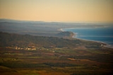
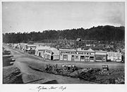
Ross, New Zealand
Encyclopedia

West Coast, New Zealand
The West Coast is one of the administrative regions of New Zealand, located on the west coast of the South Island, and is one of the more remote and most sparsely populated areas of the country. It is made up of three districts: Buller, Grey and Westland...
of New Zealand
New Zealand
New Zealand is an island country in the south-western Pacific Ocean comprising two main landmasses and numerous smaller islands. The country is situated some east of Australia across the Tasman Sea, and roughly south of the Pacific island nations of New Caledonia, Fiji, and Tonga...
's South Island
South Island
The South Island is the larger of the two major islands of New Zealand, the other being the more populous North Island. It is bordered to the north by Cook Strait, to the west by the Tasman Sea, to the south and east by the Pacific Ocean...
.
It lies 27 kilometres south-west of Hokitika and 46 kilometres north-east of Harihari
Harihari
Hari Hari -Maori Meaning, from Te Aka Maori/English Dictionary is "To Take/Carry Joy" or, as local legend suggests, "Come together in Unison" from a Maori canoe paddling chant/song. In recent years, Hari Hari has been increasingly referred to as "Harihari" – Maori Meaning is "Ambulance"...
. State Highway 6
New Zealand State Highway 6
State Highway 6 is a major New Zealand State Highway. It extends from the northeastern corner of the South Island across the top of the island, then down the length of the island, initially along the West Coast and then across the Southern Alps through inland Otago and finally across the Southland...
passes through Ross on its route from Ruatapu
Ruatapu, New Zealand
Ruatapu is the name of a small town in the Westland District of the West Coast region of New Zealand's South Island. Its name comes from a figure in Māori tradition named Ruatapu. The town is located to the west of Lake Mahinapua and is 12km southwest of Hokitika and 14km northeast of Ross. ...
south to Pukekura
Pukekura
Pukekura is located near Lake Ianthe in the West Coast region of the South Island. State Highway 6 passes through Pukekura on its route between Ross and Harihari, and the settlement is roughly 35 minutes south of Hokitika and an hour north of Franz Josef Glacier...
, Harihari
Harihari
Hari Hari -Maori Meaning, from Te Aka Maori/English Dictionary is "To Take/Carry Joy" or, as local legend suggests, "Come together in Unison" from a Maori canoe paddling chant/song. In recent years, Hari Hari has been increasingly referred to as "Harihari" – Maori Meaning is "Ambulance"...
, and further south, the Franz Josef Glacier
Franz Josef Glacier
The Franz Josef is a long glacier located in Westland Tai Poutini National Park on the West Coast of New Zealand's South Island...
.
The population was 291 in the 2006 Census
New Zealand Census of Population and Dwellings
The New Zealand government department Statistics New Zealand conducts a census of population and dwellings every five years. The census scheduled for 2011 was cancelled due to circumstances surrounding the February 2011 Christchurch earthquake, however, and legislation introduced to hold the next...
, a decrease of 24 from 2001..
The town's chief industries are farming and forestry
Forestry
Forestry is the interdisciplinary profession embracing the science, art, and craft of creating, managing, using, and conserving forests and associated resources in a sustainable manner to meet desired goals, needs, and values for human benefit. Forestry is practiced in plantations and natural stands...
. Ross was an important centre during the West Coast goldrush of the 1860s. Since 1988 a large open cast mine has operated adjacent to the town.
A branch line
Branch line
A branch line is a secondary railway line which branches off a more important through route, usually a main line. A very short branch line may be called a spur line...
railway known as the Ross Branch was opened to Ross on 1 April 1909, and this was the southern terminus of the line owned by the New Zealand Railways Department
New Zealand Railways Department
The New Zealand Railways Department, NZR or NZGR and often known as the "Railways", was a government department charged with owning and maintaining New Zealand's railway infrastructure and operating the railway system. The Department was created in 1880 and was reformed in 1981 into the New...
. However, a lengthy privately owned bush tramway ran south from the railway station to serve logging interests near Lake Ianthe
Lake Ianthe
Lake Ianthe is a lake located on the West Coast of New Zealand's South Island. A number of small streams flow into the lake and it empties into the Wanganui River...
and a railway extension from Ross through the Haast Pass
Haast Pass
Haast Pass is a mountain pass in the Southern Alps of the South Island of New Zealand. It is named for Julius von Haast, a 19th century explorer who was also geologist for the Provincial government of Canterbury...
to connect with the Otago Central Railway was proposed in the early 20th century. From the 1940s until 9 October 1962, a Vulcan railcar
NZR RM class (Vulcan)
The NZR RM class Vulcan railcars were operated by the New Zealand Railways Department in the South Island of New Zealand. All New Zealand railcars were classified as RM, and these were known as Vulcan railcars, from the name of the manufacturer, Vulcan Foundry of Britain. - Background :On 9 May...
service operated directly from Christchurch
Christchurch
Christchurch is the largest city in the South Island of New Zealand, and the country's second-largest urban area after Auckland. It lies one third of the way down the South Island's east coast, just north of Banks Peninsula which itself, since 2006, lies within the formal limits of...
to Ross twice a day. A lack of traffic and expensive maintenance costs meant the line was closed beyond Hokitika on 24 November 1980. Much of the old track bed
Track bed
A track bed or trackbed is the term used to describe the groundwork onto which a railway track is laid. Trackbeds of disused railways are sometimes used for recreational paths or new light rail links....
between Ruatapu and Hokitika can be driven as it serves as an access road for local farmers, and a disused truss bridge still stands north of Ross.
Education
Ross School is a coeducational contributing primary (years 1-6) school with a decile ratingSocio-Economic Decile
Decile, Socio-Economic Decile or Socio-Economic Decile Band is a widely used measure in education in New Zealand used to target funding and support to more needy schools....
of 6 and a roll of 24.