

Grey District
Encyclopedia
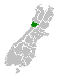
West Coast, New Zealand
The West Coast is one of the administrative regions of New Zealand, located on the west coast of the South Island, and is one of the more remote and most sparsely populated areas of the country. It is made up of three districts: Buller, Grey and Westland...
of New Zealand
New Zealand
New Zealand is an island country in the south-western Pacific Ocean comprising two main landmasses and numerous smaller islands. The country is situated some east of Australia across the Tasman Sea, and roughly south of the Pacific island nations of New Caledonia, Fiji, and Tonga...
is a municipality
Municipality
A municipality is essentially an urban administrative division having corporate status and usually powers of self-government. It can also be used to mean the governing body of a municipality. A municipality is a general-purpose administrative subdivision, as opposed to a special-purpose district...
that covers Greymouth
Greymouth
Greymouth is the largest town in the West Coast region in the South Island of New Zealand, and the seat of the Grey District Council. The population of the whole Grey District is , which accounts for % of the West Coast's inhabitants...
, Runanga
Runanga, New Zealand
Runanga is a small town on the West Coast of the South Island of New Zealand. It is located ten kilometres to the northwest of Greymouth, to the north of the Grey River. Barrytown is 21 kilometres further north...
, Blackball
Blackball, New Zealand
Blackball is a small town on the West Coast of the South Island of New Zealand, approximately 29 km from Greymouth.Blackball was named after the Black Ball Shipping Line, which leased land in the area to mine for coal. It was formerly known as Joliffetown and Moonlight Gully.Blackball is a centre...
, Cobden
Cobden, New Zealand
Cobden is a suburb to the north of Greymouth on the West Coast of New Zealand. The Grey River separates Cobden from the rest of Greymouth. To the north is the Rapahoe Range, also called the Twelve Apostles Range...
and settlements along the Grey River. It has a land area of 3,516.48 km² (1,357.72 sq mi). The seat of the council is at Greymouth, where 27% of the district's population live.