
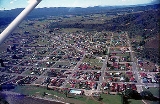
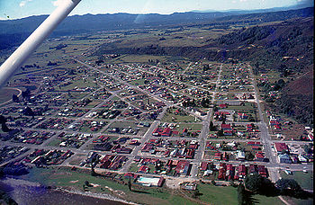
Reefton, New Zealand
Encyclopedia
New Zealand
New Zealand is an island country in the south-western Pacific Ocean comprising two main landmasses and numerous smaller islands. The country is situated some east of Australia across the Tasman Sea, and roughly south of the Pacific island nations of New Caledonia, Fiji, and Tonga...
's West Coast
West Coast, New Zealand
The West Coast is one of the administrative regions of New Zealand, located on the west coast of the South Island, and is one of the more remote and most sparsely populated areas of the country. It is made up of three districts: Buller, Grey and Westland...
region, some 80 km northeast of Greymouth, in the valley of the Inangahua River
Inangahua River
The Inangahua River is located in the northwest of New Zealand’s South Island. It is a major tributary of the Buller River, which it joins at the town of Inangahua Junction....
. State Highway 7
New Zealand State Highway 7
State Highway 7 is a major New Zealand State Highway. One of the eight national highways, it crosses the Southern Alps to link the West Coast Region with Canterbury and to form a link between the South Island's two longest highways, State Highway 1 and State Highway 6...
passes through the southern part of the town, and State Highway 69 runs north to connect to State Highway 6
New Zealand State Highway 6
State Highway 6 is a major New Zealand State Highway. It extends from the northeastern corner of the South Island across the top of the island, then down the length of the island, initially along the West Coast and then across the Southern Alps through inland Otago and finally across the Southland...
. Ahaura
Ahaura
Ahaura is a town in the West Coast region of New Zealand's South Island, sited where the Ahaura River flows into the Grey River. State Highway 7 and the Stillwater - Westport railway line pass through the town...
is 44 km south-west of Reefton, Inangahua Junction
Inangahua Junction
Inangahua Junction is a small town in the northwest of New Zealand's South Island. It is located at the confluence of the Inangahua and Buller Rivers, 34 kilometres north of Reefton and 46 kilometres southeast of Westport. Murchison is 52 kilometres to the east. The town of Inangahua is just to the...
is 34 km to the north, Maruia
Maruia
Maruia is a locality in the West Coast region of New Zealand. The Shenandoah Highway passes through it. Murchison is 65 km north, the Lewis Pass is 39 km to the south-east, and Reefton is 63 km west by road...
is 63 km to the east, and the Lewis Pass
Lewis Pass
Lewis Pass is a mountain pass in the South Island of New Zealand.The northernmost of the three main passes across the Southern Alps, it is higher than the Haast Pass, but slightly lower than Arthur's Pass...
is 66 km to the south-east.
In 1888 Reefton became the first town in New Zealand and the Southern Hemisphere
Southern Hemisphere
The Southern Hemisphere is the part of Earth that lies south of the equator. The word hemisphere literally means 'half ball' or "half sphere"...
to receive electricity, and its streets were lit by commercial electricity generated by the Reefton Power Station
Reefton Power Station
Reefton Power Station was the first power station to supply municipal electricity in the Southern Hemisphere.It supplied electricity to the town of Reefton in New Zealand. The power station turbine was run by water supplied from the Inangahua River via two tunnels and a headrace flume...
.
The population was 951 in the 2006 Census
New Zealand Census of Population and Dwellings
The New Zealand government department Statistics New Zealand conducts a census of population and dwellings every five years. The census scheduled for 2011 was cancelled due to circumstances surrounding the February 2011 Christchurch earthquake, however, and legislation introduced to hold the next...
, a decrease of 36 from 2001.
Industry
Rich veins of gold found in a quartzQuartz
Quartz is the second-most-abundant mineral in the Earth's continental crust, after feldspar. It is made up of a continuous framework of SiO4 silicon–oxygen tetrahedra, with each oxygen being shared between two tetrahedra, giving an overall formula SiO2. There are many different varieties of quartz,...
reef near the town led to its name, and also its former name of Quartzopolis. Gold was first discovered near the town in 1866, although the major discovery was made in 1870. Soon after, the town briefly boasted a population of several thousand. This has dwindled to less than a thousand, but with the opening of an Australian owned goldmine the population is expected to grow by several hundred. Other industries in the town are coal mining, forestry, tourism and angling.
Locally received radio stations include repeaters of both Classic Hits Scenicland FM from Greymouth
Greymouth
Greymouth is the largest town in the West Coast region in the South Island of New Zealand, and the seat of the Grey District Council. The population of the whole Grey District is , which accounts for % of the West Coast's inhabitants...
and Coast FM from Westport
Westport, New Zealand
-Economy:Economic activity is based around fishing, coal mining and dairy farming. Historically, gold mining was a major industry, and coal mining was much more extensive than today . However, the region still is home to New Zealand's largest opencast mining operation in Stockton...
. The Greymouth Star newspaper is also received daily in the town.
Railways
Reefton is located on the Stillwater - Westport LineStillwater - Westport Line
The Stillwater Ngakawau Line , formerly the Stillwater - Westport Line and the Ngakawau Branch, is a secondary main line, part of New Zealand's national rail network. It runs between Stillwater and Ngakawau via Westport on the West Coast of the South Island...
railway, which diverges from the Midland Line
Midland Line, New Zealand
The Midland line is a 212 km section of railway between Rolleston and Greymouth in the South Island of New Zealand. The line features five major bridges, five viaducts and 17 tunnels, the longest of which is the Otira tunnel.-Freight services:...
in Stillwater
Stillwater, West Coast
Stillwater is a town in the South Island of New Zealand east of Greymouth on the banks of the Grey River in the Grey District of the West Coast, next to Brunner. There is also Stillwater, Auckland in the North Island....
. On 29 February 1892, the line was opened to Reefton, but it terminated on the southern bank of the Inangahua River opposite the town. Early in the 20th century, a bridge was built across the river and the present-day station established in Reefton. The line was opened beyond Reefton to Cronadun
Cronadun
Cronadun is a small village located in the West Coast region of New Zealand's South Island. It is situated by the Inangahua River, and State Highway 69 and the Stillwater - Westport Line railway pass through the village...
in 1908, but it was not until 5 December 1943 that the line officially became a through route to Westport
Westport, New Zealand
-Economy:Economic activity is based around fishing, coal mining and dairy farming. Historically, gold mining was a major industry, and coal mining was much more extensive than today . However, the region still is home to New Zealand's largest opencast mining operation in Stockton...
, though trains had been operating the length of the line since July 1942. On 3 August 1936, a railcar
Railcar
A railcar, in British English and Australian English, is a self-propelled railway vehicle designed to transport passengers. The term "railcar" is usually used in reference to a train consisting of a single coach , with a driver's cab at one or both ends. Some railways, e.g., the Great Western...
passenger service began operating in the morning between Hokitika and Reefton utilising small Leyland diesel railcars
NZR RM class (Leyland diesel)
The NZR RM class Leyland diesel railcar or Midland railcar was the first diesel-powered vehicle to enter revenue service on New Zealand's national rail network. Two were built, RM 20 and RM 21, and they commenced service in August 1936 as temporary short-use vehicles that would operate until...
, but low patronage meant this service ceased to operate all the way to Reefton in August 1938. In the early 1940s, much larger Vulcan railcars
NZR RM class (Vulcan)
The NZR RM class Vulcan railcars were operated by the New Zealand Railways Department in the South Island of New Zealand. All New Zealand railcars were classified as RM, and these were known as Vulcan railcars, from the name of the manufacturer, Vulcan Foundry of Britain. - Background :On 9 May...
were introduced to New Zealand and they provided two services to Reefton: one local service from Greymouth that terminated in Reefton, and a service that ran between Westport and Stillwater to connect with the West Coast Express. In 1967, all passenger services through Reefton ceased. Today, the primary traffic on the railway is coal, with multiple coal trains operating daily.
Timeline
- 1866 - Gold discovered
- 1888 - Town electricity
- 1892 - Railway line opens.
- 1908 - line to Cronadun opened.
- 1912 - Reefton "lock out"
- 1967 - Rail passenger services cease.
Education
The first state school in Reefton was founded in 1878, and there were once 24 schools in the area.Reefton Area School is a composite (years 1-15) school with a decile rating
Socio-Economic Decile
Decile, Socio-Economic Decile or Socio-Economic Decile Band is a widely used measure in education in New Zealand used to target funding and support to more needy schools....
of 3 and a roll of 238. Reefton School and Inangahua College merged to form Reefton Area School in 2004. Sacred Heart School is a full primary (years 1-8) school with a decile rating of 4 and a roll of 47. It is a state integrated Catholic school. Both schools are coeducational.
External links
- Reefton i-SITE Visitor Centre
- Department of Conservation - Reefton short walks
- Reefton Area School