
Inangahua Junction
Encyclopedia
Inangahua Junction is a small town in the northwest of New Zealand
's South Island
. It is located at the confluence of the Inangahua
and Buller River
s, 34 kilometres north of Reefton
and 46 kilometres southeast of Westport
. Murchison
is 52 kilometres to the east. The town of Inangahua is just to the east of the junction. The town's main industries include forestry, coal, farming and sawmilling. There is a small primary school, shops, fire station and earthquake museum. The population was 159 in the 2006 Census
, an increase of 9 people from 2001. The name of the town refers to inanga, the Māori
word for whitebait
. Inangahua Junction was formerly known as Christies Junction.
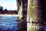
 The town was substantially affected by an earthquake on Friday, 24 May 1968. At 5:24am, the earthquake measuring 7.1 on the Richter scale
struck the town, and many landslides and aftershocks followed. The entire population of around 100 was temporarily evacuated. Two people were killed, and another three died later when a helicopter evacuating survivors crashed. No larger on-land earthquake subsequently occurred in New Zealand until the 7.1 magnitude earthquake in Christchurch on 4 September 2010
.
railway, and was intended to be the junction of this line with the never-completed Nelson Section
. In 1914, the railway was opened to Inangahua Junction from its former terminus in Cronadun
, but subsequent progress through the Buller Gorge was slow. In July 1942, trains began running the full length of the line between Stillwater
and Westport, but the line was not officially opened until 5 December 1943. With the commencement of through services, passenger trains were operated by RM class
Vulcan
railcar
s, which connected in Stillwater with services that ran along the Midland Line
between Greymouth
and Christchurch
. In 1967, the passenger services ceased, and today, the primary traffic is coal, with multiple coal trains passing through Inangahua Junction daily.
The other annual event held on the Inangahua site is PHAT MOON, a slightly smaller version of the bigger New Year's Eve event.
PHAT MOON is held over Easter weekend. The music runs for 24 hours, but people are invited to come and camp the night before.
of 6 and a roll of 9. The school was in existence in 1887.
Inangahua College merged with Reefton School to form Reefton Area School in 2004. The College, which existed for 38 years, replaced the Reefton District High School.
New Zealand
New Zealand is an island country in the south-western Pacific Ocean comprising two main landmasses and numerous smaller islands. The country is situated some east of Australia across the Tasman Sea, and roughly south of the Pacific island nations of New Caledonia, Fiji, and Tonga...
's South Island
South Island
The South Island is the larger of the two major islands of New Zealand, the other being the more populous North Island. It is bordered to the north by Cook Strait, to the west by the Tasman Sea, to the south and east by the Pacific Ocean...
. It is located at the confluence of the Inangahua
Inangahua River
The Inangahua River is located in the northwest of New Zealand’s South Island. It is a major tributary of the Buller River, which it joins at the town of Inangahua Junction....
and Buller River
Buller River
The Buller River is in the South Island of New Zealand. One of the country's longest rivers, it flows for 170 kilometres from Lake Rotoiti through the Buller Gorge and into the Tasman Sea near the town of Westport...
s, 34 kilometres north of Reefton
Reefton, New Zealand
Reefton is a small town on New Zealand's West Coast region, some 80 km northeast of Greymouth, in the valley of the Inangahua River. State Highway 7 passes through the southern part of the town, and State Highway 69 runs north to connect to State Highway 6...
and 46 kilometres southeast of Westport
Westport, New Zealand
-Economy:Economic activity is based around fishing, coal mining and dairy farming. Historically, gold mining was a major industry, and coal mining was much more extensive than today . However, the region still is home to New Zealand's largest opencast mining operation in Stockton...
. Murchison
Murchison, New Zealand
Murchison is a town in the Tasman Region of the South Island of New Zealand. It is near the western end of the "Four Rivers Plain", at the confluence of the Buller River and the Matakitaki River...
is 52 kilometres to the east. The town of Inangahua is just to the east of the junction. The town's main industries include forestry, coal, farming and sawmilling. There is a small primary school, shops, fire station and earthquake museum. The population was 159 in the 2006 Census
New Zealand Census of Population and Dwellings
The New Zealand government department Statistics New Zealand conducts a census of population and dwellings every five years. The census scheduled for 2011 was cancelled due to circumstances surrounding the February 2011 Christchurch earthquake, however, and legislation introduced to hold the next...
, an increase of 9 people from 2001. The name of the town refers to inanga, the Māori
Maori language
Māori or te reo Māori , commonly te reo , is the language of the indigenous population of New Zealand, the Māori. It has the status of an official language in New Zealand...
word for whitebait
Whitebait
Whitebait is a collective term for the immature fry of fish, typically between 25 and 50 millimetres long. Such young fish often travel together in schools along the coast, and move into estuaries and sometimes up rivers where they can be easily caught with fine meshed fishing nets...
. Inangahua Junction was formerly known as Christies Junction.
Earthquake
Richter magnitude scale
The expression Richter magnitude scale refers to a number of ways to assign a single number to quantify the energy contained in an earthquake....
struck the town, and many landslides and aftershocks followed. The entire population of around 100 was temporarily evacuated. Two people were killed, and another three died later when a helicopter evacuating survivors crashed. No larger on-land earthquake subsequently occurred in New Zealand until the 7.1 magnitude earthquake in Christchurch on 4 September 2010
2010 Canterbury earthquake
The 2010 Canterbury earthquake was a 7.1 magnitude earthquake, which struck the South Island of New Zealand at 4:35 am on local time ....
.
Railways
Inangahua Junction is located on the Stillwater - Westport LineStillwater - Westport Line
The Stillwater Ngakawau Line , formerly the Stillwater - Westport Line and the Ngakawau Branch, is a secondary main line, part of New Zealand's national rail network. It runs between Stillwater and Ngakawau via Westport on the West Coast of the South Island...
railway, and was intended to be the junction of this line with the never-completed Nelson Section
Nelson Section
The Nelson Section was an isolated, gauge, government-owned railway line between Nelson and Glenhope in the Tasman district of New Zealand's South Island. It operated for years between 1876 and 1955...
. In 1914, the railway was opened to Inangahua Junction from its former terminus in Cronadun
Cronadun
Cronadun is a small village located in the West Coast region of New Zealand's South Island. It is situated by the Inangahua River, and State Highway 69 and the Stillwater - Westport Line railway pass through the village...
, but subsequent progress through the Buller Gorge was slow. In July 1942, trains began running the full length of the line between Stillwater
Stillwater, West Coast
Stillwater is a town in the South Island of New Zealand east of Greymouth on the banks of the Grey River in the Grey District of the West Coast, next to Brunner. There is also Stillwater, Auckland in the North Island....
and Westport, but the line was not officially opened until 5 December 1943. With the commencement of through services, passenger trains were operated by RM class
NZR RM class
The RM class is the classification used by the New Zealand Railways Department and its successors given to most railcars and railbuses that have operated on New Zealand's national rail network. As NZR and its successors has operated many diverse types of railcars, alternate names have been given...
Vulcan
NZR RM class (Vulcan)
The NZR RM class Vulcan railcars were operated by the New Zealand Railways Department in the South Island of New Zealand. All New Zealand railcars were classified as RM, and these were known as Vulcan railcars, from the name of the manufacturer, Vulcan Foundry of Britain. - Background :On 9 May...
railcar
Railcar
A railcar, in British English and Australian English, is a self-propelled railway vehicle designed to transport passengers. The term "railcar" is usually used in reference to a train consisting of a single coach , with a driver's cab at one or both ends. Some railways, e.g., the Great Western...
s, which connected in Stillwater with services that ran along the Midland Line
Midland Line, New Zealand
The Midland line is a 212 km section of railway between Rolleston and Greymouth in the South Island of New Zealand. The line features five major bridges, five viaducts and 17 tunnels, the longest of which is the Otira tunnel.-Freight services:...
between Greymouth
Greymouth
Greymouth is the largest town in the West Coast region in the South Island of New Zealand, and the seat of the Grey District Council. The population of the whole Grey District is , which accounts for % of the West Coast's inhabitants...
and Christchurch
Christchurch
Christchurch is the largest city in the South Island of New Zealand, and the country's second-largest urban area after Auckland. It lies one third of the way down the South Island's east coast, just north of Banks Peninsula which itself, since 2006, lies within the formal limits of...
. In 1967, the passenger services ceased, and today, the primary traffic is coal, with multiple coal trains passing through Inangahua Junction daily.
PHAT Music Festival
Inangahua is the host of the PHAT New Year's Eve music festivals. PHAT07, PHAT08, PHAT09 featured New Zealand and many international acts. PHAT is held on flat clearings surrounded by rain forest on Rough Creek Road, off Browns Creek Road, south of Inangahua and owned by the Storer family. Approximately 5000 people attend the PHAT music festivals, with 48 hours of continuous performance on two stages.The other annual event held on the Inangahua site is PHAT MOON, a slightly smaller version of the bigger New Year's Eve event.
PHAT MOON is held over Easter weekend. The music runs for 24 hours, but people are invited to come and camp the night before.
Education
Inangahua Junction School is a coeducational contributing primary (years 1-6) school with a decile ratingSocio-Economic Decile
Decile, Socio-Economic Decile or Socio-Economic Decile Band is a widely used measure in education in New Zealand used to target funding and support to more needy schools....
of 6 and a roll of 9. The school was in existence in 1887.
Inangahua College merged with Reefton School to form Reefton Area School in 2004. The College, which existed for 38 years, replaced the Reefton District High School.