

Southern Scenic Route
Encyclopedia


New Zealand
New Zealand is an island country in the south-western Pacific Ocean comprising two main landmasses and numerous smaller islands. The country is situated some east of Australia across the Tasman Sea, and roughly south of the Pacific island nations of New Caledonia, Fiji, and Tonga...
linking Queenstown
Queenstown, New Zealand
Queenstown is a resort town in Otago in the south-west of New Zealand's South Island. It is built around an inlet called Queenstown Bay on Lake Wakatipu, a long thin Z-shaped lake formed by glacial processes, and has spectacular views of nearby mountains....
, Fiordland
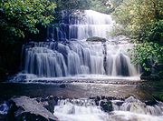
Fiordland
Fiordland is a geographic region of New Zealand that is situated on the south-western corner of the South Island, comprising the western-most third of Southland. Most of Fiordland is dominated by the steep sides of the snow-capped Southern Alps, deep lakes and its ocean-flooded, steep western valleys...
, Te Anau
Te Anau
Te Anau is a town in the South Island of New Zealand. It is on the eastern shore of Lake Te Anau in Fiordland. Lake Te Anau is the largest lake in the South Island and second only within New Zealand to Lake Taupo. The 2001 census recorded the town's population as 1,857...
and the iconic Milford Road to Dunedin
Dunedin
Dunedin is the second-largest city in the South Island of New Zealand, and the principal city of the Otago Region. It is considered to be one of the four main urban centres of New Zealand for historic, cultural, and geographic reasons. Dunedin was the largest city by territorial land area until...
via, Riverton
Riverton
Riverton is the name of several places:In Australia:*Riverton, South Australia, a small town and former railway junction in the mid north of South Australia*Riverton, Western Australia, a suburb of Perth, Western Australia...
, Invercargill
Invercargill
Invercargill is the southernmost and westernmost city in New Zealand, and one of the southernmost cities in the world. It is the commercial centre of the Southland region. It lies in the heart of the wide expanse of the Southland Plains on the Oreti or New River some 18 km north of Bluff,...
and The Catlins
The Catlins
The Catlins comprises an area in the southeastern corner of the South Island of New Zealand. The area lies between Balclutha and Invercargill, straddling the boundary between the Otago and Southland regions...
. An Australian travel magazine labelled it "one of the world's great undiscovered drives" in 2008.
History and development
The Southern Scenic Route concept and name were conceived at an informal gathering in TuatapereTuatapere
Tuatapere is a small rural town in Southland, New Zealand . It is located eight kilometres from the southern coast. The Waiau River flows through the town before reaching Te Waewae Bay, where it has its outflow into Foveaux Strait...
in November 1985 and confirmed at a public meeting
Meeting
In a meeting, two or more people come together to discuss one or more topics, often in a formal setting.- Definitions :An act or process of coming together as an assembly for a common purpose....
in January 1986. The promotors then negotiated with road
Road
A road is a thoroughfare, route, or way on land between two places, which typically has been paved or otherwise improved to allow travel by some conveyance, including a horse, cart, or motor vehicle. Roads consist of one, or sometimes two, roadways each with one or more lanes and also any...
and tourism
Tourism
Tourism is travel for recreational, leisure or business purposes. The World Tourism Organization defines tourists as people "traveling to and staying in places outside their usual environment for not more than one consecutive year for leisure, business and other purposes".Tourism has become a...
authorities and local government
Local government
Local government refers collectively to administrative authorities over areas that are smaller than a state.The term is used to contrast with offices at nation-state level, which are referred to as the central government, national government, or federal government...
.
The project was a first for New Zealand and approval was a slow process. At one stage, traffic sign
Traffic sign
Traffic signs or road signs are signs erected at the side of roads to provide information to road users. With traffic volumes increasing over the last eight decades, many countries have adopted pictorial signs or otherwise simplified and standardized their signs to facilitate international travel...
s were installed in a clandestine operation.
The Southern Scenic Route opened officially on 6 November 1988, initially Te Anau
Te Anau
Te Anau is a town in the South Island of New Zealand. It is on the eastern shore of Lake Te Anau in Fiordland. Lake Te Anau is the largest lake in the South Island and second only within New Zealand to Lake Taupo. The 2001 census recorded the town's population as 1,857...
-Balclutha
Balclutha, New Zealand
Balclutha is a town in Otago, it lies towards the end of the Clutha River on the east coast of the South Island of New Zealand. It is about halfway between Dunedin and Invercargill on the Main South Line railway, State Highway 1 and the Southern Scenic Route...
. The route was extended to Dunedin
Dunedin
Dunedin is the second-largest city in the South Island of New Zealand, and the principal city of the Otago Region. It is considered to be one of the four main urban centres of New Zealand for historic, cultural, and geographic reasons. Dunedin was the largest city by territorial land area until...
in 1998 and to Queenstown in 2010.
Current route

Queenstown, New Zealand
Queenstown is a resort town in Otago in the south-west of New Zealand's South Island. It is built around an inlet called Queenstown Bay on Lake Wakatipu, a long thin Z-shaped lake formed by glacial processes, and has spectacular views of nearby mountains....
to Dunedin
Dunedin
Dunedin is the second-largest city in the South Island of New Zealand, and the principal city of the Otago Region. It is considered to be one of the four main urban centres of New Zealand for historic, cultural, and geographic reasons. Dunedin was the largest city by territorial land area until...
. Skirting the eastern boundary of Fiordland National Park
Fiordland National Park
Fiordland National Park occupies the southwest corner of the South Island of New Zealand. It is the largest of the 14 national parks in New Zealand, with an area of 12,500 km², and a major part of the Te Wahipounamu World Heritage site...
the route passes Manapouri
Manapouri
Manapouri is a small town in Southland / Fiordland, in the southwest corner of the South Island, in New Zealand. Located at the edge of the Fiordland National Park, on the eastern shore of Lake Manapouri, close to its outflow into the Waiau River, tourist boat services are based in the...
and Tuatapere
Tuatapere
Tuatapere is a small rural town in Southland, New Zealand . It is located eight kilometres from the southern coast. The Waiau River flows through the town before reaching Te Waewae Bay, where it has its outflow into Foveaux Strait...
. At Te Waewae Bay
Te Waewae Bay
Te Waewae Bay is the westernmost of three large bays lying on the Foveaux Strait coast of Southland, New Zealand, the others being Oreti Beach and Toetoes Bay...
the coast is reached and the route swings eastward towards Orepuki
Orepuki
Orepuki in Southland, New Zealand is a small country township on the coast of Te Waewae Bay some 20 minutes from Riverton, 15 minutes from Tuatapere and 50 minutes from Invercargill that sits at the foot of the Longwood Range...
, Colac Bay
Colac Bay
Colac Bay is a small township on the Southern Scenic Route, 10 minutes from Riverton. Surrounding areas include Longwood, Tihaka, Waipango, Round Hill, Wakapatu, Ruahine, Pahia and Orepuki....
and Riverton
Riverton
Riverton is the name of several places:In Australia:*Riverton, South Australia, a small town and former railway junction in the mid north of South Australia*Riverton, Western Australia, a suburb of Perth, Western Australia...
. At Lorneville the New Zealand State Highway network
New Zealand State Highway network
The New Zealand State Highway network is the major national highway network in New Zealand. Just under 100 roads in both the North and South Islands are State Highways...
is joined, and the Southern Scenic Route follows Highway 6 south into Invercargill
Invercargill
Invercargill is the southernmost and westernmost city in New Zealand, and one of the southernmost cities in the world. It is the commercial centre of the Southland region. It lies in the heart of the wide expanse of the Southland Plains on the Oreti or New River some 18 km north of Bluff,...
.
From Invercargill the Southern Scenic Route heads east through Fortrose
Fortrose, New Zealand
Fortrose is a locality on the southernmost coast of the South Island of New Zealand in the Southland region. It is situated on Toetoes Bay at the mouth of the Mataura River, and is on the far western edge of the Catlins...
into the Catlins
The Catlins
The Catlins comprises an area in the southeastern corner of the South Island of New Zealand. The area lies between Balclutha and Invercargill, straddling the boundary between the Otago and Southland regions...
then through Owaka
Owaka
Owaka is a small town in Otago, in the southern South Island of New Zealand. It is the largest community in the rugged, forested Catlins area, close to the border with Southland, some south of Balclutha on the Southern Scenic Route. The town's population was 334 in the 2006 census, a decrease of...
to Balclutha. The next section of rugged coastline with poor roading through Kaitangata
Kaitangata
Kaitangata can mean the following:*Kaitangata, New Zealand, a small town near the coast of South Otago in New Zealand*Kaitangata , a character in Māori mythology...
is avoided as the Southern Scenic Route follows SH1
State Highway 1 (New Zealand)
State Highway 1 is the longest and most significant road in the New Zealand roading network, running the length of both main islands. It appears on road maps as SH 1 and on road signs as a white number 1 on a red shield, but it has the official designations SH 1N in the North Island, SH 1S in the...
to Milton
Milton, New Zealand
Milton is a town of 2,000 people, located on State Highway 1, 50 kilometres to the south of Dunedin in Otago, New Zealand. It lies on the floodplain of the Tokomairiro River, one branch of which loops past the north and south ends of the town...
and Lake Waihola
Lake Waihola
Lake Waihola is a tidal freshwater lake located 15 km north of Milton in Otago, in New Zealand's South Island. Its area is some 9 square kilometres, with a maximum length of 6 kilometres....
.
The Southern Scenic Route leaves the highway at Waihola and climbs through Otago Coast Forest rejoining the coastline at Taieri Mouth
Taieri Mouth
Taieri Mouth is a small fishing village at the mouth of the Taieri River, New Zealand. Taieri Island lies in the ocean several hundred metres off the river's mouth.It has a white sand beach for swimming and several picnic areas...
. From here the route follows secondary roads through Brighton
Brighton, New Zealand
"Ocean View, New Zealand" redirects here. For the inner Dunedin suburb occasionally referred to as Ocean View, see Andersons BayBrighton is a small seaside town within the city limits of Dunedin, in New Zealand's South Island. It is located 20 kilometres southwest from the city centre on the...
and Green Island
Green Island, New Zealand
Green Island is an island off the coast of Dunedin, New Zealand, also the name of one of the city's suburbs. The suburb is not on the sea — formerly a borough, it took its name from the Green Island bush, uncleared native forest extending from the valley where the town is centred over the hills...
ending where it meets SH1 again at Caversham
Caversham, New Zealand
Caversham is one of the older suburbs of the South Island New Zealand city of Dunedin. It is sited at the western edge of the city's central plain at the mouth of the steep Caversham Valley, which rises to the saddle of Lookout Point...
.
Proposed extensions
In early 2007 a proposal arose to extend the route northward beyond Dunedin through WaitatiWaitati
Waitati is a small seaside settlement in Otago, New Zealand, within the city limits of Dunedin. It is located close to the tidal mudflats of Blueskin Bay, 19 kilometres north of the Dunedin city centre...
. Later, in November 2007, the Dunedin City Council confirmed that it planned to talk with the Waitaki District Council about extending the route to Oamaru
Oamaru
Oamaru , the largest town in North Otago, in the South Island of New Zealand, is the main town in the Waitaki District. It is 80 kilometres south of Timaru and 120 kilometres north of Dunedin, on the Pacific coast, and State Highway 1 and the railway Main South Line connects it to both...
, an idea that was not adopted. In 2010 the route was officially extended to Queenstown.