
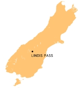
Lindis Pass
Encyclopedia
Lindis Pass is located in the South Island
of New Zealand
.
It lies between the towns of Cromwell
in Central Otago
and Omarama
in North Otago, on the main inland route to the Mackenzie Basin
in Canterbury.
The pass lies between the valleys of the Lindis
and Ahuriri River
s.
State Highway 8
transverses the pass on its route from the Mackenzie Basin to Central Otago. The pass is the highest point on the South Island's state highway network, and the second highest point on the New Zealand State Highway network
, after the Desert Road (SH 1) in the Central North Island.
South Island
The South Island is the larger of the two major islands of New Zealand, the other being the more populous North Island. It is bordered to the north by Cook Strait, to the west by the Tasman Sea, to the south and east by the Pacific Ocean...
of New Zealand
New Zealand
New Zealand is an island country in the south-western Pacific Ocean comprising two main landmasses and numerous smaller islands. The country is situated some east of Australia across the Tasman Sea, and roughly south of the Pacific island nations of New Caledonia, Fiji, and Tonga...
.
It lies between the towns of Cromwell
Cromwell, New Zealand
Cromwell is a town in Central Otago in the Otago region of New Zealand.It is situated between State Highway 6 and State Highway 8 leading to the Lindis Pass, 75 km northeast, and Alexandra, 33 km south. The road to Alexandra winds through the Cromwell Gorge...
in Central Otago
Central Otago
Central Otago is the inland part of the New Zealand region of Otago in the South Island. The area commonly known as Central Otago includes both the Central Otago District and the Queenstown-Lakes District to the west....
and Omarama
Omarama
Omarama is a small township at the junction of State Highways 8 and 83, near the southern end of the Mackenzie Basin, in the South Island of New Zealand. Omarama is in the Waitaki District, in the historic Province of Otago...
in North Otago, on the main inland route to the Mackenzie Basin
Mackenzie Basin
The Mackenzie Basin , is an elliptical intermontane basin, located in the Mackenzie and Waitaki Districts, near the centre of the South Island of New Zealand. It is the largest such basin in New Zealand...
in Canterbury.
The pass lies between the valleys of the Lindis
Lindis River
The Lindis River is found in Otago in the South Island of New Zealand. It is a tributary of the Clutha River, flowing south for 55 kilometres through the Lindis Pass, site of the main inland road route between Otago and the Mackenzie Basin in Canterbury....
and Ahuriri River
Ahuriri River
The Ahuriri River is a river in the Otago region of the South Island of New Zealand.The headwaters are on the eastern flanks of the Southern Alps. The river flows for 70 kilometres through the southernmost part of the Mackenzie Basin before reaching the Ahuriri Arm of Lake Benmore, one of the...
s.
State Highway 8
New Zealand State Highway 8
State Highway 8 is one of New Zealand's eight national highways. It forms an anticlockwise loop through the southern scenic regions of the Mackenzie Basin and Central Otago, starting and terminating in junctions with State Highway 1...
transverses the pass on its route from the Mackenzie Basin to Central Otago. The pass is the highest point on the South Island's state highway network, and the second highest point on the New Zealand State Highway network
New Zealand State Highway network
The New Zealand State Highway network is the major national highway network in New Zealand. Just under 100 roads in both the North and South Islands are State Highways...
, after the Desert Road (SH 1) in the Central North Island.