

List of largest reservoirs of California
Encyclopedia
This is a list of the largest reservoir
s, or man-made lakes, in the U.S.
state of California
. All thirty-six reservoirs that contain over 200000 acre.ft of water at maximum capacity are listed. This includes those formed by raising the level of natural lakes, such as at Lake Tahoe
. Most large reservoirs in California are owned by the federal Bureau of Reclamation and to a lesser extent the Army Corps of Engineers, many serving the Central Valley Project
or State Water Project
. Smaller ones are often run by county water agencies or irrigation and flood control districts.
The state has more than one thousand major reservoirs, of which the largest two hundred have a combined capacity of over 41000000 acre.ft. Most large reservoirs in California are located in the central and northern portions of the state, especially along the large and flood-prone rivers of the Central Valley. Eleven reservoirs have a storage capacity greater than or equal to 1000000 acre.ft; all of these except one are in or on drainages that feed into the Central Valley. The largest single reservoir in California is Shasta Lake
, with a full volume of more than 4552000 acre.ft.
denotes reservoir not entirely in California
Reservoir
A reservoir , artificial lake or dam is used to store water.Reservoirs may be created in river valleys by the construction of a dam or may be built by excavation in the ground or by conventional construction techniques such as brickwork or cast concrete.The term reservoir may also be used to...
s, or man-made lakes, in the U.S.
United States
The United States of America is a federal constitutional republic comprising fifty states and a federal district...
state of California
California
California is a state located on the West Coast of the United States. It is by far the most populous U.S. state, and the third-largest by land area...
. All thirty-six reservoirs that contain over 200000 acre.ft of water at maximum capacity are listed. This includes those formed by raising the level of natural lakes, such as at Lake Tahoe
Lake Tahoe
Lake Tahoe is a large freshwater lake in the Sierra Nevada of the United States. At a surface elevation of , it is located along the border between California and Nevada, west of Carson City. Lake Tahoe is the largest alpine lake in North America. Its depth is , making it the USA's second-deepest...
. Most large reservoirs in California are owned by the federal Bureau of Reclamation and to a lesser extent the Army Corps of Engineers, many serving the Central Valley Project
Central Valley Project
The Central Valley Project is a Bureau of Reclamation federal water project in the U.S. state of California. It was devised in 1933 in order to provide irrigation and municipal water to much of California's Central Valley—by regulating and storing water in reservoirs in the water-rich northern...
or State Water Project
California State Water Project
The California State Water Project, commonly known as the SWP , is the world's largest publicly built and operated water and power development and conveyance system. The SWP was designed and is operated by the California Department of Water Resources...
. Smaller ones are often run by county water agencies or irrigation and flood control districts.
The state has more than one thousand major reservoirs, of which the largest two hundred have a combined capacity of over 41000000 acre.ft. Most large reservoirs in California are located in the central and northern portions of the state, especially along the large and flood-prone rivers of the Central Valley. Eleven reservoirs have a storage capacity greater than or equal to 1000000 acre.ft; all of these except one are in or on drainages that feed into the Central Valley. The largest single reservoir in California is Shasta Lake
Shasta Lake
Shasta Lake, also called Lake Shasta, is an artificial lake created by the construction of Shasta Dam across the Sacramento River in the Shasta-Trinity National Forest of Shasta County, California...
, with a full volume of more than 4552000 acre.ft.
| denotes reservoir that is offstream or receives most of its water from a source not associated with its feeder stream(s). |
List
| Name | County(s) | Coordinates | Volume (km3) | Image | |||
|---|---|---|---|---|---|---|---|
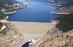
| Shasta Lake Shasta Lake Shasta Lake, also called Lake Shasta, is an artificial lake created by the construction of Shasta Dam across the Sacramento River in the Shasta-Trinity National Forest of Shasta County, California... |
Shasta Shasta County, California Shasta County is a county located in the northern portion of the U.S. state of California. The county occupies the northern reaches of the Sacramento Valley, with portions extending into the southern reaches of the Cascade Range. As of the 2010 census, the population was 177,223, up from 163,256... |
40°45′15"N 122°21′13"W | 4,552,000 | 5.615 | Sacramento River Sacramento River The Sacramento River is an important watercourse of Northern and Central California in the United States. The largest river in California, it rises on the eastern slopes of the Klamath Mountains, and after a journey south of over , empties into Suisun Bay, an arm of the San Francisco Bay, and... |
Shasta Dam Shasta Dam Shasta Dam is an arch dam across the Sacramento River in the northern part of the U.S. state of California, at the north end of the Sacramento Valley. The dam mainly serves long-term water storage and flood control in its reservoir, Shasta Lake, and also generates hydroelectric power... |
|
| Lake Oroville Lake Oroville Lake Oroville, also known as Lake Edmonston, is a reservoir in the U.S. state of California, formed by the Oroville Dam across the Feather River. The lake is situated in the foothills of the Sierra Nevada about northeast of Oroville. At over , it is one of the largest reservoirs in California,... |
Butte Butte County, California Butte County is a county located in the Central Valley of the US state of California, north of the state capital of Sacramento. As of the 2010 census, it had a population of 220,000. The county seat is Oroville. Butte County is the "Land of Natural Wealth and Beauty."Butte County is watered by the... |
39°32′14"N 121°29′00"W | 3,537,577 | 4.364 | Feather River Feather River The Feather River is the principal tributary of the Sacramento River, in the Sacramento Valley of Northern California. The river's main stem is about long. Its length to its most distant headwater tributary is about . Its drainage basin is about... |
Oroville Dam Oroville Dam Oroville Dam spans the Feather River about northeast of the city of Oroville, California. It forms Lake Oroville, which stores water for irrigation, flood control, municipal water supply and hydroelectricity generation in California's Sacramento Valley. The dam lies in the foothills of the Sierra... |
 |
| Trinity Lake Trinity Lake Trinity Lake, previously called Clair Engle Lake, is a lake on the Trinity River formed by the Trinity Dam and located in Trinity County, California, The dam was built by the U.S. Bureau of Reclamation. The lake has a capacity of , making it one of the largest reservoirs in California. The lake's... |
Trinity Trinity County, California Trinity County is a large, rugged and mountainous, heavily forested county located in the northwestern portion of the U.S. state of California, along the Trinity River and within the Salmon/Klamath Mountains. It covers an area of over two million acres , and as of the 2010 census its population... |
40°51′36"N 122°43′24"W | 2,448,000 | 3.020 | Trinity River Trinity River (California) The Trinity River is the longest tributary of the Klamath River, approximately long, in northwestern California in the United States. It drains an area of the Coast Ranges, including the southern Klamath Mountains, northwest of the Sacramento Valley... |
Trinity Dam Trinity Dam Trinity Dam is an earth dam on the Trinity River that forms Trinity Lake near Weaverville, California. Trinity Lake was previously called Clair Engle Lake. The earthfill dam was built by the U.S. Bureau of Reclamation. Construction was completed in 1962. Trinity Lake has a capacity of , making it... |
 |
| New Melones Lake New Melones Lake New Melones Lake is an artificial lake in the central Sierra Nevada foothills of Calaveras- and Tuolumne County, California near Jamestown. This reservoir created by the construction of the New Melones Dam across the Stanislaus River has a capacity with a surface area of... |
Tuolumne Tuolumne County, California Tuolumne County is a county in the Sierra Nevada of the U.S. state of California. The northern half of Yosemite National Park is located in the eastern part of the county. As of the 2010 census, the population was 55,365, up from 54,501 at the 2000 census... , Calaveras Calaveras County, California Calaveras County is a county located in the Gold Country of the U.S. state of California. Calaveras is the Spanish word for skulls; the county was reportedly named for the remains of Native Americans discovered by the Spanish explorer Captain Gabriel Moraga. As of the 2010 census, the county had a... |
38°00′02"N 120°31′12"W | 2,400,000 | 2.960 | Stanislaus River Stanislaus River The Stanislaus River in California is one of the largest tributaries of the San Joaquin River. The river is long and has north, middle and south forks... |
New Melones Dam New Melones Dam New Melones Dam is an earth and rock filled dam across the Stanislaus River creating New Melones Lake. Situated between Calaveras and Tuolumne County, California in the Sierra Nevada foothills near Jamestown, the dam was completed in 1979 replacing the old Melones Dam.-Background:The dam was... |
 |
| San Luis Reservoir San Luis Reservoir The San Luis Reservoir is an off-stream artificial lake in the eastern slopes of the Diablo Range of Merced County, California, approximately west of Los Banos on State Route 152, which crosses Pacheco Pass and runs along its north shore. The reservoir stores water taken from the San... |
Merced Merced County, California Merced County , is a county located in the Central Valley of the U.S. state of California, north of Fresno and southeast of San Jose. As of the 2010 census, the population was 255,793, up from 210,554 at the 2000 census. The county seat is Merced... |
37°04′04"N 121°07′52"W | 2,041,000 | 2.518 | San Luis Creek San Luis Creek (California) San Luis Creek, originally Arroyo de San Luis Gonzaga, is a stream in Merced County, California. Its source is located in Merced County, about 1000 ft. northwest of 3448 ft. high Mariposa Peak, on the Merced County - San Benito County boundry and 7.4 miles south of Pacheco Pass... |
San Luis Dam San Luis Dam San Luis Dam is a dam that creates San Luis Reservoir, which serves as an off-stream reservoir for the California State Water Project and the Central Valley Project. It is also known as the B.F. Sisk Dam, after Bernie Sisk. The earth-fill gravity embankment dam is 305 feet tall and was completed... |
|
| Don Pedro Reservoir | Tuolumne Tuolumne County, California Tuolumne County is a county in the Sierra Nevada of the U.S. state of California. The northern half of Yosemite National Park is located in the eastern part of the county. As of the 2010 census, the population was 55,365, up from 54,501 at the 2000 census... |
37°44′30"N 120°22′25"W | 2,030,000 | 2.504 | Tuolumne River Tuolumne River The Tuolumne River is a California river that flows nearly from the central Sierra Nevada to the San Joaquin River in the Central Valley... |
New Don Pedro Dam New Don Pedro Dam New Don Pedro Dam is built across the Tuolumne River and creates Lake Don Pedro in the foothills of the Sierra Nevada mountain range in the U.S. state of California. The New Don Pedro Dam takes its name from Don Pedros Bar which was named after Pierre "Don Pedro" Sainsevain... |
|
| Lake Berryessa Lake Berryessa Lake Berryessa is the largest lake in Napa County, California. This reservoir is formed by the Monticello Dam, which provides water and hydroelectricity to the North Bay region of the San Francisco Bay Area.... |
Napa Napa County, California Napa County is a county located north of the San Francisco Bay Area in the U.S. state of California. It is coterminous with the Napa, California, Metropolitan Statistical Area. As of 2010 the population is 136,484. The county seat is Napa.... |
38°31′53"N 122°09′49"W | 1,602,000 | 1.976 | Putah Creek Putah Creek Putah Creek is a major stream in Northern California, a tributary of the Yolo Bypass. The creek has its headwaters in the Mayacamas Mountains, a part of the Coast Range... |
Monticello Dam Monticello Dam Monticello Dam is a dam in Napa County, California, United States constructed between 1953 and 1957. It is a medium concrete-arch dam with a structural height of 304 ft and a crest length of . It contains 326,000 cubic yards of concrete... |
|
| Lake Almanor Lake Almanor Lake Almanor is a large artificial lake in northwestern Plumas County, northeastern California. The reservoir has a capacity of and a maximum depth of about 90 feet... |
Plumas Plumas County, California Plumas County is a county located in the Sierra Nevada of the U.S. state of California. The county gets its name from the Spanish words for the Feather River , which flows through the county. As of the 2010 census, the population 20,007, down from 20,824 at the 2000 census... |
40°13′47"N 121°09′29"W | 1,308,000 | 1.613 | North Feather River North Fork Feather River The North Fork Feather River is a watercourse of the northern Sierra Nevada in the U.S. state of California. It flows generally southwards from its headwaters near Lassen Peak to Lake Oroville, a reservoir formed by Oroville Dam in the foothills of the Sierra, where it runs into the Feather River.... |
Canyon Dam Canyon Dam (California) Canyon Dam is an embankment dam on the North Fork Feather River in northern California, southwest of Westwood. Located about southeast of Chester, the dam forms Lake Almanor, a large and shallow reservoir surrounded by the Sierra Nevada mountains.... |
|
| Folsom Lake Folsom Lake Folsom Lake is a reservoir in Northern California about northeast of Sacramento in Placer, El Dorado, and Sacramento Counties. The lake is formed by Folsom Dam, constructed in 1955 to control the American River. The dam and lake are part of the Folsom Project, which also includes the Nimbus... |
Sacramento Sacramento County, California Sacramento County is a county in the U.S. state of California. Its county seat is Sacramento, which is also the state capital. As of 2010 the county had a population of 1,418,788.... |
38°43′26"N 121°07′03"W | 1,120,200 | 1.382 | American River American River The American River is a California watercourse noted as the site of Sutter's Mill, northwest of Placerville, California, where gold was found in 1848, leading to the California Gold Rush... |
Folsom Dam Folsom Dam Folsom Dam is a concrete gravity dam on the American River in Northern California, about northeast of Sacramento. Folsom Dam is high concrete and long, flanked by earthen wing dams... |
|
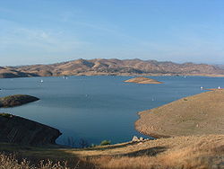
| Lake McClure Lake McClure Lake McClure is a artificial lake in western Mariposa County, California, about east of Modesto. It is formed by New Exchequer Dam on the Merced River, a tributary of the San Joaquin River, and its capacity is . It is a rock-fill dam with a reinforced concrete face and was completed in 1967... |
Mariposa Mariposa County, California Mariposa County is a county in the U.S. state of California, located in the western foothills of the Sierra Nevada mountains. It lies north of Fresno, east of Merced, and southeast of Stockton. As of the 2010 census, the population was 18,251 up from 17,130 at the 2000 census... |
37°38′11"N 120°16′49"W | 1,024,600 | 1.264 | Merced River Merced River The Merced River , in the central part of the U.S. state of California, is a -long tributary of the San Joaquin River flowing from the Sierra Nevada into the Central Valley. It is most well known for its swift and steep course through the southern part of Yosemite National Park, and the... |
New Exchequer Dam New Exchequer Dam New Exchequer Dam is an earthfill dam on the Merced River in central California. It is mainly used by the Merced Irrigation District to provide irrigation water to several hundred square miles of the San Joaquin Valley surrounding the line of the Merced River.The dam was built to increase the... |
|
| Pine Flat Lake Pine Flat Lake Pine Flat Lake is an artificial lake in the Sierra Nevada foothills of eastern Fresno County, California and provides the western north-south border to the Sierra- and Sequoia National Forests, about east of Fresno.... |
Fresno Fresno County, California Fresno County is a county located in the Central Valley of the U.S. state of California, south of Stockton and north of Bakersfield. As of the 2010 census, it is the tenth most populous county in California with a population of 930,450, and the sixth largest in size with an area of . The county... |
36°49′57"N 119°19′33"W | 1,000,000 | 1.233 | Kings River Kings River (California) The Kings River is a major river of south-central California. About long, it drains an area of the high western Sierra Nevada and the Central Valley. A large alluvial fan has formed where the river's gradient decreases in the Central Valley so the river divides into distributaries... |
Pine Flat Dam Pine Flat Dam Pine Flat Dam is on the Kings River in the San Joaquin Valley, near Piedra in Fresno County, California, and forms Pine Flat Lake. It is a concrete gravity dam. The dam is owned and operated by the U.S. Army Corps of Engineers. Construction of the dam began in 1949 and was completed in 1954... |
|
| New Bullards Bar Reservoir New Bullards Bar Reservoir New Bullards Bar Reservoir is a large reservoir in northeastern Yuba County, California, at an elevation of in the Tahoe National Forest and about 30 miles northeast of Yuba City, California. The reservoir is formed by New Bullards Bar Dam on the North Fork of the Yuba River, a tributary of the... |
Yuba Yuba County, California Yuba County is a county located in the U.S. state of California's Central Valley, north of Sacramento, along the Feather River. As of the 2010 census, its population was 72,155. The county seat is Marysville. Yuba County is part of the Greater Sacramento area.-History:Yuba County was one of the... |
39°23′32"N 121°08′30"W | 996,103 | 1.229 | North Yuba River North Yuba River The North Yuba River is the main tributary of the Yuba River in northern California in the United States. The river is about long and drains from the Sierra Nevada westwards towards the foothills between the mountains and the Sacramento Valley.It rises on the Sierra Crest about northwest of... |
New Bullards Bar Dam New Bullards Bar Dam New Bullards Bar Dam is a dam in California on the North Yuba River and forms the New Bullards Bar Reservoir, which has a capacity of . It is located near the town of Dobbins in Yuba County. The dam is operated by the Yuba County Water Agency for irrigation, drinking water and hydroelectric power... |
|
| Diamond Valley Lake Diamond Valley Lake The embankment required of crushed rock. An on-site crushing plant crushed and processed over 14 million tons of rock in 20 months to supply the dam's materials. The cut-off wall, which consists of a thick plastic concrete mix constructed through the weathered portion of bedrock, varies in depth... |
Riverside Riverside County, California Riverside County is a county in the U.S. state of California. One of 58 California counties, it covers in the southern part of the state, and stretches from Orange County to the Colorado River, which forms the state border with Arizona. The county derives its name from the city of Riverside,... |
33°40′42"N 117°02′30"W | 810,000 | 0.999 | Domenigoni Creek | West Dam | |
| Lake Tahoe Lake Tahoe Lake Tahoe is a large freshwater lake in the Sierra Nevada of the United States. At a surface elevation of , it is located along the border between California and Nevada, west of Carson City. Lake Tahoe is the largest alpine lake in North America. Its depth is , making it the USA's second-deepest... |
Placer Placer County, California Placer County is a county located in both the Sacramento Valley and Sierra Nevada regions of the U.S. state of California, in what is known as the Gold Country. It stretches from the suburbs of Sacramento to Lake Tahoe and the Nevada border. Because of the expansion of the Greater Sacramento,... , El Dorado El Dorado County, California El Dorado County is a county located in the historic Gold Country in the Sierra Nevada Mountains and foothills of the U.S. state of California. The 2010 population was 181,058. The El Dorado county seat is in Placerville.... , Douglas (NV) Douglas County, Nevada Douglas County is a county located in the northwestern part of the U.S. state of Nevada. As of 2000, the population was 41,259. As of 2010, the population was estimated to be 46,997.- History :... , Washoe (NV) Washoe County, Nevada Washoe County is a county located in the U.S. state of Nevada. The population was 421,407 at the 2010 census. Its county seat is Reno. Washoe County includes the Reno-Sparks metropolitan area.-History:... |
39°04′59"N 120°02′03"W | 732,000 | 0.903 | Truckee River Truckee River The Truckee River is a stream in the U.S. states of California and Nevada. The river is about long. Its endorheic drainage basin is about , of which about are in Nevada. The Truckee is the sole outlet of Lake Tahoe and drains part of the high Sierra Nevada, emptying into Pyramid Lake in the Great... |
Lake Tahoe Dam | 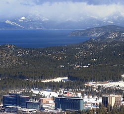 |
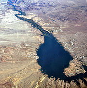
| Lake Havasu Lake Havasu Lake Havasu is a large reservoir behind Parker Dam on the Colorado River, on the border between California and Arizona. Lake Havasu City sits on the lake's eastern shore. The lake has a capacity of . The concrete arch dam was built by the United States Bureau of Reclamation between 1934 and 1938... |
San Bernardino San Bernardino County, California San Bernardino County is a county in the U.S. state of California. As of the 2010 census, the population was 2,035,210, up from 1,709,434 as of the 2000 census... , Mohave (AZ) Mohave County, Arizona Mohave County is located in the northwestern corner of the U.S. state of Arizona. As of the 2010 census, its population was 200,186, an increase of 45,154 people since the 2000 census count of 155,032. The county seat is Kingman... , La Paz (AZ) La Paz County, Arizona La Paz County is a county in the western part of the U.S. state of Arizona. As of the 2010 census its population was 20,489. The county seat is Parker... |
34°23′00"N 114°14′33"W | 646,200 | 0.797 | Colorado River Colorado River The Colorado River , is a river in the Southwestern United States and northwestern Mexico, approximately long, draining a part of the arid regions on the western slope of the Rocky Mountains. The watershed of the Colorado River covers in parts of seven U.S. states and two Mexican states... |
Parker Dam Parker Dam Parker Dam is a concrete arch-gravity dam that crosses the Colorado River downstream of Hoover Dam. Built between 1934 and 1938 by the Bureau of Reclamation, it is high, of which are below the riverbed, making it "the deepest dam in the world". The dam's primary functions are to create a... |
 |
| Lake Isabella Lake Isabella Lake Isabella is a reservoir in Kern County, California created by the earthen Isabella Dam. It was formed in 1953 when the U.S. Army Corps of Engineers dammed the Kern River at the junction of its two forks at Whiskey Flat. At 11,000 acres , it is one of the larger reservoirs in California... |
Kern Kern County, California Spreading across the southern end of the California Central Valley, Kern County is the fifth-largest county by population in California. Its economy is heavily linked to agriculture and to petroleum extraction, and there is a strong aviation and space presence. Politically, it has generally... |
35°38′47"N 118°28′56"W | 568,000 | 0.701 | Kern River Kern River The Kern River is a river in the U.S. state of California, approximately long. It drains an area of the southern Sierra Nevada mountains northeast of Bakersfield. Fed by snowmelt near Mount Whitney, the river passes through scenic canyons in the mountains and is a popular destination for... |
Isabella Dam Isabella Dam Isabella Dam is an embankment dam located about halfway down the Kern River, between the towns of Kernville and Lake Isabella in Kern County, California. Isabella Dam serves agricultural, hydroelectric, and flood control uses.-History:... |
|
| Clear Lake Reservoir Clear Lake Reservoir Clear Lake Reservoir is a reservoir in northwestern Modoc County, California in the Modoc National Forest about northwest of Alturas. It is formed by Clear Lake Dam on the Lost River and has a capacity of... |
Modoc Modoc County, California Modoc County is a county located in the far northeast corner of the U.S. state of California, bounded by the state of Oregon to the north and the state of Nevada to the east. As of the 2010 census, its population was 9,686, up from 9,449 at the 2000 census. The current county seat is Alturas, the... |
41°50′59"N 121°10′14"W | 527,000 | 0.650 | Lost River Lost River (California) Lost River begins and ends in a closed basin in northern California and southwestern Oregon in the United States. The river, long, flows in an arc from Clear Lake Reservoir in Modoc County, California, through Klamath County, Oregon to Tule Lake in Siskiyou County... |
Clear Lake Dam | |
| Millerton Lake Millerton Lake Millerton Lake is an artificial lake near the town of Friant about north of downtown Fresno. The reservoir was created by the construction of Friant Dam on the San Joaquin River which with the lake serves as much of the county line between Fresno County to the south and Madera County to the... |
Fresno Fresno County, California Fresno County is a county located in the Central Valley of the U.S. state of California, south of Stockton and north of Bakersfield. As of the 2010 census, it is the tenth most populous county in California with a population of 930,450, and the sixth largest in size with an area of . The county... , Madera Madera County, California Madera County is a county of the U.S. state of California, located in the Central Valley and the Sierra Nevada north of Fresno County. It comprises the Madera-Chowchilla, CA Metropolitan Statistical Area. As of the 2010 census the population was 150,865... |
36°59′51"N 119°41′36"W | 520,500 | 0.642 | San Joaquin River San Joaquin River The San Joaquin River is the largest river of Central California in the United States. At over long, the river starts in the high Sierra Nevada, and flows through a rich agricultural region known as the San Joaquin Valley before reaching Suisun Bay, San Francisco Bay, and the Pacific Ocean... |
Friant Dam Friant Dam Friant Dam is a concrete gravity dam on the upper San Joaquin River in the Sierra Nevada foothills of Fresno County and Madera County near the town of Friant. The dam, completed in 1942, forms Millerton Lake and was built by the U.S. Bureau of Reclamation, which owns and operates the dam. The lake... |
 |
| Camanche Reservoir | San Joaquin San Joaquin County, California San Joaquin County is a county located in Central Valley of the U.S. state of California, just east of the San Francisco Bay Area. As of the 2010 census, the population was 685,306. The county seat is Stockton.-History:... , Amador Amador County, California Amador County is a county located in the Sierra Nevada of the U.S. state of California. As of the 2010 census, the population was 38,091. The county seat is Jackson.Amador County bills itself as "The Heart of the Mother Lode" and lies within the Gold Country... , Calaveras Calaveras County, California Calaveras County is a county located in the Gold Country of the U.S. state of California. Calaveras is the Spanish word for skulls; the county was reportedly named for the remains of Native Americans discovered by the Spanish explorer Captain Gabriel Moraga. As of the 2010 census, the county had a... |
38°13′26"N 120°58′04"W | 431,000 | 0.532 | Mokelumne River Mokelumne River The Mokelumne River is a river in Northern California. The Upper Mokelumne River originates in the Sierra Nevada mountain range and flows into Pardee Reservoir and then Camanche Reservoir in the Sierra foothills. The Lower Mokelumne River refers to the portion of the river below Camanche Dam... |
Camanche Dam Camanche Dam Camanche Dam is a dam on the Mokelumne River in central California, about east of Lodi. The dam lies in the Sierra Nevada foothills in San Joaquin County and forms Camanche Lake, which serves mainly for flood control. It also has a power station capable of generating 10.7 megawatts.... |
|
| Lake Sonoma Lake Sonoma Lake Sonoma is a reservoir west of Healdsburg in northern Sonoma County, California, U.S.A., created by the construction of Warm Springs Dam. Access from U.S. Route 101 is by way of Dry Creek Road from Healdsburg.... |
Sonoma Sonoma County, California Sonoma County, located on the northern coast of the U.S. state of California, is the largest and northernmost of the nine San Francisco Bay Area counties. Its population at the 2010 census was 483,878. Its largest city and county seat is Santa Rosa.... |
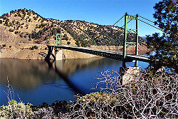
38°43′05"N 123°00′34"W | 381,000 | 0.470 | Warm Springs Dam | Dry Creek | 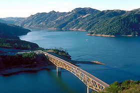 |
| Lake Nacimiento Lake Nacimiento Lake Nacimiento is an long lake on the Nacimiento River in northern San Luis Obispo County, California. The lake contains many arms including Snake Creek and Dip Creek, nearer the dam, and the central Las Tablas and Franklin Creeks. Because of the dragon-like shape created by the positions of... |
San Luis Obispo San Luis Obispo County, California San Luis Obispo County is a county located along the Pacific Ocean in the Central Coast of the U.S. state of California, between Los Angeles and the San Francisco Bay Area. As of the 2010 census its population was 269,637, up from 246,681 at the 2000 census... |
35°44′40"N 120°54′14"W | 378,480 | 0.467 | Nacimiento River Nacimiento River The Nacimiento River is a river in southern Monterey County and northern San Luis Obispo County, California. A large portion of the river's run is on military reservations... |
Nacimiento Dam | |
| Hetch Hetchy Reservoir Hetch Hetchy Reservoir Hetch Hetchy Reservoir is a reservoir in Yosemite National Park, about northeast from the city of Merced, California. The reservoir has a capacity of and is formed by the concrete gravity O'Shaughnessy Dam in Hetch Hetchy Valley on the Tuolumne River... |
Tuolumne Tuolumne County, California Tuolumne County is a county in the Sierra Nevada of the U.S. state of California. The northern half of Yosemite National Park is located in the eastern part of the county. As of the 2010 census, the population was 55,365, up from 54,501 at the 2000 census... |
37°56′21"N 119°43′32"W | 360,000 | 0.444 | Tuolumne River Tuolumne River The Tuolumne River is a California river that flows nearly from the central Sierra Nevada to the San Joaquin River in the Central Valley... |
O'Shaughnessy Dam O'Shaughnessy Dam The O'Shaughnessy Dam is a curved gravity dam on the Tuolumne River in the Hetch Hetchy Valley of California's Sierra Nevada. The dam is located in Yosemite National Park, and creates the Hetch Hetchy Reservoir. It is named for former San Francisco chief engineer and the original chief engineer of... |
 |
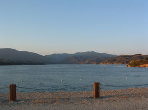
| Lake San Antonio Lake San Antonio Lake San Antonio is a lake in southern Monterey County, California. The lake is formed by an earthfill dam on the San Antonio River. The dam is 202 feet tall and was completed in 1965 under Monterey County District Engineer Loran Bunte Jr . The lake and dam are owned by the Monterey County Water... |
Monterey Monterey County, California Monterey County is a county located on the Pacific coast of the U.S. state of California, its northwestern section forming the southern half of Monterey Bay. The northern half of the bay is in Santa Cruz County. As of 2010, the population was 415,057. The county seat and largest city is Salinas... |
35°52′13"N 121°00′19"W | 335,000 | 0.413 | San Antonio River San Antonio River (California) The San Antonio River is a river in southern Monterey County, California.-Geography:The river travels southeast from its headwaters in the Santa Lucia Range in the Los Padres National Forest and into Lake San Antonio. This is a reservoir behind the San Antonio Dam, an earth-fill dam on the river... |
San Antonio Dam | |
| Castaic Lake Castaic Lake Castaic Lake is an artificial lake on Castaic Creek formed by Castaic Dam, in northwestern Los Angeles County, California, near the town of Castaic. The lake with a surface elevation of approximately above sea level is the terminus of the West Branch of the California Aqueduct, though some comes... |
Los Angeles Los Angeles County, California Los Angeles County is a county in the U.S. state of California. As of 2010 U.S. Census, the county had a population of 9,818,605, making it the most populous county in the United States. Los Angeles County alone is more populous than 42 individual U.S. states... |
34°31′12"N 118°36′23"W | 323,700 | 0.399 | Castaic Creek Castaic Creek Castaic Creek is a stream in northern Los Angeles County, California. It is a tributary of the Santa Clara River.-Castaic Lake:Castaic Dam on the creek forms Castaic Lake, but most of the water comes from the West Branch of the California Aqueduct, also called the State Water Project. The lake is... |
Castaic Dam Castaic Dam Castaic Dam is a dam near the city of Castaic, California. It is an earth-fill dam, though its surfaces are covered with boulders and cobble-sized rocks to prevent erosion. Although located on Castaic Creek and forming Castaic Lake, Castaic Creek provides little of its water. The lake is the... |
 |
| New Hogan Lake New Hogan Lake New Hogan Lake is an artificial lake in the foothills of the Sierra Nevada in Calaveras County, California, about northeast of Stockton. It is formed by New Hogan Dam on the Calaveras River, whose North and South forks combine just upstream of the lake, and has a capacity of . The lake has a... |
Calaveras Calaveras County, California Calaveras County is a county located in the Gold Country of the U.S. state of California. Calaveras is the Spanish word for skulls; the county was reportedly named for the remains of Native Americans discovered by the Spanish explorer Captain Gabriel Moraga. As of the 2010 census, the county had a... |
38°09′03"N 120°48′47"W | 317,000 | 0.391 | Calaveras River Calaveras River The Calaveras River is a river in the California Central Valley. It flows roughly southwest for from the confluence of its north and south forks in Calaveras County to its confluence with the San Joaquin River just west of the city of Stockton.... |
New Hogan Dam New Hogan Dam New Hogan Dam is an embankment dam on the Calaveras River, a tributary of the San Joaquin River in central California. The dam lies east of Rancho Calaveras and impounds New Hogan Lake in the foothills of the Sierra Nevada. Built by the U.S. Army Corps of Engineers , the -high dam was completed in... |
|
| Prado Flood Control Basin Prado Reservoir Prado Reservoir is a reservoir in northwestern Riverside County and southwestern San Bernardino County, a couple of miles west of the city of Corona, in the U.S. state of California. The reservoir has a capacity of and is formed by Prado Dam on the Santa Ana River. The dam is composed of... |
Riverside Riverside County, California Riverside County is a county in the U.S. state of California. One of 58 California counties, it covers in the southern part of the state, and stretches from Orange County to the Colorado River, which forms the state border with Arizona. The county derives its name from the city of Riverside,... |
33°54′33"N 117°37′07"W | 314,400 | 0.389 | Santa Ana River Santa Ana River The Santa Ana River is the largest river of Southern California in the United States. Its drainage basin spans four counties. It rises in the San Bernardino Mountains and flows past the cities of San Bernardino and Riverside, before cutting through the northern tip of the Santa Ana Mountains and... |
Prado Dam Prado Dam Prado Dam is an earth-fill dam across the Santa Ana River at the Chino Hills near Corona, California in Riverside County with the resulting impounded water creating Prado Flood Control Basin reservoir. The U.S. Army Corps of Engineers built the dam in Lower Santa Ana River Canyon... |
|
| Clear Lake | Lake Lake County, California Lake County is a county located in the north central portion of the U.S. state of California, north of the San Francisco Bay Area. It takes its name from Clear Lake, the dominant geographic feature in the county and the largest natural lake wholly within California... |
39°03′42"N 122°49′38"W | 313,000 | 0.386 | Cache Creek Cache Creek Cache Creek may refer to:*Cache Creek , a stream in the Thompson Country of British Columbia, Canada*Cache Creek, British Columbia, a town in British Columbia, Canada, named after the creek... |
Cache Creek Dam | |
| Indian Valley Reservoir Indian Valley Reservoir Indian Valley Reservoir is a manmade lake in Lake County, California, west of Williams near State Route 20.The capacity reservoir was created by the construction of the Indian Valley Dam across the north fork of Cache Creek in 1975... |
Lake Lake County, California Lake County is a county located in the north central portion of the U.S. state of California, north of the San Francisco Bay Area. It takes its name from Clear Lake, the dominant geographic feature in the county and the largest natural lake wholly within California... |
39°07′31"N 122°32′34"W | 300,600 | 0.371 | North Fork Cache Creek | Indian Valley Dam | |
| Cherry Lake | Tuolumne Tuolumne County, California Tuolumne County is a county in the Sierra Nevada of the U.S. state of California. The northern half of Yosemite National Park is located in the eastern part of the county. As of the 2010 census, the population was 55,365, up from 54,501 at the 2000 census... |
38°00′20"N 119°54′25"W | 274,300 | 0.338 | Cherry Creek Cherry Creek (California) Cherry Creek is a swift-moving stream in the Sierra Nevada in eastern California, USA. It is a part of the watershed in the Emigrant Wilderness that drains into the Tuolumne River. At its headwaters, it flows through granite valleys similar to those found in Yosemite Valley, though these areas are... |
Cherry Valley Dam | |
| Lake Casitas Lake Casitas Lake Casitas is an artificial lake in the Los Padres National Forest of Ventura County, California, created by the construction of Casitas Dam on Coyote Creek, two miles before it joins the Ventura River. Santa Ana Creek and North Fork Coyote Creek also flow into the lake. The dam was constructed... |
Ventura Ventura County, California Ventura County is a county in the southern part of the U.S. state of California. It is located on California's Pacific coast. It is often referred to as the Gold Coast, and has a reputation of being one of the safest populated places and one of the most affluent places in the country... |
34°23′09"N 119°20′08"W | 254,000 | 0.313 | Coyote Creek Coyote Creek (Ventura County) Coyote Creek is a stream in Ventura County, California, United States which feeds Lake Casitas. It is a major tributary of the Ventura River.... |
Casitas Dam Casitas Dam Casitas Dam is an earthfill dam across Coyote Creek that forms Lake Casitas in the Los Padres National Forest of Ventura County, California near Ojai, California. The dam is located two miles above the junction of Coyote Creek and the Ventura River. Water from the Ventura River is diverted to Lake... |
|
| Whiskeytown Lake Whiskeytown Lake Whiskeytown Lake is a lake in Shasta County in northwestern California, about west of Redding. The lake is in the Whiskeytown Unit of the Whiskeytown-Shasta-Trinity National Recreation Area. It has a capacity of and is formed by Whiskeytown Dam on Clear Creek... |
Shasta Shasta County, California Shasta County is a county located in the northern portion of the U.S. state of California. The county occupies the northern reaches of the Sacramento Valley, with portions extending into the southern reaches of the Cascade Range. As of the 2010 census, the population was 177,223, up from 163,256... |
40°37′41"N 122°33′51"W | 241,100 | 0.297 | Clear Creek | Whiskeytown Dam | 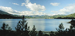 |
| Union Valley Reservoir Union Valley Reservoir Union Valley Reservoir is a reservoir in eastern El Dorado County, California, about northeast of Placerville. The lake is in El Dorado National Forest in the Sierra Nevada at an elevation of . It was formed in 1963 by the high earth and rockfill Union Valley Dam on Silver Creek, which is a... |
El Dorado El Dorado County, California El Dorado County is a county located in the historic Gold Country in the Sierra Nevada Mountains and foothills of the U.S. state of California. The 2010 population was 181,058. The El Dorado county seat is in Placerville.... |
38°52′35"N 120°24′00"W | 230,000 | 0.284 | Silver Creek | Union Valley Dam | |
| Stampede Reservoir | Sierra Sierra County, California Sierra County is a county located in the Sierra Nevada of the U.S. state of California, northeast of Sacramento on the border with Nevada. As of the 2010 census the population was 3,240, down from 3,555 at the 2000 census. The county seat is Downieville.... |
39°28′38"N 120°08′26"W | 226,500 | 0.279 | Little Truckee River Little Truckee River The Little Truckee River is a river that is a tributary to its larger counterpart, the Truckee River, located in Nevada County in eastern California.-Description:... |
Stampede Dam | |
| Twitchell Reservoir Twitchell Reservoir Twitchell Reservoir is a reservoir in southern San Luis Obispo County and northern Santa Barbara County in California. The reservoir has a capacity of and is formed by Twitchell Dam on the Cuyama River about from its headwaters in the Chumash Wilderness Area and about from its confluence with... |
Santa Barbara Santa Barbara County, California Santa Barbara County is a county located in the southern portion of the U.S. state of California, on the Pacific coast. As of 2010 the county had a population of 423,895. The county seat is Santa Barbara and the largest city is Santa Maria.-History:... , San Luis Obispo San Luis Obispo County, California San Luis Obispo County is a county located along the Pacific Ocean in the Central Coast of the U.S. state of California, between Los Angeles and the San Francisco Bay Area. As of the 2010 census its population was 269,637, up from 246,681 at the 2000 census... |
35°00′44"N 120°18′25"W | 224,300 | 0.277 | Cuyama River Cuyama River The Cuyama River is a river in southern San Luis Obispo County, northern Santa Barbara County, and northern Ventura County, in the U.S. state of California. It joins the Sisquoc River forming the Santa Maria River... |
Twitchell Dam | |
| Pardee Reservoir | Amador Amador County, California Amador County is a county located in the Sierra Nevada of the U.S. state of California. As of the 2010 census, the population was 38,091. The county seat is Jackson.Amador County bills itself as "The Heart of the Mother Lode" and lies within the Gold Country... , Calaveras Calaveras County, California Calaveras County is a county located in the Gold Country of the U.S. state of California. Calaveras is the Spanish word for skulls; the county was reportedly named for the remains of Native Americans discovered by the Spanish explorer Captain Gabriel Moraga. As of the 2010 census, the county had a... |
38°15′27"N 120°51′01"W | 209,950 | 0.259 | Mokelumne River Mokelumne River The Mokelumne River is a river in Northern California. The Upper Mokelumne River originates in the Sierra Nevada mountain range and flows into Pardee Reservoir and then Camanche Reservoir in the Sierra foothills. The Lower Mokelumne River refers to the portion of the river below Camanche Dam... |
Pardee Dam Pardee Dam Pardee Dam is a -high structure across the Mokelumne River which marks the boundary between Amador and Calaveras Counties, in the foothills of the Sierra Nevada approximately about northeast of Stockton.... |
|
| Hell Hole Reservoir Hell Hole Reservoir Hell Hole reservoir is an artificial, crescent-shaped lake in the Sierra Nevada mountain range west of Lake Tahoe in California. The lake is about long when at full capacity.... |
Placer Placer County, California Placer County is a county located in both the Sacramento Valley and Sierra Nevada regions of the U.S. state of California, in what is known as the Gold Country. It stretches from the suburbs of Sacramento to Lake Tahoe and the Nevada border. Because of the expansion of the Greater Sacramento,... |
39°03′33"N 120°24′35"W | 208,400 | 0.257 | Rubicon River Rubicon River (California) The Rubicon River is a river in the Sierra Nevada of northern California, west of Lake Tahoe. It is a tributary of the Middle Fork American River, and is long and with a watershed of about . The river's headwaters are in the Crystal Range of the Sierra Nevada, within the Eldorado National Forest's... |
Hell Hole Dam |  |
| Lake Cachuma Lake Cachuma Lake Cachuma is an artificial lake located in the Santa Ynez Valley of central Santa Barbara County, California on the Santa Ynez River adjoining the north side of California State Route 154. The reservoir was created by the construction of Bradbury Dam, a earth-fill structure built by the U.S.... |
Santa Barbara Santa Barbara County, California Santa Barbara County is a county located in the southern portion of the U.S. state of California, on the Pacific coast. As of 2010 the county had a population of 423,895. The county seat is Santa Barbara and the largest city is Santa Maria.-History:... |
34°35′12"N 119°58′52"W | 205,000 | 0.253 | Santa Ynez River Santa Ynez River The Santa Ynez River is one of the largest rivers on the Central Coast of California. It is long, flowing from east to west through the Santa Ynez Valley, reaching the Pacific Ocean at Surf, near Vandenberg Air Force Base and the city of Lompoc.... |
Bradbury Dam Bradbury Dam Bradbury Dam is an earthen dam across the Santa Ynez River in central Santa Barbara County, California. The dam forms Lake Cachuma, which provides the majority of water supplies within the county.... |
|