

Isabella Dam
Encyclopedia
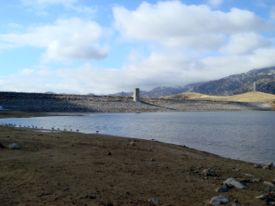
Isabella Dam is an embankment dam
located about halfway down the Kern River
, between the towns of Kernville
and Lake Isabella
in Kern County, California
. Isabella Dam serves agricultural, hydroelectric, and flood control
uses.
to prevent flooding of Bakersfield. The city had been flooded in 1867 and 1893. In 1950, while the dam was under construction, they experienced flooding measuring 30000 cubic feet (849.5 m³) of water per second. The dam was completed in March of 1953.
. Normal release from the main dam is 3,000 cubic feet per second (80 m³/s), maximum historical releases were 7,200 ft³/s (200 m³/s) in 1983.
The auxiliary dam is part of the Borel hydroelectric project. The canal for the Borel project diverts water from 5.5 miles (8.9 km) upstream of Isabella Dam.
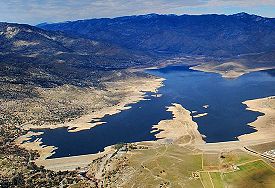
The reservoir that Isabella Dam creates is called Lake Isabella
. Water from Lake Isabella can be used in any of three ways. It is released into the Lower Kern River from the main dam, through the hydroelectric project in the main dam, or through the hydroelectric project in the auxiliary dam. The design capacity of the release channel (the Lower Kern River) is over 8,000 ft³/s (230 m³/s). If Lake Isabella is above 110000 acre.ft, the water can also be diverted into the Borel project at the main dam.
 As of April 28, 2006, a seepage problem was found in the Isabella Auxiliary Dam. Officials determined that it would be necessary to restrict the maximum reservoir elevation to 20 feet (6.1 m) below the spillway, or normal "full" pool. The dam's releases through the outlet were increased, allowing the water to flow at 4,500 ft³/s (130 m³/s).
In May 2006, due to more than average rainfall and snow
pack in the mountains, and warmer than average temperatures in the area, the Upper Kern River was filling Lake Isabella faster than officials could lower it. The Lower Kern River was also running higher than normal, and flowing at up to 20 miles per hour (32.2 km/h) in some parts. State Route 178
, which travels through the canyon between Bakersfield and Lake Isabella, became unstable, and one lane was closed due to the high water levels. Some flooding was reported by property owners along the river. Emergency management officials warned that if Isabella Dam were to fail when the reservoir was full, a large part of Bakersfield would be inundated within 2 to 4 hours.
After the news of the seepage, the dam came under further attention due to being situated on a fault line. The fault line
was thought to be inactive, but in February 2007, a study by the U.S. Army Corps of Engineers found evidence of at least one earthquake
in the last 5,000 years, and therefore judged the fault line as active. With the new information about the fault line, the study said the dam was not likely to be in danger. On November 9, 2007, the Corps of Engineers released the Isabella Dam Consensus Report, that confirmed the high-risk classification of the dam, ranking Isabella Dam among the 6 highest risk and highest priority dams in America, and later elevated it to the highest priority.
On March 12, 2008, local officials brought in a team of emergency response experts, and began work on an evacuation plan in case Isabella Dam were to fail.
Embankment dam
An embankment dam is a massive artificial water barrier. It is typically created by the emplacement and compaction of a complex semi-plastic mound of various compositions of soil, sand, clay and/or rock. It has a semi-permanent waterproof natural covering for its surface, and a dense, waterproof...
located about halfway down the Kern River
Kern River
The Kern River is a river in the U.S. state of California, approximately long. It drains an area of the southern Sierra Nevada mountains northeast of Bakersfield. Fed by snowmelt near Mount Whitney, the river passes through scenic canyons in the mountains and is a popular destination for...
, between the towns of Kernville
Kernville, California
Kernville is a census-designated place in the southern Sierra Nevadas, in Kern County, California, United States. Kernville is located northeast of Bakersfield, at an elevation of 2667 feet...
and Lake Isabella
Lake Isabella, California
Lake Isabella is a census-designated place in the southern Sierra Nevadas, in Kern County, California, United States, located near Lake Isabella. Lake Isabella is located east-northeast of Bakersfield, at an elevation of 2513 feet...
in Kern County, California
California
California is a state located on the West Coast of the United States. It is by far the most populous U.S. state, and the third-largest by land area...
. Isabella Dam serves agricultural, hydroelectric, and flood control
Flood control
In communications, flood control is a feature of many communication protocols designed to prevent overwhelming of a destination receiver. Such controls can be implemented either in software or in hardware, and will often request that the message be resent after the receiver has finished...
uses.
History
In 1948, Congress appropriated funds to build a damDam
A dam is a barrier that impounds water or underground streams. Dams generally serve the primary purpose of retaining water, while other structures such as floodgates or levees are used to manage or prevent water flow into specific land regions. Hydropower and pumped-storage hydroelectricity are...
to prevent flooding of Bakersfield. The city had been flooded in 1867 and 1893. In 1950, while the dam was under construction, they experienced flooding measuring 30000 cubic feet (849.5 m³) of water per second. The dam was completed in March of 1953.
Construction
Isabella Dam actually consists of two dams, a "main dam", and an “auxiliary dam”. The main dam is of earthen build, 1695 feet (516.6 m) long and 98 feet (29.9 m) tall, and owned and maintained by the U.S. Army Corps of EngineersUnited States Army Corps of Engineers
The United States Army Corps of Engineers is a federal agency and a major Army command made up of some 38,000 civilian and military personnel, making it the world's largest public engineering, design and construction management agency...
. Normal release from the main dam is 3,000 cubic feet per second (80 m³/s), maximum historical releases were 7,200 ft³/s (200 m³/s) in 1983.
The auxiliary dam is part of the Borel hydroelectric project. The canal for the Borel project diverts water from 5.5 miles (8.9 km) upstream of Isabella Dam.
The reservoir that Isabella Dam creates is called Lake Isabella
Lake Isabella
Lake Isabella is a reservoir in Kern County, California created by the earthen Isabella Dam. It was formed in 1953 when the U.S. Army Corps of Engineers dammed the Kern River at the junction of its two forks at Whiskey Flat. At 11,000 acres , it is one of the larger reservoirs in California...
. Water from Lake Isabella can be used in any of three ways. It is released into the Lower Kern River from the main dam, through the hydroelectric project in the main dam, or through the hydroelectric project in the auxiliary dam. The design capacity of the release channel (the Lower Kern River) is over 8,000 ft³/s (230 m³/s). If Lake Isabella is above 110000 acre.ft, the water can also be diverted into the Borel project at the main dam.
2006 seepage
In May 2006, due to more than average rainfall and snow
Snow
Snow is a form of precipitation within the Earth's atmosphere in the form of crystalline water ice, consisting of a multitude of snowflakes that fall from clouds. Since snow is composed of small ice particles, it is a granular material. It has an open and therefore soft structure, unless packed by...
pack in the mountains, and warmer than average temperatures in the area, the Upper Kern River was filling Lake Isabella faster than officials could lower it. The Lower Kern River was also running higher than normal, and flowing at up to 20 miles per hour (32.2 km/h) in some parts. State Route 178
California State Route 178
State Route 178 is a route that exists in two constructed segments. The gap in between segments is connected by various local roads and State Route 190 through Death Valley National Park....
, which travels through the canyon between Bakersfield and Lake Isabella, became unstable, and one lane was closed due to the high water levels. Some flooding was reported by property owners along the river. Emergency management officials warned that if Isabella Dam were to fail when the reservoir was full, a large part of Bakersfield would be inundated within 2 to 4 hours.
After the news of the seepage, the dam came under further attention due to being situated on a fault line. The fault line
Fault line
In geology, fault line refers to the surface trace of a fault.Fault line, Fault Line, or faultline may also refer to:* "Faultline", a song from the 2008 studio album Versus by The Haunted...
was thought to be inactive, but in February 2007, a study by the U.S. Army Corps of Engineers found evidence of at least one earthquake
Earthquake
An earthquake is the result of a sudden release of energy in the Earth's crust that creates seismic waves. The seismicity, seismism or seismic activity of an area refers to the frequency, type and size of earthquakes experienced over a period of time...
in the last 5,000 years, and therefore judged the fault line as active. With the new information about the fault line, the study said the dam was not likely to be in danger. On November 9, 2007, the Corps of Engineers released the Isabella Dam Consensus Report, that confirmed the high-risk classification of the dam, ranking Isabella Dam among the 6 highest risk and highest priority dams in America, and later elevated it to the highest priority.
On March 12, 2008, local officials brought in a team of emergency response experts, and began work on an evacuation plan in case Isabella Dam were to fail.
External links
- Lakes Online - Lake Isabella Dam Information
- Kern River Valley Revitalization KRVR.org - Lake Isabella Dam Safety Forum
- U.S. Army Corps of Engineers, Isabella Dam Situation Report, November 7, 2008
- Kern County Superintendent of Schools GIS, Lake Isabella Dam Burst Map1, July 2, 2007