

List of lakes in Oregon
Encyclopedia
This is an incomplete list of the lake
s and reservoir
s of Oregon
.
Lake
A lake is a body of relatively still fresh or salt water of considerable size, localized in a basin, that is surrounded by land. Lakes are inland and not part of the ocean and therefore are distinct from lagoons, and are larger and deeper than ponds. Lakes can be contrasted with rivers or streams,...
s and reservoir
Reservoir
A reservoir , artificial lake or dam is used to store water.Reservoirs may be created in river valleys by the construction of a dam or may be built by excavation in the ground or by conventional construction techniques such as brickwork or cast concrete.The term reservoir may also be used to...
s of Oregon
Oregon
Oregon is a state in the Pacific Northwest region of the United States. It is located on the Pacific coast, with Washington to the north, California to the south, Nevada on the southeast and Idaho to the east. The Columbia and Snake rivers delineate much of Oregon's northern and eastern...
.
| Name | Description |
|---|---|
| Lake Abert Lake Abert Lake Abert is a large, shallow, alkali lake in Lake County, Oregon, United States. It is approximately long and wide at its widest point. It is located northwest of the small, unincorporated community of Valley Falls, Oregon. The lake was named in honor of Colonel John James Abert by explorer... |
in central Lake County Lake County, Oregon Lake County is a county in the high desert south central region of the U.S. state of Oregon, so named for the many lakes found within its boundaries, including Lake Abert, Hart Lake Reservoir, and Goose Lake. While Lake is among Oregon's largest counties, it is sparsely populated with 7,895... |
| Agate Lake Agate Lake Agate Lake is a reservoir located above sea level in Jackson County, Oregon, United States. It is northeast of Medford,just north of Roxy Ann Peak... |
an impoundment of Dry Creek |
| Agency Lake | connected to Upper Klamath Lake Upper Klamath Lake Upper Klamath Lake is a large, shallow freshwater lake east of the Cascade Range in south central Oregon in the United States. The largest freshwater body in Oregon, it is approximately 20 mi long and 8 mi wide and extends northwest from the city of Klamath Falls... |
| Alvord Lake Alvord Lake (Oregon) Alvord Lake is a seasonal shallow alkali lake in Harney County of the U.S. state of Oregon. Its elevation is . It is located about southeast of Alvord Desert in the Alvord Basin and serves as terminus for all its streams. Its water level varies from dry to several feet deep... |
a terminus for streams near Alvord Desert Alvord Desert The Alvord Desert is a desert located in Harney County, in southeastern Oregon in the western United States. It is roughly southeast of Steens Mountain. The Alvord Desert is a dry lake bed and averages of rain a year. Two mountain ranges separate it from the Pacific Ocean—the Coast Range, and... |
| Aneroid Lake Aneroid Lake Aneroid Lake is a large tarn located on Aneroid Mountain in the Eagle Cap Wilderness of Northeastern Oregon. It is situated in between Roger Lake and Dollar Lake. It is not accessible by any kind of motor vehicle. However, there is a popular hiking trail that leads to the lake. There is a small... |
in Eagle Cap Wilderness |
| Antelope Reservoir | near Jordan Valley Jordan Valley, Oregon Jordan Valley is a city in Malheur County, Oregon, United States. It is part of the Ontario, OR–ID Micropolitan Statistical Area. The city was named after Jordan Creek, a tributary of Owyhee River, which runs through the city; the creek is named for a 19th century prospector, Michael M. Jordan... |
| Anthony Lakes Anthony Lakes (Oregon) Anthony Lakes are a group of about 15 lakes and marshes in the Blue Mountains of northeastern Oregon, U.S.The group contains Grande Ronde Lake, Mud Lake, Floodwater Flats, Anthony Lake, Lilypad Lake, Hoffer Lakes, and several unnamed marshes and shallow lakes.- References :... |
in the Elkhorn Mountains, also known as North Powder Lakes |
| Applegate Lake Applegate Lake Applegate Lake is a 988-acre reservoir located approximately from Jacksonville, Oregon, United States, and south of Applegate, Oregon, along Upper Applegate Road. The lake is an impoundment of the Applegate River.... |
a flood control reservoir on the Applegate River Applegate River The Applegate River is a long tributary of the Rogue River in the U.S. state of Oregon. It drains approximately . Rising in northern California, it soon crosses the border and flows northeast then northwest to meet the Rogue about west of Grants Pass... |
| Aspen Lake Aspen Lake Aspen Lake is a swampy lake in the Southern Cascade Range, just west of Klamath Falls, Oregon, United States. It is about in area and located at in altitude off Aspen Rd, from the junction of Oregon Route 140 with Oregon Route 62 at White City, Oregon.... |
in the Southern Cascade Range Cascade Range The Cascade Range is a major mountain range of western North America, extending from southern British Columbia through Washington and Oregon to Northern California. It includes both non-volcanic mountains, such as the North Cascades, and the notable volcanoes known as the High Cascades... , just west of Klamath Falls Klamath Falls, Oregon Klamath Falls is a city in Klamath County, Oregon, United States. Originally called Linkville when George Nurse founded the town in 1867, after the Link River on whose falls this city sat, although no falls currently exist; the name was changed to Klamath Falls in 1892... |
| Baert Lake | a man-made lake in Christmas Valley Christmas Valley, Oregon Christmas Valley is an unincorporated community in Lake County, Oregon, United States. The community was named after nearby dry Christmas Lake, east of the present townsite and the site of the former Lake post office, which ran from 1906 until 1943. Real estate development around a planned... |
| Lake Billy Chinook | an impoundment of the Crooked Crooked River (Oregon) The Crooked River is a tributary, long, of the Deschutes River in the U.S. state of Oregon. The river begins at the confluence of South Fork Crooked River and Beaver Creek. Of the two tributaries, the South Fork Crooked River is the larger and is sometimes considered part of the Crooked River proper... , Deschutes, and Metolius Metolius River The Metolius River is a tributary of the Deschutes River in Central Oregon, United States, near the city of Sisters. The river flows north from springs near Black Butte, then turns sharply east, descending through a series of gorges before ending in the western end of the lake... rivers by the Round Butte Dam Round Butte Dam Round Butte Dam is a rockfill-type hydroelectric dam on the Deschutes River, in the U.S. state of Oregon. It is located in Jefferson County. Its reservoir is called Lake Billy Chinook.-References:... near The Cove Palisades State Park The Cove Palisades State Park The Cove Palisades State Park is a state park in eastern Jefferson County, Oregon, near Culver and Madras in the central part of the state, and is administered by the Oregon Parks and Recreation Department... |
| Big Cliff Reservoir | A re-regulation reservoir below Detroit Lake Detroit Lake Detroit Lake is a reservoir impounded by the Detroit Dam on the North Santiam River southeast of Salem, Oregon, United States.The lake is adjacent to Oregon Route 22 near the city of Detroit.... |
| Blue Lake Blue Lake Regional Park Blue Lake Regional Park is a public park in Fairview, in the U.S. state of Oregon. The park, near the south shore of the Columbia River in Multnomah County, includes many covered and uncovered picnic areas, playing fields for sports such as softball, and infrastructure related to lake recreation... |
a recreational lake in Fairview Fairview, Oregon As of the census of 2000, there were 7,561 people, 2,831 households, and 1,936 families residing in the city. The population density was 2,360.8 people per square mile . There were 3,116 housing units at an average density of 972.9 per square mile... |
| Blue River Reservoir Blue River Reservoir Blue River Reservoir is a man-made reservoir in the Willamette National Forest in Lane County, Oregon, United States, built for flood control and irrigation. Despite its heavy recreational use, it is a common site for blue-green algae. Trout are the principal fish, supplemented with rainbow trout... |
an impoundment of the Blue River Blue River (Oregon) Blue River is a river in Lane County of the U.S. state of Oregon. It joins the McKenzie River near the community of Blue River, Oregon. The river was named for the striking blue color that apparently comes from its rocky bed.... , a tributary of the McKenzie River McKenzie River The McKenzie River is a tributary of the Willamette River in western Oregon in the United States. It drains part of the Cascade Range east of Eugene and flows into the southernmost end of the Willamette Valley. It is named for Donald MacKenzie, a Scottish Canadian fur trader... |
| Lake Bonneville Lake Bonneville (Oregon) Lake Bonneville is a reservoir on the Columbia River in the U.S. states of Oregon and Washington. It was created in 1937 with the construction of Bonneville Dam. The reservoir stretches between it and The Dalles Dam, upstream. It lies in parts of three counties in Oregon and two in Washington .... |
an impoundment on the Columbia River Columbia River The Columbia River is the largest river in the Pacific Northwest region of North America. The river rises in the Rocky Mountains of British Columbia, Canada, flows northwest and then south into the U.S. state of Washington, then turns west to form most of the border between Washington and the state... formed by Bonneville Dam Bonneville Dam Bonneville Lock and Dam consists of several run-of-the-river dam structures that together complete a span of the Columbia River between the U.S. states of Oregon and Washington at River Mile 146.1. The dam is located east of Portland, Oregon, in the Columbia River Gorge. The primary functions of... |
| Bonny Lakes Bonny Lakes Bonny Lakes are two small, shallow, mountain ponds located in the Eagle Cap Wilderness of Northeastern Oregon, United States. They are positioned in a large meadow on Aneroid Mountain known as Bonny Lakes basin, which is about two miles east of Dollar Lake... |
two ponds in Eagle Cap Wilderness |
| Borax Lake Borax Lake (Oregon) Borax Lake is a small alkali lake in the arid Pueblo Valley of southeastern Oregon, United States near Fields, Oregon. The lake is fed by an underground geothermal well with a temperature of around 190°C. The lake contains high concentrations of sodium borate and arsenic, the latter fatal to... |
alkali lake in Harney County, home to the Borax Lake chub Borax Lake chub The Borax Lake chub Gila boraxobius is a rare cyprinid fish found only in outflows and pools around Borax Lake, a small lake of the Alvord basin, Harney County, Oregon.... |
| Breitenbush Lake | straddles the Cascade Crest in Warm Springs Reservation and headwaters of some of the Breitenbush River Breitenbush River The Breitenbush River is a tributary of the North Santiam River in western Oregon in the United States. It drains a rugged, forested area of the Cascade Range east of Salem.... |
| A lake that lays in the Rouge-Umpqua Divide Wilderness, near Fish Lake. It can be seen from Grasshopper Mountain. | |
| Bull Run Lake Bull Run Lake Bull Run Lake is a reservoir, an impoundment of the Bull Run River in the U.S. state of Oregon. Providing part of the primary drinking water supply for Portland, Oregon, it rates highly as an oligotrophic lake, a very clean source of water.... |
An impoundment of the Bull Run River Bull Run River (Oregon) The Bull Run River is a tributary of the Sandy River in the U.S. state of Oregon. Beginning at the lower end of Bull Run Lake in the Cascade Range, it flows generally west through the Bull Run Watershed Management Unit , a restricted area meant to protect the river and its tributaries from... NW of Mount Hood, Portland's primary drinking water source |
| Bully Creek Reservoir Bully Creek Reservoir Bully Creek Reservoir is a reservoir in Malheur County of the U.S. state of Oregon. It is an impoundment of Bully Creek, a tributary of the Malheur River.... |
An impoundment of Bully Creek, a tributary of the Malheur River |
| Burnt Lake Burnt Lake Burnt Lake is a lake in the Mount Hood National Forest in Oregon, USA. It is in the Sandy River watershed.... |
in the Sandy River Sandy River (Oregon) The Sandy River is a tributary of the Columbia River in northwestern Oregon in the United States. Measured by a United States Geological Survey gauge downstream of the Sandy's confluence with the Bull Run River, from the mouth, the river's average discharge is . The maximum daily recorded flow... watershed |
| Bybee Lake Smith and Bybee Wetlands Natural Area Smith and Bybee Wetlands Natural Area is a public park and nature reserve between the Columbia Slough and the Columbia River in Portland, Oregon. At about , it is one of the largest urban freshwater wetlands in the United States. Metro, the regional government for the Oregon part of the Portland... |
in the Columbia Slough Columbia Slough The Columbia Slough is a narrow waterway, about long, in the floodplain of the Columbia River in the U.S. state of Oregon. From its source in the Portland suburb of Fairview, the Columbia Slough meanders west through Gresham and Portland to the Willamette River, about from the Willamette's... watershed |
| Cabin Lake | a small seasonally dry lake southeast of Newberry Volcano Newberry Volcano Newberry Volcano is a large potentially active shield volcano located east of the Cascade Range and about southeast of Bend, Oregon. It is not a typical shield volcano. In addition to erupting basaltic lavas, it also has erupted andesitic and even rhyolitic lava.The volcano is in diameter and... and a popular place for birdwatching Birdwatching Birdwatching or birding is the observation of birds as a recreational activity. It can be done with the naked eye, through a visual enhancement device like binoculars and telescopes, or by listening for bird sounds. Birding often involves a significant auditory component, as many bird species are... |
| Camp Lake | a small lake at 6975 ft (2,126 m). elevation, northeast of South Sister mountain |
| Cascade Lakes Cascade Lakes The Cascade Lakes are a collection of lakes in central Oregon in the United States of America. They include Elk Lake, Hosmer Lake, Lava Lake, Cultus Lake, North and South Twin Lakes, as well as Crane Prairie Reservoir.... |
a group of mountain lakes south of Mount Bachelor Mount Bachelor Mount Bachelor, formerly named Bachelor Butte, is a stratovolcano atop a shield volcano in the Cascade Volcanic Arc and the Cascade Range of central Oregon.The Mount Bachelor ski area has operated on the mountain since 1958.... |
| Lake Celilo Lake Celilo Lake Celilo is a long reservoir on the Columbia River in the United States, between the U.S. states of Washington and Oregon. It was created in 1957 with the construction of The Dalles Dam near The Dalles, Oregon, and stretches upstream to the John Day Dam. Its filling drowned the former site of... |
an artificial lake of the Columbia River Columbia River The Columbia River is the largest river in the Pacific Northwest region of North America. The river rises in the Rocky Mountains of British Columbia, Canada, flows northwest and then south into the U.S. state of Washington, then turns west to form most of the border between Washington and the state... created by the The Dalles Dam |
| Christmas Lake | a seasonally dry lake in Christmas Valley Christmas Valley, Oregon Christmas Valley is an unincorporated community in Lake County, Oregon, United States. The community was named after nearby dry Christmas Lake, east of the present townsite and the site of the former Lake post office, which ran from 1906 until 1943. Real estate development around a planned... |
| Clear Lake Clear Lake (Oregon) Clear Lake may refer to one of several places in the U.S. state of Oregon:There are 11 bodies of water listed as of May 28, 2010.... |
name for at least ten Oregon lakes |
| Cooper Creek Reservoir | a tributary of the Umpqua River Umpqua River The Umpqua River on the Pacific coast of Oregon in the United States is approximately long. One of the principal rivers of the Oregon Coast and known for bass and shad, the river drains an expansive network of valleys in the mountains west of the Cascade Range and south of the Willamette Valley,... |
| Chickahominy Reservoir Chickahominy Reservoir Chickahominy Reservoir is located on U.S. Highway 20 east of Bend, Oregon and west of Burns, Oregon. It was built as an irrigation reservoir, but is now managed by Oregon Department of Fish and Wildlife as a recreational fishery... |
an impoundment of Chickahominy Creek near Riley Riley, Oregon Riley, Oregon is an unincorporated community in Harney County, Oregon, United States. The center of the community is at the crossroads of U.S. Highway 395 and U.S. Highway 20, milepost 104. Riley is about west of Burns, the seat of Harney County. The elevation of Riley is .Riley is farming and... |
| Cougar Reservoir Cougar Reservoir Cougar Reservoir is a reservoir on the South Fork McKenzie River in the U.S. state of Oregon. It is located in Lane County. It was created in 1964 with the construction of the hydroelectric Cougar Dam.... |
an impoundment of the McKenzie River McKenzie River The McKenzie River is a tributary of the Willamette River in western Oregon in the United States. It drains part of the Cascade Range east of Eugene and flows into the southernmost end of the Willamette Valley. It is named for Donald MacKenzie, a Scottish Canadian fur trader... created by Cougar Dam Cougar Dam Cougar Dam is a tall rockfill hydroelectric dam in the U.S. state of Oregon. It has a gated concrete spillway and a powerhouse with two turbines totaling 25 megawatts of electric power.... |
| Crane Prairie Reservoir Crane Prairie Reservoir Crane Prairie Reservoir is a man-made reservoir located about southwest of Bend, in Deschutes County, Oregon, United States, that also serves as one of Oregon's largest rainbow trout fisheries. It was so named because cranes often fish there. The dam was constructed in 1922 to prevent flooding to... |
A 5.34 square mile- (13.8 square km-) reservoir in Deschutes County and one of the largest rainbow trout fisheries in Oregon |
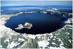
| Crater Lake Crater Lake Crater Lake is a caldera lake located in the south-central region of the U.S. state of Oregon. It is the main feature of Crater Lake National Park and famous for its deep blue color and water clarity. The lake partly fills a nearly deep caldera that was formed around 7,700 years agoby the... |
deepest lake in the Western Hemisphere and the seventh deepest in the world besides Lake Vostok Lake Vostok Lake Vostok is the largest of more than 140 subglacial lakes found under the surface of Antarctica. The overlying ice provides a continuous paleoclimatic record of 400,000 years, although the lake water itself may have been isolated for 15 to 25 million years. The lake is named after the... |
| Crescent Lake Crescent Lake (Oregon) Crescent Lake is a lake found on the eastern slope of the Cascade Mountains, in the northwest corner of Klamath County, Oregon, United States. The unincorporated community of Crescent Lake Junction on Oregon Route 58 and Crescent Lake State Airport are located to the northeast of the lake. The... |
north of the town of Chemult Chemult, Oregon Chemult is an unincorporated community in Klamath County, Oregon, United States, on U.S. Route 97. Chemult has a population of about 300 people. Chemult's elevation is .... |
| Cultus Lake Cultus Lake (Oregon) Cultus Lake is a lake in Deschutes County, Oregon. Formed by a glacier, it is located in the high Cascade Range in the Deschutes National Forest. The name is from the Chinook Jargon, and means variously bad or worthless, or simply "in vain".... |
central Oregon mountain lake in the Deschutes River watershed, and near the Cascade Lakes Scenic Byway Cascade Lakes Scenic Byway The Cascades Lakes Scenic Byway is a National Scenic Byway in central Oregon in the United States. It runs for in the rugged country of Deschutes and Klamath counties on the east side of the Cascade Range. It offers particularly good views of Mount Bachelor and provides access to many... |
| Davis Lake | A natural lake along the Cascade Lakes Scenic Byway Cascade Lakes Scenic Byway The Cascades Lakes Scenic Byway is a National Scenic Byway in central Oregon in the United States. It runs for in the rugged country of Deschutes and Klamath counties on the east side of the Cascade Range. It offers particularly good views of Mount Bachelor and provides access to many... |
| Detroit Lake Detroit Lake Detroit Lake is a reservoir impounded by the Detroit Dam on the North Santiam River southeast of Salem, Oregon, United States.The lake is adjacent to Oregon Route 22 near the city of Detroit.... |
impoundment of the Breitenbush River Breitenbush River The Breitenbush River is a tributary of the North Santiam River in western Oregon in the United States. It drains a rugged, forested area of the Cascade Range east of Salem.... and Santiam River Santiam River The Santiam River is a tributary of the Willamette River, about long, in western Oregon in the United States. Through its two principal tributaries, the North Santiam and the South Santiam rivers, it drains a large area of the Cascade Range at the eastern side of the Willamette Valley east of... by Detroit Dam Detroit Dam Detroit Dam was completed in 1953 by the U.S. Army Corp of Engineers on the North Santiam River between Linn County and Marion County, Oregon, in the Cascades... |
| Devils Lake | A small lake adjacent to the Cascade Lakes Scenic Byway Cascade Lakes Scenic Byway The Cascades Lakes Scenic Byway is a National Scenic Byway in central Oregon in the United States. It runs for in the rugged country of Deschutes and Klamath counties on the east side of the Cascade Range. It offers particularly good views of Mount Bachelor and provides access to many... |
| Devils Lake | source of the D River D River The D River is a river in Lincoln City, Oregon, United States. Proclaimed the "shortest river in the world" by the State of Oregon, it was listed in the Guinness World Records as the world's shortest river at . This title was lost in 1989 when Guinness named the Roe River in Montana as the world's... one of the shortest |
| Dexter Reservoir | also known as Dexter Lake Dexter Lake Dexter Reservoir is a reservoir in Lane County, Oregon, United States.It is on the Middle Fork Willamette River, and downriver from Lookout Point Lake. The communities of Dexter and Lowell are located next to the lake. Oregon Route 58 travels alongside its southern shore.... , an impoundment of the Middle Fork Willamette River Middle Fork Willamette River The Middle Fork Willamette River is one of several forks that unite to form the Willamette River in the western part of the U.S. state of Oregon... created by Dexter Dam |
| Diamond Lake Diamond Lake (Oregon) Diamond Lake is a lake in the southern part of the U.S. state of Oregon. It lies near the junction of Oregon Route 138 and Oregon Route 230 in the Umpqua National Forest in Douglas County. It is located between Mount Bailey to the west and Mount Thielsen to the east; it is just north of Crater Lake... |
about 10 mi (16.1 km) north of Crater Lake |
| Dollar Lake Dollar Lake (Wallowa County, Oregon) Dollar Lake is a small tarn located on Aneroid Mountain in the Eagle Cap Wilderness of Northeastern Oregon, United States. It is situated between Aneroid Lake and Bonny Lakes and rests one mile SW from Aneroid Peak. It likely received its name because of its size and its almost perfectly round... |
Eagle Cap Wilderness |
| Donaca Lake Donaca Lake Donaca Lake is a , deep lake in Linn County, Oregon, United States. It lies at an elevation of . The lake can be accessed via two different trails, one from the south and one from the north... |
Middle Santiam Wilderness |
| Dorena Reservoir Dorena Reservoir Dorena Reservoir is a reservoir on the Row River in Lane County, Oregon, United States. It is located east of Cottage Grove. Dorena Dam was completed in 1949.... |
an impoundment of the Willamette River Willamette River The Willamette River is a major tributary of the Columbia River, accounting for 12 to 15 percent of the Columbia's flow. The Willamette's main stem is long, lying entirely in northwestern Oregon in the United States... created by Cottage Grove Dam |
| East Lake | one of two crater lake Crater lake A crater lake is a lake that forms in a volcanic crater or caldera, such as a maar; less commonly and with lower association to the term a lake may form in an impact crater caused by a meteorite. Sometimes lakes which form inside calderas are called caldera lakes, but often this distinction is not... s in Newberry Caldera |
| E. E. Wilson Lake | |
| Elk Lake | A small lake located along the Cascade Lakes Scenic Byway Cascade Lakes Scenic Byway The Cascades Lakes Scenic Byway is a National Scenic Byway in central Oregon in the United States. It runs for in the rugged country of Deschutes and Klamath counties on the east side of the Cascade Range. It offers particularly good views of Mount Bachelor and provides access to many... |
| Emigrant Lake Emigrant Lake (Oregon) Emigrant Lake is a reservoir located southeast of Ashland, Oregon, at the southern end of the Rogue Valley.It has an elevation of above sea level.The lake has an average surface area of , and an average volume of .... |
an impoundment of Emigrant Creek |
| Lake Ewauna Lake Ewauna Lake Ewauna is a lake in Klamath Falls, Oregon, United States. It is the headwaters of the Klamath River. Fed by Link River from Upper Klamath Lake and controlled by the release of water from Keno Dam downstream, Lake Ewauna stays at a constant level throughout the year.At just over 6,500 feet ... |
headwaters of the Klamath River Klamath River The Klamath River is an American river that flows southwest through Oregon and northern California, cutting through the Cascade Range to empty into the Pacific Ocean. The river drains an extensive watershed of almost that stretches from the high desert country of the Great Basin to the temperate... |
| Fairview Lake Fairview Creek Fairview Creek is a tributary of the Columbia Slough in the U.S. state of Oregon. The creek forms in a wetland near Grant Butte in Gresham and flows north for to Fairview Lake in Fairview. Grant Butte, rising to above sea level, is one of eight dormant volcanic formations near Gresham... |
in the Columbia Slough Columbia Slough The Columbia Slough is a narrow waterway, about long, in the floodplain of the Columbia River in the U.S. state of Oregon. From its source in the Portland suburb of Fairview, the Columbia Slough meanders west through Gresham and Portland to the Willamette River, about from the Willamette's... watershed |
| Fern Ridge Reservoir Fern Ridge Reservoir Fern Ridge Reservoir is a reservoir on the Long Tom River in the U.S. state of Oregon. The reservoir is located approximately west of Eugene on Oregon Route 126. The reservoir is a U.S... |
also known as Fern Ridge Lake, an impoundment on the Long Tom River Long Tom River The Long Tom River is a tributary of the Willamette River in western Oregon in the United States. It drains an area at the south end of the Willamette Valley between Eugene and Corvallis.... |
| Fish Lake Fish Lake (Jackson County, Oregon) Fish Lake is a reservoir located above sea level in Jackson County, Oregon, United States. It is northeast of Medford.Originally a natural lake, it was enlarged by the tall Fish Lake Dam, which impounds the north fork of Little Butte Creek, in the Rogue River watershed.-Geology:Fish Lake is... |
Formerly a natural lake, now an impoundment of the north fork of Little Butte Creek Little Butte Creek (Rogue River) Little Butte Creek is a long tributary of the Rogue River located in the U.S. state of Oregon. Its drainage basin consists of approximately of Jackson County, and another in Klamath County. The north fork of the creek begins at Fish Lake, while the south fork begins near Brown Mountain. The two... |
| Fish Hawk Lake | Private Lake in Clatsop County near Birkenfeld |
| Flagstaff Lake | a part of the Hart Lake Basin complex of lakes in southeast Lake County Lake County, Oregon Lake County is a county in the high desert south central region of the U.S. state of Oregon, so named for the many lakes found within its boundaries, including Lake Abert, Hart Lake Reservoir, and Goose Lake. While Lake is among Oregon's largest counties, it is sparsely populated with 7,895... |
| Fossil Lake | a seasonally dry lake in northern Lake County Lake County, Oregon Lake County is a county in the high desert south central region of the U.S. state of Oregon, so named for the many lakes found within its boundaries, including Lake Abert, Hart Lake Reservoir, and Goose Lake. While Lake is among Oregon's largest counties, it is sparsely populated with 7,895... |
| Foster Reservoir Foster Reservoir Foster Reservoir is a reservoir created by Foster Dam on the South Santiam River near the city of Sweet Home, Oregon, United States. The reservoir is approximately 5.6 km long and contains approximately 494 ha when full. Primary use of the reservoir is recreation in the summer and flood... |
an impoundment on the South Santiam River South Santiam River The South Santiam River is a tributary of the Santiam River, about long, in western Oregon in the United States. It drains an area of the Cascade Range into the Willamette Valley east of Corvallis.... created by Foster Dam Foster Dam Foster Dam is an embankment type rock-fill dam across the South Santiam River near Sweet Home, Oregon, United States.Designed by the Corps of Engineers, it began service on August 22, 1968. Its primary purpose is flood control but it also provides power, navigation improvement downstream and... |
| Fourmile Lake Fourmile Lake Fourmile Lake is a reservoir located above sea level in Klamath County, Oregon, United States. It is northeast of Medford.... |
an impoundment of Fourmile Creek |
| Goose Lake Goose Lake (Oregon-California) Goose Lake is a large alkaline glacial lake located in the Goose Lake Valley on the Oregon-California border. The north end of the lake is in Lake County, Oregon and the south end is in Modoc County, California. The mountains at the north end of the lake are part of the Fremont National Forest... |
formerly headwaters of the Pit River Pit River The Pit River is a major river draining from northeastern California into the state's Central Valley. The Pit, the Klamath and the Columbia are the only three rivers in the U.S... |
| Green Peter Reservoir | an impoundment of the Middle Santiam River Middle Santiam River The Middle Santiam River is a tributary of the South Santiam River, long, in western Oregon in the United States. It drains a remote area of the Cascade Range east of Corvallis in the watershed of the Willamette River.... created by Green Peter Dam Green Peter Dam Green Peter Dam is a concrete gravity dam impounding the middle Santiam River in Linn County, Oregon. It was built to generate hydroelectricity, prevent flood damage, provide irrigation, and improve water quality downstream... |
| Guild's Lake Guild's Lake Guild's Lake was historically a flood-prone lowland near the confluence of Balch Creek with the Willamette River in the U.S. state of Oregon. Indigenous Multnomah people established villages on nearby Sauvie Island but not in the swampy area along the Balch Creek side of the river in what later... |
a lake formerly in NW Portland between NW Yeon and St. Helens Road |
| Lake Harriet Lake Harriet (Clackamas County, Oregon) Lake Harriet is a reservoir in Clackamas County of the U.S. state of Oregon.It is an impoundment of the Oak Grove Fork Clackamas River, located southeast of Portland and southwest of Government Camp.... |
an impoundment of the Oak Grove Fork Clackamas River Oak Grove Fork Clackamas River Oak Grove Fork Clackamas River is a tributary of the Clackamas River in the U.S. state of Oregon. From its headwaters in the Warm Springs Indian Reservation near Abbot Pass in the Cascade Range, the river flows generally west through Mount Hood National Forest in Clackamas County to the... |
| Hagg Lake | This 1200 acres (4.9 km²) reservoir is in the foothills of the Coast Range, just west of Forest Grove. |
| Harney Lake Harney Lake Harney Lake is a shallow alkali lake basin located in southeast Oregon, United States, approximately thirty miles south of the town of Burns. The lake lies within the boundary of the Malheur National Wildlife Refuge and is the lowest point in the Blitzen Valley drainage.- History :The lake has been... |
a natural, occasionally vanishing lake which merges with Malheur Lake Malheur Lake Malheur Lake is a lake in an arid region of eastern Oregon, United States near Burns, Oregon. The lake is fed by Donner und Blitzen River from the south and the Silvies River from the north. Malheur Lake has no outlet, though water escapes through ground seepage and by evaporation; widespread... in times of high water |
| Hells Canyon Reservoir | an impoundment of the Snake River Snake River The Snake is a major river of the greater Pacific Northwest in the United States. At long, it is the largest tributary of the Columbia River, the largest North American river that empties into the Pacific Ocean... |
| Henry Hagg Lake Henry Hagg Lake Henry Hagg Lake is an artificial lake in northwest Oregon, United States, which is an impoundment of Scoggins Creek which drains a small portion of the eastern side of Northern Oregon Coast Range. The lake and creek are part of the Tualatin River’s watershed in the Tualatin Valley... |
impoundment of Scoggins Creek Scoggins Creek Scoggins Creek, formerly known as Scoggin Creek, is a southeast-flowing stream in Washington County, Oregon, United States, named for pioneer Gustavus Scoggin. Surrounded by lava and basalt flows and layers of sandstone, it flows through the wide Scoggins Creek Valley to Henry Hagg Lake, impounded... and tributary of the Tualatin River Tualatin River The Tualatin River is a tributary of the Willamette River located in Oregon in the United States. The river is approximately long, and it drains a fertile farming region called the Tualatin Valley southwest and west of Portland at the northwest corner of the Willamette Valley... |
| Hills Creek Reservoir | an impoundment of the Middle Fork Willamette River Middle Fork Willamette River The Middle Fork Willamette River is one of several forks that unite to form the Willamette River in the western part of the U.S. state of Oregon... created by Hills Creek Dam |
| Howard Prairie Reservoir | an impoundment of Jenny Creek |
| Hyatt Reservoir Hyatt Reservoir Hyatt Reservoir is a reservoir in Jackson County, Oregon, United States, 20 miles east of Ashland. It is at an elevation of , and contains several fish species, such as bass, trout, bluegill, and crappie.There is also a winter resort nearby.... |
an impoundment of Keene Creek |
| Hosmer Lake | A small lake just off the Cascade Lakes Scenic Byway Cascade Lakes Scenic Byway The Cascades Lakes Scenic Byway is a National Scenic Byway in central Oregon in the United States. It runs for in the rugged country of Deschutes and Klamath counties on the east side of the Cascade Range. It offers particularly good views of Mount Bachelor and provides access to many... |
| John Boyle Reservoir | an impoundment on the upper Klamath River Klamath River The Klamath River is an American river that flows southwest through Oregon and northern California, cutting through the Cascade Range to empty into the Pacific Ocean. The river drains an extensive watershed of almost that stretches from the high desert country of the Great Basin to the temperate... formed by John C. Boyle Dam John C. Boyle Dam The John C. Boyle Dam is a hydroelectric dam located in southern Oregon, United States. It is on the upper Klamath River, south of Keno, and about 12 miles north of the California border. Originally developed and known as Big Bend, the John C... |
| Jubilee Lake | |
| Junipers Reservoir Junipers Reservoir Junipers Reservoir, also known as Muddy Creek Reservoir, is a man-made lake in Lake County, Oregon, United States, named for the junipers in the area. The reservoir is located south of Cottonwood Reservoir and west of Lakeview. There is forest to the north and agricultural land to the south. The... |
an artificial lake west of Lakeview Lakeview, Oregon Lakeview is a city in Lake County, Oregon, United States. The population was 2,294 at the 2010 census. It is the county seat of Lake County. Although it is an incorporated city, the municipal government refers to the community as "The Town of Lakeview", and bills itself as "Tallest Town in Oregon"... and the mouth of Lake County's Muddy Creek |
| Upper Klamath Lake Upper Klamath Lake Upper Klamath Lake is a large, shallow freshwater lake east of the Cascade Range in south central Oregon in the United States. The largest freshwater body in Oregon, it is approximately 20 mi long and 8 mi wide and extends northwest from the city of Klamath Falls... |
fed by the Williamson River (Oregon) Williamson River (Oregon) The Williamson River of south-central Oregon in the United States is about long. It drains about east of the Cascade Range. Together with its principal tributary, the Sprague River, it provides over half the inflow to Upper Klamath Lake, the largest freshwater lake in Oregon... , drained by the Link River Link River The Link River is a short river connecting Upper Klamath Lake to Lake Ewauna in the city of Klamath Falls in the U.S. state of Oregon. Draining a basin of , the river begins at the southern end of Klamath Lake and flows a short distance to the Link River Dam and continues to the head of Lake Ewauna... into Lake Ewauna Lake Ewauna Lake Ewauna is a lake in Klamath Falls, Oregon, United States. It is the headwaters of the Klamath River. Fed by Link River from Upper Klamath Lake and controlled by the release of water from Keno Dam downstream, Lake Ewauna stays at a constant level throughout the year.At just over 6,500 feet ... |
| Langdon Lake Langdon Lake (Oregon) Langdon Lake is reservoir located in the Umatilla National Forest of Northeastern Oregon, United States.It is an impoundment of Morning Creek,and the source of Lookingglass Creek, a tributary of the Grande Ronde River.... |
an impoundment of Morning Creek and source of Lookingglass Creek Lookingglass Creek Lookingglass Creek is a stream in the U.S. state of Oregon, located in Union County.... , a tributary of the Grande Ronde River Grande Ronde River The Grande Ronde River is a tributary of the Snake River, long, in northeastern Oregon and southeastern Washington in the United States. It drains an area southeast of the Blue Mountains and northwest of the Wallowa Mountains, on the Columbia Plateau... |
| Lava Lake | A small lake along the Cascade Lakes Scenic Byway Cascade Lakes Scenic Byway The Cascades Lakes Scenic Byway is a National Scenic Byway in central Oregon in the United States. It runs for in the rugged country of Deschutes and Klamath counties on the east side of the Cascade Range. It offers particularly good views of Mount Bachelor and provides access to many... |
| Leaburg Reservoir | an impoundment of the McKenzie River McKenzie River The McKenzie River is a tributary of the Willamette River in western Oregon in the United States. It drains part of the Cascade Range east of Eugene and flows into the southernmost end of the Willamette Valley. It is named for Donald MacKenzie, a Scottish Canadian fur trader... near Leaburg Leaburg, Oregon Leaburg is an unincorporated community in Lane County, Oregon, United States located on the McKenzie River and Oregon Route 126 east of Walterville and west of Vida.-History:... |
| Lemolo Lake Lemolo Lake Lemolo Lake is a small lake and reservoir located in Douglas County, Oregon in the Umpqua National Forest 30 miles north of Crater Lake National Park... |
and impoundment of the North Umpqua River Umpqua River The Umpqua River on the Pacific coast of Oregon in the United States is approximately long. One of the principal rivers of the Oregon Coast and known for bass and shad, the river drains an expansive network of valleys in the mountains west of the Cascade Range and south of the Willamette Valley,... about 10 miles north of Diamond Lake Diamond Lake (Oregon) Diamond Lake is a lake in the southern part of the U.S. state of Oregon. It lies near the junction of Oregon Route 138 and Oregon Route 230 in the Umpqua National Forest in Douglas County. It is located between Mount Bailey to the west and Mount Thielsen to the east; it is just north of Crater Lake... |
| Little Crater Lake | A tiny lake which about as deep as it is wide NE of Timothy Lake Timothy Lake Timothy Lake is a lake about southeast of Portland, Oregon, United States. It is in close proximity to Clear Lake and an impoundment of the Oak Grove Fork Clackamas River. The compacted-earth dam was built on Timothy Meadows in 1956 to regulate flow to Lake Harriet and the power plant was... |
| Little Cultus Lake Little Cultus Lake Little Cultus Lake is a natural lake in Deschutes County, Oregon, United States. Near its larger and more popular twin Cultus Lake to the north on the other side of Cultus Mountain, it is located in the Deschutes National Forest in the Cascade Range... |
A small lake located near the Cascade Lakes Scenic Byway Cascade Lakes Scenic Byway The Cascades Lakes Scenic Byway is a National Scenic Byway in central Oregon in the United States. It runs for in the rugged country of Deschutes and Klamath counties on the east side of the Cascade Range. It offers particularly good views of Mount Bachelor and provides access to many... |
| Little Lava Lake Little Lava Lake Little Lava Lake is located about southwest of Bend, Oregon, United States. The lake is approximately in size and has a maximum depth of about . The lake lies at the elevation of . The lake lies about a half mile south of Big Lava Lake. The lake has a small forest service campground and a... |
A small lake located at the head of the Deschutes River and near the Cascade Lakes Scenic Byway Cascade Lakes Scenic Byway The Cascades Lakes Scenic Byway is a National Scenic Byway in central Oregon in the United States. It runs for in the rugged country of Deschutes and Klamath counties on the east side of the Cascade Range. It offers particularly good views of Mount Bachelor and provides access to many... |
| Lookout Point Reservoir | an impoundment of the Middle Fork Willamette River Middle Fork Willamette River The Middle Fork Willamette River is one of several forks that unite to form the Willamette River in the western part of the U.S. state of Oregon... by Lookout Point Dam Lookout Point Dam Lookout Point Dam is an earth-type dam on the Middle Fork Willamette River in the U.S. state of Oregon. It is located in Lane County. Its reservoir is called Lookout Point Lake. The dam's primary purpose is flood control, and secondarily irrigation.... |
| Loon Lake Loon Lake (Oregon) Loon Lake is a lake located in Douglas County in the Oregon Coast Range of the United States, east-southeast of Reedsport, Oregon at an elevation of .... |
216 acre (0.87412176 km²) lake in the Coast Range 15.5 miles (24.9 km) ESE of Reedsport |
| Lost Creek Lake Lost Creek Lake Lost Creek Lake is a reservoir located on the Rogue River in Jackson County, Oregon, USA. The lake is impounded by William L. Jess Dam which was constructed by the U.S. Army Corps of Engineers in 1977 for flood control. The lake and dam were the first completed elements of the multi-purpose Rogue... |
an impoundment on the Rogue River Rogue River (Oregon) The Rogue River in southwestern Oregon in the United States flows about in a generally westward direction from the Cascade Range to the Pacific Ocean. Known for its salmon runs, whitewater rafting, and rugged scenery, it was one of the original eight rivers named in the Wild and Scenic Rivers Act... |
| Lost Lake Lost Lake (Oregon) Oregon has at least 19 lakes named Lost Lake:... |
a name for at least 20 lakes in Oregon |
| Maidu Lake Maidu Lake Maidu Lake is a small natural freshwater lake in the Cascade Range in eastern Douglas County, Oregon in the United States. It is the source of the North Umpqua River.... |
source of North Umpqua River North Umpqua River The North Umpqua River is a tributary of the Umpqua River, approximately long, in southwestern Oregon in the United States. It drains a scenic and rugged area of the Cascade Range southwest of Eugene, flowing through steep canyons and surrounded by large Douglas-fir forests... |
| Magone Lake | in Malheur National Forest Malheur National Forest The Malheur National Forest is a National Forest in the U.S. state of Oregon. It contains 1.7 million acres in the Blue Mountains of eastern Oregon. The forest include high desert grasslands, sage, juniper, pine, fir, and other tree species. Elevations vary from about 4000 feet to the 9038... |
| Malheur Lake Malheur Lake Malheur Lake is a lake in an arid region of eastern Oregon, United States near Burns, Oregon. The lake is fed by Donner und Blitzen River from the south and the Silvies River from the north. Malheur Lake has no outlet, though water escapes through ground seepage and by evaporation; widespread... |
terminus of Donner und Blitzen River Donner und Blitzen River The Donner und Blitzen River is a river on the eastern Oregon high desert which drains a relatively arid basin, the southern portion of Harney Basin, from roughly 20 to 80 miles south-southeast of Burns including Malheur National Wildlife Refuge... and Silvies River Silvies River The Silvies River flows for about through Grant and Harney counties in the U.S. state of Oregon. The river drains of the northern Harney Basin.... |
| Malheur Reservoir Malheur Reservoir Malheur Reservoir is an irrigation lake along Willow Creek in Malheur County in the U.S. state of Oregon. Built by the Orchard Irrigation District in the 1930s, the lake can hold about of water, which is used to irrigate about of farmland downstream... |
irrigation impoundment on Willow Creek (Malheur River) Willow Creek (Malheur River) Willow Creek is a tributary of the Malheur River in Malheur County in the U.S. state of Oregon. The creek, which forms at above sea level and ends at , flows generally southeast between Ironside and Vale. Willow Creek's watershed covers of relatively arid land.Willow Creek begins at the... |
| Marion Lake Marion Lake (Oregon) Marion Lake is an alpine lake located in Linn County of the U.S. state of Oregon. The lake is in central Oregon's Cascades within the Mount Jefferson Wilderness Area... |
in Mount Jefferson Wilderness Mount Jefferson Wilderness The Mount Jefferson Wilderness is a wilderness area located on and around Mount Jefferson in the central Cascade Range of Oregon in the United States. It is situated where the Willamette, Deschutes, and Mount Hood National Forests meet... |
| McGuire Reservoir | an impoundment of the Nestucca River Nestucca River The Nestucca River flows for about through forests near the Pacific coast of northwest Oregon in the United States. It drains a timber-producing area of the Northern Oregon Coast Range west of Portland.... |
| McKay Reservoir McKay Reservoir McKay Reservoir is a reservoir in Umatilla County of the U.S. state of Oregon. It is an impoundment of McKay Creek, a tributary of the Umatilla River. The reservoir is located south of Pendleton on U.S. Route 395. The reservoir has a capacity of of water... |
an impoundment of McKay Creek, a tributary of the Umatilla River Umatilla River The Umatilla River is an tributary of the Columbia River in the U.S. state of Oregon. Draining a basin of , it enters the Columbia near the city of Umatilla in the northeastern part of the state... . |
| Mud Lake Mud Lake (Oregon) There are at least sixteen lakes named Mud Lake within the U.S. state of Oregon. Some have an alternate name of Mud Lake, but are listed here by their primary name.-References:*... |
nineteen Oregon lakes share this name, but are distributed throughout the state |
| North Fork Reservoir | an impoundment of the Clackamas River Clackamas River The Clackamas River is an approximately tributary of the Willamette River in northwestern Oregon, in the United States. As it drains an area of about , the Clackamas passes through mostly forested and rugged mountainous terrain in its upper reaches, and passes through agricultural and urban areas... |
| Ochoco Reservoir | a reservoir east of Prineville, Oregon Prineville, Oregon Prineville is a city in and the county seat of Crook County, Oregon, United States. It was named for the first merchant located in the present location, Barney Prine. The population was 9,253 at the 2010 census.- History :... |
| Odell Lake Odell Lake (Oregon) Odell Lake is located near Willamette Pass in the northwest corner of Klamath County, Oregon, United States. It is one of several lakes in the Cascade Range in Central Oregon, and lies within the Deschutes National Forest. It was named for Oregon Surveyor General William Holman Odell by Byron J... |
a mountain lake southeast of Willamette Pass Willamette Pass Willamette Pass is a mountain pass crossing the crest of the Cascade Range in the U.S. state of Oregon. The pass is traversed by Oregon Route 58. The Willamette Pass Resort ski area is located at the pass.... |
| Olallie Lake | a mountain lake 10 miles (16.1 km) north of Mount Jefferson |
| Oswego Lake Oswego Lake Oswego Lake is a privately owned lake in Clackamas County, Oregon that is completely surrounded by the city of Lake Oswego. Though the lake is naturally occurring , it is considered a reservoir because of the concrete dam that has increased its size to .-Geologic history:The lake is a former... |
a privately-owned natural lake (though artificially enlarged) that is a former channel of the Tualatin River Tualatin River The Tualatin River is a tributary of the Willamette River located in Oregon in the United States. The river is approximately long, and it drains a fertile farming region called the Tualatin Valley southwest and west of Portland at the northwest corner of the Willamette Valley... |
| Owyhee Reservoir Owyhee Reservoir Owyhee Reservoir or Owyhee Lake is a reservoir on the Owyhee River in Malheur County, Oregon, United States. Located in far Eastern Oregon near the Idaho border, the reservoir is Oregon's longest at . The lake is home to several species of fish, including crappie, rainbow trout, largemouth bass,... |
an impoundment of the Owyhee River Owyhee River The Owyhee River is a tributary of the Snake River located in northern Nevada, southwestern Idaho and southeastern Oregon in the United States. It is long. The river's drainage basin is in area, one of the largest subbasins of the Columbia Basin... by Owyhee Dam Owyhee Dam Owyhee Dam is a concrete arch-gravity dam on the Owyhee River in Eastern Oregon near Adrian, Oregon, United States. Completed in 1932 during the Great Depression, the dam generates electricity and provides irrigation water for several irrigation districts in Oregon and neighboring Idaho... in Eastern Oregon; Oregon's longest lake (52 miles (83.7 km)) |
| Paulina Lake Paulina Lake Paulina Lake is one of the twin crater lakes , located above sea level in Newberry Crater, Central Oregon, United States. It is in the Deschutes National Forest near La Pine. The crater was built from 500,000 years of volcanic eruptions. The lake's main inflow is from snow melt, hot springs, and... |
one of two crater lake Crater lake A crater lake is a lake that forms in a volcanic crater or caldera, such as a maar; less commonly and with lower association to the term a lake may form in an impact crater caused by a meteorite. Sometimes lakes which form inside calderas are called caldera lakes, but often this distinction is not... s in Newberry Caldera |
| Phillips Reservoir | an impoundment of the Powder River Powder River (Oregon) The Powder River is a tributary of the Snake River, approximately long, in northeast Oregon in the United States. It drains an area of the Columbia Plateau on the eastern side of the Blue Mountains... |
| Prineville Reservoir Prineville Reservoir The Prineville Reservoir is located in the high desert hills of Central Oregon, Oregon, United States. The reservoir is on the Crooked River located southeast of Prineville, OR, and east of Bend, Oregon . This reservoir is a popular retreat for most of Central Oregon... |
an impoundment of the Crooked River Crooked River (Oregon) The Crooked River is a tributary, long, of the Deschutes River in the U.S. state of Oregon. The river begins at the confluence of South Fork Crooked River and Beaver Creek. Of the two tributaries, the South Fork Crooked River is the larger and is sometimes considered part of the Crooked River proper... by Arthur R. Bowman Dam Arthur R. Bowman Dam Arthur R. Bowman Dam is an earth-type irrigation dam on the Crooked River in the U.S. state of Oregon. It is located in Crook County. Its reservoir is called Prineville Reservoir.-References:... in central Crook County Crook County, Oregon -Demographics:As of the census of 2000, there were 19,182 people, 7,354 households, and 5,427 families residing in the county. The population density was 6 people per square mile . There were 8,264 housing units at an average density of 3 per square mile... |
| Santiam Lake Santiam Lake Santiam Lake is a lake in the U.S. state of Oregon. It is headwaters for the North Santiam River and drains a portion of the southwestern Mount Jefferson Wilderness.... |
headwaters of the North Santiam River North Santiam River The North Santiam River is a tributary of the Santiam River in western Oregon in the United States. It drains of the Cascade Range on the eastern side of the Willamette Valley east of Salem.... in southwestern Mount Jefferson Wilderness Mount Jefferson Wilderness The Mount Jefferson Wilderness is a wilderness area located on and around Mount Jefferson in the central Cascade Range of Oregon in the United States. It is situated where the Willamette, Deschutes, and Mount Hood National Forests meet... |
| Silver Lake Silver Lake (Oregon) Silver Lake is a lake in Lake County, Oregon, United States. It is east of the community of Silver Lake. It is unknown who first gave the lake its descriptive name. Central Oregon residents attribute it to John C. Frémont, although no proof has been found, and he would not have seen the lake on... |
SE Oregon within the Great Basin Great Basin The Great Basin is the largest area of contiguous endorheic watersheds in North America and is noted for its arid conditions and Basin and Range topography that varies from the North American low point at Badwater Basin to the highest point of the contiguous United States, less than away at the... |
| Silverton Reservoir Silverton Reservoir Silver Creek Reservoir also known as Silverton Reservoir is a sixty-five-acre impoundment on Silver Creek located in the Cascade foothills southeast of the city of Silverton, Oregon, United States on Oregon Route 214. The reservoir serves the purpose of flood control on the creek.The lake is... |
an impoundment of Silver Creek Silver Creek (Oregon) Silver Creek is the name of several different streams in the U.S. state of Oregon, including:... |
| Smith Lake Smith and Bybee Wetlands Natural Area Smith and Bybee Wetlands Natural Area is a public park and nature reserve between the Columbia Slough and the Columbia River in Portland, Oregon. At about , it is one of the largest urban freshwater wetlands in the United States. Metro, the regional government for the Oregon part of the Portland... |
in the Columbia Slough Columbia Slough The Columbia Slough is a narrow waterway, about long, in the floodplain of the Columbia River in the U.S. state of Oregon. From its source in the Portland suburb of Fairview, the Columbia Slough meanders west through Gresham and Portland to the Willamette River, about from the Willamette's... watershed |
| Sparks Lake Sparks Lake Sparks Lake is a lake in Deschutes County, Oregon. Many of Deschutes County's other natural sites can be seen from the lake, such as Mount Bachelor. There are seven mountains near the lake. Including Three Sisters, Broken Top, and Mount Jefferson.... |
mountain lake west of Mount Bachelor and along the Cascade Lakes Scenic Byway Cascade Lakes Scenic Byway The Cascades Lakes Scenic Byway is a National Scenic Byway in central Oregon in the United States. It runs for in the rugged country of Deschutes and Klamath counties on the east side of the Cascade Range. It offers particularly good views of Mount Bachelor and provides access to many... |
| Summer Lake Summer Lake (Oregon) Summer Lake is a large, shallow, alkali lake in Lake County, Oregon, United States. It is approximately long and wide, and is located five miles south of the small, unincorporated community of Summer Lake, Oregon. The lake was named by explorer John C. Fremont on his expedition into Central... |
SE Oregon within the Great Basin Great Basin The Great Basin is the largest area of contiguous endorheic watersheds in North America and is noted for its arid conditions and Basin and Range topography that varies from the North American low point at Badwater Basin to the highest point of the contiguous United States, less than away at the... |
| Summit Lake | A lake southwest of Mount Bachelor |
| Suttle Lake | A lake on the east side of Santiam Pass |
| Teardrop Pool | a small lake on the summit of the South Sister, Oregon's highest lake at 10400 feet (3,169.9 m) elevation, 44.10255°N 121.77199°W |
| Thief Valley Reservoir Thief Valley Reservoir Thief Valley Reservoir is a large reservoir on the Powder River in Eastern Oregon, United States. Primarily used for irrigation purposes, it lies at an elevation of approximately 3,000 feet. It provides good angling opportunities for rainbow trout in years of high water.... |
an impoundment on the Powder River Powder River (Oregon) The Powder River is a tributary of the Snake River, approximately long, in northeast Oregon in the United States. It drains an area of the Columbia Plateau on the eastern side of the Blue Mountains... |
| Thorn Lake | a seasonally dry lake in Christmas Valley Christmas Valley, Oregon Christmas Valley is an unincorporated community in Lake County, Oregon, United States. The community was named after nearby dry Christmas Lake, east of the present townsite and the site of the former Lake post office, which ran from 1906 until 1943. Real estate development around a planned... |
| Timothy Lake Timothy Lake Timothy Lake is a lake about southeast of Portland, Oregon, United States. It is in close proximity to Clear Lake and an impoundment of the Oak Grove Fork Clackamas River. The compacted-earth dam was built on Timothy Meadows in 1956 to regulate flow to Lake Harriet and the power plant was... |
an impoundment of the Oak Grove Fork Clackamas River Oak Grove Fork Clackamas River Oak Grove Fork Clackamas River is a tributary of the Clackamas River in the U.S. state of Oregon. From its headwaters in the Warm Springs Indian Reservation near Abbot Pass in the Cascade Range, the river flows generally west through Mount Hood National Forest in Clackamas County to the... |
| Todd Lake | A small, yet popular lake along the Cascade Lakes Scenic Byway Cascade Lakes Scenic Byway The Cascades Lakes Scenic Byway is a National Scenic Byway in central Oregon in the United States. It runs for in the rugged country of Deschutes and Klamath counties on the east side of the Cascade Range. It offers particularly good views of Mount Bachelor and provides access to many... |
| Triangle Lake | A small lake 22 miles (35.4 km) west of Cheshire |
| Trillium Lake Trillium Lake Trillium Lake is a lake situated south-southwest of Mount Hood in the U.S. state of Oregon. It is formed by a dam at the headwaters of Mud Creek, tributary to the Salmon River. It was created by the state Department of Fish and Wildlife in 1960.... |
a historic artificial lake |
| Upper Klamath Lake Upper Klamath Lake Upper Klamath Lake is a large, shallow freshwater lake east of the Cascade Range in south central Oregon in the United States. The largest freshwater body in Oregon, it is approximately 20 mi long and 8 mi wide and extends northwest from the city of Klamath Falls... |
Oregon's largest lake by surface area, located near the California border |
| North and South Twin Lakes North and South Twin Lakes (Oregon) North and South Twin Lakes are two nearly identical natural lakes in Deschutes County, Oregon. Both were formed around 20,000 years ago when a rising magma reservoir reached groundwater, creating violent steam explosions... |
Two small lakes near the Cascade Lakes Scenic Byway Cascade Lakes Scenic Byway The Cascades Lakes Scenic Byway is a National Scenic Byway in central Oregon in the United States. It runs for in the rugged country of Deschutes and Klamath counties on the east side of the Cascade Range. It offers particularly good views of Mount Bachelor and provides access to many... |
| Lake Umatilla Lake Umatilla Lake Umatilla is a long reservoir on the Columbia River in the United States, between the U.S. states of Washington and Oregon. It was created in 1971 with the construction of John Day Dam, and stretches upstream to the McNary Dam. It lies in parts of Sherman, Gilliam, Morrow, and Umatilla... |
impoundment of the Columbia River Columbia River The Columbia River is the largest river in the Pacific Northwest region of North America. The river rises in the Rocky Mountains of British Columbia, Canada, flows northwest and then south into the U.S. state of Washington, then turns west to form most of the border between Washington and the state... formed by John Day Dam John Day Dam The John Day Dam is a concrete gravity run-of-the-river dam spanning the Columbia River in the northwestern United States. The dam features a navigation lock plus fish ladders on both sides. The John Day Lock has the highest lift of any U.S. lock... |
| Wahtum Lake | a small lake on the NNW flank of Mt Hood |
| Waldo Lake Waldo Lake Waldo Lake is a lake in the Cascade Mountains of the U.S. state of Oregon. It is the second largest natural non-alkali lake in Oregon with more than 10 square miles of water and a maximum depth of . The lake is named after Oregon politician, judge, and conservationist John B.... |
headwaters of the North Fork Middle Fork Willamette River |
| Lake Wallula McNary Dam McNary Dam is a 1.4-mile long concrete gravity run-of-the-river dam which spans the Columbia River. It joins Umatilla County, Oregon with Benton County, Washington, 292 miles upriver from the mouth of the Columbia at Astoria, Oregon. It is operated by the U.S. Army Corps of Engineers' McNary... |
impoundment of the Columbia River Columbia River The Columbia River is the largest river in the Pacific Northwest region of North America. The river rises in the Rocky Mountains of British Columbia, Canada, flows northwest and then south into the U.S. state of Washington, then turns west to form most of the border between Washington and the state... formed by McNary Dam McNary Dam McNary Dam is a 1.4-mile long concrete gravity run-of-the-river dam which spans the Columbia River. It joins Umatilla County, Oregon with Benton County, Washington, 292 miles upriver from the mouth of the Columbia at Astoria, Oregon. It is operated by the U.S. Army Corps of Engineers' McNary... |
| Warm Springs Reservoir Warm Springs Reservoir Warm Springs Reservoir is a reservoir on the line between Harney and Malheur counties in the U.S. state of Oregon. It is located southwest of Juntura at an elevation of... |
an impoundment of the Malheur River Malheur River The Malheur River is a tributary of the Snake River in eastern Oregon in the United States. It drains a high desert area, between the Harney Basin and the Blue Mountains and the Snake.... |
| Walling Pond Walling Pond Walling Pond is a privately owned pond that is open to the public for fishing. The pond, located in Salem, Oregon, is owned by the Walling family. The pond is located at the original site of their sand and gravel processing plant at the northeast corner of McGilchrist and 16th Streets, S.E. The... |
A public use, privately owned fishing pond in Salem Salem, Oregon Salem is the capital of the U.S. state of Oregon, and the county seat of Marion County. It is located in the center of the Willamette Valley alongside the Willamette River, which runs north through the city. The river forms the boundary between Marion and Polk counties, and the city neighborhood... |
| Walter Wirth Lake | A former gravel pit turned fishing pond in Salem Salem, Oregon Salem is the capital of the U.S. state of Oregon, and the county seat of Marion County. It is located in the center of the Willamette Valley alongside the Willamette River, which runs north through the city. The river forms the boundary between Marion and Polk counties, and the city neighborhood... |
| Wallowa Lake Wallowa Lake Wallowa Lake is a ribbon lake one mile south of Joseph, Oregon, United States. Impounded by high moraines, it was formed by a series of Pleistocene glaciers. On the south end of the lake is a small community made up of vacation homes, lodging, restaurants, as well as other small businesses.... |
A melted glacier near Joseph Joseph, Oregon Joseph is a city in Wallowa County, Oregon, United States. Originally named Silver Lake and Lake City, in 1880 the city formally named itself for Nez Perce Chief Joseph. The population was 1,054 at the 2000 census.- History :... |
| Wickiup Reservoir Wickiup Reservoir Wickiup Reservoir is the second-largest reservoir in the U.S. state of Oregon. It is located southwest of Bend, and is the largest of the Cascade Lakes. Wickiup Reservoir is close to Twin Lakes, Davis Lake, Crane Prairie Reservoir, Cultus Lake, and Little Cultus Lake... |
A reservoir south of Mount Bachelor |
| Willow Creek Lake | formed by Willow Creek Dam Willow Creek Dam Willow Creek Dam is a dam in Morrow County of the U.S. state of Oregon, located just east of Heppner's city limits. It is the first major dam constructed of roller-compacted concrete.The dam's drainage basin is... impounding Willow Creek Willow Creek (Columbia River) Willow Creek is a long tributary of the Columbia River, located in the U.S. state of Oregon. It drains of Morrow and Gilliam counties. Arising in the Blue Mountains, it flows generally northwest to its confluence with the Columbia River upstream of Arlington.-Course:Willow Creek's headwaters are... near Heppner Heppner, Oregon The city of Heppner is the county seat of Morrow County, Oregon, United States. It was originally called Standsbury Flat for George W. Standsbury, one of the first white settlers in the area. It was later renamed to honor Henry Heppner, a Jewish pioneer who opened the first general store there in... |
See also
- List of Oregon rivers
- List of lists about Oregon