
Metolius River
Encyclopedia
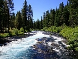
The Metolius River is a tributary of the Deschutes River (through Lake Billy Chinook
) in Central Oregon
, United States
, near the city of Sisters
. The river flows north from springs near Black Butte
, then turns sharply east, descending through a series of gorges before ending in the western end of the lake. The unincorporated community of Camp Sherman
lies astride the southern end of the river.
The river's drainage basin
is 315 square miles (815.8 km²) in area and, according to at least one estimate, contains 110 miles (177 km) of perennial streams, 324 miles (521.4 km) of intermittent streams, 42 lakes, and 121 ponds.
, where the river emerges from two clusters of springs, about 300 feet (91.4 m) apart. The springs are at the base of Black Butte. Water flows to these springs from the drainage basin around Black Butte Ranch
, several miles to the south. The elevation of the drainage basin is 300 feet (91.4 m) above that of the springs, forming a natural standpipe that tends to stabilize the river's rate of flow.
As a consequence, the water level in the Metolius River is relatively constant. The rate of flow at the headwaters is approximately 190 m³/min (6,700 ft³/min or 50,000 gallons per minute), although it grows by an additional 2,300 m³/min (80,000 ft³/min or 600,000 gallons per minute) by the time the river reaches Lake Billy Chinook. Similarly, the water temperature is also stable; at the river source, the water temperature is a consistent 48 °F (8.9 °C).
, emptying into Lake Billy Chinook and ultimately the Deschutes River. The upper 11.5 miles (18.5 km) of the river is a popular destination for catch-and-release fishing
, whitewater rafting, picnicking, and camping
. The lower 17 miles (27.4 km)is on the boundary of the Warm Springs Indian Reservation
, and is "a primitive area where motorized vehicles are not allowed."
The Metolius River was officially designated a National Wild and Scenic River
in 1988.
Many of the summer homes along the Metolius River are constructed on United States Forest Service
land, under provisions of a 1915 act of Congress
, and are generally required to be set back from the river at least 50 feet (15.2 m), allowing public access to the river.
, whitefish
, bull trout
and kokanee salmon. A number of small resorts and shops cater to fishermen and other visitors, principally in the community of Camp Sherman.
Hiking and horseback riding are popular activities in the area, particularly on the upper, southern portion of the river , with trails extending up and down the river and into the forests on both sides. There are also a number of developed campgrounds on the banks of the river. Fishing, rafting, hunting and cross-country skiing are all popular seasonal activities.
The Wizard Falls Fish Hatchery is also located approximately 10.6 miles (17.1 km) north of the headwaters. This hatchery raises rainbow trout, kokanee, and Atlantic salmon
. The hatchery is open to visitors, with various species of trout and other fish on display in ponds.
The Cove Palisades State Park
The Cove Palisades State Park is a state park in eastern Jefferson County, Oregon, near Culver and Madras in the central part of the state, and is administered by the Oregon Parks and Recreation Department...
) in Central Oregon
Central Oregon
Central Oregon is a geographic region in the U.S. state of Oregon and is traditionally considered to be made up of Deschutes, Jefferson, and Crook counties. Other definitions include larger areas, often encompassing areas to the north towards the Columbia River, eastward towards Burns, or south...
, United States
United States
The United States of America is a federal constitutional republic comprising fifty states and a federal district...
, near the city of Sisters
Sisters, Oregon
Sisters is a city in Deschutes County, Oregon, United States. It is part of the Bend, Oregon Metropolitan Statistical Area. The population was 959 at the 2000 census, but more than doubled to 2038 as of the 2010 census.- History :...
. The river flows north from springs near Black Butte
Black Butte (Oregon)
Black Butte is a cinder cone butte located in Deschutes National Forest, northwest of the town of Sisters, Oregon. An extinct volcano, it is composed of basaltic andesite. The cone rises over the surrounding plateau. Black Butte is a striking feature just north of US Highway 20, which descends...
, then turns sharply east, descending through a series of gorges before ending in the western end of the lake. The unincorporated community of Camp Sherman
Camp Sherman, Oregon
Camp Sherman is an unincorporated community in Jefferson County, Oregon, United States. It is located on the Metolius River. The population consists of a few hundred year-round residents, swelling to several thousand during the summer. The community includes an elementary school, Black Butte...
lies astride the southern end of the river.
The river's drainage basin
Drainage basin
A drainage basin is an extent or an area of land where surface water from rain and melting snow or ice converges to a single point, usually the exit of the basin, where the waters join another waterbody, such as a river, lake, reservoir, estuary, wetland, sea, or ocean...
is 315 square miles (815.8 km²) in area and, according to at least one estimate, contains 110 miles (177 km) of perennial streams, 324 miles (521.4 km) of intermittent streams, 42 lakes, and 121 ponds.
Headwaters
The headwaters of the river are at Metolius SpringsMetolius Springs
Metolius Springs are located just north of Black Butte near the small unincorporated town of Camp Sherman in central Oregon, United States. The springs are the source of the Metolius River, which flows through the Deschutes National Forest emptying into Lake Billy Chinook...
, where the river emerges from two clusters of springs, about 300 feet (91.4 m) apart. The springs are at the base of Black Butte. Water flows to these springs from the drainage basin around Black Butte Ranch
Black Butte Ranch, Oregon
Black Butte Ranch is a resort community in Deschutes County, Oregon, United States. It is located in the Cascade Range, eight miles northwest of Sisters. Black Butte Ranch is unicorporated and classed by the USGS as a populated place...
, several miles to the south. The elevation of the drainage basin is 300 feet (91.4 m) above that of the springs, forming a natural standpipe that tends to stabilize the river's rate of flow.
As a consequence, the water level in the Metolius River is relatively constant. The rate of flow at the headwaters is approximately 190 m³/min (6,700 ft³/min or 50,000 gallons per minute), although it grows by an additional 2,300 m³/min (80,000 ft³/min or 600,000 gallons per minute) by the time the river reaches Lake Billy Chinook. Similarly, the water temperature is also stable; at the river source, the water temperature is a consistent 48 °F (8.9 °C).
General
The Metolius River flows 28.6 miles (46 km) from Metolius Springs through the Deschutes National ForestDeschutes National Forest
The Deschutes National Forest is a United States National Forest located in parts of Deschutes, Klamath, Lake, and Jefferson counties in central Oregon. It comprises 1.8 million acres along the east side of the Cascade mountains. In 1908, the Deschutes National Forest was established from parts...
, emptying into Lake Billy Chinook and ultimately the Deschutes River. The upper 11.5 miles (18.5 km) of the river is a popular destination for catch-and-release fishing
Catch and release
Catch and release is a practice within recreational fishing intended as a technique of conservation. After capture, the fish are unhooked and returned to the water before experiencing serious exhaustion or injury...
, whitewater rafting, picnicking, and camping
Camping
Camping is an outdoor recreational activity. The participants leave urban areas, their home region, or civilization and enjoy nature while spending one or several nights outdoors, usually at a campsite. Camping may involve the use of a tent, caravan, motorhome, cabin, a primitive structure, or no...
. The lower 17 miles (27.4 km)is on the boundary of the Warm Springs Indian Reservation
Warm Springs Indian Reservation
The Warm Springs Indian Reservation consists of 1,019.385 sq mi in north central Oregon, in the United States, and is occupied and governed by the Confederated Tribes of Warm Springs.-Tribes:...
, and is "a primitive area where motorized vehicles are not allowed."
The Metolius River was officially designated a National Wild and Scenic River
National Wild and Scenic River
National Wild and Scenic River is a designation for certain protected areas in the United States.The National Wild and Scenic Rivers Act was an outgrowth of the recommendations of a Presidential commission, the Outdoor Recreation Resources Review Commission...
in 1988.
Many of the summer homes along the Metolius River are constructed on United States Forest Service
United States Forest Service
The United States Forest Service is an agency of the United States Department of Agriculture that administers the nation's 155 national forests and 20 national grasslands, which encompass...
land, under provisions of a 1915 act of Congress
United States Congress
The United States Congress is the bicameral legislature of the federal government of the United States, consisting of the Senate and the House of Representatives. The Congress meets in the United States Capitol in Washington, D.C....
, and are generally required to be set back from the river at least 50 feet (15.2 m), allowing public access to the river.
Recreation
Sport fishing on the Metolius River is catch-and-release, fly-fishing only (barbless hook), on the accessible, upper portion of the river, and includes rainbow troutRainbow trout
The rainbow trout is a species of salmonid native to tributaries of the Pacific Ocean in Asia and North America. The steelhead is a sea run rainbow trout usually returning to freshwater to spawn after 2 to 3 years at sea. In other words, rainbow trout and steelhead trout are the same species....
, whitefish
Freshwater whitefish
The freshwater whitefish are fish of the subfamily Coregoninae in the salmon family Salmonidae. Along with the freshwater whitefish, the Salmonidae includes the freshwater and anadromous trout and salmon species as well as graylings...
, bull trout
Bull trout
The bull trout, Salvelinus confluentus, is a char of the family Salmonidae native to northwestern North America. Historically, S. confluentus has been known as the "Dolly Varden" , but was re-classified as a separate species in 1980. Bull trout are listed as a threatened species under the U.S....
and kokanee salmon. A number of small resorts and shops cater to fishermen and other visitors, principally in the community of Camp Sherman.
Hiking and horseback riding are popular activities in the area, particularly on the upper, southern portion of the river , with trails extending up and down the river and into the forests on both sides. There are also a number of developed campgrounds on the banks of the river. Fishing, rafting, hunting and cross-country skiing are all popular seasonal activities.
The Wizard Falls Fish Hatchery is also located approximately 10.6 miles (17.1 km) north of the headwaters. This hatchery raises rainbow trout, kokanee, and Atlantic salmon
Atlantic salmon
The Atlantic salmon is a species of fish in the family Salmonidae, which is found in the northern Atlantic Ocean and in rivers that flow into the north Atlantic and the north Pacific....
. The hatchery is open to visitors, with various species of trout and other fish on display in ponds.
Coordinates
Coordinates from GNIS list one point per 7.5 minute map. The source and mouth are not repeated here.| seq num | location | usgs map |
|---|---|---|
| 2 | 44.5917842°N 121.3761607°W | Fly Creek |
| 3 | 44.6248387°N 121.4803320°W | Metolius Bench |
| 4 | 44.6353940°N 121.5011664°W | Shitike Butte |
| 5 | 44.6242834°N 121.6000583°W | Prairie Farm Spring |
| 6 | 44.5401168°N 121.6267231°W | Candle Creek |