
John Day Dam
Encyclopedia
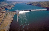
The John Day Dam is a concrete gravity run-of-the-river
dam
spanning the Columbia River
in the northwestern United States
. The dam features a navigation lock plus fish ladder
s on both sides. The John Day Lock has the highest lift (110 feet) of any U.S. lock. The reservoir impounded by the dam is Lake Umatilla
, and it runs 76.4 miles (123 kilometers) up the river channel to the foot of the McNary Dam
. John Day Dam is part of the Columbia River Basin
system of dams.
, and just below the mouth of the John Day River
. The closest town on the Washington side is Goldendale
, 20 miles (32 km) north. The closest town on the Oregon side is Rufus, Oregon
. Its crest elevation is approximately 570 feet (173.7 m) above sea level
. It joins Sherman County, Oregon
with Klickitat County, Washington, 216 miles (348 kilometers) upriver from the mouth of the Columbia near Astoria, Oregon
.
The dam underwent a major repair to the upper lock gate in 2010, as documented in the National Geographic Channel program "World's Toughest Fixes".
| publisher=United States Geological Survey
| accessdate=2006-05-10}} | title=John Day Dam (Washington - 269 ft. elev.) | work=Geographic Names Information System
| publisher=United States Geological Survey
| accessdate=2006-05-10}}
Run-of-the-river hydroelectricity
Run-of-the-river hydroelectricity is a type of hydroelectric generation whereby a considerably smaller water storage called pondage or none is used to supply a power station. Run-of-the-river power plants are classified as with or without pondage...
dam
Dam
A dam is a barrier that impounds water or underground streams. Dams generally serve the primary purpose of retaining water, while other structures such as floodgates or levees are used to manage or prevent water flow into specific land regions. Hydropower and pumped-storage hydroelectricity are...
spanning the Columbia River
Columbia River
The Columbia River is the largest river in the Pacific Northwest region of North America. The river rises in the Rocky Mountains of British Columbia, Canada, flows northwest and then south into the U.S. state of Washington, then turns west to form most of the border between Washington and the state...
in the northwestern United States
United States
The United States of America is a federal constitutional republic comprising fifty states and a federal district...
. The dam features a navigation lock plus fish ladder
Fish ladder
A fish ladder, also known as a fishway, fish pass or fish steps, is a structure on or around artificial barriers to facilitate diadromous fishes' natural migration. Most fishways enable fish to pass around the barriers by swimming and leaping up a series of relatively low steps into the waters on...
s on both sides. The John Day Lock has the highest lift (110 feet) of any U.S. lock. The reservoir impounded by the dam is Lake Umatilla
Lake Umatilla
Lake Umatilla is a long reservoir on the Columbia River in the United States, between the U.S. states of Washington and Oregon. It was created in 1971 with the construction of John Day Dam, and stretches upstream to the McNary Dam. It lies in parts of Sherman, Gilliam, Morrow, and Umatilla...
, and it runs 76.4 miles (123 kilometers) up the river channel to the foot of the McNary Dam
McNary Dam
McNary Dam is a 1.4-mile long concrete gravity run-of-the-river dam which spans the Columbia River. It joins Umatilla County, Oregon with Benton County, Washington, 292 miles upriver from the mouth of the Columbia at Astoria, Oregon. It is operated by the U.S. Army Corps of Engineers' McNary...
. John Day Dam is part of the Columbia River Basin
Columbia River
The Columbia River is the largest river in the Pacific Northwest region of North America. The river rises in the Rocky Mountains of British Columbia, Canada, flows northwest and then south into the U.S. state of Washington, then turns west to form most of the border between Washington and the state...
system of dams.
Location
John Day Dam is located 28 miles (45 km) east of the city of The Dalles, OregonThe Dalles, Oregon
The Dalles is the largest city and county seat of Wasco County, Oregon, United States. The name of the city comes from the French word dalle The Dalles is the largest city and county seat of Wasco County, Oregon, United States. The name of the city comes from the French word dalle The Dalles is...
, and just below the mouth of the John Day River
John Day River
The John Day River is a tributary of the Columbia River, approximately long, in northeastern Oregon in the United States. Undammed along its entire length, the river is the third longest free-flowing river in the conterminous United States. There is extensive use of its waters for irrigation. Its...
. The closest town on the Washington side is Goldendale
Goldendale, Washington
Goldendale is a rural agricultural town in and the county seat of Klickitat County, Washington, United States, near the Columbia River Gorge. The population within city limits was 3,760 at the 2000 census and 3,407, a 9.4% decrease at the 2010 census. A nationally known point of interest is north...
, 20 miles (32 km) north. The closest town on the Oregon side is Rufus, Oregon
Rufus, Oregon
Rufus is a city in Sherman County, Oregon, United States. The population was 268 at the 2000 census. The city was named for an early settler, Rufus Carrol Wallis.-Geography:...
. Its crest elevation is approximately 570 feet (173.7 m) above sea level
Sea level
Mean sea level is a measure of the average height of the ocean's surface ; used as a standard in reckoning land elevation...
. It joins Sherman County, Oregon
Sherman County, Oregon
Sherman County is a county located in the U.S. state of Oregon. The county is named for William Tecumseh Sherman, a Union general in the American Civil War. In 2010, its population was 1,765. The seat of the county is Moro. The largest city is Wasco....
with Klickitat County, Washington, 216 miles (348 kilometers) upriver from the mouth of the Columbia near Astoria, Oregon
Astoria, Oregon
Astoria is the county seat of Clatsop County, Oregon, United States. Situated near the mouth of the Columbia River, the city was named after the American investor John Jacob Astor. His American Fur Company founded Fort Astoria at the site in 1811...
.
History
Construction of the dam began in 1958 and was completed in 1971, making it the newest dam on the lower Columbia, at a total cost of US$511 million. John Day Dam was built and is operated by the U.S. Army Corps of Engineers. The dam's power generation capacity is 2,480,000 kW (overload capacity).The dam underwent a major repair to the upper lock gate in 2010, as documented in the National Geographic Channel program "World's Toughest Fixes".
Specifications
- Altitude: 266 feet (81 m) above sea level
- Height: 183 feet (56 m)
- Length: 7,365 feet (2,327 m)
- Navigation lock:
- Single-lift
- 86 feet (26 m) wide
- 675 feet (206 m) long
- Powerhouse
- Sixteen 135,000 kW units
- Total capacity: 2,160 MW
- Overload capacity: 2,485 MW
- Spillway
- Gates: 20
- Length: 1,228 feet (374 m)
See also
- Hydroelectric dams on the Columbia RiverHydroelectric dams on the Columbia RiverHydroelectric dams on the Columbia River and its tributaries in North America.- Mainstem Columbia dams :-Snake River:-Pend Oreille-Clark Fork–Flathead:-Kootenai River:-See also:...
- List of power stations in the United States
- List of hydroelectric power stations
Sources
| title=John Day Dam (Oregon - 164 ft. elev.) | work=Geographic Names Information SystemGeographic Names Information System
The Geographic Names Information System is a database that contains name and locative information about more than two million physical and cultural features located throughout the United States of America and its territories. It is a type of gazetteer...
| publisher=United States Geological Survey
United States Geological Survey
The United States Geological Survey is a scientific agency of the United States government. The scientists of the USGS study the landscape of the United States, its natural resources, and the natural hazards that threaten it. The organization has four major science disciplines, concerning biology,...
| accessdate=2006-05-10}} | title=John Day Dam (Washington - 269 ft. elev.) | work=Geographic Names Information System
Geographic Names Information System
The Geographic Names Information System is a database that contains name and locative information about more than two million physical and cultural features located throughout the United States of America and its territories. It is a type of gazetteer...
| publisher=United States Geological Survey
United States Geological Survey
The United States Geological Survey is a scientific agency of the United States government. The scientists of the USGS study the landscape of the United States, its natural resources, and the natural hazards that threaten it. The organization has four major science disciplines, concerning biology,...
| accessdate=2006-05-10}}
External links
- John Day Dam U.S. Army Corps of Engineers
- Google Maps