
Wallowa Lake
Encyclopedia
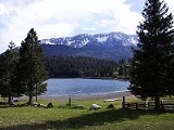
Wallowa Lake is a ribbon lake
one mile (1.6 km) south of Joseph, Oregon
, United States
. Impounded by high moraines, it was formed by a series of Pleistocene
glacier
s. On the south end of the lake is a small community made up of vacation homes, lodging, restaurants, as well as other small businesses. Wallowa Lake has been used for recreation since at least 1880. It lies at the lowest elevation of all the lakes in the Eagle Cap Wilderness
at 4372 ft (1,332.6 m). The Wallowa Lake State Park
is at the southern tip of the lake.
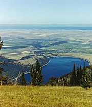
s. These moraines begin well below the water's surface and climb to over 900 ft (274.3 m) above the lake. Before the glacial till compounded enough to form the moraines that currently surround the lake, a large alluvial fan was present in the valley. This fan was created by the Wallowa River transporting debris into the valley. The sediment left by the river was pushed by a series of glaciers that advanced north into the valley. As they pushed the debris, they also dug deep into the earth. Though the number of glaciers that formed the moraines is debated, but the most accepted hypothesis is that eight or nine glaciers formed the walls that now dam the lake. The last glacier advanced into the valley about 17,000 years ago and is known as the Wallowa Glacier. Its moraines form much of the lake shore. Near Glacier Lake, high in the surrounding mountains, evidence of several subsequent glacier advances. Occurring subsequent to the formation of Wallowa Lake, these did not reach the location of the lake. The oldest of these was 11,000–10,000 years before present.
. The lake and its surrounding area was promised in a treaty to remain property of the Nez Perce. This lasted until gold was discovered in the area, which lead to a gold rush. In 1877 the U.S. Government took back the land and allowed it to be settled. This led to the formation of many of the nearby towns that still exist today.
The U.S. Government tried to force the Nez Perce to relocate to a reservation. However, this action made the tribe furious. They refused to live on a reservation and killed several of the white settlers out of protest. This caused a long battle between the U.S. Government and the Nez Perce, who were being led by Chief Joseph. The Nez Perce decided to flee to Canada, constantly fighting the U.S. forces along the way. After traveling 1,060 miles of the 1,100 mile long trail to Canada, the Nez Perce were trapped and forced to surrender. On October 5, 1877, the day of the surrender, Chief Joseph gave the following speech:
"I am tired of fighting. Our chiefs are killed. Looking Glass is dead. Toohulhulsote is dead. The old men are all dead. It is the young men who say yes or no. He who led the young men is dead. It is cold and we have no blankets. The little children are freezing to death. My people, some of them, have run away to the hills and have no blankets, no food. No one knows where they are, perhaps freezing to death. I want to have time to look for my children and see how many I can find. Maybe I shall find them among the dead. Hear me, my chiefs. I am tired. My heart is sick and sad. From where the sun now stands, I will fight no more, forever."
After the surrender, Chief Joseph and the Nez Perce were banished from the area. Today many monuments and dedications are set up at the lake and its surrounding cities in remembrance of the Nez Perce tribe and the battle that took place. In 1880 The town nearest to Wallowa Lake, Joseph
, was named after Chief Joseph. The battle is remembered by historians as one of the last battles the U.S. forces had with Native Americans. It is also remembered and used as an example of the injustice the Native American people faced by the U.S. Government.
. In 1879 a man named Matthew Johnson who was the first post master for Joseph
, ran the first store. Due to the needs of the crowds of gold miners who were flocking to the area, the store was a success and the town of Joseph
began to grow. The area became so populated that Wallowa County
was formed in 1887, which encompassed the lake and its surrounding cities.
 Wallowa Lake gained popularity among gold miners and soon began attracting guests from other areas. Seeing an emerging tourism market, entrepreneurs began building businesses at the lake. Among those built was the Wonderland Inn, now known as the Wallowa Lake Lodge. The Wonderland Inn was developed in 1923 as an amusement park at the south end of the lake. The park contained a restaurant, store, bowling alley, dance hall, outdoor movie theater, horse drawn carousel and cabins for those wishing to stay overnight. An 18 passenger boat carried the guests who arrived in Joseph (which lies at the north end of the lake) down the entire four mile stretch of Wallowa Lake, finally arriving that the inn and amusement park.
The amusement park operated until 1940 when snow fall from an unusually harsh winter crushed most of the buildings and rendered the park inoperable. However, the inn survived the winter and still remains in operation, though renamed the Wallowa Lake Lodge. The area at the south end of the lake continued to be developed commercially. Several more stores, lodges, restaurants, and rental cabins where built in the following years, turning the south end of the lake into a tourist community.
Currently, the collection of businesses at the south end of Wallowa Lake are members of a non-profit tourism association. This association maintains a website, supports tourism in the area and works to solve issues across the lake community. For more information about the Wallowa Lake Tourism Association see the web site www.wallowalake.net. This web site also provides information about available activities at the south end of Wallowa Lake.
There are 2000 to 3000 people residing at the south end of Wallowa Lake in summer with all businesses open. However, from October through March there are less-than 40 year-around residences at the south end of the lake with only a few lodging businesses open.
. It runs from the bottom of the valley to the top of Mount Howard, which is measured at 8000 ft (2,438.4 m). It was built in 1968 and opened to the public in 1970. From the tram car, the passenger can see spectacular views of Wallowa Lake as well as the surrounding mountains. In June 1992, a malfunction occurred in the operating system of the Tram and all passengers had to be evacuated by helicopter. There were no injuries and the incident serves as the only such problem that has occurred on the Tramway.
Ribbon lake
A ribbon lake or loch is a long and narrow, finger-shaped lake, usually found in a glacial trough. Its formation begins when a glacier moves over an area containing alternate bands of hard and soft bedrock...
one mile (1.6 km) south of Joseph, Oregon
Joseph, Oregon
Joseph is a city in Wallowa County, Oregon, United States. Originally named Silver Lake and Lake City, in 1880 the city formally named itself for Nez Perce Chief Joseph. The population was 1,054 at the 2000 census.- History :...
, United States
United States
The United States of America is a federal constitutional republic comprising fifty states and a federal district...
. Impounded by high moraines, it was formed by a series of Pleistocene
Pleistocene
The Pleistocene is the epoch from 2,588,000 to 11,700 years BP that spans the world's recent period of repeated glaciations. The name pleistocene is derived from the Greek and ....
glacier
Glacier
A glacier is a large persistent body of ice that forms where the accumulation of snow exceeds its ablation over many years, often centuries. At least 0.1 km² in area and 50 m thick, but often much larger, a glacier slowly deforms and flows due to stresses induced by its weight...
s. On the south end of the lake is a small community made up of vacation homes, lodging, restaurants, as well as other small businesses. Wallowa Lake has been used for recreation since at least 1880. It lies at the lowest elevation of all the lakes in the Eagle Cap Wilderness
Eagle Cap Wilderness
Eagle Cap Wilderness is a wilderness area located in the Wallowa Mountains of northeastern Oregon , within the Wallowa–Whitman National Forest. The Wilderness was established in 1940. In 1964, it was included in the National Wilderness Preservation System...
at 4372 ft (1,332.6 m). The Wallowa Lake State Park
Wallowa Lake State Park
Wallowa Lake State Park is a state park located in northeast Oregon in the United States. It is at the southern shore of Wallowa Lake, near the city of Joseph in Wallowa County....
is at the southern tip of the lake.
Geology and formation
Wallowa Lake has been used in Geology text books as an example of a lake dammed by moraineMoraine
A moraine is any glacially formed accumulation of unconsolidated glacial debris which can occur in currently glaciated and formerly glaciated regions, such as those areas acted upon by a past glacial maximum. This debris may have been plucked off a valley floor as a glacier advanced or it may have...
s. These moraines begin well below the water's surface and climb to over 900 ft (274.3 m) above the lake. Before the glacial till compounded enough to form the moraines that currently surround the lake, a large alluvial fan was present in the valley. This fan was created by the Wallowa River transporting debris into the valley. The sediment left by the river was pushed by a series of glaciers that advanced north into the valley. As they pushed the debris, they also dug deep into the earth. Though the number of glaciers that formed the moraines is debated, but the most accepted hypothesis is that eight or nine glaciers formed the walls that now dam the lake. The last glacier advanced into the valley about 17,000 years ago and is known as the Wallowa Glacier. Its moraines form much of the lake shore. Near Glacier Lake, high in the surrounding mountains, evidence of several subsequent glacier advances. Occurring subsequent to the formation of Wallowa Lake, these did not reach the location of the lake. The oldest of these was 11,000–10,000 years before present.
The gold rush and battle with the Nez Perce
The Wallowa Lake area was inhabited by the Nez Perce tribe prior to the exploration of the area and the formation of the U.S. State of OregonOregon
Oregon is a state in the Pacific Northwest region of the United States. It is located on the Pacific coast, with Washington to the north, California to the south, Nevada on the southeast and Idaho to the east. The Columbia and Snake rivers delineate much of Oregon's northern and eastern...
. The lake and its surrounding area was promised in a treaty to remain property of the Nez Perce. This lasted until gold was discovered in the area, which lead to a gold rush. In 1877 the U.S. Government took back the land and allowed it to be settled. This led to the formation of many of the nearby towns that still exist today.
The U.S. Government tried to force the Nez Perce to relocate to a reservation. However, this action made the tribe furious. They refused to live on a reservation and killed several of the white settlers out of protest. This caused a long battle between the U.S. Government and the Nez Perce, who were being led by Chief Joseph. The Nez Perce decided to flee to Canada, constantly fighting the U.S. forces along the way. After traveling 1,060 miles of the 1,100 mile long trail to Canada, the Nez Perce were trapped and forced to surrender. On October 5, 1877, the day of the surrender, Chief Joseph gave the following speech:
"I am tired of fighting. Our chiefs are killed. Looking Glass is dead. Toohulhulsote is dead. The old men are all dead. It is the young men who say yes or no. He who led the young men is dead. It is cold and we have no blankets. The little children are freezing to death. My people, some of them, have run away to the hills and have no blankets, no food. No one knows where they are, perhaps freezing to death. I want to have time to look for my children and see how many I can find. Maybe I shall find them among the dead. Hear me, my chiefs. I am tired. My heart is sick and sad. From where the sun now stands, I will fight no more, forever."
After the surrender, Chief Joseph and the Nez Perce were banished from the area. Today many monuments and dedications are set up at the lake and its surrounding cities in remembrance of the Nez Perce tribe and the battle that took place. In 1880 The town nearest to Wallowa Lake, Joseph
Joseph, Oregon
Joseph is a city in Wallowa County, Oregon, United States. Originally named Silver Lake and Lake City, in 1880 the city formally named itself for Nez Perce Chief Joseph. The population was 1,054 at the 2000 census.- History :...
, was named after Chief Joseph. The battle is remembered by historians as one of the last battles the U.S. forces had with Native Americans. It is also remembered and used as an example of the injustice the Native American people faced by the U.S. Government.
Formation of Joseph and Wallowa Lake tourism
The first businesses near the lake were in the town of JosephJoseph, Oregon
Joseph is a city in Wallowa County, Oregon, United States. Originally named Silver Lake and Lake City, in 1880 the city formally named itself for Nez Perce Chief Joseph. The population was 1,054 at the 2000 census.- History :...
. In 1879 a man named Matthew Johnson who was the first post master for Joseph
Joseph, Oregon
Joseph is a city in Wallowa County, Oregon, United States. Originally named Silver Lake and Lake City, in 1880 the city formally named itself for Nez Perce Chief Joseph. The population was 1,054 at the 2000 census.- History :...
, ran the first store. Due to the needs of the crowds of gold miners who were flocking to the area, the store was a success and the town of Joseph
Joseph, Oregon
Joseph is a city in Wallowa County, Oregon, United States. Originally named Silver Lake and Lake City, in 1880 the city formally named itself for Nez Perce Chief Joseph. The population was 1,054 at the 2000 census.- History :...
began to grow. The area became so populated that Wallowa County
Wallowa County, Oregon
Wallowa County is a county located in the U.S. state of Oregon. It is included in the 8 county definition of Eastern Oregon. According to Oregon Geographic Names, the origins of the county's name are uncertain, with the most likely explanation being that it is derived from the Nez Perce term for a...
was formed in 1887, which encompassed the lake and its surrounding cities.
The amusement park operated until 1940 when snow fall from an unusually harsh winter crushed most of the buildings and rendered the park inoperable. However, the inn survived the winter and still remains in operation, though renamed the Wallowa Lake Lodge. The area at the south end of the lake continued to be developed commercially. Several more stores, lodges, restaurants, and rental cabins where built in the following years, turning the south end of the lake into a tourist community.
Currently, the collection of businesses at the south end of Wallowa Lake are members of a non-profit tourism association. This association maintains a website, supports tourism in the area and works to solve issues across the lake community. For more information about the Wallowa Lake Tourism Association see the web site www.wallowalake.net. This web site also provides information about available activities at the south end of Wallowa Lake.
There are 2000 to 3000 people residing at the south end of Wallowa Lake in summer with all businesses open. However, from October through March there are less-than 40 year-around residences at the south end of the lake with only a few lodging businesses open.
Wallowa Lake Tramway
Located near the lake is an aerial cable gondola liftGondola lift
A gondola lift is a type of aerial lift, normally called a cable car, which is supported and propelled by cables from above. It consists of a loop of steel cable that is strung between two stations, sometimes over intermediate supporting towers. The cable is driven by a bullwheel in a terminal,...
. It runs from the bottom of the valley to the top of Mount Howard, which is measured at 8000 ft (2,438.4 m). It was built in 1968 and opened to the public in 1970. From the tram car, the passenger can see spectacular views of Wallowa Lake as well as the surrounding mountains. In June 1992, a malfunction occurred in the operating system of the Tram and all passengers had to be evacuated by helicopter. There were no injuries and the incident serves as the only such problem that has occurred on the Tramway.