
Fairview Creek
Encyclopedia
Fairview Creek is a 5 miles (8 km) tributary of the Columbia Slough
in the U.S. state
of Oregon
. The creek forms in a wetland
near Grant Butte in Gresham
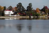
and flows north for 5 miles (8 km) to Fairview Lake in Fairview
. Grant Butte, rising to 602 feet (183.5 m) above sea level
, is one of eight dormant volcanic
formations near Gresham. Fairview Creek begins northeast of the butte at an elevation of 278 feet (84.7 m) and falls to an elevation of 10 feet (3 m) at the lake.
The creek is a former tributary of the Columbia River
, which it reached by flowing north through wetlands in the Columbia's floodplain
. In the early 20th century, an artificial channel diverted the water from these wetlands to the Columbia Slough, a tributary of the Willamette River
. In 1960, water managers built a dam to create Fairview Lake for water storage and recreation. The lake covers about 100 acres (40.5 ha) and is 5 feet (1.5 m) to 6 feet (1.8 m) deep. Fairview Creek has two named tributaries, No Name Creek, and Clear Creek. A smaller stream, Osborn Creek, also flows into Fairview Lake, which empties through a weir
and culvert
system on the west side of the lake into the upper slough.
In 2002, the City of Gresham adopted a plan for a 5.2 miles (8.4 km) hiking and biking trail to run partly along the creek. The trail was designed to provide a north-south connection between the Springwater Corridor
Trail along Johnson Creek
to the south and the 40 Mile Loop
trail along the Columbia River. As of 2008, a 1.24 miles (2 km) segment of the trail between Northeast Halsey Street and Northeast Burnside Road was open to the public. Unfinished segments between Northeast Halsey and the Springwater Corridor are expected to be ready by autumn 2009. If so, at that point 3.49 miles (5.6 km) of the trail will be open to the public.
Columbia Slough
The Columbia Slough is a narrow waterway, about long, in the floodplain of the Columbia River in the U.S. state of Oregon. From its source in the Portland suburb of Fairview, the Columbia Slough meanders west through Gresham and Portland to the Willamette River, about from the Willamette's...
in the U.S. state
U.S. state
A U.S. state is any one of the 50 federated states of the United States of America that share sovereignty with the federal government. Because of this shared sovereignty, an American is a citizen both of the federal entity and of his or her state of domicile. Four states use the official title of...
of Oregon
Oregon
Oregon is a state in the Pacific Northwest region of the United States. It is located on the Pacific coast, with Washington to the north, California to the south, Nevada on the southeast and Idaho to the east. The Columbia and Snake rivers delineate much of Oregon's northern and eastern...
. The creek forms in a wetland
Wetland
A wetland is an area of land whose soil is saturated with water either permanently or seasonally. Wetlands are categorised by their characteristic vegetation, which is adapted to these unique soil conditions....
near Grant Butte in Gresham
Gresham, Oregon
- Demographics :As of the census of 2000, there were 90,205 people, 33,327 households, and 22,695 families residing in the city. The population density was 4,071.6 people per square mile . There were 35,309 housing units at an average density of 1,593.8 per square mile...
and flows north for 5 miles (8 km) to Fairview Lake in Fairview
Fairview, Oregon
As of the census of 2000, there were 7,561 people, 2,831 households, and 1,936 families residing in the city. The population density was 2,360.8 people per square mile . There were 3,116 housing units at an average density of 972.9 per square mile...
. Grant Butte, rising to 602 feet (183.5 m) above sea level
Sea level
Mean sea level is a measure of the average height of the ocean's surface ; used as a standard in reckoning land elevation...
, is one of eight dormant volcanic
Volcano
2. Bedrock3. Conduit 4. Base5. Sill6. Dike7. Layers of ash emitted by the volcano8. Flank| 9. Layers of lava emitted by the volcano10. Throat11. Parasitic cone12. Lava flow13. Vent14. Crater15...
formations near Gresham. Fairview Creek begins northeast of the butte at an elevation of 278 feet (84.7 m) and falls to an elevation of 10 feet (3 m) at the lake.
The creek is a former tributary of the Columbia River
Columbia River
The Columbia River is the largest river in the Pacific Northwest region of North America. The river rises in the Rocky Mountains of British Columbia, Canada, flows northwest and then south into the U.S. state of Washington, then turns west to form most of the border between Washington and the state...
, which it reached by flowing north through wetlands in the Columbia's floodplain
Floodplain
A floodplain, or flood plain, is a flat or nearly flat land adjacent a stream or river that stretches from the banks of its channel to the base of the enclosing valley walls and experiences flooding during periods of high discharge...
. In the early 20th century, an artificial channel diverted the water from these wetlands to the Columbia Slough, a tributary of the Willamette River
Willamette River
The Willamette River is a major tributary of the Columbia River, accounting for 12 to 15 percent of the Columbia's flow. The Willamette's main stem is long, lying entirely in northwestern Oregon in the United States...
. In 1960, water managers built a dam to create Fairview Lake for water storage and recreation. The lake covers about 100 acres (40.5 ha) and is 5 feet (1.5 m) to 6 feet (1.8 m) deep. Fairview Creek has two named tributaries, No Name Creek, and Clear Creek. A smaller stream, Osborn Creek, also flows into Fairview Lake, which empties through a weir
Weir
A weir is a small overflow dam used to alter the flow characteristics of a river or stream. In most cases weirs take the form of a barrier across the river that causes water to pool behind the structure , but allows water to flow over the top...
and culvert
Culvert
A culvert is a device used to channel water. It may be used to allow water to pass underneath a road, railway, or embankment. Culverts can be made of many different materials; steel, polyvinyl chloride and concrete are the most common...
system on the west side of the lake into the upper slough.
In 2002, the City of Gresham adopted a plan for a 5.2 miles (8.4 km) hiking and biking trail to run partly along the creek. The trail was designed to provide a north-south connection between the Springwater Corridor
Springwater Corridor
The Springwater Corridor Trail is a bicycle and pedestrian rail trail in the Portland metropolitan area in Oregon, United States. It follows a former railway line of the same name in its route from Boring, through Gresham, to Portland, where it ends near the Eastbank Esplanade. A large segment...
Trail along Johnson Creek
Johnson Creek (Willamette River)
Johnson Creek is a 25-mile tributary of the Willamette River in the Portland metropolitan area of the U.S. state of Oregon. Part of the drainage basin of the Columbia River, its watershed consists of of mostly urban land occupied by about 175,000 people as of 2006...
to the south and the 40 Mile Loop
40 Mile Loop
The 40-Mile Loop is a partially completed greenway trail around and through Portland in the U.S. State of Oregon. It was proposed in 1903 by the Olmsted Brothers architecture firm as part of the development of Forest Park....
trail along the Columbia River. As of 2008, a 1.24 miles (2 km) segment of the trail between Northeast Halsey Street and Northeast Burnside Road was open to the public. Unfinished segments between Northeast Halsey and the Springwater Corridor are expected to be ready by autumn 2009. If so, at that point 3.49 miles (5.6 km) of the trail will be open to the public.