

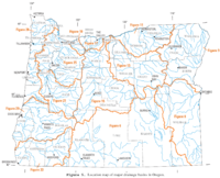
List of Oregon rivers
Encyclopedia
United States
The United States of America is a federal constitutional republic comprising fifty states and a federal district...
. The list of Oregon
Oregon
Oregon is a state in the Pacific Northwest region of the United States. It is located on the Pacific coast, with Washington to the north, California to the south, Nevada on the southeast and Idaho to the east. The Columbia and Snake rivers delineate much of Oregon's northern and eastern...
river
River
A river is a natural watercourse, usually freshwater, flowing towards an ocean, a lake, a sea, or another river. In a few cases, a river simply flows into the ground or dries up completely before reaching another body of water. Small rivers may also be called by several other names, including...
s is organized alphabetically and by tributary
Tributary
A tributary or affluent is a stream or river that flows into a main stem river or a lake. A tributary does not flow directly into a sea or ocean...
structure. The list may also include stream
Stream
A stream is a body of water with a current, confined within a bed and stream banks. Depending on its locale or certain characteristics, a stream may be referred to as a branch, brook, beck, burn, creek, "crick", gill , kill, lick, rill, river, syke, bayou, rivulet, streamage, wash, run or...
s known as creeks, brooks, forks, branches and prongs, as well as slough
River delta
A delta is a landform that is formed at the mouth of a river where that river flows into an ocean, sea, estuary, lake, reservoir, flat arid area, or another river. Deltas are formed from the deposition of the sediment carried by the river as the flow leaves the mouth of the river...
s and channels.
A list of rivers of the Americas and a list of Pacific Ocean coast rivers of the Americas are also available, as is a list of Oregon lakes.
Alphabetical listing
- Abiqua CreekAbiqua CreekAbiqua Creek is a tributary of the Pudding River in the U.S. state of Oregon. The creek originates near Lookout Mountain in the foothills of the Cascade Range in the northwestern part of the state. It flows northwest for about to its confluence with the Pudding, about west of Silverton, in the...
- Agency Creek (South Yamhill River)Agency Creek (South Yamhill River)Agency Creek is a stream in the U.S. state of Oregon, located in Yamhill County. Agency Creek is a tributary to the South Yamhill River....
- Alsea RiverAlsea RiverThe Alsea River flows from Alsea, an unincorporated community in the coastal mountains of the U.S. state of Oregon, to the Pacific Ocean near the city of Waldport. It begins at the confluence of the North Fork Alsea River and the South Fork Alsea River and ends in Alsea Bay, a wide estuary at...
- Amazon CreekAmazon CreekAmazon Creek is a stream that runs through parts of Eugene, Oregon, United States. It is a tributary of the Long Tom River and is Eugene's second-largest waterway after the Willamette River.-Background:...
- Ana RiverAna RiverThe Ana River is a short spring-fed river in south-central Oregon. It is on the northwestern edge of the Great Basin drainage. It flows from springs at the foot of Winter Ridge through high desert, range, and wetlands before emptying into Summer Lake...
- Applegate RiverApplegate RiverThe Applegate River is a long tributary of the Rogue River in the U.S. state of Oregon. It drains approximately . Rising in northern California, it soon crosses the border and flows northeast then northwest to meet the Rogue about west of Grants Pass...
- Ash CreekAsh Creek (Polk County, Oregon)Ash Creek is a stream in Polk County, Oregon, United States. It originates in the Oregon Coast Range and feeds into the Willamette River at Independence.-External links:*...
- Balch CreekBalch CreekBalch Creek is a tributary of the Willamette River in the U.S. state of Oregon. Beginning at the crest of the Tualatin Mountains , the creek flows generally east down a canyon along Northwest Cornell Road in unincorporated Multnomah County and through the Macleay Park section of Forest Park, a...
- Bear CreekBear Creek (Oregon)Bear Creek is the name of a stream located entirely within Jackson County, Oregon. The stream drains approximately of the Rogue Valley and discharges an annual average of 114 cubic feet per second into the Rogue River...
- Big Butte CreekBig Butte CreekBig Butte Creek is a long tributary of the Rogue River located in the U.S. state of Oregon. It drains approximately of Jackson County. The north fork of the creek begins on Rustler Peak and the south fork's headwaters are near Mount McLoughlin...
- Big Marsh CreekBig Marsh CreekBig Marsh Creek is a stream in Klamath County, Oregon, United States. It flows to its mouth at Crescent Creek. Both rivers are part of the National Wild and Scenic Rivers System....
- Big RiverBig River (Oregon)The Big River is a tributary of the Coast Fork Willamette River, approximately 12 mi long, in western Oregon in the United States. It drains an area of the Calapooya Mountains south of Eugene....
- Birch Creek
- Blue RiverBlue River (Oregon)Blue River is a river in Lane County of the U.S. state of Oregon. It joins the McKenzie River near the community of Blue River, Oregon. The river was named for the striking blue color that apparently comes from its rocky bed....
- Breitenbush RiverBreitenbush RiverThe Breitenbush River is a tributary of the North Santiam River in western Oregon in the United States. It drains a rugged, forested area of the Cascade Range east of Salem....
- Bridge Creek (John Day River)
- Bull Run RiverBull Run River (Oregon)The Bull Run River is a tributary of the Sandy River in the U.S. state of Oregon. Beginning at the lower end of Bull Run Lake in the Cascade Range, it flows generally west through the Bull Run Watershed Management Unit , a restricted area meant to protect the river and its tributaries from...
- Burnt RiverBurnt River (Oregon)The Burnt River is a tributary of the Snake River in eastern Oregon, United States. It enters the Snake near Huntington, Oregon, at a point upstream of the Powder River and downstream of the Malheur River, slightly more than from the Snake's confluence with the Columbia River...
- Butte CreekButte Creek (Oregon)Butte Creek is a stream in the U.S. state of Oregon, a tributary of the Pudding River. It is approximately long and, for all of its course, defines part of the northeastern boundary of Marion County and the southern boundary of Clackamas County.- Course :...
- Calapooia RiverCalapooia RiverThe Calapooia River is a tributary of the Willamette River in the U.S. state of Oregon.The Calapooia runs through Crawfordsville and Brownsville in the Willamette Valley. The river converges with the Willamette near Albany. It was named for the Kalapuya , a tribe of Native Americans.-References:...
- Catherine Creek
- Chetco RiverChetco RiverThe Chetco River is a stream located in the southwestern portion of the U.S. state of Oregon. It drains approximately of Curry County. Flowing through a rugged and isolated coastal region, it descends rapidly from about to sea level at the Pacific Ocean. Except for the lowermost , the river is...
- Chewaucan RiverChewaucan RiverThe Chewaucan River is part of the Great Basin drainage. It flows through the Fremont–Winema National Forests, Bureau of Land Management land, and private property in southern Oregon. Its watershed consists of of conifer forest, marsh, and rural pasture land...
- Clackamas RiverClackamas RiverThe Clackamas River is an approximately tributary of the Willamette River in northwestern Oregon, in the United States. As it drains an area of about , the Clackamas passes through mostly forested and rugged mountainous terrain in its upper reaches, and passes through agricultural and urban areas...
- Clatskanie RiverClatskanie RiverThe Clatskanie River is a tributary of the Columbia River, approximately long, in northwestern Oregon in the United States. It drains a timber-producing area in the foothills of the Northern Oregon Coast Range north-northwest of Portland....
- Clear ForkClear Fork (Oregon)Clear Fork is a stream in the U.S. state of Oregon, located in Clackamas County....
- Clearwater RiverClearwater River (Oregon)The Clearwater River is a river in Douglas County of the U.S. state of Oregon. It is a roughly long tributary of the North Umpqua River, located about east of Roseburg in the Cascade Range....
- Coast Fork Willamette RiverCoast Fork Willamette RiverThe Coast Fork Willamette River is one of several forks that unite to form the Willamette River in western Oregon in the United States. It is about long, draining an area of the mountains at the south end of the Willamette Valley south of Eugene.-Course:...
- Collawash RiverCollawash RiverThe Collawash River is a tributary of the Clackamas River in the U.S. state of Oregon. Formed by the confluence of Elk Lake Creek and the East Fork Collawash River in the Cascade Range, it flows generally north-northwest from source to mouth through the Mount Hood National Forest. The largest...
- Columbia RiverColumbia RiverThe Columbia River is the largest river in the Pacific Northwest region of North America. The river rises in the Rocky Mountains of British Columbia, Canada, flows northwest and then south into the U.S. state of Washington, then turns west to form most of the border between Washington and the state...
- Columbia SloughColumbia SloughThe Columbia Slough is a narrow waterway, about long, in the floodplain of the Columbia River in the U.S. state of Oregon. From its source in the Portland suburb of Fairview, the Columbia Slough meanders west through Gresham and Portland to the Willamette River, about from the Willamette's...
- Coos RiverCoos RiverThe Coos River flows for about into Coos Bay along the Pacific coast of southwest Oregon in the United States. Formed by the confluence of its major tributaries, the South Fork Coos River and the Millicoma River, it drains an important timber-producing region of the Southern Oregon Coast Range...
- Coquille RiverCoquille RiverThe Coquille River is a stream long, in southwestern Oregon in the United States. It drains a mountainous area of of the Southern Oregon Coast Range into the Pacific Ocean. Its watershed is located between that of the Coos River to the north and the Rogue River to the south.-Geography:The river,...
- Crabtree Creek
- Crescent Creek
- Crooked RiverCrooked River (Oregon)The Crooked River is a tributary, long, of the Deschutes River in the U.S. state of Oregon. The river begins at the confluence of South Fork Crooked River and Beaver Creek. Of the two tributaries, the South Fork Crooked River is the larger and is sometimes considered part of the Crooked River proper...
- Cultus RiverCultus RiverThe Cultus River is a stream in the U.S. state of Oregon, located in Deschutes County....
- D RiverD RiverThe D River is a river in Lincoln City, Oregon, United States. Proclaimed the "shortest river in the world" by the State of Oregon, it was listed in the Guinness World Records as the world's shortest river at . This title was lost in 1989 when Guinness named the Roe River in Montana as the world's...
- Dead River
- Deschutes River
- Dog RiverDog River (Oregon)The Dog River is a small river in Oregon's Cascade Range and drains a few eastern foothills of Mount Hood. It is a tributary of East Fork Hood River and also contributes water for The Dalles and Hood River water systems....
- Donner und Blitzen RiverDonner und Blitzen RiverThe Donner und Blitzen River is a river on the eastern Oregon high desert which drains a relatively arid basin, the southern portion of Harney Basin, from roughly 20 to 80 miles south-southeast of Burns including Malheur National Wildlife Refuge...
- Dry River
- Dry Well CreekDry Well CreekDry Well Creek is a creek in Harney County, Oregon, United States in the Harney Basin of Eastern Oregon. It is located at an elevation of 5000 feet, and is one of a series of streams that eventually drains into Malheur Lake, a Great Basin lake that has no outlet...
- East Fork Hood River
- East Fork Quinn River
- East Fork Salmon River
- East Fork Silvies RiverSilvies RiverThe Silvies River flows for about through Grant and Harney counties in the U.S. state of Oregon. The river drains of the northern Harney Basin....
- East Fork South Fork McKenzie River
- Elk RiverElk River (Oregon)The Elk River is in southwestern Oregon in the United States. Approximately 25 miles long, the river drains a remote area of the Coastal Range into the Pacific Ocean....
- Elkhorn Creek
- Fall River
- Fanno CreekFanno CreekFanno Creek is a tributary of the Tualatin River in the U.S. state of Oregon. Part of the drainage basin of the Columbia River, its watershed covers about in Multnomah, Washington, and Clackamas counties, including about within the Portland city limits....
- Five RiversFive Rivers (Oregon)Five Rivers is a stream in the U.S. state of Oregon, located in Benton County....
- Gales CreekGales Creek (Oregon)Gales Creek, is a tributary, long, of the Tualatin River in Washington County, Oregon, United States. The headwaters of Gales Creek are on the north side of the mountain Round Top in the Northern Oregon Coast Range...
- Gilbert RiverGilbert River (Oregon)The Gilbert River is a river on Sauvie Island in the U.S. state of Oregon which flows from Sturgeon Lake into the Multnomah Channel of the Willamette River....
- Grande Ronde RiverGrande Ronde RiverThe Grande Ronde River is a tributary of the Snake River, long, in northeastern Oregon and southeastern Washington in the United States. It drains an area southeast of the Blue Mountains and northwest of the Wallowa Mountains, on the Columbia Plateau...
- Green River
- Hood River
- Illinois RiverIllinois River (Oregon)The Illinois River is a tributary, about long, of the Rogue River in the U.S. state of Oregon. It drains part of the Klamath Mountains in northern California and southwestern Oregon. The river's main stem begins at the confluence of its east and west forks near Cave Junction in southern Josephine...
- Imnaha RiverImnaha RiverThe Imnaha River is a tributary of the Snake River in the U.S. state of Oregon. Flowing generally east near the headwaters and then north through Wallowa County, the entire river is designated Wild and Scenic...
- John Day RiverJohn Day RiverThe John Day River is a tributary of the Columbia River, approximately long, in northeastern Oregon in the United States. Undammed along its entire length, the river is the third longest free-flowing river in the conterminous United States. There is extensive use of its waters for irrigation. Its...
(north central Oregon) - John Day RiverJohn Day River (northwestern Oregon)The John Day River is a tributary of the Columbia River, approximately long, in northwestern Oregon in the United States. The river is one of two tributaries of the Columbia in Oregon to bear the name "John Day River". The other John Day River, east of the Cascade Range, is much longer and more...
(Clatsop CountyClatsop County, OregonClatsop County is a county located in the U.S. state of Oregon. The county is named for the Clatsop tribe of Native Americans, who lived along the coast of the Pacific Ocean prior to European settlement. As of 2010, the population was 37,039. The county seat is Astoria.-Economy:The principal...
) - Johnson CreekJohnson Creek (Willamette River)Johnson Creek is a 25-mile tributary of the Willamette River in the Portland metropolitan area of the U.S. state of Oregon. Part of the drainage basin of the Columbia River, its watershed consists of of mostly urban land occupied by about 175,000 people as of 2006...
- Joseph Creek
- Kiger Creek
- Kings RiverKings River (Nevada)The Kings River is a tributary of the Quinn River, about long, in northwestern Nevada and south-central Oregon in the United States. It drains a remote arid area of the northwestern Great Basin....
- Kilchis RiverKilchis RiverThe Kilchis River is a stream, about long, near the coast of northwest Oregon in the United States. It drains a mountainous timbered region of about in the Northern Oregon Coast Range west of Portland....
- Klamath RiverKlamath RiverThe Klamath River is an American river that flows southwest through Oregon and northern California, cutting through the Cascade Range to empty into the Pacific Ocean. The river drains an extensive watershed of almost that stretches from the high desert country of the Great Basin to the temperate...
- Klaskanine RiverKlaskanine RiverThe Klaskanine River is a tributary of the Youngs River, approximately long, in northwest Oregon in the United States. It drains a small section of the Coast Range in the extreme northwest corner of the state in the watershed of the nearby Columbia River....
- Lake Fork West Owyhee River
- Lewis and Clark RiverLewis and Clark RiverThe Lewis and Clark River is a tributary of the Columbia River, approximately long, in northwest Oregon in the United States. It drains of the Northern Oregon Coast Range in the extreme northwest corner of the state, entering the Columbia near its mouth. Near the river's mouth is the site of...
- Link RiverLink RiverThe Link River is a short river connecting Upper Klamath Lake to Lake Ewauna in the city of Klamath Falls in the U.S. state of Oregon. Draining a basin of , the river begins at the southern end of Klamath Lake and flows a short distance to the Link River Dam and continues to the head of Lake Ewauna...
- Little Applegate RiverLittle Applegate RiverThe Little Applegate River is a long tributary of the Applegate River located in the U.S. state of Oregon. It is part of the Rogue River watershed, draining approximately of Jackson County...
- Little Blitzen RiverLittle Blitzen RiverLittle Blitzen River is a tributary of the Donner und Blitzen River in the U.S. state of Oregon. Little Blitzen River rises on the west flank of Steens Mountain about southeast of Frenchglen and about south of Burns in Harney County...
- Little Butte CreekLittle Butte Creek (Rogue River)Little Butte Creek is a long tributary of the Rogue River located in the U.S. state of Oregon. Its drainage basin consists of approximately of Jackson County, and another in Klamath County. The north fork of the creek begins at Fish Lake, while the south fork begins near Brown Mountain. The two...
- Little Chetco River
- Little Clatskanie River
- Little Deschutes River
- Little Luckiamute RiverLittle Luckiamute RiverThe Little Luckiamute River is a stream in Polk County in the U.S. state of Oregon. It rises in the Central Oregon Coast Range near Fanno Peak and joins the Luckiamute River about upstream of the Sarah Helmick State Recreation Site southwest of Monmouth....
- Little Malheur River
- Little Minam River
- Little Nestucca RiverLittle Nestucca RiverThe Little Nestucca River is a river, approximately 20 mi long, on the Pacific coast of northwest Oregon in the United States. It drains an area of the Central Oregon Coast Range west of the Willamette Valley....
- Little North Santiam River
- Little Owyhee River
- Little Pudding River
- Little River (Coast Fork Willamette River)
- Little River (North Umpqua River)
- Little Salmon RiverLittle Salmon RiverThe Little Salmon River is a tributary of the Salmon River in the U.S. state of Idaho. The river is some long and drains of land.-Course:It rises at in elevation on Blue Bunch Ridge in the Sawtooth Range of south-central Idaho, close to Payette Lake...
- Little Sandy RiverLittle Sandy River (Oregon)The Little Sandy River is a tributary, roughly long, of the Bull Run River in the U.S. state of Oregon. Forming west of Mount Hood in the Mount Hood National Forest, it flows generally west, roughly parallel to the Sandy River to the south...
- Little Walla Walla River
- Little Wallooskee River
- Little Wildhorse Creek
- Little Willamette River
- Little Yaquina River
- Long Tom RiverLong Tom RiverThe Long Tom River is a tributary of the Willamette River in western Oregon in the United States. It drains an area at the south end of the Willamette Valley between Eugene and Corvallis....
- Lookingglass CreekLookingglass CreekLookingglass Creek is a stream in the U.S. state of Oregon, located in Union County....
- Lost RiverLost River (California)Lost River begins and ends in a closed basin in northern California and southwestern Oregon in the United States. The river, long, flows in an arc from Clear Lake Reservoir in Modoc County, California, through Klamath County, Oregon to Tule Lake in Siskiyou County...
- Lostine RiverLostine RiverThe Lostine River is a tributary of the Wallowa River in northeastern Oregon in the United States.It drains a portion of the Eagle Cap Wilderness of the Wallowa Mountains in the Wallowa-Whitman National Forest. It joins the Wallowa River at Wallowa...
- Luckiamute RiverLuckiamute RiverThe Luckiamute River is a tributary of the Willamette River, about long, in western Oregon in the United States. It drains an area of Central Oregon Coast Range and the western Willamette Valley northwest of Corvallis....
- Malheur RiverMalheur RiverThe Malheur River is a tributary of the Snake River in eastern Oregon in the United States. It drains a high desert area, between the Harney Basin and the Blue Mountains and the Snake....
- Marys RiverMarys RiverMarys River is a tributary of the Willamette River in the U.S. state of Oregon. From its source at the confluence of its east and west forks near Summit, it flows generally southeast from the Central Oregon Coast Range to Corvallis.-Name:...
- McKenzie RiverMcKenzie RiverThe McKenzie River is a tributary of the Willamette River in western Oregon in the United States. It drains part of the Cascade Range east of Eugene and flows into the southernmost end of the Willamette Valley. It is named for Donald MacKenzie, a Scottish Canadian fur trader...
- Metolius RiverMetolius RiverThe Metolius River is a tributary of the Deschutes River in Central Oregon, United States, near the city of Sisters. The river flows north from springs near Black Butte, then turns sharply east, descending through a series of gorges before ending in the western end of the lake...
- Metolius SpringsMetolius SpringsMetolius Springs are located just north of Black Butte near the small unincorporated town of Camp Sherman in central Oregon, United States. The springs are the source of the Metolius River, which flows through the Deschutes National Forest emptying into Lake Billy Chinook...
- Miami RiverMiami River (Oregon)The Miami River is a stream, approximately long, on the coast of northwest Oregon in the United States. It drains a mountainous timbered region of the Northern Oregon Coast Range west of Portland, into Pacific Ocean....
- Middle Fork Hood River
- Middle Fork John Day RiverMiddle Fork John Day RiverThe Middle Fork John Day River is a tributary of the North Fork John Day River in the U.S. state of Oregon. It originates in the Blue Mountains of northeast Oregon in the Malheur National Forest near Austin and flows generally west to the North Fork about above Monument...
- Middle Fork Owyhee River
- Middle Fork Rogue River
- Middle Fork Willamette RiverMiddle Fork Willamette RiverThe Middle Fork Willamette River is one of several forks that unite to form the Willamette River in the western part of the U.S. state of Oregon...
- Middle Santiam RiverMiddle Santiam RiverThe Middle Santiam River is a tributary of the South Santiam River, long, in western Oregon in the United States. It drains a remote area of the Cascade Range east of Corvallis in the watershed of the Willamette River....
- Mill CreekMill Creek (Marion County, Oregon)Mill Creek is a tributary of the Willamette River whose watershed drains a area of Marion County, Oregon, United States. It passes through the cities of Aumsville, Stayton, Sublimity, and Turner before emptying into the Willamette in Salem...
- Millicoma RiverMillicoma RiverThe Millicoma River is a coast stream, about long, east of Coos Bay in the U.S. state of Oregon. Formed by the confluence of the East Fork Millicoma River and the West Fork Millicoma River at Allegany, it meanders across relatively flat land to meet the South Fork Coos River, with which it forms...
- Minam RiverMinam RiverThe Minam River is a tributary of the Wallowa River, long, in northeastern Oregon in the United States. It drains a rugged wilderness area of the Wallowa Mountains west of La Grande....
- Mohawk RiverMohawk River (Oregon)The Mohawk River is the largest tributary of the McKenzie River, approximately long, in west central Oregon in the United States. It drains part of the foothills of the Cascade Range on the southeast end of the Willamette Valley northeast of Springfield....
- Molalla RiverMolalla RiverThe Molalla River is a tributary of the Willamette River in the U.S. state of Oregon.-Geography:Its headwaters are in Clackamas County, in the Table Rock Wilderness, near Table Rock, in the Cascade Range...
- Muddy ForkMuddy Fork (Oregon)Muddy Fork is a tributary, about long, of the Sandy River in the U.S. state of Oregon. Arising at the base of Sandy Glacier on the west slope of Mount Hood, it flows west through the Mount Hood Wilderness in the Mount Hood National Forest. It joins the Sandy River in Old Maid Flat, about ...
- Multnomah ChannelMultnomah ChannelMultnomah Channel is a distributary of the Willamette River that splits from the main stem a few miles upstream of the Willamette's convergence with the Columbia River in Multnomah County in the U.S. state of Oregon. The channel flows northwest then north around Sauvie Island for about to meet the...
- Necanicum RiverNecanicum RiverThe Necanicum River is river on the Pacific coast of northwest Oregon in the United States, approximately long. It drains a timber-producing area of the Northern Oregon Coast Range northwest of Portland...
- Nehalem RiverNehalem RiverThe Nehalem River is a river on the Pacific coast of northwest Oregon in the United States, approximately long. It drains part of the Northern Oregon Coast Range northwest of Portland, originating on the east side of the mountains and flowing in a loop around the north end of the range near the...
- Nestucca RiverNestucca RiverThe Nestucca River flows for about through forests near the Pacific coast of northwest Oregon in the United States. It drains a timber-producing area of the Northern Oregon Coast Range west of Portland....
- New RiverNew River (Oregon)The New River is a short river on the southern Oregon coast. It begins at Floras Lake and runs northward to the Pacific Ocean a distance of approximately 10 river miles flowing parallel to the ocean behind the foredune....
- North Fork Alsea River
- North Fork Breitenbush RiverNorth Fork Breitenbush River-References:...
- North Fork Bull Run RiverNorth Fork Bull Run RiverThe North Fork Bull Run River is a tributary, about long, of the Bull Run River in the U.S. state of Oregon. Part of the system that provides drinking water to the city of Portland, it flows generally south through a protected part of the Mount Hood National Forest in Multnomah County...
- North Fork Clackamas RiverNorth Fork Clackamas RiverThe North Fork Clackamas River is a tributary, about long, of the Clackamas River in the U.S. state of Oregon. Originating at nearly above sea level on the west side of the Cascade Range, it flows westward through Mount Hood National Forest. It joins the Clackamas at North Fork Reservoir, about ...
- North Fork Crooked River
- North Fork John Day RiverNorth Fork John Day RiverThe North Fork John Day River is a tributary of the John Day River in the U.S. state of Oregon. It begins in Grant County about northwest of Baker City near the crest of the Blue Mountains. It flows generally west to the community of Dale on U.S...
- North Fork Malheur RiverNorth Fork Malheur RiverThe North Fork Malheur River is a tributary of the Malheur River in eastern Oregon in the United States. Rising in Big Cow Burn in the Blue Mountains, it flows generally south to join the larger river at Juntura. The upper of the river have been designated Wild and Scenic. This part of the river...
- North Fork Middle Fork Willamette River
- North Fork Owyhee River
- North Fork Siuslaw River
- North Fork Smith River (Umpqua River)
- North Fork Smith River (California)
- North Fork Sprague River
- North Fork Umatilla River
- North Powder River
- North Santiam RiverNorth Santiam RiverThe North Santiam River is a tributary of the Santiam River in western Oregon in the United States. It drains of the Cascade Range on the eastern side of the Willamette Valley east of Salem....
- North Umpqua RiverNorth Umpqua RiverThe North Umpqua River is a tributary of the Umpqua River, approximately long, in southwestern Oregon in the United States. It drains a scenic and rugged area of the Cascade Range southwest of Eugene, flowing through steep canyons and surrounded by large Douglas-fir forests...
- North Yamhill RiverNorth Yamhill RiverThe North Yamhill River is a tributary of the Yamhill River in the U.S. state of Oregon. It drains an area of the Northern Oregon Coast Range, as well as part of the Willamette Valley west of the Willamette River....
- Owyhee RiverOwyhee RiverThe Owyhee River is a tributary of the Snake River located in northern Nevada, southwestern Idaho and southeastern Oregon in the United States. It is long. The river's drainage basin is in area, one of the largest subbasins of the Columbia Basin...
- Pistol RiverPistol RiverThe Pistol River is a coastal stream that meanders for about through the Southern Oregon Coast Range to the Pacific Ocean near the unincorporated community of Pistol River in the U.S. state of Oregon. Flowing generally southwest from its origin near Sugarloaf Mountain in the Siskiyou National...
- Powder RiverPowder River (Oregon)The Powder River is a tributary of the Snake River, approximately long, in northeast Oregon in the United States. It drains an area of the Columbia Plateau on the eastern side of the Blue Mountains...
- Pudding RiverPudding RiverThe Pudding River is a tributary of the Molalla River in the U.S. state of Oregon. Its drainage basin covers . Among its tributaries is the Little Pudding River...
- Quartzville CreekQuartzville CreekQuartzville Creek is a 12 mile river in Linn County, Oregon, United States designated as a National Wild and Scenic River. It is paralleled by the Quartzville Back Country Byway, and popularly used for recreational purposes, including camping, fishing, hunting, kayaking, and gold panning.-External...
- Red RiverRed River (Oregon)The Red River is a stream in the U.S. state of Oregon, located in Lincoln County....
- Roaring River (Clackamas River)
- Roaring River (Crabtree Creek)
- Roaring River (McKenzie River)
- Rogue River (Oregon)Rogue River (Oregon)The Rogue River in southwestern Oregon in the United States flows about in a generally westward direction from the Cascade Range to the Pacific Ocean. Known for its salmon runs, whitewater rafting, and rugged scenery, it was one of the original eight rivers named in the Wild and Scenic Rivers Act...
- Rogue River (South Yamhill River)Rogue River (South Yamhill River)The Rogue River is a tributary of the South Yamhill River in Polk County, Oregon, United States. It enters the South Yamhill about north of Grand Ronde...
- Row RiverRow RiverThe Row River is a river, approximately long, in Lane County, Oregon, United States. It rises in the Cascade Range and flows into the Coast Fork Willamette River near Cottage Grove. The stream was originally known as the "East Fork Coast Fork", but was later renamed after a dispute between...
- Salmon River (Clackamas County, Oregon)Salmon River (Clackamas County, Oregon)The Salmon River is a 33.9 mile river in Oregon's Cascade Range and drains a portion of southwestern Mount Hood.The entire length of the river is protected National Wild and Scenic River, the only such river in the contiguous 48 states....
- Salmon River (Lincoln County, Oregon)Salmon River (Lincoln County, Oregon)The Salmon River flows from the Central Oregon Coast Range to the Pacific Ocean coast of northwest Oregon in the United States. About long, it begins and ends in Lincoln County but also flows briefly through western Polk and southern Tillamook counties....
- Salmonberry RiverSalmonberry RiverThe Salmonberry River is a tributary of the Nehalem River, approximately 20 mi long, in northwest Oregon in the United States. It drains a remote unpopulated area of the Northern Oregon Coast Range in the Tillamook State Forest approximately 65 mi WNW of Portland...
- Sandy RiverSandy River (Oregon)The Sandy River is a tributary of the Columbia River in northwestern Oregon in the United States. Measured by a United States Geological Survey gauge downstream of the Sandy's confluence with the Bull Run River, from the mouth, the river's average discharge is . The maximum daily recorded flow...
- Santiam RiverSantiam RiverThe Santiam River is a tributary of the Willamette River, about long, in western Oregon in the United States. Through its two principal tributaries, the North Santiam and the South Santiam rivers, it drains a large area of the Cascade Range at the eastern side of the Willamette Valley east of...
- Siletz RiverSiletz RiverThe Siletz River flows about to the Pacific Ocean through coastal mountains in the U.S. state of Oregon. Formed by the confluence of its north and south forks near Valsetz in Polk County, it winds through the Central Oregon Coast Range. The river, draining a watershed of , empties into Siletz Bay,...
- Siltcoos RiverSiltcoos RiverThe Siltcoos River is a short river on the central Oregon coast. It begins at Siltcoos Lake and drains mostly westward to the Pacific Ocean a direct distance of 2.3 miles but approximately 3 meandering river miles...
- Silver Creek (Oregon)Silver Creek (Marion County, Oregon)Silver Creek is a stream in Marion County, Oregon, United States. It is a tributary of the Pudding River and originates in Silver Falls State Park in the Cascade foothills above the cities Silverton and Stayton.-Course:...
- Silvies RiverSilvies RiverThe Silvies River flows for about through Grant and Harney counties in the U.S. state of Oregon. The river drains of the northern Harney Basin....
- Siuslaw RiverSiuslaw RiverThe Siuslaw River is a river, approximately 110 mi long, along the Pacific coast of Oregon in the United States. It drains an area of approximately in the Central Oregon Coast Range southwest of the Willamette Valley and north of the watershed of the Umpqua River.It rises in the mountains...
- Sixes RiverSixes RiverThe Sixes River is a river, approximately 30 mi long, in southwestern Oregon in the United States. It drains a rugged region of the Coastal Range along the Pacific coast south of Coos Bay....
- Skipanon RiverSkipanon RiverThe Skipanon River is a tributary of the Columbia River, approximately long, on the Pacific coast of northwest Oregon in the United States. It is the last tributary of the Columbia on the Oregon side, draining an area of coastal bottom land bordered by sand dunes and entering the river from the...
- Smith River (McKenzie River)
- Smith River (Umpqua River)
- Snake RiverSnake RiverThe Snake is a major river of the greater Pacific Northwest in the United States. At long, it is the largest tributary of the Columbia River, the largest North American river that empties into the Pacific Ocean...
- South Fork Alsea River
- South Fork Breitenbush RiverSouth Fork Breitenbush River-References:...
- South Fork Bull Run RiverSouth Fork Bull Run RiverThe South Fork Bull Run River is a tributary, about long, of the Bull Run River in the U.S. state of Oregon. Part of the system that provides drinking water to the city of Portland, it flows generally west through a protected part of the Mount Hood National Forest in Clackamas County...
- South Fork Burnt River
- South Fork Clackamas RiverSouth Fork Clackamas RiverThe South Fork Clackamas River is a tributary, roughly long, of the Clackamas River in the U.S. state of Oregon. Beginning near South Fork Mountain in the western Cascade Range, the river flows generally north through Clackamas County to meet the larger river at Big Cliff...
- South Fork Coos RiverSouth Fork Coos RiverThe South Fork Coos River is a tributary, about long, of the Coos River in the U.S. state of Oregon. Formed by the confluence of the Williams River and Tioga Creek, it begins in eastern Coos County near the Douglas County line and flows generally northwest through the Southern Oregon Coast Range....
- South Fork Crooked RiverSouth Fork Crooked RiverThe South Fork Crooked River is a tributary, long, of the Crooked River in the U.S. state of Oregon. Starting southeast of Hampton in Deschutes County, the South Fork flows east from near Ram Lake . It passes under U.S. Route 20 at Hampton, then continues east and north for about before entering...
- South Fork John Day RiverSouth Fork John Day RiverThe South Fork John Day River is a tributary of the John Day River in the U.S. state of Oregon. It begins in the Malheur National Forest in Harney County about north-northwest of Burns and flows generally north to Dayville, where it meets the main stem of the John Day River. Along the way, the...
- South Fork Malheur River
- South Fork McKenzie River
- South Fork Roaring River
- South Fork Rogue RiverSouth Fork Rogue RiverThe South Fork Rogue River is a tributary of the Rogue River in the U.S. state of Oregon. Rising in the Sky Lakes Wilderness in the Cascade Range, it flows generally northeast through the Rogue River – Siskiyou National Forest to meet the Rogue River downstream of Prospect and slightly upstream of...
- South Fork Salmon River
- South Fork Sprague River
- South Fork Umatilla River
- South Roaring River
- South Santiam RiverSouth Santiam RiverThe South Santiam River is a tributary of the Santiam River, about long, in western Oregon in the United States. It drains an area of the Cascade Range into the Willamette Valley east of Corvallis....
- South Umpqua RiverSouth Umpqua RiverThe South Umpqua River is a tributary of the Umpqua River, approximately long, in southwestern Oregon in the United States. It drains part of the Cascade Range east of Roseburg...
- South Yamhill RiverSouth Yamhill RiverThe South Yamhill River is a tributary of the Yamhill River, approximately long, in northwest Oregon in the United States. It drains an area of the Northern Oregon Coast Range, as well as part of the Willamette Valley west of the Willamette River.-Course:...
- Succor CreekSuccor CreekSuccor Creek is a tributary of the Snake River in the U.S. states of Idaho and Oregon. The creek begins in the Owyhee Mountains in Owyhee County, Idaho. After flowing for about in Idaho, Succor Creek enters Malheur County, Oregon, where it flows for before re-entering Idaho for its final...
- Sprague River
- Spring River (Deschutes River)
- Spring River (North Umpqua River)
- Steamboat CreekSteamboat Creek (Oregon)Steamboat Creek is a short tributary of the North Umpqua River in southwestern Oregon in the United States. Approximately long, the creek is located on a remote part of the upper North Umpqua in the Calapooia Mountains west of the Cascade Range...
- Sycan RiverSycan RiverThe Sycan River is a tributary, about long, of the Sprague River in the U.S. state of Oregon. The headwaters are in highlands in the Fremont National Forest south of Summer Lake. The river runs northwest into the Sycan Marsh in southern Lake County, from which it flows generally southwest to join...
- Three RiversThree Rivers (Oregon)Three Rivers is a stream in the U.S. state of Oregon, located in Yamhill County....
- Tillamook RiverTillamook RiverThe Tillamook River is a stream, about long, near the coast of northwest Oregon in the United States. It drains an oceanside valley in the foothills of the Northern Oregon Coast Range west of Portland and empties into the Pacific Ocean via Tillamook Bay...
- Trask RiverTrask RiverThe Trask River is in northwestern Oregon in the United States. It drains a mountainous timber-producing area of the Northern Oregon Coast Range west of Portland into Tillamook Bay and the Pacific Ocean...
- Treat River
- Tualatin RiverTualatin RiverThe Tualatin River is a tributary of the Willamette River located in Oregon in the United States. The river is approximately long, and it drains a fertile farming region called the Tualatin Valley southwest and west of Portland at the northwest corner of the Willamette Valley...
- Tumalo CreekTumalo creekTumalo Creek is a tributary of the Deschutes River, located in Deschutes County in Central Oregon, United States. It rises in the Cascade Range at , where Middle Fork Tumalo Creek and North Fork Tumalo Creek meet, and forms several waterfalls, including the 97-foot Tumalo Falls. Its mouth is on the...
- Tumtum RiverTumtum RiverThe Tumtum River is a tributary of the Marys River in Benton and Lincoln counties of the U.S. state of Oregon, rising in the Central Oregon Coast Range west of Burnt Woods and draining into the Marys River north of Alder...
- Umatilla RiverUmatilla RiverThe Umatilla River is an tributary of the Columbia River in the U.S. state of Oregon. Draining a basin of , it enters the Columbia near the city of Umatilla in the northeastern part of the state...
- Umpqua RiverUmpqua RiverThe Umpqua River on the Pacific coast of Oregon in the United States is approximately long. One of the principal rivers of the Oregon Coast and known for bass and shad, the river drains an expansive network of valleys in the mountains west of the Cascade Range and south of the Willamette Valley,...
- Walla Walla RiverWalla Walla RiverThe Walla Walla River is a tributary of the Columbia River, joining the Columbia just above Wallula Gap in southeastern Washington in the United States. The river flows through Umatilla County, Oregon and Walla Walla County, Washington. Its drainage basin is in area.-Course:The headwaters of the...
- Wallooskee RiverWallooskee RiverThe Wallooskee River is a tributary of the Youngs River, about long, in northwest Oregon in the United States. It drains a small area of the foothills of the Coast Range near the mouth of the Columbia River. The Youngs River is a tributary of the Columbia River.It rises southwest of Astoria in a...
- Wallowa RiverWallowa RiverThe Wallowa River is a tributary of the Grande Ronde River, approximately long, in northeastern Oregon in the United States. It drains a valley on the Columbia Plateau in the northeast corner of the state north of Wallowa Mountains. It rises in southern Wallowa County, in the Wallowa Mountains in...
- Warm Springs RiverWarm Springs RiverThe Warm Springs River is a river in northern Central Oregon, United States, which drains the east side of the Cascade Range and is a tributary to the Deschutes River. The watershed is approximately between Mount Jefferson and Timothy Lake and appears the northwestern and southwestern boundaries...
- Wenaha RiverWenaha RiverThe Wenaha River is a river in the Wenaha–Tucannon Wilderness in the U.S. state of Oregon.The river begins at the Wenaha Forks, where the North and South Fork Wenaha Rivers join. It then flows east for about to the small settlement of Troy where it meets the Grande Ronde River. Most of the Wenaha...
- West Fork Hood River
- West Fork Salmon River
- West Fork Silvies RiverSilvies RiverThe Silvies River flows for about through Grant and Harney counties in the U.S. state of Oregon. The river drains of the northern Harney Basin....
- West Fork Smith River
- West Little Owyhee RiverWest Little Owyhee RiverWest Little Owyhee River is a tributary of the Owyhee River in the U.S. state of Oregon. The source of the river is at an elevation of near McDermitt, while the mouth is at an elevation of in the Owyhee Desert. West Little Owyhee River has a watershed....
- White RiverWhite River (Oregon)The White River is a tributary of the Deschutes River, approximately 50 mi long, in north central Oregon in the United States. It drains a scenic mountainous area of the Columbia Plateau on the east side of the Cascade Range southeast of Mount Hood. In the 1840s, a section of the Oregon...
- Whitewater RiverWhitewater River (Oregon)The Whitewater River is a stream in the U.S. state of Oregon, located southwest of Warm Springs in Jefferson County. The river's source is at Mount Jefferson, at an elevation of . Its mouth is on the Metolius River at an elevation of ....
- Whychus CreekWhychus CreekWhychus Creek is a stream in the U.S. state of Oregon, located in Jefferson County. It was formerly named Squaw Creek and was renamed after legislation was passed requiring geographic names in Oregon containing the word "squaw" be changed....
- Wildhorse Creek
- Willamette RiverWillamette RiverThe Willamette River is a major tributary of the Columbia River, accounting for 12 to 15 percent of the Columbia's flow. The Willamette's main stem is long, lying entirely in northwestern Oregon in the United States...
- Williams RiverWilliams River (Oregon)The Williams River is a tributary, about long, of the South Fork Coos River in the U.S. state of Oregon. Formed by the confluence of Lost Creek and Little Cow Creek, it begins in western Douglas County near the Coos County line and flows generally northwest through the Southern Oregon Coast Range...
- Williamson RiverWilliamson River (Oregon)The Williamson River of south-central Oregon in the United States is about long. It drains about east of the Cascade Range. Together with its principal tributary, the Sprague River, it provides over half the inflow to Upper Klamath Lake, the largest freshwater lake in Oregon...
- Willow CreekWillow Creek (Deschutes River)Willow Creek is a tributary of the Deschutes River in central Oregon, United States. It divides Agency Plains from Little Agency Plains and passes through the city of Madras, Oregon. It is approximately long....
- Wilson RiverWilson River (Oregon)The Wilson River is a stream, about long, that flows from the Northern Oregon Coast Range to Tillamook Bay in the U.S. state of Oregon. Formed by the confluence of its Devil's Lake Fork and its South Fork, it runs generally west through the Tillamook State Forest to its mouth near the city of...
- Winchuck RiverWinchuck RiverThe Winchuck River is a short coastal stream that runs through the Siskiyou National Forest to the Pacific Ocean in the U.S. state of Oregon. Flowing generally west from its origin near Elk Mountain, the river enters the sea at Crissey Field State Recreation Site, about north of the...
- Wind RiverWind River (Oregon)The Wind River is a stream in the U.S. state of Oregon, located in Yamhill County. It is approximately long and runs predominately north to south. It is a tributary of Agency Creek.-References:...
- Wood RiverWood River (Oregon)The Wood River is a short river in the southern region of the U.S. state of Oregon, and part of the Klamath Basin drainage. It flows through the Fremont-Winema National Forests, Bureau of Land Management land, and private property in southern Oregon. Its watershed consists of of conifer forest,...
- Yachats RiverYachats RiverThe Yachats River is a short river on the central Oregon coast, about west-north-west of Eugene. The name is the native name meaning at the foot of the mountain....
- Yamhill RiverYamhill RiverThe Yamhill River is an tributary of the Willamette River, in the U.S. state of Oregon. Formed by the confluence of the South Yamhill River and the North Yamhill River about east of McMinnville, it drains part of the Northern Oregon Coast Range...
- Yaquina RiverYaquina RiverThe Yaquina River is a river, approximately 50 mi long, on the Pacific coast of Oregon in the United States. It drains an area of the Central Oregon Coast Range west of the Willamette Valley near Newport....
- Youngs RiverYoungs RiverThe Youngs River is a tributary of the Columbia River, approximately long, in northwest Oregon in the United States. It drains part of the Northern Oregon Coast Range in the extreme northwest corner of state, entering the Columbia just upstream from its mouth.It rises in a remote section of the...
- Zigzag RiverZigzag RiverThe Zigzag River is a tributary, about long, of the Sandy River in the U.S. state of Oregon. The Zigzag and one of its major tributaries, the Little Zigzag River, drain the Zigzag Glacier on Mount Hood, a high volcanic peak in the Cascade Range. Their waters flow westward to meet the Sandy River...
Listing by tributary structure
List order is north to south if draining into the Pacific OceanPacific Ocean
The Pacific Ocean is the largest of the Earth's oceanic divisions. It extends from the Arctic in the north to the Southern Ocean in the south, bounded by Asia and Australia in the west, and the Americas in the east.At 165.2 million square kilometres in area, this largest division of the World...
. Tributary order is by increasing distance from the mouth of the river they feed.
- Columbia RiverColumbia RiverThe Columbia River is the largest river in the Pacific Northwest region of North America. The river rises in the Rocky Mountains of British Columbia, Canada, flows northwest and then south into the U.S. state of Washington, then turns west to form most of the border between Washington and the state...
- Skipanon RiverSkipanon RiverThe Skipanon River is a tributary of the Columbia River, approximately long, on the Pacific coast of northwest Oregon in the United States. It is the last tributary of the Columbia on the Oregon side, draining an area of coastal bottom land bordered by sand dunes and entering the river from the...
- Lewis and Clark RiverLewis and Clark RiverThe Lewis and Clark River is a tributary of the Columbia River, approximately long, in northwest Oregon in the United States. It drains of the Northern Oregon Coast Range in the extreme northwest corner of the state, entering the Columbia near its mouth. Near the river's mouth is the site of...
- Youngs RiverYoungs RiverThe Youngs River is a tributary of the Columbia River, approximately long, in northwest Oregon in the United States. It drains part of the Northern Oregon Coast Range in the extreme northwest corner of state, entering the Columbia just upstream from its mouth.It rises in a remote section of the...
- Klaskanine RiverKlaskanine RiverThe Klaskanine River is a tributary of the Youngs River, approximately long, in northwest Oregon in the United States. It drains a small section of the Coast Range in the extreme northwest corner of the state in the watershed of the nearby Columbia River....
- Wallooskee RiverWallooskee RiverThe Wallooskee River is a tributary of the Youngs River, about long, in northwest Oregon in the United States. It drains a small area of the foothills of the Coast Range near the mouth of the Columbia River. The Youngs River is a tributary of the Columbia River.It rises southwest of Astoria in a...
- Little Wallooskee River
- Klaskanine River
- John Day River (northwestern Oregon)John Day River (northwestern Oregon)The John Day River is a tributary of the Columbia River, approximately long, in northwestern Oregon in the United States. The river is one of two tributaries of the Columbia in Oregon to bear the name "John Day River". The other John Day River, east of the Cascade Range, is much longer and more...
- Clatskanie RiverClatskanie RiverThe Clatskanie River is a tributary of the Columbia River, approximately long, in northwestern Oregon in the United States. It drains a timber-producing area in the foothills of the Northern Oregon Coast Range north-northwest of Portland....
- Multnomah ChannelMultnomah ChannelMultnomah Channel is a distributary of the Willamette River that splits from the main stem a few miles upstream of the Willamette's convergence with the Columbia River in Multnomah County in the U.S. state of Oregon. The channel flows northwest then north around Sauvie Island for about to meet the...
- Cunningham Slough
- Jackson Creek
- Gilbert RiverGilbert River (Oregon)The Gilbert River is a river on Sauvie Island in the U.S. state of Oregon which flows from Sturgeon Lake into the Multnomah Channel of the Willamette River....
- Crane Slough
- Joy Creek
- Johns Creek
- McCarthy Creek
- Ennis Creek
- Miller Creek
- Willamette RiverWillamette RiverThe Willamette River is a major tributary of the Columbia River, accounting for 12 to 15 percent of the Columbia's flow. The Willamette's main stem is long, lying entirely in northwestern Oregon in the United States...
- Columbia SloughColumbia SloughThe Columbia Slough is a narrow waterway, about long, in the floodplain of the Columbia River in the U.S. state of Oregon. From its source in the Portland suburb of Fairview, the Columbia Slough meanders west through Gresham and Portland to the Willamette River, about from the Willamette's...
- Wilkes Creek
- Fairview CreekFairview CreekFairview Creek is a tributary of the Columbia Slough in the U.S. state of Oregon. The creek forms in a wetland near Grant Butte in Gresham and flows north for to Fairview Lake in Fairview. Grant Butte, rising to above sea level, is one of eight dormant volcanic formations near Gresham...
- Osborn Creek
- Doane Creek
- Saltzman Creek
- Rocking Chair Creek
- Balch CreekBalch CreekBalch Creek is a tributary of the Willamette River in the U.S. state of Oregon. Beginning at the crest of the Tualatin Mountains , the creek flows generally east down a canyon along Northwest Cornell Road in unincorporated Multnomah County and through the Macleay Park section of Forest Park, a...
- Stephens CreekStephens Creek (Oregon)Stephens Creek, a tributary of the Willamette River, flows entirely within the city of Portland in the U.S. state of Oregon. Beginning in the neighborhood of Hillsdale, it runs generally east through residential and commercial neighborhoods as well as patches of forest and parkland to join the...
- Johnson CreekJohnson Creek (Willamette River)Johnson Creek is a 25-mile tributary of the Willamette River in the Portland metropolitan area of the U.S. state of Oregon. Part of the drainage basin of the Columbia River, its watershed consists of of mostly urban land occupied by about 175,000 people as of 2006...
- Crystal Springs CreekCrystal Springs CreekCrystal Springs Creek, a tributary of Johnson Creek, flows entirely within the city of Portland in the U.S. state of Oregon. The stream rises from springs near the Reed College campus in the southeastern part of the city and runs generally southwest to meet Johnson Creek in the Portland...
- Veterans Creek
- Kelley Creek
- Mitchell Creek
- Butler Creek
- North Fork Johnson Creek
- Sunshine Creek
- Badger Creek
- Crystal Springs Creek
- Kellogg Creek
- Tryon CreekTryon CreekTryon Creek is a tributary of the Willamette River in the U.S. state of Oregon. Part of the drainage basin of the Columbia River, its watershed covers about in Multnomah and Clackamas counties...
- Nettle Creek
- Palatine Hill Creek
- Red Fox Creek
- Park Creek
- Fourth Avenue Creek
- Arnold Creek
- Falling Creek
- Oswego Creek
- Clackamas RiverClackamas RiverThe Clackamas River is an approximately tributary of the Willamette River in northwestern Oregon, in the United States. As it drains an area of about , the Clackamas passes through mostly forested and rugged mountainous terrain in its upper reaches, and passes through agricultural and urban areas...
- Johnson Creek
- Rock Creek
- Clear Creek
- Richardson Creek
- Foster Creek
- Deep Creek
- Goose Creek
- Eagle Creek
- Dubois Creek
- Lingleback Creek
- North Fork Clackamas RiverNorth Fork Clackamas RiverThe North Fork Clackamas River is a tributary, about long, of the Clackamas River in the U.S. state of Oregon. Originating at nearly above sea level on the west side of the Cascade Range, it flows westward through Mount Hood National Forest. It joins the Clackamas at North Fork Reservoir, about ...
- Fall Creek
- Bee Creek
- Bedford Creek
- Whiskey Creek
- Boyer Creek
- Dry Creek
- South Fork Clackamas RiverSouth Fork Clackamas RiverThe South Fork Clackamas River is a tributary, roughly long, of the Clackamas River in the U.S. state of Oregon. Beginning near South Fork Mountain in the western Cascade Range, the river flows generally north through Clackamas County to meet the larger river at Big Cliff...
- Memaloose Creek
- Oscar Creek
- East Fork of the South Fork Clackamas River
- Moore Creek
- Hellion Creek
- Fish Creek
- Murphy Creek
- Roaring River (Clackamas River)
- South Fork Roaring River
- Pup Creek
- Dinner Creek
- Cat Creek
- Deer Creek
- Three Lynx Creek
- Cripple Creek
- Whale Creek
- Sandstone Creek
- Big Creek
- Oak Grove Fork Clackamas RiverOak Grove Fork Clackamas RiverOak Grove Fork Clackamas River is a tributary of the Clackamas River in the U.S. state of Oregon. From its headwaters in the Warm Springs Indian Reservation near Abbot Pass in the Cascade Range, the river flows generally west through Mount Hood National Forest in Clackamas County to the...
- Pint Creek
- Station Creek
- Butte Creek
- Canyon Creek
- Skunk Creek
- Sam Creek
- Kelley Creek
- Cat Creek
- Shellrock Creek
- Peavine Creek
- Buck Creek
- Stone Creek
- Anvil Creek
- Dinger Creek
- Cooper Creek
- Crater Creek
- Tag Creek
- Trout Creek
- Collawash RiverCollawash RiverThe Collawash River is a tributary of the Clackamas River in the U.S. state of Oregon. Formed by the confluence of Elk Lake Creek and the East Fork Collawash River in the Cascade Range, it flows generally north-northwest from source to mouth through the Mount Hood National Forest. The largest...
- Jack Davis Creek
- Cap Creek
- Sluice Creek
- Slide Creek
- Hot Springs Fork
- Paste Creek
- Farm Creek
- Peat Creek
- Buckeye Creek
- Dickey Creek
- Happy Creek
- Blitzen Creek
- Russ Creek
- Jazz Creek
- Dunno Creek
- Elk Lake Creek
- East Fork Collawash River
- Switch Creek
- Granite Creek
- Lost Creek
- Cabin Creek
- Kansas Creek
- Campbell Creek
- Pinhead Creek
- Wall Creek
- Lowe Creek
- Rhododendron Creek
- Fawn Creek
- Hunter Creek
- Sisi Creek
- Cub Creek
- Lemiti Creek
- Squirrel Creek
- Tanner Creek
- Tualatin RiverTualatin RiverThe Tualatin River is a tributary of the Willamette River located in Oregon in the United States. The river is approximately long, and it drains a fertile farming region called the Tualatin Valley southwest and west of Portland at the northwest corner of the Willamette Valley...
- Fields Creek
- Wilson Creek
- Pecan Creek
- Athey Creek
- Oswego Canal (outflow)
- Saum Creek
- Fanno CreekFanno CreekFanno Creek is a tributary of the Tualatin River in the U.S. state of Oregon. Part of the drainage basin of the Columbia River, its watershed covers about in Multnomah, Washington, and Clackamas counties, including about within the Portland city limits....
- Ball Creek
- Red Rock Creek
- Summer Creek
- Ash Creek
- Hiteon Creek
- Woods Creek
- Vermont Creek
- Sylvan Creek
- Bridlemile Creek
- Ivey Creek
- Rock Creek
- Chicken Creek
- McFee Creek
- Burris Creek
- Christensen Creek
- Butternut Creek
- Gordon Creek
- Rock Creek
- Davis Creek
- Jackson Slough
- Dairy CreekDairy Creek (Oregon)Dairy Creek is a tributary of the Tualatin River in the U.S. state of Oregon. It begins at the confluence of its east and west forks near the unincorporated community of Schefflin and meanders southeast across the Tualatin Valley to the Tualatin River near Hillsboro, in Washington County...
- McKay Creek
- Council Creek
- East Fork Dairy Creek
- Bledsoe Creek
- Big Canyon
- Murtaugh Creek
- Meadow Brook Creek
- Plentywater Creek
- Denny Creek
- Rock Creek
- Panther Creek
- Roundy Creek
- Campbell Creek
- West Fork Dairy Creek
- Lousignont Canal
- Cedar Canyon Creek
- Garrigus Creek
- Kuder Creek
- Whitcher Creek
- Mendenhall Creek
- Burgholzer Creek
- Williams Creek
- Cummings Creek
- Gales CreekGales Creek (Oregon)Gales Creek, is a tributary, long, of the Tualatin River in Washington County, Oregon, United States. The headwaters of Gales Creek are on the north side of the mountain Round Top in the Northern Oregon Coast Range...
- Prickett Creek
- Roderick Creek
- Godfrey Creek
- Kelley Creek
- Clear Creek
- Iller Creek
- Fir Creek
- Little Beaver Creek
- White Creek
- Lyda Creek
- Bateman Creek
- Beaver Creek
- Coffee Creek
- Finger Creek
- South Fork Gales Creek
- North Fork Gales Creek
- Low Divide Creek
- Dilley Creek
- O'Neill Creek
- Scoggins CreekScoggins CreekScoggins Creek, formerly known as Scoggin Creek, is a southeast-flowing stream in Washington County, Oregon, United States, named for pioneer Gustavus Scoggin. Surrounded by lava and basalt flows and layers of sandstone, it flows through the wide Scoggins Creek Valley to Henry Hagg Lake, impounded...
- Wapato Creek
- Black Jack Creek
- Mercer Creek
- Hering Creek
- Roaring Creek
- Patten Creek
- Lee Creek
- Sunday Creek
- Maple Creek
- Beaver Creek
- Molalla RiverMolalla RiverThe Molalla River is a tributary of the Willamette River in the U.S. state of Oregon.-Geography:Its headwaters are in Clackamas County, in the Table Rock Wilderness, near Table Rock, in the Cascade Range...
- Pudding RiverPudding RiverThe Pudding River is a tributary of the Molalla River in the U.S. state of Oregon. Its drainage basin covers . Among its tributaries is the Little Pudding River...
- Butte CreekButte Creek (Oregon)Butte Creek is a stream in the U.S. state of Oregon, a tributary of the Pudding River. It is approximately long and, for all of its course, defines part of the northeastern boundary of Marion County and the southern boundary of Clackamas County.- Course :...
- Abiqua CreekAbiqua CreekAbiqua Creek is a tributary of the Pudding River in the U.S. state of Oregon. The creek originates near Lookout Mountain in the foothills of the Cascade Range in the northwestern part of the state. It flows northwest for about to its confluence with the Pudding, about west of Silverton, in the...
- Powers Creek
- Echo Creek
- Hammond Creek
- Goober Creek
- Johnson Creek
- Homestead Creek
- Bucket Creek
- Trinity Falls Creek
- Wildcat Creek
- Sweet Spring Creek
- Butte Creek
- Pudding River
- Newland Creek
- Boeckman Creek
- Corral Creek
- Ryan Creek
- Champoeg CreekChampoeg CreekChampoeg Creek is a tributary, roughly long, of the Willamette River in the U.S. state of Oregon. The creek is formed by the confluence of its two forks in the French Prairie region of the Willamette Valley and flows generally northeast to meet the Willamette from the river's confluence with the...
- Mission CreekMission Creek (Marion County, Oregon)Mission Creek is a tributary, roughly long, of Champoeg Creek in Marion County in the U.S. state of Oregon. The creek arises southwest of St. Paul in the French Prairie region of the Willamette Valley and flows generally northeast to meet Champoeg Creek near Champoeg...
- Case Creek
- Murphy Creek
- East Fork Champoeg Creek
- West Fork Champoeg Creek
- Mission Creek
- Spring Brook
- High Water Slough
- Chehalem CreekChehalem CreekChehalem Creek is a stream in Yamhill County, Oregon with a watershed. A tributary of the Willamette River, Its headwaters rise on the eastern slope of the Oregon Coast Range above Larsen Reservoir southeast of Gaston and discharge into the Willamette near Newberg...
- Yamhill RiverYamhill RiverThe Yamhill River is an tributary of the Willamette River, in the U.S. state of Oregon. Formed by the confluence of the South Yamhill River and the North Yamhill River about east of McMinnville, it drains part of the Northern Oregon Coast Range...
- Palmer Creek
- Henry Creek
- Millican Creek
- Hawn Creek
- North Yamhill RiverNorth Yamhill RiverThe North Yamhill River is a tributary of the Yamhill River in the U.S. state of Oregon. It drains an area of the Northern Oregon Coast Range, as well as part of the Willamette Valley west of the Willamette River....
- Panther Creek
- Yamhill Creek
- Rowland Creek
- Salt Creek
- Hutchcroft Creek
- Turner Creek
- Cedar Creek
- Haskins Creek
- Fairchild Creek
- Petch Creek
- Hanna Creek
- Maroney Creek
- Perkins Creek
- South Yamhill RiverSouth Yamhill RiverThe South Yamhill River is a tributary of the Yamhill River, approximately long, in northwest Oregon in the United States. It drains an area of the Northern Oregon Coast Range, as well as part of the Willamette Valley west of the Willamette River.-Course:...
- Cozine Creek
- Salt Creek
- Deer Creek
- Rock Creek
- Mill Creek
- Ash Creek
- Willamina Creek
- Cockerham Creek
- Doane Creek
- Lady Creek
- Gold Creek
- Klees Creek
- Casper Creek
- Rowell Creek
- Rock Creek
- Rogue River (South Yamhill River)Rogue River (South Yamhill River)The Rogue River is a tributary of the South Yamhill River in Polk County, Oregon, United States. It enters the South Yamhill about north of Grand Ronde...
- Agency Creek (South Yamhill River)Agency Creek (South Yamhill River)Agency Creek is a stream in the U.S. state of Oregon, located in Yamhill County. Agency Creek is a tributary to the South Yamhill River....
- Wind RiverWind River (Oregon)The Wind River is a stream in the U.S. state of Oregon, located in Yamhill County. It is approximately long and runs predominately north to south. It is a tributary of Agency Creek.-References:...
- Wind River
- Elmer Creek
- Crooked Creek
- Cedar Creek
- Ead Creek
- Pierce Creek
- Kitten Creek
- Hanchet Creek
- Lambert Slough
- Eldridge Slough
- King Creek
- Spring Valley Creek
- Glenn Creek
- Mill CreekMill Creek (Marion County, Oregon)Mill Creek is a tributary of the Willamette River whose watershed drains a area of Marion County, Oregon, United States. It passes through the cities of Aumsville, Stayton, Sublimity, and Turner before emptying into the Willamette in Salem...
- Rickreall CreekRickreall CreekRickreall Creek is a stream in Polk County, Oregon, United States rising on Laurel Mountain in the Central Oregon Coast Range and draining into the Willamette River west of Salem at Eola. The creek passes through the city of Dallas and the unincorporated community of Rickreall...
- Fuller Creek
- Rock Creek
- Luckiamute RiverLuckiamute RiverThe Luckiamute River is a tributary of the Willamette River, about long, in western Oregon in the United States. It drains an area of Central Oregon Coast Range and the western Willamette Valley northwest of Corvallis....
- Little Luckiamute RiverLittle Luckiamute RiverThe Little Luckiamute River is a stream in Polk County in the U.S. state of Oregon. It rises in the Central Oregon Coast Range near Fanno Peak and joins the Luckiamute River about upstream of the Sarah Helmick State Recreation Site southwest of Monmouth....
- Cooper Creek
- Fern Creek
- Teal Creek
- Waymire Creek
- Berry Creek
- Dutch Creek
- Sam's Creek
- Black Rock Creek
- Camp Creek
- Lost Creek
- Little Luckiamute River
- Santiam RiverSantiam RiverThe Santiam River is a tributary of the Willamette River, about long, in western Oregon in the United States. Through its two principal tributaries, the North Santiam and the South Santiam rivers, it drains a large area of the Cascade Range at the eastern side of the Willamette Valley east of...
- North Santiam RiverNorth Santiam RiverThe North Santiam River is a tributary of the Santiam River in western Oregon in the United States. It drains of the Cascade Range on the eastern side of the Willamette Valley east of Salem....
- Little North Santiam River
- Breitenbush RiverBreitenbush RiverThe Breitenbush River is a tributary of the North Santiam River in western Oregon in the United States. It drains a rugged, forested area of the Cascade Range east of Salem....
- North Fork Breitenbush RiverNorth Fork Breitenbush River-References:...
- South Fork Breitenbush RiverSouth Fork Breitenbush River-References:...
- North Fork Breitenbush River
- South Santiam RiverSouth Santiam RiverThe South Santiam River is a tributary of the Santiam River, about long, in western Oregon in the United States. It drains an area of the Cascade Range into the Willamette Valley east of Corvallis....
- Crabtree Creek
- Roaring River (Crabtree Creek)
- South Roaring River
- Roaring River (Crabtree Creek)
- Middle Santiam RiverMiddle Santiam RiverThe Middle Santiam River is a tributary of the South Santiam River, long, in western Oregon in the United States. It drains a remote area of the Cascade Range east of Corvallis in the watershed of the Willamette River....
- Crabtree Creek
- North Santiam River
- Calapooia RiverCalapooia RiverThe Calapooia River is a tributary of the Willamette River in the U.S. state of Oregon.The Calapooia runs through Crawfordsville and Brownsville in the Willamette Valley. The river converges with the Willamette near Albany. It was named for the Kalapuya , a tribe of Native Americans.-References:...
- Little Willamette River
- Bowers Slough
- Dead River
- Marys RiverMarys RiverMarys River is a tributary of the Willamette River in the U.S. state of Oregon. From its source at the confluence of its east and west forks near Summit, it flows generally southeast from the Central Oregon Coast Range to Corvallis.-Name:...
- Oak Creek
- Squaw Creek
- Muddy Creek
- Newton Creek
- Greasy Creek
- Woods Creek
- Blakesley Creek
- Read Creek
- La Bare Creek
- Gellatly Creek
- Tumtum RiverTumtum RiverThe Tumtum River is a tributary of the Marys River in Benton and Lincoln counties of the U.S. state of Oregon, rising in the Central Oregon Coast Range west of Burnt Woods and draining into the Marys River north of Alder...
- Norton Creek
- Devitt Creek
- East Fork Marys River
- West Fork Marys River
- Muddy Creek
- Long Tom RiverLong Tom RiverThe Long Tom River is a tributary of the Willamette River in western Oregon in the United States. It drains an area at the south end of the Willamette Valley between Eugene and Corvallis....
- Ingram Slough
- Curtis Slough
- Spring Creek
- McKenzie RiverMcKenzie RiverThe McKenzie River is a tributary of the Willamette River in western Oregon in the United States. It drains part of the Cascade Range east of Eugene and flows into the southernmost end of the Willamette Valley. It is named for Donald MacKenzie, a Scottish Canadian fur trader...
- Mohawk RiverMohawk River (Oregon)The Mohawk River is the largest tributary of the McKenzie River, approximately long, in west central Oregon in the United States. It drains part of the foothills of the Cascade Range on the southeast end of the Willamette Valley northeast of Springfield....
- Blue RiverBlue River (Oregon)Blue River is a river in Lane County of the U.S. state of Oregon. It joins the McKenzie River near the community of Blue River, Oregon. The river was named for the striking blue color that apparently comes from its rocky bed....
- South Fork McKenzie River
- East Fork South Fork McKenzie River
- Roaring River (McKenzie River)
- Smith River (McKenzie River)
- Mohawk River
- Dodson Slough
- Dedrick Slough
- Coast Fork Willamette RiverCoast Fork Willamette RiverThe Coast Fork Willamette River is one of several forks that unite to form the Willamette River in western Oregon in the United States. It is about long, draining an area of the mountains at the south end of the Willamette Valley south of Eugene.-Course:...
- Row RiverRow RiverThe Row River is a river, approximately long, in Lane County, Oregon, United States. It rises in the Cascade Range and flows into the Coast Fork Willamette River near Cottage Grove. The stream was originally known as the "East Fork Coast Fork", but was later renamed after a dispute between...
- Mosby Creek
- Hann's Creek
- Baker Creek
- Rat Creek
- Bluff Creek
- Smith Creek
- Vaughn Creek
- Anderson Creek
- King Creek
- Pitcher Creek
- Cedar Creek
- Hawley Creek
- Culp Creek
- Sharp's Creek
- Hunt Creek
- Gleason Creek
- Layng Creek
- Brice Creek
- Big RiverBig River (Oregon)The Big River is a tributary of the Coast Fork Willamette River, approximately 12 mi long, in western Oregon in the United States. It drains an area of the Calapooya Mountains south of Eugene....
- Little River (Coast Fork Willamette River)
- Row River
- Middle Fork Willamette RiverMiddle Fork Willamette RiverThe Middle Fork Willamette River is one of several forks that unite to form the Willamette River in the western part of the U.S. state of Oregon...
- North Fork Middle Fork Willamette River
- Columbia Slough
- Sandy RiverSandy River (Oregon)The Sandy River is a tributary of the Columbia River in northwestern Oregon in the United States. Measured by a United States Geological Survey gauge downstream of the Sandy's confluence with the Bull Run River, from the mouth, the river's average discharge is . The maximum daily recorded flow...
- Beaver Creek
- Big Creek
- Buck Creek
- Gordon Creek
- Trout Creek
- Bear Creek
- Walker Creek
- Bull Run RiverBull Run River (Oregon)The Bull Run River is a tributary of the Sandy River in the U.S. state of Oregon. Beginning at the lower end of Bull Run Lake in the Cascade Range, it flows generally west through the Bull Run Watershed Management Unit , a restricted area meant to protect the river and its tributaries from...
- Deer Creek
- Laughing Water Creek
- Little Sandy RiverLittle Sandy River (Oregon)The Little Sandy River is a tributary, roughly long, of the Bull Run River in the U.S. state of Oregon. Forming west of Mount Hood in the Mount Hood National Forest, it flows generally west, roughly parallel to the Sandy River to the south...
- Arrow Creek
- Bow Creek
- South Fork Bull Run RiverSouth Fork Bull Run RiverThe South Fork Bull Run River is a tributary, about long, of the Bull Run River in the U.S. state of Oregon. Part of the system that provides drinking water to the city of Portland, it flows generally west through a protected part of the Mount Hood National Forest in Clackamas County...
- Cedar Creek
- Camp Creek
- Bear Creek
- Cougar Creek
- Deer Creek
- North Fork Bull Run RiverNorth Fork Bull Run RiverThe North Fork Bull Run River is a tributary, about long, of the Bull Run River in the U.S. state of Oregon. Part of the system that provides drinking water to the city of Portland, it flows generally south through a protected part of the Mount Hood National Forest in Multnomah County...
- Fir CreekFir Creek (Bull Run River)Fir Creek is a tributary, about long, of the Bull Run River in the U.S. state of Oregon. Part of the system that provides drinking water to the city of Portland, it flows generally northwest through a protected part of the Mount Hood National Forest in Clackamas and Multnomah counties...
- Log Creek
- Blazed Alder CreekBlazed Alder CreekBlazed Alder Creek is a tributary, about long, of the Bull Run River in the U.S. state of Oregon. Part of the system that provides drinking water to the city of Portland, it flows generally north through a protected part of the Mount Hood National Forest in Clackamas and Multnomah counties...
- Nanny Creek
- Bedrock Creek
- Hickman Creek
- Cedar Creek
- Badger Creek
- Whiskey Creek
- Alder Creek
- Wildcat Creek
- Salmon River (Clackamas County, Oregon)Salmon River (Clackamas County, Oregon)The Salmon River is a 33.9 mile river in Oregon's Cascade Range and drains a portion of southwestern Mount Hood.The entire length of the river is protected National Wild and Scenic River, the only such river in the contiguous 48 states....
- South Fork Salmon River
- East Fork Salmon River
- West Fork Salmon River
- North Boulder Creek
- Hackett Creek
- Zigzag RiverZigzag RiverThe Zigzag River is a tributary, about long, of the Sandy River in the U.S. state of Oregon. The Zigzag and one of its major tributaries, the Little Zigzag River, drain the Zigzag Glacier on Mount Hood, a high volcanic peak in the Cascade Range. Their waters flow westward to meet the Sandy River...
- Clear ForkClear Fork (Oregon)Clear Fork is a stream in the U.S. state of Oregon, located in Clackamas County....
- Horseshoe Creek
- Lost Creek
- Muddy ForkMuddy Fork (Oregon)Muddy Fork is a tributary, about long, of the Sandy River in the U.S. state of Oregon. Arising at the base of Sandy Glacier on the west slope of Mount Hood, it flows west through the Mount Hood Wilderness in the Mount Hood National Forest. It joins the Sandy River in Old Maid Flat, about ...
- Rushing Water Creek
- Hood River
- West Fork Hood River
- East Fork Hood River
- Dog RiverDog River (Oregon)The Dog River is a small river in Oregon's Cascade Range and drains a few eastern foothills of Mount Hood. It is a tributary of East Fork Hood River and also contributes water for The Dalles and Hood River water systems....
- Dog River
- Middle Fork Hood River
- Deschutes River
- White RiverWhite River (Oregon)The White River is a tributary of the Deschutes River, approximately 50 mi long, in north central Oregon in the United States. It drains a scenic mountainous area of the Columbia Plateau on the east side of the Cascade Range southeast of Mount Hood. In the 1840s, a section of the Oregon...
- Warm Springs RiverWarm Springs RiverThe Warm Springs River is a river in northern Central Oregon, United States, which drains the east side of the Cascade Range and is a tributary to the Deschutes River. The watershed is approximately between Mount Jefferson and Timothy Lake and appears the northwestern and southwestern boundaries...
- Willow CreekWillow Creek (Deschutes River)Willow Creek is a tributary of the Deschutes River in central Oregon, United States. It divides Agency Plains from Little Agency Plains and passes through the city of Madras, Oregon. It is approximately long....
- Metolius RiverMetolius RiverThe Metolius River is a tributary of the Deschutes River in Central Oregon, United States, near the city of Sisters. The river flows north from springs near Black Butte, then turns sharply east, descending through a series of gorges before ending in the western end of the lake...
- Whitewater RiverWhitewater River (Oregon)The Whitewater River is a stream in the U.S. state of Oregon, located southwest of Warm Springs in Jefferson County. The river's source is at Mount Jefferson, at an elevation of . Its mouth is on the Metolius River at an elevation of ....
- Metolius SpringsMetolius SpringsMetolius Springs are located just north of Black Butte near the small unincorporated town of Camp Sherman in central Oregon, United States. The springs are the source of the Metolius River, which flows through the Deschutes National Forest emptying into Lake Billy Chinook...
- Whitewater River
- Crooked RiverCrooked River (Oregon)The Crooked River is a tributary, long, of the Deschutes River in the U.S. state of Oregon. The river begins at the confluence of South Fork Crooked River and Beaver Creek. Of the two tributaries, the South Fork Crooked River is the larger and is sometimes considered part of the Crooked River proper...
- Dry RiverDry River (Crooked River)The Dry River is an intermittent tributary, long, of the Crooked River in the U.S. state of Oregon. The stream arises near Hampton Buttes north of Hampton and U.S. Route 20 between Brothers and Riley in the Oregon High Desert...
- Ochoco CreekOchoco CreekOchoco Creek is a tributary of the Crooked River in the U.S. state of Oregon. Part of the drainage basin of the Columbia River, it arises in the Ochoco National Forest in Wheeler County and flows generally southwest and west for most of its length through Crook County to slightly northwest of...
- Mill Creek
- Polly Creek
- Lawson Creek
- Veasle Creek
- Salmon Creek
- Camp Branch
- Wolf Creek
- Duncan Creek
- Douthit Creek
- Garden Creek
- Metal Creek
- Coyle Creek
- Canyon Creek
- Fisher Creek
- Judy Creek
- McAllister Creek
- Aholt Creek
- Camp Creek
- North Fork Crooked River
- South Fork Crooked RiverSouth Fork Crooked RiverThe South Fork Crooked River is a tributary, long, of the Crooked River in the U.S. state of Oregon. Starting southeast of Hampton in Deschutes County, the South Fork flows east from near Ram Lake . It passes under U.S. Route 20 at Hampton, then continues east and north for about before entering...
- Beaver Creek
- Twelvemile Creek
- Sand Hollow Creek
- Buck Creek
- Dry River
- Spring River (Deschutes River)
- Little Deschutes River
- Crescent Creek
- Big Marsh CreekBig Marsh CreekBig Marsh Creek is a stream in Klamath County, Oregon, United States. It flows to its mouth at Crescent Creek. Both rivers are part of the National Wild and Scenic Rivers System....
- Big Marsh Creek
- Crescent Creek
- Fall River
- Cultus RiverCultus RiverThe Cultus River is a stream in the U.S. state of Oregon, located in Deschutes County....
- White River
- John Day RiverJohn Day RiverThe John Day River is a tributary of the Columbia River, approximately long, in northeastern Oregon in the United States. Undammed along its entire length, the river is the third longest free-flowing river in the conterminous United States. There is extensive use of its waters for irrigation. Its...
- Bridge Creek
- North Fork John Day RiverNorth Fork John Day RiverThe North Fork John Day River is a tributary of the John Day River in the U.S. state of Oregon. It begins in Grant County about northwest of Baker City near the crest of the Blue Mountains. It flows generally west to the community of Dale on U.S...
- Middle Fork John Day RiverMiddle Fork John Day RiverThe Middle Fork John Day River is a tributary of the North Fork John Day River in the U.S. state of Oregon. It originates in the Blue Mountains of northeast Oregon in the Malheur National Forest near Austin and flows generally west to the North Fork about above Monument...
- Middle Fork John Day River
- South Fork John Day RiverSouth Fork John Day RiverThe South Fork John Day River is a tributary of the John Day River in the U.S. state of Oregon. It begins in the Malheur National Forest in Harney County about north-northwest of Burns and flows generally north to Dayville, where it meets the main stem of the John Day River. Along the way, the...
- Umatilla RiverUmatilla RiverThe Umatilla River is an tributary of the Columbia River in the U.S. state of Oregon. Draining a basin of , it enters the Columbia near the city of Umatilla in the northeastern part of the state...
- North Fork Umatilla River
- South Fork Umatilla River
- Birch Creek
- Walla Walla RiverWalla Walla RiverThe Walla Walla River is a tributary of the Columbia River, joining the Columbia just above Wallula Gap in southeastern Washington in the United States. The river flows through Umatilla County, Oregon and Walla Walla County, Washington. Its drainage basin is in area.-Course:The headwaters of the...
- Snake RiverSnake RiverThe Snake is a major river of the greater Pacific Northwest in the United States. At long, it is the largest tributary of the Columbia River, the largest North American river that empties into the Pacific Ocean...
- Grande Ronde RiverGrande Ronde RiverThe Grande Ronde River is a tributary of the Snake River, long, in northeastern Oregon and southeastern Washington in the United States. It drains an area southeast of the Blue Mountains and northwest of the Wallowa Mountains, on the Columbia Plateau...
- Wenaha RiverWenaha RiverThe Wenaha River is a river in the Wenaha–Tucannon Wilderness in the U.S. state of Oregon.The river begins at the Wenaha Forks, where the North and South Fork Wenaha Rivers join. It then flows east for about to the small settlement of Troy where it meets the Grande Ronde River. Most of the Wenaha...
- North Fork Wenaha River
- South Fork Wenaha River
- Wallowa RiverWallowa RiverThe Wallowa River is a tributary of the Grande Ronde River, approximately long, in northeastern Oregon in the United States. It drains a valley on the Columbia Plateau in the northeast corner of the state north of Wallowa Mountains. It rises in southern Wallowa County, in the Wallowa Mountains in...
- Minam RiverMinam RiverThe Minam River is a tributary of the Wallowa River, long, in northeastern Oregon in the United States. It drains a rugged wilderness area of the Wallowa Mountains west of La Grande....
- Lostine RiverLostine RiverThe Lostine River is a tributary of the Wallowa River in northeastern Oregon in the United States.It drains a portion of the Eagle Cap Wilderness of the Wallowa Mountains in the Wallowa-Whitman National Forest. It joins the Wallowa River at Wallowa...
- Minam River
- Lookingglass CreekLookingglass CreekLookingglass Creek is a stream in the U.S. state of Oregon, located in Union County....
- Catherine Creek
- Wenaha River
- Imnaha RiverImnaha RiverThe Imnaha River is a tributary of the Snake River in the U.S. state of Oregon. Flowing generally east near the headwaters and then north through Wallowa County, the entire river is designated Wild and Scenic...
- Toomey Gulch
- Trough Gulch
- Vance Draw
- Cow Creek
- Lightning Creek
- Tulley Creek
- Corral Creek
- Little Basin Creek
- Buck Creek
- Packsaddle Creek
- Kettle Creek
- Log Creek
- Fall Creek
- Fence Creek
- Bare Creek
- Burcher Canyon
- Weaver Canyon
- Bailey Canyon
- Adams Canyon
- Sheep Creek
- Deer Creek
- High Camp Creek
- Dead Horse Creek
- Rippleton Creek
- Dunlap Creek
- Thorn Creek
- Jody Creek
- Keeler Creek
- Loyd Creek
- Snell Creek
- Spring Creek
- Schleur Creek
- Adams Creek
- College Creek
- Double Creek
- Blackmore Creek
- Turner Creek
- Indian Creek
- Freezeout Creek
- Dunn Creek
- Campbell Creek
- Chalk Creek
- Beeler Creek
- Park Creek
- Winston Creek
- Line Creek
- Balter Creek
- Musty Creek
- Grouse Creek
- Shin Creek
- Johnson Creek
- Neil Canyon
- Trail Creek
- Leggett Creek
- Grizzly Creek
- Keener Gulch
- Henry Creek
- Crazyman Creek
- Spring Creek
- Nine Point Creek
- Mahogany Creek
- Gumboot Creek
- Blackhorse Creek
- Dry Creek
- Beaverdam Creek
- Skookum Creek
- Rock Creek
- Deadman Canyon
- South Fork Imnaha River
- North Fork Imnaha River
- Powder RiverPowder River (Oregon)The Powder River is a tributary of the Snake River, approximately long, in northeast Oregon in the United States. It drains an area of the Columbia Plateau on the eastern side of the Blue Mountains...
- Burnt RiverBurnt River (Oregon)The Burnt River is a tributary of the Snake River in eastern Oregon, United States. It enters the Snake near Huntington, Oregon, at a point upstream of the Powder River and downstream of the Malheur River, slightly more than from the Snake's confluence with the Columbia River...
- South Fork Burnt River
- Malheur RiverMalheur RiverThe Malheur River is a tributary of the Snake River in eastern Oregon in the United States. It drains a high desert area, between the Harney Basin and the Blue Mountains and the Snake....
- North Powder River
- North Fork Malheur RiverNorth Fork Malheur RiverThe North Fork Malheur River is a tributary of the Malheur River in eastern Oregon in the United States. Rising in Big Cow Burn in the Blue Mountains, it flows generally south to join the larger river at Juntura. The upper of the river have been designated Wild and Scenic. This part of the river...
- South Fork Malheur River
- Owyhee RiverOwyhee RiverThe Owyhee River is a tributary of the Snake River located in northern Nevada, southwestern Idaho and southeastern Oregon in the United States. It is long. The river's drainage basin is in area, one of the largest subbasins of the Columbia Basin...
- Crooked Rattlesnake Creek
- Jordan CreekJordan Creek (Owyhee River)Jordan Creek is a tributary of the Owyhee River in the northwestern United States. It flows generally west from near Silver City, Idaho, in the Owyhee Mountains to near Rome in the Oregon High Desert. Major tributaries are Big Boulder, Soda, Louse, Spring, Rock, Meadow, Combination, and Louisa...
- Cow CreekCow Creek (Jordan Creek)Cow Creek is a tributary of Jordan Creek in the U.S. state of Oregon. The source of Cow Creek is at an elevation of near De Lamar, Idaho, while the mouth is at an elevation of at Danner. Cow Creek has a watershed....
- Cow Creek
- North Fork Owyhee River
- Middle Fork Owyhee River
- West Little Owyhee RiverWest Little Owyhee RiverWest Little Owyhee River is a tributary of the Owyhee River in the U.S. state of Oregon. The source of the river is at an elevation of near McDermitt, while the mouth is at an elevation of in the Owyhee Desert. West Little Owyhee River has a watershed....
- Lake Fork West Owyhee River
- Succor CreekSuccor CreekSuccor Creek is a tributary of the Snake River in the U.S. states of Idaho and Oregon. The creek begins in the Owyhee Mountains in Owyhee County, Idaho. After flowing for about in Idaho, Succor Creek enters Malheur County, Oregon, where it flows for before re-entering Idaho for its final...
(originates and drains into Snake River outside Oregon)
- Grande Ronde River
- Skipanon River
- → Ana RiverAna RiverThe Ana River is a short spring-fed river in south-central Oregon. It is on the northwestern edge of the Great Basin drainage. It flows from springs at the foot of Winter Ridge through high desert, range, and wetlands before emptying into Summer Lake...
(drains into Summer LakeSummer Lake (Oregon)Summer Lake is a large, shallow, alkali lake in Lake County, Oregon, United States. It is approximately long and wide, and is located five miles south of the small, unincorporated community of Summer Lake, Oregon. The lake was named by explorer John C. Fremont on his expedition into Central...
, which does not have an outlet) - → Chewaucan RiverChewaucan RiverThe Chewaucan River is part of the Great Basin drainage. It flows through the Fremont–Winema National Forests, Bureau of Land Management land, and private property in southern Oregon. Its watershed consists of of conifer forest, marsh, and rural pasture land...
(drains into Abert Lake, which does not have an outlet) - → East Fork Silvies RiverSilvies RiverThe Silvies River flows for about through Grant and Harney counties in the U.S. state of Oregon. The river drains of the northern Harney Basin....
(drains into Malheur LakeMalheur LakeMalheur Lake is a lake in an arid region of eastern Oregon, United States near Burns, Oregon. The lake is fed by Donner und Blitzen River from the south and the Silvies River from the north. Malheur Lake has no outlet, though water escapes through ground seepage and by evaporation; widespread...
, which does not have an outlet)- → Silvies RiverSilvies RiverThe Silvies River flows for about through Grant and Harney counties in the U.S. state of Oregon. The river drains of the northern Harney Basin....
(river reverse forks before terminating; see west fork below)
- → Silvies River
- → West Fork Silvies RiverSilvies RiverThe Silvies River flows for about through Grant and Harney counties in the U.S. state of Oregon. The river drains of the northern Harney Basin....
(drains into Malheur LakeMalheur LakeMalheur Lake is a lake in an arid region of eastern Oregon, United States near Burns, Oregon. The lake is fed by Donner und Blitzen River from the south and the Silvies River from the north. Malheur Lake has no outlet, though water escapes through ground seepage and by evaporation; widespread...
)- → Silvies RiverSilvies RiverThe Silvies River flows for about through Grant and Harney counties in the U.S. state of Oregon. The river drains of the northern Harney Basin....
- → Silvies River
- → Donner und Blitzen RiverDonner und Blitzen RiverThe Donner und Blitzen River is a river on the eastern Oregon high desert which drains a relatively arid basin, the southern portion of Harney Basin, from roughly 20 to 80 miles south-southeast of Burns including Malheur National Wildlife Refuge...
(drains into Malheur LakeMalheur LakeMalheur Lake is a lake in an arid region of eastern Oregon, United States near Burns, Oregon. The lake is fed by Donner und Blitzen River from the south and the Silvies River from the north. Malheur Lake has no outlet, though water escapes through ground seepage and by evaporation; widespread...
)- → Little Blitzen RiverLittle Blitzen RiverLittle Blitzen River is a tributary of the Donner und Blitzen River in the U.S. state of Oregon. Little Blitzen River rises on the west flank of Steens Mountain about southeast of Frenchglen and about south of Burns in Harney County...
- → Little Blitzen River
- → Kings RiverKings River (Nevada)The Kings River is a tributary of the Quinn River, about long, in northwestern Nevada and south-central Oregon in the United States. It drains a remote arid area of the northwestern Great Basin....
(briefly crosses into Oregon in Harney CountyHarney County, Oregon-National protected areas:*Malheur National Forest *Malheur National Wildlife Refuge*Ochoco National Forest -Demographics:As of the census of 2000, there were 7,609 people, 3,036 households, and 2,094 families residing in the county. The population density was 1 people per square mile...
west of McDermitt, Nevada-OregonMcDermitt, Nevada-OregonMcDermitt is an unincorporated community straddling the Nevada–Oregon border, in Humboldt County, Nevada, and Malheur County, Oregon in the United States. For statistical purposes, the census bureau has allocated McDermitt two census-designated places , McDermitt NV and Fort McDermitt NV...
, and drains into the Quinn RiverQuinn RiverThe Quinn River, once known as the Queen River, is an intermittent river, approximately long, in the desert of northwestern Nevada in the United States. It drains an enclosed basin inside the larger Great Basin....
) - → East Fork Quinn River (intermittent stream briefly crosses into Oregon in Malheur CountyMalheur County, OregonMalheur County is a county located in the southeast corner of the U.S. state of Oregon. It is included in the eight-county definition of Eastern Oregon. Most of the county observes the Mountain Time Zone, although the southern quarter of the county observes the Pacific Time Zone along with the...
east of McDermitt, and drains into the Quinn River, which drains to the Black Rock DesertBlack Rock DesertThe Black Rock Desert is an arid region in the northern Nevada section of the Great Basin with a lakebed that is a dry remnant of Pleistocene Lake Lahontan...
)- Necanicum RiverNecanicum RiverThe Necanicum River is river on the Pacific coast of northwest Oregon in the United States, approximately long. It drains a timber-producing area of the Northern Oregon Coast Range northwest of Portland...
- Nehalem RiverNehalem RiverThe Nehalem River is a river on the Pacific coast of northwest Oregon in the United States, approximately long. It drains part of the Northern Oregon Coast Range northwest of Portland, originating on the east side of the mountains and flowing in a loop around the north end of the range near the...
- Salmonberry RiverSalmonberry RiverThe Salmonberry River is a tributary of the Nehalem River, approximately 20 mi long, in northwest Oregon in the United States. It drains a remote unpopulated area of the Northern Oregon Coast Range in the Tillamook State Forest approximately 65 mi WNW of Portland...
- Salmonberry River
- Miami RiverMiami River (Oregon)The Miami River is a stream, approximately long, on the coast of northwest Oregon in the United States. It drains a mountainous timbered region of the Northern Oregon Coast Range west of Portland, into Pacific Ocean....
- Electric Creek
- Hobson Creek
- Struby Creek
- Illingsworth Creek
- Moss Creek
- Minich Creek
- Peterson Creek
- Prouty Creek
- Kilchis RiverKilchis RiverThe Kilchis River is a stream, about long, near the coast of northwest Oregon in the United States. It drains a mountainous timbered region of about in the Northern Oregon Coast Range west of Portland....
- Murphy Creek
- Myrtle Creek
- Clear Creek
- Little South Fork Kilchis River
- Washout Creek
- School Creek
- Sharp Creek
- North Fork Kilchis River
- South Fork Kilchis River
- Wilson RiverWilson River (Oregon)The Wilson River is a stream, about long, that flows from the Northern Oregon Coast Range to Tillamook Bay in the U.S. state of Oregon. Formed by the confluence of its Devil's Lake Fork and its South Fork, it runs generally west through the Tillamook State Forest to its mouth near the city of...
- Trask RiverTrask RiverThe Trask River is in northwestern Oregon in the United States. It drains a mountainous timber-producing area of the Northern Oregon Coast Range west of Portland into Tillamook Bay and the Pacific Ocean...
- Nolan Slough
- Hoquarten Slough
- Mill Creek
- Green Creek
- Hanenkrat Creek
- Gold Creek
- Cedar Creek
- Panther Creek
- Little Rock Creek
- Trowbridge Creek
- Hatchery Creek
- Blue Ridge Creek
- Burton Creek
- Samson Creek
- Rowe Creek
- North Fork Trask River
- South Fork Trask River
- Tillamook RiverTillamook RiverThe Tillamook River is a stream, about long, near the coast of northwest Oregon in the United States. It drains an oceanside valley in the foothills of the Northern Oregon Coast Range west of Portland and empties into the Pacific Ocean via Tillamook Bay...
- Nestucca RiverNestucca RiverThe Nestucca River flows for about through forests near the Pacific coast of northwest Oregon in the United States. It drains a timber-producing area of the Northern Oregon Coast Range west of Portland....
- Three RiversThree Rivers (Oregon)Three Rivers is a stream in the U.S. state of Oregon, located in Yamhill County....
- Three Rivers
- Little Nestucca RiverLittle Nestucca RiverThe Little Nestucca River is a river, approximately 20 mi long, on the Pacific coast of northwest Oregon in the United States. It drains an area of the Central Oregon Coast Range west of the Willamette Valley....
- Salmon River (Lincoln County, Oregon)Salmon River (Lincoln County, Oregon)The Salmon River flows from the Central Oregon Coast Range to the Pacific Ocean coast of northwest Oregon in the United States. About long, it begins and ends in Lincoln County but also flows briefly through western Polk and southern Tillamook counties....
- Treat River
- D RiverD RiverThe D River is a river in Lincoln City, Oregon, United States. Proclaimed the "shortest river in the world" by the State of Oregon, it was listed in the Guinness World Records as the world's shortest river at . This title was lost in 1989 when Guinness named the Roe River in Montana as the world's...
- Siletz RiverSiletz RiverThe Siletz River flows about to the Pacific Ocean through coastal mountains in the U.S. state of Oregon. Formed by the confluence of its north and south forks near Valsetz in Polk County, it winds through the Central Oregon Coast Range. The river, draining a watershed of , empties into Siletz Bay,...
- Yaquina RiverYaquina RiverThe Yaquina River is a river, approximately 50 mi long, on the Pacific coast of Oregon in the United States. It drains an area of the Central Oregon Coast Range west of the Willamette Valley near Newport....
- Alsea RiverAlsea RiverThe Alsea River flows from Alsea, an unincorporated community in the coastal mountains of the U.S. state of Oregon, to the Pacific Ocean near the city of Waldport. It begins at the confluence of the North Fork Alsea River and the South Fork Alsea River and ends in Alsea Bay, a wide estuary at...
- Lint Creek
- Red RiverRed River (Oregon)The Red River is a stream in the U.S. state of Oregon, located in Lincoln County....
- Red River
- Eckman Creek
- Drift Creek
- Constantine Creek
- Arnold Creek
- Risley Creek
- Canal Creek
- Squaw Creek
- Mill Creek
- Line Creek
- Hatchery Creek
- Slide Creek
- Scott Creek
- Schoolhouse Creek
- Brush Creek
- Grass Creek
- Lake Creek
- Five RiversFive Rivers (Oregon)Five Rivers is a stream in the U.S. state of Oregon, located in Benton County....
- Bear Creek
- Lobster Creek
- Phillips Creek
- Green River
- Butter CreekButter Creek (Oregon)Butter Creek is a long creek in the U.S. state of Oregon. The source of the creek is at an elevation of in Umatilla National Forest, while the mouth is at an elevation of upstream of Hermiston, Oregon. Butter Creek has a watershed, and is a tributary of the Umatilla River....
- Cedar Creek
- Wolf Creek
- Minotti Creek
- Cow Creek
- Fall Creek
- Digger Creek
- Benner Creek
- Salmonberry Creek
- Maltby Creek
- Narrows Creek
- Birch Creek
- Schoolhouse Creek
- Mill Creek
- Roberts Creek
- Cathcart Creek
- North Fork Alsea River
- South Fork Alsea River
- Lint Creek
- Yachats RiverYachats RiverThe Yachats River is a short river on the central Oregon coast, about west-north-west of Eugene. The name is the native name meaning at the foot of the mountain....
- Siuslaw RiverSiuslaw RiverThe Siuslaw River is a river, approximately 110 mi long, along the Pacific coast of Oregon in the United States. It drains an area of approximately in the Central Oregon Coast Range southwest of the Willamette Valley and north of the watershed of the Umpqua River.It rises in the mountains...
- North Fork Siuslaw River
- Siltcoos RiverSiltcoos RiverThe Siltcoos River is a short river on the central Oregon coast. It begins at Siltcoos Lake and drains mostly westward to the Pacific Ocean a direct distance of 2.3 miles but approximately 3 meandering river miles...
- Umpqua RiverUmpqua RiverThe Umpqua River on the Pacific coast of Oregon in the United States is approximately long. One of the principal rivers of the Oregon Coast and known for bass and shad, the river drains an expansive network of valleys in the mountains west of the Cascade Range and south of the Willamette Valley,...
- Smith River (Umpqua River)
- North Fork Smith River (Umpqua River)
- West Fork Smith River
- North Umpqua RiverNorth Umpqua RiverThe North Umpqua River is a tributary of the Umpqua River, approximately long, in southwestern Oregon in the United States. It drains a scenic and rugged area of the Cascade Range southwest of Eugene, flowing through steep canyons and surrounded by large Douglas-fir forests...
- Little River (North Umpqua River)
- Steamboat CreekSteamboat Creek (Oregon)Steamboat Creek is a short tributary of the North Umpqua River in southwestern Oregon in the United States. Approximately long, the creek is located on a remote part of the upper North Umpqua in the Calapooia Mountains west of the Cascade Range...
- Clearwater RiverClearwater River (Oregon)The Clearwater River is a river in Douglas County of the U.S. state of Oregon. It is a roughly long tributary of the North Umpqua River, located about east of Roseburg in the Cascade Range....
- Spring River (North Umpqua River)
- South Umpqua RiverSouth Umpqua RiverThe South Umpqua River is a tributary of the Umpqua River, approximately long, in southwestern Oregon in the United States. It drains part of the Cascade Range east of Roseburg...
- Smith River (Umpqua River)
- Coos RiverCoos RiverThe Coos River flows for about into Coos Bay along the Pacific coast of southwest Oregon in the United States. Formed by the confluence of its major tributaries, the South Fork Coos River and the Millicoma River, it drains an important timber-producing region of the Southern Oregon Coast Range...
- Catching Slough
- Lillian Creek
- Vogel Creek
- Noah Creek
- Millicoma RiverMillicoma RiverThe Millicoma River is a coast stream, about long, east of Coos Bay in the U.S. state of Oregon. Formed by the confluence of the East Fork Millicoma River and the West Fork Millicoma River at Allegany, it meanders across relatively flat land to meet the South Fork Coos River, with which it forms...
- Matt Davis Creek
- Hendrickson Creek
- Deton Creek
- Woodruff Creek
- East Fork Millicoma RiverEast Fork Millicoma RiverThe East Fork Millicoma River is a tributary, about long, of the Millicoma River in the U.S. state of Oregon. Rising in eastern Coos County, it flows generally west to the community of Allegany, where it joins the West Fork Millicoma River to form the Millicoma. In turn, the Millicoma, which is...
- Nowlit Creek
- Marlow Creek
- Hodges Creek
- Rodine Creek
- Glenn Creek
- Fox Creek
- Little Matson Creek
- Beulah Creek
- West Fork Millicoma RiverWest Fork Millicoma RiverThe West Fork Millicoma River is a tributary, about long, of the Millicoma River in the U.S. state of Oregon. Rising in northeastern Coos County near the Douglas County line, it flows generally southwest through the Elliott State Forest of the Southern Oregon Coast Range to the community of...
- Rainy Creek
- Daggett Creek
- Totten Creek
- Schumacher Creek
- Trout Creek
- Buck Creek
- Joes Creek
- Otter Creek
- Deer Creek
- Knife Creek
- Elk Creek
- Fish Creek
- Panther Creek
- Kelly Creek
- Cougar Creek
- South Fork Coos RiverSouth Fork Coos RiverThe South Fork Coos River is a tributary, about long, of the Coos River in the U.S. state of Oregon. Formed by the confluence of the Williams River and Tioga Creek, it begins in eastern Coos County near the Douglas County line and flows generally northwest through the Southern Oregon Coast Range....
- Morgan Creek
- Rogers Creek
- Bessey Creek
- McKnight Creek
- Salmon Creek
- West Creek
- East Creek
- Big Creek
- Cox Creek
- Burma Creek
- Rock Crusher Creek
- Elk Creek
- Fannin Creek
- Coal Creek
- Fall Creek
- Mink Creek
- Tioga Creek
- Williams RiverWilliams River (Oregon)The Williams River is a tributary, about long, of the South Fork Coos River in the U.S. state of Oregon. Formed by the confluence of Lost Creek and Little Cow Creek, it begins in western Douglas County near the Coos County line and flows generally northwest through the Southern Oregon Coast Range...
- Bottom Creek
- Skip Creek
- Cedar Creek
- Cabin Creek
- Fall Creek
- Gooseberry Gulch
- Bear Gulch
- Panther Creek
- Fivemile Creek
- Wilson Creek
- Little Cow Creek
- Lost Creek
- Coquille RiverCoquille RiverThe Coquille River is a stream long, in southwestern Oregon in the United States. It drains a mountainous area of of the Southern Oregon Coast Range into the Pacific Ocean. Its watershed is located between that of the Coos River to the north and the Rogue River to the south.-Geography:The river,...
- New RiverNew River (Oregon)The New River is a short river on the southern Oregon coast. It begins at Floras Lake and runs northward to the Pacific Ocean a distance of approximately 10 river miles flowing parallel to the ocean behind the foredune....
- Sixes RiverSixes RiverThe Sixes River is a river, approximately 30 mi long, in southwestern Oregon in the United States. It drains a rugged region of the Coastal Range along the Pacific coast south of Coos Bay....
- Elk RiverElk River (Oregon)The Elk River is in southwestern Oregon in the United States. Approximately 25 miles long, the river drains a remote area of the Coastal Range into the Pacific Ocean....
- Rogue River (Oregon)Rogue River (Oregon)The Rogue River in southwestern Oregon in the United States flows about in a generally westward direction from the Cascade Range to the Pacific Ocean. Known for its salmon runs, whitewater rafting, and rugged scenery, it was one of the original eight rivers named in the Wild and Scenic Rivers Act...
- Indian Creek
- Edson Creek
- Squaw Creek
- Jim Hunt Creek
- Libby Creek
- Kimball Creek
- Abe Creek
- Lobster Creek
- William Miller Creek
- Quosantana Creek
- Silver Creek
- Little Silver Creek
- Bill Moore Creek
- Slide Creek
- Dog Creek
- Wakeup Rilea Creek
- Auberry Creek
- Tom East Creek
- Schoolhouse Creek
- Nail Keg Creek
- Bridge Creek
- Sundown Creek
- Stonehouse Creek
- Painted Rock Creek
- Morris Rodgers Creek
- Blue Jay Creek
- Rilea Creek
- Tom Fry Creek
- Illinois RiverIllinois River (Oregon)The Illinois River is a tributary, about long, of the Rogue River in the U.S. state of Oregon. It drains part of the Klamath Mountains in northern California and southwestern Oregon. The river's main stem begins at the confluence of its east and west forks near Cave Junction in southern Josephine...
- Snout Creek
- Shasta Costa Creek
- Waters Creek
- Slide Creek
- Walker Creek
- Twomile Creek
- Lone Tree Creek
- Billy Creek
- Billings Creek
- Watson Creek
- Dans Creek
- Slide Creek
- Hicks Creek
- Flora Dell Creek
- Fall Creek
- Clay Hill Creek
- Tate Creek
- Brushy Bar Creek
- East Creek
- Jackson Creek
- Paradise Creek
- Blossom Bar Creek
- Burns Creek
- Stair Creek
- Mule Creek
- Long Gulch
- Quail Creek
- Missouri Creek
- Hewitt Creek
- Slide Creek
- Ditch Creek
- Corral Creek
- Dulog Creek
- Meadow Creek
- Cowley Creek
- Copsey Creek
- Francis Creek
- Shady Creek
- Jenny Creek
- Little Windy Creek
- Big Windy Creek
- Bunker Creek
- Bronco Creek
- Howard Creek
- Montgomery Creek
- Russian Creek
- Wildcat Creek
- Alder Creek
- Whisky Creek
- Rum Creek
- China Gulch
- Singletree Gulch
- Ajax Gulch
- Grave CreekGrave Creek (Oregon)Grave Creek is a tributary, about long, of the Rogue River in southwestern Oregon in the United States. The creek begins near Cedar Springs Mountain just north of the Douglas County – Jackson County border and flows generally southwest through Jackson County and Josephine County to its...
- Smith Gulch
- Mouse Creek
- Smith Creek
- Argo Creek
- Bailey Creek
- Yew Wood Creek
- Centennial Gulch
- Ash Gulch
- North Star Gulch
- Belknap Gulch
- Hooks Gulch
- Maple Gulch
- Rocky Gulch
- Rich Gulch
- Galice Creek
- Spangler Gulch
- Paint Creek
- Delta Creek
- Taylor Creek
- Stratton Creek
- Little Zigzag Creek
- Zigzag Creek
- Serpentine Gulch
- Hog Creek
- Jumpoff Joe Creek
- Pickett Creek
- Rickett Creek
- Shan Creek
- Pass Creek
- Applegate RiverApplegate RiverThe Applegate River is a long tributary of the Rogue River in the U.S. state of Oregon. It drains approximately . Rising in northern California, it soon crosses the border and flows northeast then northwest to meet the Rogue about west of Grants Pass...
- Williams Creek
- Thompson Creek
- Little Applegate RiverLittle Applegate RiverThe Little Applegate River is a long tributary of the Applegate River located in the U.S. state of Oregon. It is part of the Rogue River watershed, draining approximately of Jackson County...
- Sterling Creek
- Yale Creek
- Glade Creek
- McDonald Creek
- Elliot Creek
- Necanicum River
-
- Vannoy Creek
- Sand Creek
- Allen Creek
- Fruitdale Creek
- Jones Creek
- Greens Creek
- Rich Gulch
- Savage Creek
- Little Savage Creek
- Evans Creek
- Ward Creek
- Birdseye Creek
- Foots Creek
- Sardine Creek
- Galls Creek
- Water Gulch
- Sams Creek
- Bear Creek
- Whetstone Creek
- Little Butte CreekLittle Butte Creek (Rogue River)Little Butte Creek is a long tributary of the Rogue River located in the U.S. state of Oregon. Its drainage basin consists of approximately of Jackson County, and another in Klamath County. The north fork of the creek begins at Fish Lake, while the south fork begins near Brown Mountain. The two...
- Antelope Creek
- Lick Creek
- Salt Creek
- Joint System Canal
- Lake Creek
- South Fork Little Butte Creek
- Lost Creek
- Dead Indian Creek
- Beaver Dam Creek
- North Fork Little Butte Creek
- Hog Creek
- Dry Creek
- Langel Creek
- Branch Creek
- Indian Creek
- Cricket Creek
- Trail Creek
- Lewis Creek
- Brush Creek
- Bush Creek
- Elk CreekElk Creek (Rogue River)Elk Creek is an tributary of the Rogue River in the U.S. state of Oregon. Beginning at above sea level in the Cascade Range, it flows generally southwest through the Rogue River – Siskiyou National Forest to Rogue Elk Park in Jackson County. Elk Creek enters the river downstream from Lost Creek...
- Berry Creek
- West Branch Elk Creek
- Alco Creek
- Middle Creek
- Flat Creek
- Shell Creek
- Jones Creek
- Sugarpine Creek
- Dodes Creek
- Button Creek
- Bitter Creek
- Swanson Creek
- Brush Creek
- Big Butte CreekBig Butte CreekBig Butte Creek is a long tributary of the Rogue River located in the U.S. state of Oregon. It drains approximately of Jackson County. The north fork of the creek begins on Rustler Peak and the south fork's headwaters are near Mount McLoughlin...
- Clark Creek
- McNeil Creek
- South Fork Big Butte Creek
- North Fork Big Butte Creek
- Lost Creek
- Rumley Creek
- Blue Gulch
- Hole in the Ground Creek
- Cold Spring Creek
- South Fork Rogue RiverSouth Fork Rogue RiverThe South Fork Rogue River is a tributary of the Rogue River in the U.S. state of Oregon. Rising in the Sky Lakes Wilderness in the Cascade Range, it flows generally northeast through the Rogue River – Siskiyou National Forest to meet the Rogue River downstream of Prospect and slightly upstream of...
- Smith Creek
- Beaver Dam Creek
- Middle Fork Rogue River
- Buck Creek
- Imnaha Creek
- Lodgepole Creek
- Green Creek
- Nichols Creek
- Big Ben Creek
- Sam Creek
- Wickiup Creek
- Little Billie Creek
- Parker Creek
- Skookum Creek
- Barr Creek
- Mill Creek
- Schoolma'am Creek
- Graham Creek
- Lund Creek
- Deep Creek
- Latson Creek
- Kiter Creek
- Abbott Creek
- Flat Creek
- Union CreekUnion Creek (Rogue River)Union Creek is a tributary, about long, of the Rogue River in the U.S. state of Oregon. Beginning west of Union Peak in the Cascade Range, it flows through the Rogue River – Siskiyou National Forest to meet the Rogue at Union Creek and the Union Creek Historic District.The creek begins near...
- Crawford Creek
- Grouse Creek
- Castle Creek
- Bybee Creek
- Brown Creek
- Bridge Creek
- Prairie Creek
- Foster Creek
- Copeland Creek
- Wizard Creek
- Hurryon Creek
- Muir Creek
- Hamaker Creek
- Minnehaha Creek
- Mazama Creek
- Cascade Creek
- Pistol RiverPistol RiverThe Pistol River is a coastal stream that meanders for about through the Southern Oregon Coast Range to the Pacific Ocean near the unincorporated community of Pistol River in the U.S. state of Oregon. Flowing generally southwest from its origin near Sugarloaf Mountain in the Siskiyou National...
- Crook Creek
- Glade Creek
- Deep Creek
- South Fork Pistol River
- Sunrise Creek
- North Fork Pistol River
- East Fork Pistol River
- Meadow Creek
- Chetco RiverChetco RiverThe Chetco River is a stream located in the southwestern portion of the U.S. state of Oregon. It drains approximately of Curry County. Flowing through a rugged and isolated coastal region, it descends rapidly from about to sea level at the Pacific Ocean. Except for the lowermost , the river is...
- North Fork Chetco River
- South Fork Chetco River
- Boulder Creek
- Tincup Creek
- Box Canyon Creek
- Babyfoot Creek
- Little Chetco River
- Winchuck RiverWinchuck RiverThe Winchuck River is a short coastal stream that runs through the Siskiyou National Forest to the Pacific Ocean in the U.S. state of Oregon. Flowing generally west from its origin near Elk Mountain, the river enters the sea at Crissey Field State Recreation Site, about north of the...
→ North Fork Smith River (California) (originates in Oregon and drains into Smith River (California)
Smith River (California)
The Smith River is a river on the Pacific coast of northern California in the United States, approximately long. It drains a rugged area of the Pacific Coast Ranges west of the Siskiyou Mountains just south of the Oregon border and north of the watershed of the Klamath River. The catchment area is...
)
- Klamath RiverKlamath RiverThe Klamath River is an American river that flows southwest through Oregon and northern California, cutting through the Cascade Range to empty into the Pacific Ocean. The river drains an extensive watershed of almost that stretches from the high desert country of the Great Basin to the temperate...
(enters the Pacific Ocean in California)- Lost RiverLost River (California)Lost River begins and ends in a closed basin in northern California and southwestern Oregon in the United States. The river, long, flows in an arc from Clear Lake Reservoir in Modoc County, California, through Klamath County, Oregon to Tule Lake in Siskiyou County...
- Williamson RiverWilliamson River (Oregon)The Williamson River of south-central Oregon in the United States is about long. It drains about east of the Cascade Range. Together with its principal tributary, the Sprague River, it provides over half the inflow to Upper Klamath Lake, the largest freshwater lake in Oregon...
- Sprague River
- Sycan RiverSycan RiverThe Sycan River is a tributary, about long, of the Sprague River in the U.S. state of Oregon. The headwaters are in highlands in the Fremont National Forest south of Summer Lake. The river runs northwest into the Sycan Marsh in southern Lake County, from which it flows generally southwest to join...
- Snake Creek
- Blue Creek
- Merritt Creek
- Long Creek
- Paradise Creek
- Currier Creek
- Skull Creek
- Rifle Creek
- Cummings Creek
- Nixon Creek
- Kelly Creek
- Rock Creek
- South Fork Sycan River
- Boulder Creek
- North Fork Sprague River
- South Fork Sprague River
- Sycan River
- Sprague River
- Link RiverLink RiverThe Link River is a short river connecting Upper Klamath Lake to Lake Ewauna in the city of Klamath Falls in the U.S. state of Oregon. Draining a basin of , the river begins at the southern end of Klamath Lake and flows a short distance to the Link River Dam and continues to the head of Lake Ewauna...
- Wood RiverWood River (Oregon)The Wood River is a short river in the southern region of the U.S. state of Oregon, and part of the Klamath Basin drainage. It flows through the Fremont-Winema National Forests, Bureau of Land Management land, and private property in southern Oregon. Its watershed consists of of conifer forest,...
- Lost River
See also
- List of canals in Oregon (A-L) and List of canals in Oregon (M-Z)
- List of lakes in Oregon
- List of lists about Oregon
- List of longest streams of Oregon
- List of National Wild and Scenic Rivers#Oregon
- List of shoals of Oregon