
Applegate River
Encyclopedia
The Applegate River is a 51 miles (82.1 km) long tributary
of the Rogue River
in the U.S. state
of Oregon
. It drains
approximately 698 mi2. Rising in northern California
, it soon crosses the border and flows northeast then northwest to meet the Rogue about 6 miles (9.7 km) west of Grants Pass
. It drains forested foothills of the Siskiyou Mountains
along the Oregon–California border.
are located in the Siskiyou Mountains
in California, part of the Rogue River – Siskiyou National Forest. The water collects from snowmelt
and springs
. The Siskiyou area receives between 17 inches (431.8 mm) and 40 inches (1,016 mm) of precipitation
annually.
The river then flows north through a steep canyon
past the Oregon-California border, receiving water from Elliot Creek.
Elliot Creek begins near Dutchman Peak in Oregon, before flowing southwest into California, roughly paralleling the border. It joins the Applegate just before it enters Oregon. This area saw major floods in 1964
and 1974, before the Applegate Dam was constructed.
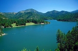
The river is impounded
by Applegate Dam several miles into Oregon, forming the 988 acres (4 km²) Applegate Lake
.
The United States Army Corps of Engineers
began construction of the dam in 1974, and it was completed in 1980. The lake nearly extends to California. The purpose of the lake is to provide irrigation
and flood control
for the Applegate Valley
.
The community of Copper
was inundated by the rising waters of the lake, and is now over 100 feet (30.5 m) below lake level.
From Applegate Dam, the river flows north and slightly east. About 8 miles (12.9 km) from California, it flows under the McKee Bridge.
The covered bridge
was built in 1917 for miner
s and loggers
. It was closed in 1956, deemed unsafe for motor vehicle
s. Restored in 1965 and 1985, the bridge is now open for pedestrian
s.
Several miles past McKee Bridge is the confluence with the Little Applegate River
. Near Ruch
, the Applegate turns and flows northwest through the unincorporated communities
of Applegate
and Provolt
. Near Provolt it passes from Jackson County
to Josephine County
. Tributaries in this area include Thompson Creek and Williams Creek, and both flow north. Williams Creek was named after Captain Robert Williams, who fought the Rogue River Indians
along the creek during the Rogue River Wars
. It flows through Williams
, also named for the captain.
From Williams Creek the Applegate turns west and flows through Murphy
. It then turns north through Wilderville
.
The river empties into the Rogue River
6 miles (9.7 km) west of Grants Pass
, just above the start of the Wild and Scenic
section of the Rogue. It discharges an average of 720 ft3/s, however as high as 47500 ft3/s was recorded in 1953, and as low as 0.78 ft3/s was recorded in 1979, when Applegate Lake was being filled.
approximately 698 mi2. Approximately 35 percent of the watershed is owned by the United States Forest Service
(as part of the Rogue River – Siskiyou National Forest), and another 35 percent by the Bureau of Land Management
. Twenty percent is private property
, while the remaining ten percent is commercial forests.
About 12,000 people live in the river's watershed in multiple town
s and farm
s, although none of the towns are incorporated
.
and madrone
.
White oak
and big-leaf maple grow in the loam
soil found on the higher slopes.
Shrub
s such as vine maple and manzanita
grow beneath the trees.
Animals that live along the Applegate River include the endangered
Siskiyou Mountains salamander
, and the near threatened
spotted owl
.
Tributary
A tributary or affluent is a stream or river that flows into a main stem river or a lake. A tributary does not flow directly into a sea or ocean...
of the Rogue River
Rogue River (Oregon)
The Rogue River in southwestern Oregon in the United States flows about in a generally westward direction from the Cascade Range to the Pacific Ocean. Known for its salmon runs, whitewater rafting, and rugged scenery, it was one of the original eight rivers named in the Wild and Scenic Rivers Act...
in the U.S. state
U.S. state
A U.S. state is any one of the 50 federated states of the United States of America that share sovereignty with the federal government. Because of this shared sovereignty, an American is a citizen both of the federal entity and of his or her state of domicile. Four states use the official title of...
of Oregon
Oregon
Oregon is a state in the Pacific Northwest region of the United States. It is located on the Pacific coast, with Washington to the north, California to the south, Nevada on the southeast and Idaho to the east. The Columbia and Snake rivers delineate much of Oregon's northern and eastern...
. It drains
Drainage basin
A drainage basin is an extent or an area of land where surface water from rain and melting snow or ice converges to a single point, usually the exit of the basin, where the waters join another waterbody, such as a river, lake, reservoir, estuary, wetland, sea, or ocean...
approximately 698 mi2. Rising in northern California
California
California is a state located on the West Coast of the United States. It is by far the most populous U.S. state, and the third-largest by land area...
, it soon crosses the border and flows northeast then northwest to meet the Rogue about 6 miles (9.7 km) west of Grants Pass
Grants Pass, Oregon
-Rogue River:The Rogue River runs through Grants Pass.-Demographics:As of the census of 2000, there were 23,003 people, 9,376 households, and 5,925 families residing in the city. The population density was . There were 9,885 housing units at an average density of 1,303.3 per square mile . By 2008,...
. It drains forested foothills of the Siskiyou Mountains
Siskiyou Mountains
The Siskiyou Mountains are a coastal mountain range in the northern Klamath Mountains in northwestern California and southwestern Oregon in the United States. They extend in an arc for approximately from east of Crescent City, California northeast along the north side of the Klamath River into...
along the Oregon–California border.
Course
The Applegate River's headwatersSource (river or stream)
The source or headwaters of a river or stream is the place from which the water in the river or stream originates.-Definition:There is no universally agreed upon definition for determining a stream's source...
are located in the Siskiyou Mountains
Siskiyou Mountains
The Siskiyou Mountains are a coastal mountain range in the northern Klamath Mountains in northwestern California and southwestern Oregon in the United States. They extend in an arc for approximately from east of Crescent City, California northeast along the north side of the Klamath River into...
in California, part of the Rogue River – Siskiyou National Forest. The water collects from snowmelt
Snowmelt
In hydrology, snowmelt is surface runoff produced from melting snow. It can also be used to describe the period or season during which such runoff is produced. Water produced by snowmelt is an important part of the annual water cycle in many parts of the world, in some cases contributing high...
and springs
Spring (hydrosphere)
A spring—also known as a rising or resurgence—is a component of the hydrosphere. Specifically, it is any natural situation where water flows to the surface of the earth from underground...
. The Siskiyou area receives between 17 inches (431.8 mm) and 40 inches (1,016 mm) of precipitation
Precipitation (meteorology)
In meteorology, precipitation In meteorology, precipitation In meteorology, precipitation (also known as one of the classes of hydrometeors, which are atmospheric water phenomena is any product of the condensation of atmospheric water vapor that falls under gravity. The main forms of precipitation...
annually.
The river then flows north through a steep canyon
Canyon
A canyon or gorge is a deep ravine between cliffs often carved from the landscape by a river. Rivers have a natural tendency to reach a baseline elevation, which is the same elevation as the body of water it will eventually drain into. This forms a canyon. Most canyons were formed by a process of...
past the Oregon-California border, receiving water from Elliot Creek.
Elliot Creek begins near Dutchman Peak in Oregon, before flowing southwest into California, roughly paralleling the border. It joins the Applegate just before it enters Oregon. This area saw major floods in 1964
Christmas flood of 1964
The Christmas flood of 1964 was a major flood that took place in the Pacific Northwest of the United States between December 18, 1964 and January 7, 1965, spanning the Christmas holiday.Considered a 100-year flood,...
and 1974, before the Applegate Dam was constructed.
The river is impounded
Dam
A dam is a barrier that impounds water or underground streams. Dams generally serve the primary purpose of retaining water, while other structures such as floodgates or levees are used to manage or prevent water flow into specific land regions. Hydropower and pumped-storage hydroelectricity are...
by Applegate Dam several miles into Oregon, forming the 988 acres (4 km²) Applegate Lake
Applegate Lake
Applegate Lake is a 988-acre reservoir located approximately from Jacksonville, Oregon, United States, and south of Applegate, Oregon, along Upper Applegate Road. The lake is an impoundment of the Applegate River....
.
The United States Army Corps of Engineers
United States Army Corps of Engineers
The United States Army Corps of Engineers is a federal agency and a major Army command made up of some 38,000 civilian and military personnel, making it the world's largest public engineering, design and construction management agency...
began construction of the dam in 1974, and it was completed in 1980. The lake nearly extends to California. The purpose of the lake is to provide irrigation
Irrigation
Irrigation may be defined as the science of artificial application of water to the land or soil. It is used to assist in the growing of agricultural crops, maintenance of landscapes, and revegetation of disturbed soils in dry areas and during periods of inadequate rainfall...
and flood control
Flood control
In communications, flood control is a feature of many communication protocols designed to prevent overwhelming of a destination receiver. Such controls can be implemented either in software or in hardware, and will often request that the message be resent after the receiver has finished...
for the Applegate Valley
Applegate Valley
Applegate Valley is the valley of the Applegate River in Southern Oregon, United States and extending slightly into Northern California. It encompasses the area between Applegate and Grants Pass, generally west of Medford...
.
The community of Copper
Copper, Jackson County, Oregon
Copper is a former community in Jackson County, Oregon, United States. Copper was located about a mile north of the Oregon-California border, near the mouth of Carberry Creek. Copper was named for the copper mining in the region, including at the Blue Ledge mine just over the state line in California...
was inundated by the rising waters of the lake, and is now over 100 feet (30.5 m) below lake level.
From Applegate Dam, the river flows north and slightly east. About 8 miles (12.9 km) from California, it flows under the McKee Bridge.
The covered bridge
Covered bridge
A covered bridge is a bridge with enclosed sides and a roof, often accommodating only a single lane of traffic. Most covered bridges are wooden; some newer ones are concrete or metal with glass sides...
was built in 1917 for miner
Miner
A miner is a person whose work or business is to extract ore or minerals from the earth. Mining is one of the most dangerous trades in the world. In some countries miners lack social guarantees and in case of injury may be left to cope without assistance....
s and loggers
Lumberjack
A lumberjack is a worker in the logging industry who performs the initial harvesting and transport of trees for ultimate processing into forest products. The term usually refers to a bygone era when hand tools were used in harvesting trees principally from virgin forest...
. It was closed in 1956, deemed unsafe for motor vehicle
Motor vehicle
A motor vehicle or road vehicle is a self-propelled wheeled vehicle that does not operate on rails, such as trains or trolleys. The vehicle propulsion is provided by an engine or motor, usually by an internal combustion engine, or an electric motor, or some combination of the two, such as hybrid...
s. Restored in 1965 and 1985, the bridge is now open for pedestrian
Pedestrian
A pedestrian is a person traveling on foot, whether walking or running. In some communities, those traveling using roller skates or skateboards are also considered to be pedestrians. In modern times, the term mostly refers to someone walking on a road or footpath, but this was not the case...
s.
Several miles past McKee Bridge is the confluence with the Little Applegate River
Little Applegate River
The Little Applegate River is a long tributary of the Applegate River located in the U.S. state of Oregon. It is part of the Rogue River watershed, draining approximately of Jackson County...
. Near Ruch
Ruch, Oregon
Ruch is an unincorporated community in Jackson County, Oregon, United States. It is located on Oregon Route 238, southeast of Grants Pass.Ruch was named for Casper M. Ruch, who bought a tract of land where the community now stands in 1896. He built a blacksmith shop, a store and a house...
, the Applegate turns and flows northwest through the unincorporated communities
Unincorporated area
In law, an unincorporated area is a region of land that is not a part of any municipality.To "incorporate" in this context means to form a municipal corporation, a city, town, or village with its own government. An unincorporated community is usually not subject to or taxed by a municipal government...
of Applegate
Applegate, Oregon
Applegate is an unincorporated community in Jackson County, Oregon, United States. It is located west of Medford on Oregon Route 238 and the Applegate River...
and Provolt
Provolt, Oregon
Provolt is an unincorporated community in Jackson County, Oregon, United States. It is located about 15 miles southeast of Grants Pass on Oregon Route 238, near the Applegate River on the county line between Jackson and Josephine counties....
. Near Provolt it passes from Jackson County
Jackson County, Oregon
-National protected areas:* Cascade–Siskiyou National Monument* Crater Lake National Park * Klamath National Forest * Rogue River-Siskiyou National Forest * Umpqua National Forest -Demographics:...
to Josephine County
Josephine County, Oregon
Josephine County is a county located in the U.S. state of Oregon. According to Oregon Geographic Names, the county is probably named after a stream in the area called Josephine Creek, which in turn is probably named after Virginia Josephine Rollins Ort. In 2010, its population was 82,713...
. Tributaries in this area include Thompson Creek and Williams Creek, and both flow north. Williams Creek was named after Captain Robert Williams, who fought the Rogue River Indians
Rogue River (tribe)
Rogue River is the name of a Native American group originally located in southern Oregon in the United States. Rogue River was not a single tribe, but a conglomeration of many affiliated and related tribal groups. The total estimated population of these tribes in 1850 was about 9,500...
along the creek during the Rogue River Wars
Rogue River Wars
The Rogue River Wars was an armed conflict between the US Army, local militias and volunteers, and the Native American tribes commonly grouped under the designation of Rogue River Indians, in the Rogue River Valley area of what today is southern Oregon in 1855–56...
. It flows through Williams
Williams, Oregon
Williams is an unincorporated community in Josephine County, Oregon, United States.There were three different post offices in the area named for their proximity to Williams Creek: Williams, Williamsburg and Williams Creek...
, also named for the captain.
From Williams Creek the Applegate turns west and flows through Murphy
Murphy, Oregon
Murphy is an unincorporated community in Josephine County, Oregon, United States. The Three Rivers School District is located there.Although Murphy is unincorporated, it has a post office with ZIP code 97533.-References:...
. It then turns north through Wilderville
Wilderville, Oregon
Wilderville is an unincorporated community in Josephine County, Oregon, United States. Wilderville is located along U.S. Route 199 southwest of Grants Pass. Wilderville has a post office with ZIP code 97543....
.
The river empties into the Rogue River
Rogue River (Oregon)
The Rogue River in southwestern Oregon in the United States flows about in a generally westward direction from the Cascade Range to the Pacific Ocean. Known for its salmon runs, whitewater rafting, and rugged scenery, it was one of the original eight rivers named in the Wild and Scenic Rivers Act...
6 miles (9.7 km) west of Grants Pass
Grants Pass, Oregon
-Rogue River:The Rogue River runs through Grants Pass.-Demographics:As of the census of 2000, there were 23,003 people, 9,376 households, and 5,925 families residing in the city. The population density was . There were 9,885 housing units at an average density of 1,303.3 per square mile . By 2008,...
, just above the start of the Wild and Scenic
National Wild and Scenic River
National Wild and Scenic River is a designation for certain protected areas in the United States.The National Wild and Scenic Rivers Act was an outgrowth of the recommendations of a Presidential commission, the Outdoor Recreation Resources Review Commission...
section of the Rogue. It discharges an average of 720 ft3/s, however as high as 47500 ft3/s was recorded in 1953, and as low as 0.78 ft3/s was recorded in 1979, when Applegate Lake was being filled.
Watershed
The Applegate River drainsDrainage basin
A drainage basin is an extent or an area of land where surface water from rain and melting snow or ice converges to a single point, usually the exit of the basin, where the waters join another waterbody, such as a river, lake, reservoir, estuary, wetland, sea, or ocean...
approximately 698 mi2. Approximately 35 percent of the watershed is owned by the United States Forest Service
United States Forest Service
The United States Forest Service is an agency of the United States Department of Agriculture that administers the nation's 155 national forests and 20 national grasslands, which encompass...
(as part of the Rogue River – Siskiyou National Forest), and another 35 percent by the Bureau of Land Management
Bureau of Land Management
The Bureau of Land Management is an agency within the United States Department of the Interior which administers America's public lands, totaling approximately , or one-eighth of the landmass of the country. The BLM also manages of subsurface mineral estate underlying federal, state and private...
. Twenty percent is private property
Property
Property is any physical or intangible entity that is owned by a person or jointly by a group of people or a legal entity like a corporation...
, while the remaining ten percent is commercial forests.
About 12,000 people live in the river's watershed in multiple town
Town
A town is a human settlement larger than a village but smaller than a city. The size a settlement must be in order to be called a "town" varies considerably in different parts of the world, so that, for example, many American "small towns" seem to British people to be no more than villages, while...
s and farm
Farm
A farm is an area of land, or, for aquaculture, lake, river or sea, including various structures, devoted primarily to the practice of producing and managing food , fibres and, increasingly, fuel. It is the basic production facility in food production. Farms may be owned and operated by a single...
s, although none of the towns are incorporated
Municipal corporation
A municipal corporation is the legal term for a local governing body, including cities, counties, towns, townships, charter townships, villages, and boroughs. Municipal incorporation occurs when such municipalities become self-governing entities under the laws of the state or province in which...
.
Flora and fauna
The most common trees within the Applegate River's watershed include Douglas firCoast Douglas-fir
Pseudotsuga menziesii, known as Douglas-fir, Oregon Pine, or Douglas spruce, is an evergreen conifer species native to western North America. Its variety Pseudotsuga menziesii var. menziesii, also known as coast Douglas-fir grows in the coastal regions, from west-central British Columbia, Canada...
and madrone
Pacific Madrone
Arbutus menziesii, commonly known as the Pacific Madrone, is a species of Arbutus found on the west coast of North America, from British Columbia to California...
.
White oak
White oak
Quercus alba, the white oak, is one of the pre-eminent hardwoods of eastern North America. It is a long-lived oak of the Fagaceae family, native to eastern North America and found from southern Quebec west to eastern Minnesota and south to northern Florida and eastern Texas. Specimens have been...
and big-leaf maple grow in the loam
Loam
Loam is soil composed of sand, silt, and clay in relatively even concentration . Loam soils generally contain more nutrients and humus than sandy soils, have better infiltration and drainage than silty soils, and are easier to till than clay soils...
soil found on the higher slopes.
Shrub
Shrub
A shrub or bush is distinguished from a tree by its multiple stems and shorter height, usually under 5–6 m tall. A large number of plants may become either shrubs or trees, depending on the growing conditions they experience...
s such as vine maple and manzanita
Arctostaphylos viscida
Arctostaphylos viscida, with the common names Whiteleaf manzanita and Sticky manzanita, is a species of manzanita.-Distribution:...
grow beneath the trees.
Animals that live along the Applegate River include the endangered
Endangered species
An endangered species is a population of organisms which is at risk of becoming extinct because it is either few in numbers, or threatened by changing environmental or predation parameters...
Siskiyou Mountains salamander
Siskiyou Mountains salamander
The Siskiyou Mountains salamander, Plethodon stormi, also called the Siskiyou Mountain salamander, exists only in isolated locations along the Klamath River in northern California and southern Oregon...
, and the near threatened
Near Threatened
Near Threatened is a conservation status assigned to species or lower taxa that may be considered threatened with extinction in the near future, although it does not currently qualify for the threatened status...
spotted owl
Spotted Owl
The Spotted Owl, Strix occidentalis, is a species of true owl. It is a resident species of forests in western North America, where it nests in tree holes, old bird of prey nests, or rock crevices. Nests can be between 13 and 66 yards high and usually contain two eggs...
.
See also
- List of rivers of Oregon
- List of longest streams of Oregon
- Northern CaliforniaNorthern CaliforniaNorthern California is the northern portion of the U.S. state of California. The San Francisco Bay Area , and Sacramento as well as its metropolitan area are the main population centers...
- Southern OregonSouthern OregonSouthern Oregon is a region of the U.S. state of Oregon south of Lane County and generally west of the Cascade Range, excluding the southern Oregon Coast. Counties include Douglas, Jackson, Klamath, and Josephine. It includes the Southern Oregon American Viticultural Area, which consists of the...