
Donner und Blitzen River
Encyclopedia

Oregon
Oregon is a state in the Pacific Northwest region of the United States. It is located on the Pacific coast, with Washington to the north, California to the south, Nevada on the southeast and Idaho to the east. The Columbia and Snake rivers delineate much of Oregon's northern and eastern...
high desert which drains a relatively arid basin, the southern portion of Harney Basin
Harney Basin
The Harney Basin is a structural basin in southeastern Oregon in the United States at the northwestern corner of the Great Basin. One of the least populated areas of the contiguous United States, it is located largely in northern Harney County, bounded on the north and east by the Columbia Plateau,...
, from roughly 20 to 80 miles (30 to 130 km) south-southeast of Burns
Burns, Oregon
Burns is a city in and the county seat of Harney County, Oregon, United States. As of the 2010 census the population was 2,806.-History:Burns was established in the early 1880s and incorporated upon Harney county's creation in 1889...
including Malheur National Wildlife Refuge
Malheur National Wildlife Refuge
Malheur National Wildlife Refuge is located roughly south of the town of Burns, Oregon. The refuge area is roughly T shaped with the southernmost base at Frenchglen, the left top at Malheur Lake and the right top at Harney Lake....
. Though much of its course is marsh, it offers scenic glaciated canyons, unique ecosystems, and exceptional wild trout fisheries. Named by soldiers of German
Germany
Germany , officially the Federal Republic of Germany , is a federal parliamentary republic in Europe. The country consists of 16 states while the capital and largest city is Berlin. Germany covers an area of 357,021 km2 and has a largely temperate seasonal climate...
origin, the Donner und Blitzen River translates as "thunder and lightning" and brings to mind two of Santa Claus's reindeer.
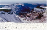
The Donner und Blitzen River arises as an intermittent stream on the lower slopes west of Steens Mountain
Steens Mountain
Steens Mountain is a large fault-block mountain in the southeastern part of the U.S. state of Oregon. Located in Harney County, it stretches some and rises from an elevation of about above the Alvord Desert to its peak at...
at the 6500 feet (1,981.2 m) level at 42.5337785°N 118.7310228°W, roughly 80 miles (128.7 km) south-southeast of Burns
Burns, Oregon
Burns is a city in and the county seat of Harney County, Oregon, United States. As of the 2010 census the population was 2,806.-History:Burns was established in the early 1880s and incorporated upon Harney county's creation in 1889...
and 11 miles (17.7 km) northwest of Alvord Lake
Alvord Lake (Oregon)
Alvord Lake is a seasonal shallow alkali lake in Harney County of the U.S. state of Oregon. Its elevation is . It is located about southeast of Alvord Desert in the Alvord Basin and serves as terminus for all its streams. Its water level varies from dry to several feet deep...
and empties at 43.291542°N 118.8199273°W into Malheur Lake
Malheur Lake
Malheur Lake is a lake in an arid region of eastern Oregon, United States near Burns, Oregon. The lake is fed by Donner und Blitzen River from the south and the Silvies River from the north. Malheur Lake has no outlet, though water escapes through ground seepage and by evaporation; widespread...
. Numerous nearby springs create its tributaries including South Fork Blitzen River, Little Blitzen River
Little Blitzen River
Little Blitzen River is a tributary of the Donner und Blitzen River in the U.S. state of Oregon. Little Blitzen River rises on the west flank of Steens Mountain about southeast of Frenchglen and about south of Burns in Harney County...
, Big Indian Creek, Little Indian Creek, Fish Creek, Mud Creek, and Ankle Creek. It collects these and runs north or northwest descending rapidly to the plateau floor then turns northward to Malheur Lake which has no outlet. It does not pass through any cities, though it comes within 2 miles (3.2 km) of Frenchglen
Frenchglen, Oregon
Frenchglen is an unincorporated community in Harney County, Oregon, United States. It is south of Burns on Oregon Route 205 and its population is approximately 12....
.
In 1988, 72.7 miles (117 km) of rivers in its basin were designated Wild and Scenic
National Wild and Scenic River
National Wild and Scenic River is a designation for certain protected areas in the United States.The National Wild and Scenic Rivers Act was an outgrowth of the recommendations of a Presidential commission, the Outdoor Recreation Resources Review Commission...
, and another 14.8 miles (23.8 km) were added in 2000. The Oregon Department of Environmental Quality
Oregon Department of Environmental Quality
The Oregon Department of Environmental Quality is the chief regulatory agency of the government of the U.S. state of Oregon responsible for protecting and enhancing the state's natural resources and managing sanitary and toxic waste disposal. The agency employs approximately 700 scientists,...
(DEQ) lists seven temperature impairments on the river system. The maximum recorded flow of 4270 cuft/s occurred on April 26, 1978, and was extrapolated from a calibrated value of 1900 cuft/s. The minimum recorded flow 4.2 cuft/s occurred December 9, 1972, caused by widespread freezing.
See also
- List of rivers of Oregon
- List of longest streams of Oregon
- List of National Wild and Scenic Rivers
- Harney BasinHarney BasinThe Harney Basin is a structural basin in southeastern Oregon in the United States at the northwestern corner of the Great Basin. One of the least populated areas of the contiguous United States, it is located largely in northern Harney County, bounded on the north and east by the Columbia Plateau,...
External links
- Donner und Blitzen River - Oregon Natural Desert Association
- Little Blitzen River and Bridge Creek Remote Sensing Survey