
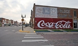
Council Grove, Kansas
Encyclopedia
Council Grove is a city in Morris County
, Kansas
, United States
. It was named after an agreement between European Americans and the Osage Nation
about allowing settlers' wagon trains to pass through the area and proceed to the West. Pioneers gathered at a grove of trees so that wagons could band together for their trip west. It is the county seat
of Morris County
. As of the 2010 census, the city population was 2,182.
 Council Grove was one of the last stops on the Santa Fe Trail
heading southwest. The first European-American settler was Seth Hays, who came to the area in 1847 to trade with the Kaw tribe
, which had a reservation established in the area in 1846. Hays was a grandson of Daniel Boone
. In 1858, the town was officially incorporated by the legislature. Hays also opened a restaurant in 1857, the Hays House, which is said to be the oldest continuously operating restaurant west of the Mississippi River
.
The town has 13 sites listed on the National Register of Historic Places
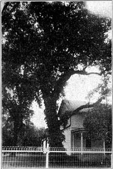
. One is the Post Office Oak. Travelers left their mail in this designated tree to be picked up by others going in the right direction. General Custer of the United States Army
slept here with his troops during the American Civil War
, under a large tree known now as the Custer Elm.
The National Old Trails Road, also known as the Ocean-to-Ocean Highway, was established in 1912, and was routed through Herington
, Delavan, Council Grove.
In 1943, German and Italian prisoners of World War II
were brought to Kansas and other Midwest states as a means of solving the labor shortage caused by American men serving in the war effort. Large internment
camps were established in Kansas: Camp Concordia
, Camp Funston (at Fort Riley
), Camp Phillips (at Salina
under Fort Riley
). Fort Riley
established 12 smaller branch camps, including Council Grove.
Presently, both the Council Grove Reservoir and the City Lake are popular for recreational activities. While both lakes are open to the public and motorized boats, most of the land around the City Lake is privately owned with over three hundred lake houses. Building is restricted on the larger Council Grove Reservoir but there are many well-positioned camp sites. Excellent fishing is found on these lakes as well. Walleye, crappie, white bass, and many more fish are in both the Council Grove Reservoir and the City Lake.
, the city has a total area of 1.8 square miles (4.7 km²), all of it land.
 As of the census
of 2000, there were 2,321 people, 1,002 households, and 634 families residing in the city. The population density
was 1,293.2 people per square mile (500.6/km²). There were 1,099 housing units at an average density of 612.3 per square mile (237.1/km²). The racial makeup of the city was 98.23% White, 0.26% African American, 0.22% Native American, 0.22% Asian, 0.47% from other races
, and 0.60% from two or more races. Hispanic or Latino of any race were 2.11% of the population.
There were 1,002 households out of which 29.0% had children under the age of 18 living with them, 51.3% were married couples
living together, 8.7% had a female householder with no husband present, and 36.7% were non-families. 34.8% of all households were made up of individuals and 19.0% had someone living alone who was 65 years of age or older. The average household size was 2.24 and the average family size was 2.90.
In the city the population was spread out with 24.7% under the age of 18, 6.5% from 18 to 24, 23.8% from 25 to 44, 21.7% from 45 to 64, and 23.4% who were 65 years of age or older. The median age was 42 years. For every 100 females there were 89.2 males. For every 100 females age 18 and over, there were 82.8 males.
The median income for a household in the city was $28,949, and the median income for a family was $37,061. Males had a median income of $29,500 versus $20,625 for females. The per capita income
for the city was $20,189. About 7.4% of families and 8.5% of the population were below the poverty line, including 8.7% of those under age 18 and 15.6% of those age 65 or over.
417. Council Grove High School
is a high school located at 129 Hockaday St., Council Grove. Students from the surrounding areas of Dwight, Alta Vista, and Wilsey travel to Council Grove to attend high school. Council Grove Middle School includes grades 6 through 8 and is located at 706 E Main St. Council Grove Elementary School includes kindergarten through the 5th grade and is attached to the middle school. The athletic teams are known as the Braves.
Kansas
USA
Schools
Historical
Maps
Morris County, Kansas
Morris County is a county located in the U.S. state of Kansas. As of the 2010 census, the county population was 5,923. The largest city and county seat is Council Grove.-19th century:...
, Kansas
Kansas
Kansas is a US state located in the Midwestern United States. It is named after the Kansas River which flows through it, which in turn was named after the Kansa Native American tribe, which inhabited the area. The tribe's name is often said to mean "people of the wind" or "people of the south...
, United States
United States
The United States of America is a federal constitutional republic comprising fifty states and a federal district...
. It was named after an agreement between European Americans and the Osage Nation
Osage Nation
The Osage Nation is a Native American Siouan-language tribe in the United States that originated in the Ohio River valley in present-day Kentucky. After years of war with invading Iroquois, the Osage migrated west of the Mississippi River to their historic lands in present-day Arkansas, Missouri,...
about allowing settlers' wagon trains to pass through the area and proceed to the West. Pioneers gathered at a grove of trees so that wagons could band together for their trip west. It is the county seat
County seat
A county seat is an administrative center, or seat of government, for a county or civil parish. The term is primarily used in the United States....
of Morris County
Morris County, Kansas
Morris County is a county located in the U.S. state of Kansas. As of the 2010 census, the county population was 5,923. The largest city and county seat is Council Grove.-19th century:...
. As of the 2010 census, the city population was 2,182.
History
Santa Fe Trail
The Santa Fe Trail was a 19th-century transportation route through central North America that connected Missouri with Santa Fe, New Mexico. Pioneered in 1822 by William Becknell, it served as a vital commercial and military highway until the introduction of the railroad to Santa Fe in 1880...
heading southwest. The first European-American settler was Seth Hays, who came to the area in 1847 to trade with the Kaw tribe
Kaw (tribe)
The Kaw Nation are an American Indian people of the central Midwestern United States. The tribe known as Kaw have also been known as the "People of the South wind", "People of water", Kansa, Kaza, Kosa, and Kasa. Their tribal language is Kansa, classified as a Siouan language.The toponym "Kansas"...
, which had a reservation established in the area in 1846. Hays was a grandson of Daniel Boone
Daniel Boone
Daniel Boone was an American pioneer, explorer, and frontiersman whose frontier exploits mad']'e him one of the first folk heroes of the United States. Boone is most famous for his exploration and settlement of what is now the Commonwealth of Kentucky, which was then beyond the western borders of...
. In 1858, the town was officially incorporated by the legislature. Hays also opened a restaurant in 1857, the Hays House, which is said to be the oldest continuously operating restaurant west of the Mississippi River
Mississippi River
The Mississippi River is the largest river system in North America. Flowing entirely in the United States, this river rises in western Minnesota and meanders slowly southwards for to the Mississippi River Delta at the Gulf of Mexico. With its many tributaries, the Mississippi's watershed drains...
.
The town has 13 sites listed on the National Register of Historic Places
National Register of Historic Places
The National Register of Historic Places is the United States government's official list of districts, sites, buildings, structures, and objects deemed worthy of preservation...
. One is the Post Office Oak. Travelers left their mail in this designated tree to be picked up by others going in the right direction. General Custer of the United States Army
United States Army
The United States Army is the main branch of the United States Armed Forces responsible for land-based military operations. It is the largest and oldest established branch of the U.S. military, and is one of seven U.S. uniformed services...
slept here with his troops during the American Civil War
American Civil War
The American Civil War was a civil war fought in the United States of America. In response to the election of Abraham Lincoln as President of the United States, 11 southern slave states declared their secession from the United States and formed the Confederate States of America ; the other 25...
, under a large tree known now as the Custer Elm.
The National Old Trails Road, also known as the Ocean-to-Ocean Highway, was established in 1912, and was routed through Herington
Herington, Kansas
Herington is a city in Dickinson and Morris counties in the U.S. state of Kansas. Named after its founder, Monroe Davis Herington. As of the 2010 census, the city population was 2,526.-19th century:...
, Delavan, Council Grove.
In 1943, German and Italian prisoners of World War II
World War II
World War II, or the Second World War , was a global conflict lasting from 1939 to 1945, involving most of the world's nations—including all of the great powers—eventually forming two opposing military alliances: the Allies and the Axis...
were brought to Kansas and other Midwest states as a means of solving the labor shortage caused by American men serving in the war effort. Large internment
Internment
Internment is the imprisonment or confinement of people, commonly in large groups, without trial. The Oxford English Dictionary gives the meaning as: "The action of 'interning'; confinement within the limits of a country or place." Most modern usage is about individuals, and there is a distinction...
camps were established in Kansas: Camp Concordia
Camp Concordia
Camp Concordia was a Prisoner-of-war camp that operated from 1943-1945. Its location is two miles north and one mile east of Concordia, Kansas...
, Camp Funston (at Fort Riley
Fort Riley
Fort Riley is a United States Army installation located in Northeast Kansas, on the Kansas River, between Junction City and Manhattan. The Fort Riley Military Reservation covers 100,656 acres in Geary and Riley counties and includes two census-designated places: Fort Riley North and Fort...
), Camp Phillips (at Salina
Salina, Kansas
Salina is a city in and the county seat of Saline County, Kansas, United States. As of the 2010 census, the city population was 47,707. Located in one of the world's largest wheat-producing areas, Salina is a regional trade center for north-central Kansas...
under Fort Riley
Fort Riley
Fort Riley is a United States Army installation located in Northeast Kansas, on the Kansas River, between Junction City and Manhattan. The Fort Riley Military Reservation covers 100,656 acres in Geary and Riley counties and includes two census-designated places: Fort Riley North and Fort...
). Fort Riley
Fort Riley
Fort Riley is a United States Army installation located in Northeast Kansas, on the Kansas River, between Junction City and Manhattan. The Fort Riley Military Reservation covers 100,656 acres in Geary and Riley counties and includes two census-designated places: Fort Riley North and Fort...
established 12 smaller branch camps, including Council Grove.
Presently, both the Council Grove Reservoir and the City Lake are popular for recreational activities. While both lakes are open to the public and motorized boats, most of the land around the City Lake is privately owned with over three hundred lake houses. Building is restricted on the larger Council Grove Reservoir but there are many well-positioned camp sites. Excellent fishing is found on these lakes as well. Walleye, crappie, white bass, and many more fish are in both the Council Grove Reservoir and the City Lake.
Geography
Council Grove is located at 38°39′38"N 96°29′23"W (38.660678, -96.489672). According to the United States Census BureauUnited States Census Bureau
The United States Census Bureau is the government agency that is responsible for the United States Census. It also gathers other national demographic and economic data...
, the city has a total area of 1.8 square miles (4.7 km²), all of it land.
Area events
Area attractions
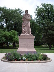
- Allegawaho Heritage Memorial Park
- Kaw Mission, state historic site.
- 1857 Hays House
- Madonna of the TrailMadonna of the TrailMadonna of the Trail is a series of 12 monuments dedicated to the spirit of pioneer women in the United States. The monuments were commissioned by the National Society of Daughters of the American Revolution...
monument
Demographics
Census
A census is the procedure of systematically acquiring and recording information about the members of a given population. It is a regularly occurring and official count of a particular population. The term is used mostly in connection with national population and housing censuses; other common...
of 2000, there were 2,321 people, 1,002 households, and 634 families residing in the city. The population density
Population density
Population density is a measurement of population per unit area or unit volume. It is frequently applied to living organisms, and particularly to humans...
was 1,293.2 people per square mile (500.6/km²). There were 1,099 housing units at an average density of 612.3 per square mile (237.1/km²). The racial makeup of the city was 98.23% White, 0.26% African American, 0.22% Native American, 0.22% Asian, 0.47% from other races
Race (United States Census)
Race and ethnicity in the United States Census, as defined by the Federal Office of Management and Budget and the United States Census Bureau, are self-identification data items in which residents choose the race or races with which they most closely identify, and indicate whether or not they are...
, and 0.60% from two or more races. Hispanic or Latino of any race were 2.11% of the population.
There were 1,002 households out of which 29.0% had children under the age of 18 living with them, 51.3% were married couples
Marriage
Marriage is a social union or legal contract between people that creates kinship. It is an institution in which interpersonal relationships, usually intimate and sexual, are acknowledged in a variety of ways, depending on the culture or subculture in which it is found...
living together, 8.7% had a female householder with no husband present, and 36.7% were non-families. 34.8% of all households were made up of individuals and 19.0% had someone living alone who was 65 years of age or older. The average household size was 2.24 and the average family size was 2.90.
In the city the population was spread out with 24.7% under the age of 18, 6.5% from 18 to 24, 23.8% from 25 to 44, 21.7% from 45 to 64, and 23.4% who were 65 years of age or older. The median age was 42 years. For every 100 females there were 89.2 males. For every 100 females age 18 and over, there were 82.8 males.
The median income for a household in the city was $28,949, and the median income for a family was $37,061. Males had a median income of $29,500 versus $20,625 for females. The per capita income
Per capita income
Per capita income or income per person is a measure of mean income within an economic aggregate, such as a country or city. It is calculated by taking a measure of all sources of income in the aggregate and dividing it by the total population...
for the city was $20,189. About 7.4% of families and 8.5% of the population were below the poverty line, including 8.7% of those under age 18 and 15.6% of those age 65 or over.
Primary and secondary education
Council Grove is part of Unified School DistrictUnified school district
A unified school district or unit school district is a school district which includes both primary school and high school under the same district control....
417. Council Grove High School
Council Grove High School
Council Grove High School is a fully accredited public high school located in Council Grove, Kansas, USA, serving students in grades 9-12. The school educates approximately 226 students. The principal is Kelly McDiffett. The school mascot is the Brave and the school colors are blue and yellow...
is a high school located at 129 Hockaday St., Council Grove. Students from the surrounding areas of Dwight, Alta Vista, and Wilsey travel to Council Grove to attend high school. Council Grove Middle School includes grades 6 through 8 and is located at 706 E Main St. Council Grove Elementary School includes kindergarten through the 5th grade and is attached to the middle school. The athletic teams are known as the Braves.
Transporation
Council Grove was located on the National Old Trails Road, also known as the Ocean-to-Ocean Highway, that was established in 1912.See also
- National Register of Historic Places listings in Morris County, KansasNational Register of Historic Places listings in Morris County, KansasThis is a list of the National Register of Historic Places listings in Morris County, Kansas.This is intended to be a complete list of the properties and districts on the National Register of Historic Places in Morris County, Kansas, United States...
- Council Grove Historic District
- Santa Fe TrailSanta Fe TrailThe Santa Fe Trail was a 19th-century transportation route through central North America that connected Missouri with Santa Fe, New Mexico. Pioneered in 1822 by William Becknell, it served as a vital commercial and military highway until the introduction of the railroad to Santa Fe in 1880...
- National Old Trails Road
Further reading
- Historical information about Council Grove
- Biographical information on Seth Hays
- Santa Fe Trail Research
Kansas
- History of the State of Kansas; William G. Cutler; A.T. Andreas Publisher; 1883. (Online HTML eBook)
- Kansas : A Cyclopedia of State History, Embracing Events, Institutions, Industries, Counties, Cities, Towns, Prominent Persons, Etc; 3 Volumes; Frank W. Blackmar; Standard Publishing Co; 944 / 955 / 824 pages; 1912. (Volume1 - Download 54MB PDF eBook),(Volume2 - Download 53MB PDF eBook), (Volume3 - Download 33MB PDF eBook)
USA
- The Story of the Marking of the Santa Fe TrailSanta Fe TrailThe Santa Fe Trail was a 19th-century transportation route through central North America that connected Missouri with Santa Fe, New Mexico. Pioneered in 1822 by William Becknell, it served as a vital commercial and military highway until the introduction of the railroad to Santa Fe in 1880...
by the Daughters of the American RevolutionDaughters of the American RevolutionThe Daughters of the American Revolution is a lineage-based membership organization for women who are descended from a person involved in United States' independence....
in Kansas and the State of Kansas; Almira Cordry; Crane Co; 164 pages; 1915. (Download 4MB PDF eBook) - The National Old Trails Road To Southern California, Part 1 (LA to KC); Automobile Club Of Southern California; 64 pages; 1916. (Download 6.8MB PDF eBook)
External links
CitySchools
- USD 417, local school district
Historical
Maps
- Council Grove City Map, KDOT
- Morris County Map, KDOT