
Kirkcudbrightshire
Encyclopedia
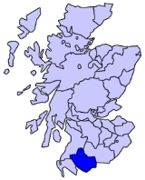
The Stewartry of Kirkcudbright (icon ; Siorrachd Chille Chuithbheirt in Gaelic) or Kirkcudbrightshire (k ) was a county
of south-western Scotland
. It was also known as East Galloway, forming the larger Galloway
region with Wigtownshire
.
Kirkcudbrightshire bounded on the north and north-west by Ayrshire
, on the west and southwest by Wigtownshire
, on the south and southeast by the Irish Sea
and the Solway Firth
, and on the east and northeast by Dumfriesshire
. It included the small islands of Hestan
and Little Ross
. It had an area of 575,565 acres (2,323 km²). That area is now part of the unitary authority
of Dumfries and Galloway
, and is additionally administratively used for property registration
.
In 1372 Archibald the Grim, a natural son of Sir James Douglas
"the Good", became Lord of Galloway and received in perpetual fee the Crown lands between the Nith
and the Cree
. He appointed a steward
to collect his revenues and administer justice, and there thus arose the designation of the "Stewartry of Kirkcudbright" (see History below).
The county is still called The Stewartry by its inhabitants and forms the Stewartry area of Dumfries and Galloway Council, represented by eight Stewartry councillors. Local administration of the district today is overseen by a Stewartry Area Manager, based in the county town of Kirkcudbright.
The name Kirkcudbrightshire (or "Kircudbright-Shire") as alternative to Stewartry of Kirkcudbright appears from an early date, noticeably on the maps of Herman Moll
in the mid-eighteenth century.
In this quarter the principal mountains are Merrick
843 m (2764 ft), the highest in the south of Scotland, and the group of the Rhinns of Kells, the chief peaks of which are Corserine
814 m (2669 ft), Carlins Cairn 807 m (2650 ft), Meikle Millyea 746 m (2446 ft) and Millfire 716 m (2350 ft). Towards the south-west the chief eminences are Lamachan Hill
717 (2350 ft), Larg 676 m (2216 ft), and the bold mass of Cairnsmore of Fleet
711 m (2331 ft). In the south-east the only imposing height is Criffel 569 m (1868 ft). In the north rises the majestic hill of Cairnsmore of Carsphairn
797 m (2614 ft), and close to the Ayrshire border is the Windy Standard 698 m (2290 ft). The southern section of the shire is mostly level or undulating, but characterised by picturesque scenery.
The shore is generally bold and rocky, indented by numerous estuaries forming natural harbours, which however are of little use for commerce
owing to the shallowness of the sea. Large stretches of sand are exposed in the Solway at low water and the rapid flow of the tide has often occasioned loss of life.
The number of "burns" and "waters" is remarkable, but their length seldom exceeds 7 or 8 miles (13 km). Among the longer rivers are the Cree, which rises in Loch Moan and reaches the sea near Creetown after a course of about 30 miles (48.3 km), during which it forms the boundary, at first of Ayrshire
and then of Wigtownshire
; the Dee or Black Water of Dee (so named from the peat by which it is coloured), which rises in Loch Dee and after a course mainly S.E. and finally S., enters the sea at St Mary's Isle
below Kirkcudbright
, its length being nearly 36 miles (58 km); the Urr, rising in Loch Urr on the Dumfriesshire
border, falls into the sea a few miles south of Dalbeattie
27 miles (43 km) from its source; the Ken
, rising on the confines of Ayrshire, flows mainly in a southerly direction and joins the Dee at the southern end of Loch Ken
after a course of 24 miles (39 km) through lovely scenery; and the Deugh which, rising on the northern flank of the Windy Standard, pursues an extraordinarily winding course of 20 miles (32 km) before reaching the Ken. The Nith
, during the last few miles of its flow, forms the boundary with Dumfriesshire, to which county it almost wholly belongs.
The lochs and mountain tarns are many and well-distributed; but except for Loch Ken, which is about 6 miles (10 km) long by half a mile (1 km) wide, few of them attain noteworthy dimensions. There are several passes in the hill regions, but the only well-known glen is Glen Trool
, not far from the district of Carrick
in Ayrshire, the fame of which rests partly on the romantic character of its scenery, which is very wild around Loch Trool
, and more especially on its associations with Robert the Bruce
. It was here that when most closely beset by his enemies, who had tracked him to his fastness by sleuth hounds, Bruce with the aid of a few faithful followers won a surprise victory over the English in 1307 which proved the turning-point of his fortunes.
and Ordovician
rocks are the most important in this county; they are thrown into oft-repeated folds with their axes lying in a northeast-southwest direction. The Ordovician rocks are graptolitic black shales and grits of Llandeilo and Caradoc age. They occupy all the northern part of the county north-west of a line which runs some 3 m. north of New Galloway and just south of the Rinns of Kells. South-east of this line graptolitic Silurian shales of Llandovery age prevail; they are found around Dalry, Creetown, New Galloway, Castle Douglas and Kirkcudbright.
Overlying the Llandovery beds on the south coast are strips of Wenlock rocks; they extend from Bridgehouse Bay to Auchinleck
and are well exposed in Kirkcudbright Bay, and they can be traced farther round the coast between the granite and the younger rocks. Carboniferous
rocks appear in small faulted tracts, unconformable on the Silurian, on the shores of the Solway Firth. They are best developed about Kirkbean, where they include a basal red breccia
followed by conglomerates, grits and cement stones of Calciferous Sandstone
age.
Brick-red sandstones of Permian
age just come within the county on the W. side of the Nith at Dumfries. Volcanic necks occur in the Permian and basalt dikes penetrate the Silurian at Borgue, Kirkandrews, etc.
Most of the highest ground is formed by the masses of granite
which have been intruded into the Ordovician and Silurian rocks; the Criffel mass lies about Dalbeattie
and Bengairn, another mass extends east and west between the Cairnsmore of Fleet and Loch Ken
, another lies northwest and southeast between Loch Doon
and Loch Dee and a small mass forms the Cairnsmore of Carsphairn
.
Glacial deposits occupy much of the low ground; the ice, having travelled in a southerly or south-easterly direction, has left abundant striae on the higher ground to indicate its course. Radiation of the ice streams took place from the heights of Merrick, Kells, etc.; local moraines are found near Carsphairn
and in the Deagh and Minnoch valleys. Glacial drumlin
s of boulder clay lie in the vales of the Dee, Cree and Urr.
has never been enquired of in a census. It is declining rapidly but was formerly relatively widespread.
In order of size the chief towns are:-
Other notable towns and villages include:-
The county forms part of the sheriffdom of Dumfries and Galloway.
In 1930 Maxwelltown
(population 1901: 5796) was transferred to Dumfriesshire. It is now a suburb of the town of Dumfries
so it is debatable whether it should be regarded as part of the geographical county of Kirkcudbrightshire.
's invasion in AD 79
the country nominally formed part of the Roman
province of Britannia
, but the evidence is against there ever having been a prolonged effective Roman occupation. The view that there were Picts
in Galloway in historical times is now rejected.
After the retreat of the Romans the fate of the Novantae is unknown but by the 6th century Galloway was part of the Brythonic
kingdom of Rheged
. By the 7th century much of Galloway became part of the English
kingdom of Northumbria
.
After the Norsemen
conquered southern the fate of the rest of the kingdom is unclear. It is likely that Galloway became part of the Kingdom of Strathclyde
. There was significant immigration into Galloway in later centuries from Ireland
by the Hiberno-Norse Gallgaidhel, or "stranger Gaels", the Welsh equivalent for which, Galiwyddel, gave rise to the name of "Galloway" (of which Galway
is a variant). The name Galloway was applied to their territory and still denotes the Stewartry of Kirkcudbright and the shire of Wigtown
. (It has been argued inconclusively that the Gallgaidhael were only a warrior aristocracy on top of an existing Anglo-Saxon / Brythonic population.)
When Scotland consolidated under Kenneth MacAlpine
(crowned at Scone in 844), Galloway did not form part of the kingdom; but in return for the services rendered to him at this crisis Kenneth gave his daughter in marriage to the Galloway chief, Olaf the White
, and also conferred upon the men of Galloway the privilege of marching in the van of the Scottish armies, a right exercised and recognized for several centuries.
During the next two hundred years the country had no rest from Danish and Saxon incursions and the continual lawlessness of the Scandinavian rovers. When Malcolm Canmore
defeated and slew Macbeth in 1057 he married the dead king's relative Ingibiorg, a Pictish princess, an event which marked the beginning of the decay of Norse influence. The Galloway chiefs hesitated for a time whether to throw in their lot with the Northumbrians or with Malcolm; but language, race and the situation of their country at length induced them to become lieges of the Scottish king.
By the close of the 11th century the boundary between England and Scotland was roughly delimited on what became permanent lines. The feudal system ultimately destroyed the power of the Galloway chiefs, who resisted the innovation to the last. Several of the lords or "kings" of Galloway, a line said to have been founded by Fergus
, the greatest of them all, asserted in vain their independence of the Scottish crown; and in 1234 the line became extinct in the male branch on the death of Fergus's great-grandson Alan.
One of Alan's daughters, Dervorguilla
, had married John, 5th feudal lord Balliol, he and Dervorguilla being parents of King John I of Scotland (1292–1296), and the people, out of affection for Alan's daughter, were lukewarm in support of Robert the Bruce
. In 1308 the district was cleared of the English and brought under allegiance to the king, when the lordship of Galloway was given to Edward Bruce
. Later in the 14th century Galloway espoused the cause of Edward Baliol, who surrendered several counties, including Kirkcudbright, to Edward III of England
.
In 1372 Archibald the Grim, a natural son of Sir James Douglas "the Good"
, became Lord of Galloway and received in perpetual fee the Crown lands between the Nith and the Cree. He appointed a steward to collect his revenues and administer justice, and there thus arose the designation of the "Stewartry of Kirkcudbright".
The high-handed rule of the Douglases created general discontent, and when their treason became apparent their territory was overrun by the king's men in 1455; Douglas was attainted, and his honours and estates were forfeited. In that year the great stronghold of the Thrieve
, the most important fortress in Galloway, which Archibald the Grim had built on the Dee immediately to the west of the modern town of Castle Douglas
, was reduced and converted into a royal keep. (It was dismantled in 1640 by order of the Estates
in consequence of the hostility of its keeper, Lord Nithsdale, to the Covenant
.)
The famous cannon Mons Meg
, now in Edinburgh Castle
, is said, apparently on limited evidence, to have been constructed in order to aid James III
in this siege.
As the Douglases went down the Maxwells rose, and the debatable land on the south-east of Dumfriesshire was for generations the scene of strife and raid, not only between the two nations but also among the leading families, of whom the Maxwells, Johnstones and Armstrongs were always conspicuous. After the battle of Solway Moss
(1542) the shires of Kirkcudbright and Dumfries fell under English rule for a short period. The treaty of Norham
(24 March 1550) established a truce between the nations for ten years; and in 1552, the Wardens of the Marches consenting, the debatable land ceased to be matter for debate, the parish of Canonbie being annexed to Dumfriesshire, that of Kirkandrews to Cumberland.
Though at the Reformation
the Stewartry became fervent in its Protestantism, it was to Galloway, through the influence of the great landowners and the attachment of the people to them, that Mary, Queen of Scots, owed her warmest adherents, and it was from the coast of Kirkcudbright that she made her luckless voyage to England.
Even when the crowns of Scotland and England were united in 1603 turbulence continued; for trouble arose over the attempt to establish episcopacy, and nowhere were the Covenanter
s more cruelly persecuted than in Galloway.
After the union (1707) things mended slowly but surely, curious evidence of growing commercial prosperity being the enormous extent to which smuggling was carried on. No coast could serve the "free traders" better than the shores of Kirkcudbright, and the contraband trade flourished till the 19th century. The Jacobite
risings
of 1715
and 1745
elicited small sympathy from the inhabitants of the shire.
Kirkcudbrightshire became part of the Dumfries and Galloway
Region in 1975, as the District of Stewartry
(which retained a district council until 1996). It maintains a strong regional identity and is a Lieutenancy Area
.
Counties of Scotland
The counties of Scotland were the principal local government divisions of Scotland until 1975. Scotland's current lieutenancy areas and registration counties are largely based on them. They are often referred to as historic counties....
of south-western Scotland
Scotland
Scotland is a country that is part of the United Kingdom. Occupying the northern third of the island of Great Britain, it shares a border with England to the south and is bounded by the North Sea to the east, the Atlantic Ocean to the north and west, and the North Channel and Irish Sea to the...
. It was also known as East Galloway, forming the larger Galloway
Galloway
Galloway is an area in southwestern Scotland. It usually refers to the former counties of Wigtownshire and Kirkcudbrightshire...
region with Wigtownshire
Wigtownshire
Wigtownshire or the County of Wigtown is a registration county in the Southern Uplands of south west Scotland. Until 1975, the county was one of the administrative counties used for local government purposes, and is now administered as part of the council area of Dumfries and Galloway...
.
Kirkcudbrightshire bounded on the north and north-west by Ayrshire
Ayrshire
Ayrshire is a registration county, and former administrative county in south-west Scotland, United Kingdom, located on the shores of the Firth of Clyde. Its principal towns include Ayr, Kilmarnock and Irvine. The town of Troon on the coast has hosted the British Open Golf Championship twice in the...
, on the west and southwest by Wigtownshire
Wigtownshire
Wigtownshire or the County of Wigtown is a registration county in the Southern Uplands of south west Scotland. Until 1975, the county was one of the administrative counties used for local government purposes, and is now administered as part of the council area of Dumfries and Galloway...
, on the south and southeast by the Irish Sea
Irish Sea
The Irish Sea separates the islands of Ireland and Great Britain. It is connected to the Celtic Sea in the south by St George's Channel, and to the Atlantic Ocean in the north by the North Channel. Anglesey is the largest island within the Irish Sea, followed by the Isle of Man...
and the Solway Firth
Solway Firth
The Solway Firth is a firth that forms part of the border between England and Scotland, between Cumbria and Dumfries and Galloway. It stretches from St Bees Head, just south of Whitehaven in Cumbria, to the Mull of Galloway, on the western end of Dumfries and Galloway. The Isle of Man is also very...
, and on the east and northeast by Dumfriesshire
Dumfriesshire
Dumfriesshire or the County of Dumfries is a registration county of Scotland. The lieutenancy area of Dumfries has similar boundaries.Until 1975 it was a county. Its county town was Dumfries...
. It included the small islands of Hestan
Hestan Island
Hestan Island is a small coastal island in the Solway Firth, southwest Scotland.Hestan Island lies at the mouth of Auchencairn Bay in the region of Dumfries and Galloway in the former county of Kirkcudbrightshire...
and Little Ross
Little Ross
Little Ross is a small island with a lighthouse in Dumfries and Galloway, Scotland. It is next to Meikle Ross on the mainland, which is a headland, and there are two small rocks off it, Sugarloaf and Fox Craig.-Lighthouse:...
. It had an area of 575,565 acres (2,323 km²). That area is now part of the unitary authority
Unitary authority
A unitary authority is a type of local authority that has a single tier and is responsible for all local government functions within its area or performs additional functions which elsewhere in the relevant country are usually performed by national government or a higher level of sub-national...
of Dumfries and Galloway
Dumfries and Galloway
Dumfries and Galloway is one of 32 unitary council areas of Scotland. It was one of the nine administrative 'regions' of mainland Scotland created in 1975 by the Local Government etc. Act 1973...
, and is additionally administratively used for property registration
Registration county
A registration county was, in Great Britain and Ireland, a statistical unit used for the registration of births, deaths and marriages and for the output of census information. In Scotland registration counties are used for land registration purposes....
.
In 1372 Archibald the Grim, a natural son of Sir James Douglas
James Douglas, Lord of Douglas
Sir James Douglas , , was a Scottish soldier and knight who fought in the Scottish Wars of Independence.-Early life:...
"the Good", became Lord of Galloway and received in perpetual fee the Crown lands between the Nith
River Nith
The River Nith is a river in South West Scotland.-Source, flow and mouth:The Nith rises in the Carsphairn hills of East Ayrshire, more precisely between Prickeny Hill and Enoch Hill, 7 km East of Dalmellington...
and the Cree
River Cree
The River Cree is a river in Dumfries and Galloway, Scotland which runs through Newton Stewart and into the Solway Firth. It forms part of the boundary between the counties of Wigtownshire and Kirkcudbrightshire....
. He appointed a steward
Steward (office)
A steward is an official who is appointed by the legal ruling monarch to represent him or her in a country, and may have a mandate to govern it in his or her name; in the latter case, it roughly corresponds with the position of governor or deputy...
to collect his revenues and administer justice, and there thus arose the designation of the "Stewartry of Kirkcudbright" (see History below).
The county is still called The Stewartry by its inhabitants and forms the Stewartry area of Dumfries and Galloway Council, represented by eight Stewartry councillors. Local administration of the district today is overseen by a Stewartry Area Manager, based in the county town of Kirkcudbright.
The name Kirkcudbrightshire (or "Kircudbright-Shire") as alternative to Stewartry of Kirkcudbright appears from an early date, noticeably on the maps of Herman Moll
Herman Moll
Herman Moll , was a cartographer, engraver, and publisher. Moll moved to England in 1678 and opened a book and map store in London...
in the mid-eighteenth century.
Geography
The north-western part of the former county is rugged, wild and desolate.In this quarter the principal mountains are Merrick
Merrick, Galloway
Merrick is the highest mountain in the Southern Uplands of southern Scotland and is part of the Range of the Awful Hand.The shortest route of ascent is from the car park in Glen Trool...
843 m (2764 ft), the highest in the south of Scotland, and the group of the Rhinns of Kells, the chief peaks of which are Corserine
Corserine
Corserine is the highest point of the Rhinns of Kells range in the Southern Uplands of southern Scotland. The usual route of ascent is from the car park at Forest Lodge to the east of the hill via Loch Harrow and North Gairy Top. Forest Lodge is a short drive from the village of St. John's Town of...
814 m (2669 ft), Carlins Cairn 807 m (2650 ft), Meikle Millyea 746 m (2446 ft) and Millfire 716 m (2350 ft). Towards the south-west the chief eminences are Lamachan Hill
Lamachan Hill
Lamachan Hill is in centre of the Galloway Hills of southern Scotland, lying north of the town of Newton Stewart.-References:...
717 (2350 ft), Larg 676 m (2216 ft), and the bold mass of Cairnsmore of Fleet
Cairnsmore of Fleet
Cairnsmore of Fleet is a mountain in the Scottish Lowlands, on the edges of Galloway Forest Park. It is home to the most extensive area of open moorland in Galloway, and has been designated as a biosphere reserve.-Topography:...
711 m (2331 ft). In the south-east the only imposing height is Criffel 569 m (1868 ft). In the north rises the majestic hill of Cairnsmore of Carsphairn
Cairnsmore of Carsphairn
Cairnsmore of Carsphairn is a 797m high hill in the Southern Uplands of southern Scotland. An alternative name, rarely used nowadays, is Cairnsmore of Deugh...
797 m (2614 ft), and close to the Ayrshire border is the Windy Standard 698 m (2290 ft). The southern section of the shire is mostly level or undulating, but characterised by picturesque scenery.
The shore is generally bold and rocky, indented by numerous estuaries forming natural harbours, which however are of little use for commerce
Commerce
While business refers to the value-creating activities of an organization for profit, commerce means the whole system of an economy that constitutes an environment for business. The system includes legal, economic, political, social, cultural, and technological systems that are in operation in any...
owing to the shallowness of the sea. Large stretches of sand are exposed in the Solway at low water and the rapid flow of the tide has often occasioned loss of life.
The number of "burns" and "waters" is remarkable, but their length seldom exceeds 7 or 8 miles (13 km). Among the longer rivers are the Cree, which rises in Loch Moan and reaches the sea near Creetown after a course of about 30 miles (48.3 km), during which it forms the boundary, at first of Ayrshire
Ayrshire
Ayrshire is a registration county, and former administrative county in south-west Scotland, United Kingdom, located on the shores of the Firth of Clyde. Its principal towns include Ayr, Kilmarnock and Irvine. The town of Troon on the coast has hosted the British Open Golf Championship twice in the...
and then of Wigtownshire
Wigtownshire
Wigtownshire or the County of Wigtown is a registration county in the Southern Uplands of south west Scotland. Until 1975, the county was one of the administrative counties used for local government purposes, and is now administered as part of the council area of Dumfries and Galloway...
; the Dee or Black Water of Dee (so named from the peat by which it is coloured), which rises in Loch Dee and after a course mainly S.E. and finally S., enters the sea at St Mary's Isle
St Mary's Isle Priory
St Mary's Isle Priory was a monastic house of Augustinian canons located on the Isle of Trail or St Mary's Isle in Galloway. It is alleged to have originated in an endowment of the island by King Fergus of Galloway in favour of Holyrood Abbey...
below Kirkcudbright
Kirkcudbright
Kirkcudbright, is a town in Dumfries and Galloway, Scotland.The town lies south of Castle Douglas and Dalbeattie, in the part of Dumfries and Galloway known as the Stewartry, at the mouth of the River Dee, some six miles from the sea...
, its length being nearly 36 miles (58 km); the Urr, rising in Loch Urr on the Dumfriesshire
Dumfriesshire
Dumfriesshire or the County of Dumfries is a registration county of Scotland. The lieutenancy area of Dumfries has similar boundaries.Until 1975 it was a county. Its county town was Dumfries...
border, falls into the sea a few miles south of Dalbeattie
Dalbeattie
Dalbeattie is a town in Dumfries and Galloway , Scotland.Dalbeattie is situated in a wooded valley on the Urr Water east of Castle Douglas and south west of Dumfries...
27 miles (43 km) from its source; the Ken
Water of Ken
The Water of Ken is a river in Galloway, south-west Scotland. It rises on Blacklorg Hill, north-east of Cairnsmore of Carsphairn in the Carsphairn hills, and flows south-westward into the Glenkens valley, passing through Carsfad and Earlstoun lochs, both of which are dammed to supply the Galloway...
, rising on the confines of Ayrshire, flows mainly in a southerly direction and joins the Dee at the southern end of Loch Ken
Loch Ken
Loch Ken is 9-mile long freshwater loch in Dumfries and Galloway, Scotland. It lies in the Glenkens, where it is fed from the north by the Water of Ken and from the west by the Dee. It continues as the Dee south from Glenlochar, where the water is held back by the Glenlochar Barrage...
after a course of 24 miles (39 km) through lovely scenery; and the Deugh which, rising on the northern flank of the Windy Standard, pursues an extraordinarily winding course of 20 miles (32 km) before reaching the Ken. The Nith
River Nith
The River Nith is a river in South West Scotland.-Source, flow and mouth:The Nith rises in the Carsphairn hills of East Ayrshire, more precisely between Prickeny Hill and Enoch Hill, 7 km East of Dalmellington...
, during the last few miles of its flow, forms the boundary with Dumfriesshire, to which county it almost wholly belongs.
The lochs and mountain tarns are many and well-distributed; but except for Loch Ken, which is about 6 miles (10 km) long by half a mile (1 km) wide, few of them attain noteworthy dimensions. There are several passes in the hill regions, but the only well-known glen is Glen Trool
Glen Trool
Glen Trool is a glen in the Southern Uplands, Galloway, Scotland. It contains Loch Trool which is fed by several burns and drained by the Water of Trool. North of Glen Trool is Merrick, the highest mountain in the Southern Uplands. The glen has a visitors centre and campsite.In April 1307 it was...
, not far from the district of Carrick
Carrick, Scotland
Carrick is a former comital district of Scotland which today forms part of South Ayrshire.-History:The word Carrick comes from the Gaelic word Carraig, meaning rock or rocky place. Maybole was the historic capital of Carrick. The county was eventually combined into Ayrshire which was divided...
in Ayrshire, the fame of which rests partly on the romantic character of its scenery, which is very wild around Loch Trool
Loch Trool
Loch Trool is a body of water in Galloway, south-west Scotland lying in the valley of Glen Trool. It is the source of the Water of Trool which flows to the Water of Minnoch and the Cree.It was the location, in 1307, of the Battle of Glen Trool....
, and more especially on its associations with Robert the Bruce
Robert I of Scotland
Robert I , popularly known as Robert the Bruce , was King of Scots from March 25, 1306, until his death in 1329.His paternal ancestors were of Scoto-Norman heritage , and...
. It was here that when most closely beset by his enemies, who had tracked him to his fastness by sleuth hounds, Bruce with the aid of a few faithful followers won a surprise victory over the English in 1307 which proved the turning-point of his fortunes.
Geology
SilurianSilurian
The Silurian is a geologic period and system that extends from the end of the Ordovician Period, about 443.7 ± 1.5 Mya , to the beginning of the Devonian Period, about 416.0 ± 2.8 Mya . As with other geologic periods, the rock beds that define the period's start and end are well identified, but the...
and Ordovician
Ordovician
The Ordovician is a geologic period and system, the second of six of the Paleozoic Era, and covers the time between 488.3±1.7 to 443.7±1.5 million years ago . It follows the Cambrian Period and is followed by the Silurian Period...
rocks are the most important in this county; they are thrown into oft-repeated folds with their axes lying in a northeast-southwest direction. The Ordovician rocks are graptolitic black shales and grits of Llandeilo and Caradoc age. They occupy all the northern part of the county north-west of a line which runs some 3 m. north of New Galloway and just south of the Rinns of Kells. South-east of this line graptolitic Silurian shales of Llandovery age prevail; they are found around Dalry, Creetown, New Galloway, Castle Douglas and Kirkcudbright.
Overlying the Llandovery beds on the south coast are strips of Wenlock rocks; they extend from Bridgehouse Bay to Auchinleck
Auchinleck
Auchinleck ; is a village five miles south-east of Mauchline, and a couple of miles north-west of Cumnock in East Ayrshire, Scotland.Near the village is Auchinleck House, past home of the lawyer, diarist and biographer James Boswell, 9th Laird of Auchinleck.Auchinleck has much been associated...
and are well exposed in Kirkcudbright Bay, and they can be traced farther round the coast between the granite and the younger rocks. Carboniferous
Carboniferous
The Carboniferous is a geologic period and system that extends from the end of the Devonian Period, about 359.2 ± 2.5 Mya , to the beginning of the Permian Period, about 299.0 ± 0.8 Mya . The name is derived from the Latin word for coal, carbo. Carboniferous means "coal-bearing"...
rocks appear in small faulted tracts, unconformable on the Silurian, on the shores of the Solway Firth. They are best developed about Kirkbean, where they include a basal red breccia
Breccia
Breccia is a rock composed of broken fragments of minerals or rock cemented together by a fine-grained matrix, that can be either similar to or different from the composition of the fragments....
followed by conglomerates, grits and cement stones of Calciferous Sandstone
Sandstone
Sandstone is a sedimentary rock composed mainly of sand-sized minerals or rock grains.Most sandstone is composed of quartz and/or feldspar because these are the most common minerals in the Earth's crust. Like sand, sandstone may be any colour, but the most common colours are tan, brown, yellow,...
age.
Brick-red sandstones of Permian
Permian
The PermianThe term "Permian" was introduced into geology in 1841 by Sir Sir R. I. Murchison, president of the Geological Society of London, who identified typical strata in extensive Russian explorations undertaken with Edouard de Verneuil; Murchison asserted in 1841 that he named his "Permian...
age just come within the county on the W. side of the Nith at Dumfries. Volcanic necks occur in the Permian and basalt dikes penetrate the Silurian at Borgue, Kirkandrews, etc.
Most of the highest ground is formed by the masses of granite
Granite
Granite is a common and widely occurring type of intrusive, felsic, igneous rock. Granite usually has a medium- to coarse-grained texture. Occasionally some individual crystals are larger than the groundmass, in which case the texture is known as porphyritic. A granitic rock with a porphyritic...
which have been intruded into the Ordovician and Silurian rocks; the Criffel mass lies about Dalbeattie
Dalbeattie
Dalbeattie is a town in Dumfries and Galloway , Scotland.Dalbeattie is situated in a wooded valley on the Urr Water east of Castle Douglas and south west of Dumfries...
and Bengairn, another mass extends east and west between the Cairnsmore of Fleet and Loch Ken
Loch Ken
Loch Ken is 9-mile long freshwater loch in Dumfries and Galloway, Scotland. It lies in the Glenkens, where it is fed from the north by the Water of Ken and from the west by the Dee. It continues as the Dee south from Glenlochar, where the water is held back by the Glenlochar Barrage...
, another lies northwest and southeast between Loch Doon
Loch Doon
Loch Doon is a body of water, in Carrick, Scotland. The River Doon issues from its northern end, while the loch itself receives waters from Loch Enoch via Eglin Lane....
and Loch Dee and a small mass forms the Cairnsmore of Carsphairn
Carsphairn
Carsphairn is a village in Dumfries and Galloway, Scotland. It is located about half way between Dalmellington and St. John's Town of Dalry, next to the A713 road. Carsphairn annual sheep show is held in the village. Cairnsmore of Carsphairn is to the north east of the village in the Carsphairn...
.
Glacial deposits occupy much of the low ground; the ice, having travelled in a southerly or south-easterly direction, has left abundant striae on the higher ground to indicate its course. Radiation of the ice streams took place from the heights of Merrick, Kells, etc.; local moraines are found near Carsphairn
Carsphairn
Carsphairn is a village in Dumfries and Galloway, Scotland. It is located about half way between Dalmellington and St. John's Town of Dalry, next to the A713 road. Carsphairn annual sheep show is held in the village. Cairnsmore of Carsphairn is to the north east of the village in the Carsphairn...
and in the Deagh and Minnoch valleys. Glacial drumlin
Drumlin
A drumlin, from the Irish word droimnín , first recorded in 1833, is an elongated whale-shaped hill formed by glacial ice acting on underlying unconsolidated till or ground moraine.-Drumlin formation:...
s of boulder clay lie in the vales of the Dee, Cree and Urr.
Climate and agriculture
The climate and soil suit grass and green crops rather than grain. The annual rainfall averages 45.7 inches (1.16 m). The mean temperature for the year is 9 °C (48 °F); for January 4 °C (39 °F); for July 15 °C (59 °F). The major part of the land is either waste or poor pasture.Population and government
The population was 39,985 in 1891 and 39,383 in 1901, when 98 persons spoke both Gaelic and English. By 1971 the last census year in which Kirkcudbrightshire existed the population had fallen to 27,631. The use of ScotsScots language
Scots is the Germanic language variety spoken in Lowland Scotland and parts of Ulster . It is sometimes called Lowland Scots to distinguish it from Scottish Gaelic, the Celtic language variety spoken in most of the western Highlands and in the Hebrides.Since there are no universally accepted...
has never been enquired of in a census. It is declining rapidly but was formerly relatively widespread.
In order of size the chief towns are:-
- DalbeattieDalbeattieDalbeattie is a town in Dumfries and Galloway , Scotland.Dalbeattie is situated in a wooded valley on the Urr Water east of Castle Douglas and south west of Dumfries...
(population in 1901: 3469, in 1971: 3412, 2001: 4289), - Castle DouglasCastle DouglasCastle Douglas , a town in the south of Scotland in Dumfries and Galloway, lies in the eastern part of Galloway known as the Stewartry, between the towns of Dalbeattie and Gatehouse of Fleet.-History:...
(population in 1901: 3018, 1971: 3331, 2001: 3671), - KirkcudbrightKirkcudbrightKirkcudbright, is a town in Dumfries and Galloway, Scotland.The town lies south of Castle Douglas and Dalbeattie, in the part of Dumfries and Galloway known as the Stewartry, at the mouth of the River Dee, some six miles from the sea...
(population 1901: 2386, 1971: 2502, 2001: 3447), - Gatehouse of FleetGatehouse of FleetGatehouse of Fleet is a town in Dumfries and Galloway, Scotland, which has existed since the mid-18th century, although the area has been inhabited since much earlier...
(population 1901: 1013)
Other notable towns and villages include:-
- CreetownCreetownCreetown is a small seaport town in the Stewartry of Kirkcudbright, which forms part of the Galloway in the Dumfries and Galloway council area in south-west Scotland. Its population is about 750 people. It is situated near the head of Wigtown Bay, 18 mi. west of Castle Douglas...
(population approx. 750) - St. John's Town of DalrySt. John's Town of DalrySt. John's Town of Dalry, usually referred to simply as Dalry, is a village in Dumfries and Galloway, formerly in Kirkcudbrightshire. It is located sixteen miles from Castle Douglas along the A713 road, and is at the southern terminus of the A702 road...
- New GallowayNew GallowayNew Galloway is a town in Dumfries and Galloway Region, southwest Scotland. It lies on the west side of the valley of the Water of Ken, a mile north of the end of Loch Ken...
(population 1971: 338) - CarsphairnCarsphairnCarsphairn is a village in Dumfries and Galloway, Scotland. It is located about half way between Dalmellington and St. John's Town of Dalry, next to the A713 road. Carsphairn annual sheep show is held in the village. Cairnsmore of Carsphairn is to the north east of the village in the Carsphairn...
- CorsockCorsockCorsock is a village in Dumfries and Galloway, south-west Scotland. It is located north of Castle Douglas, and the same distance east of New Galloway, on the Urr Water....
- AuchencairnAuchencairnAuchencairn is a village in Dumfries and Galloway, Scotland. It is located on the coast of the Solway Firth at the head of Auchencairn Bay and lies on the A711 road between the town of Dalbeattie to the east and Kirkcudbright to the west.- Etymology :...
- PalnackiePalnackiePalnackie is a village in the Parish of Buittle, in the Stewartry of Kirkcudbright in Scotland. Since 1995 it has been in Dumfries and Galloway Council Administrative Region.It has a population of around 150....
(population approx. 150) - Haugh of UrrHaugh of UrrHaugh of Urr, is a village in the Urr parish, Kirkcudbrightshire, in South West Scotland. It is approximately NNW of Dalbeattie, NE of Castle Douglas, 12½ miles west of Dumfries and 12½ miles east of Kirkcudbright. It is pronounced hoch of ur, with Haugh rhyming with the Scottish pronunciation of...
- New AbbeyNew AbbeyNew Abbey is a village in Dumfries and Galloway, south-west Scotland. It is around south-west of Dumfries. The summit of the prominent hill Criffel is to the south....
- Kirkpatrick DurhamKirkpatrick DurhamKirkpatrick Durham is a village and parish in Dumfries and Galloway, south-west Scotland. It is located north of Castle Douglas. The village was developed in the late 18th century as a handloom weaving centre, within the existing parish of the same name. The present church was built in 1850 by...
The county forms part of the sheriffdom of Dumfries and Galloway.
In 1930 Maxwelltown
Maxwelltown
Maxwelltown was formerly a burgh of barony and police burgh in the county of Kirkcudbrightshire in south west Scotland. In 1929 Maxwelltown was merged with Dumfries....
(population 1901: 5796) was transferred to Dumfriesshire. It is now a suburb of the town of Dumfries
Dumfries
Dumfries is a market town and former royal burgh within the Dumfries and Galloway council area of Scotland. It is near the mouth of the River Nith into the Solway Firth. Dumfries was the county town of the former county of Dumfriesshire. Dumfries is nicknamed Queen of the South...
so it is debatable whether it should be regarded as part of the geographical county of Kirkcudbrightshire.
History
The country west of the Nith was originally peopled by a tribe of Celts called Novantae, or Atecott, who long retained their independence. After AgricolaGnaeus Julius Agricola
Gnaeus Julius Agricola was a Roman general responsible for much of the Roman conquest of Britain. His biography, the De vita et moribus Iulii Agricolae, was the first published work of his son-in-law, the historian Tacitus, and is the source for most of what is known about him.Born to a noted...
's invasion in AD 79
79
Year 79 was a common year starting on Friday of the Julian calendar. At the time, it was known as the Year of the Consulship of Augustus and Vespasianus...
the country nominally formed part of the Roman
Roman Empire
The Roman Empire was the post-Republican period of the ancient Roman civilization, characterised by an autocratic form of government and large territorial holdings in Europe and around the Mediterranean....
province of Britannia
Britannia
Britannia is an ancient term for Great Britain, and also a female personification of the island. The name is Latin, and derives from the Greek form Prettanike or Brettaniai, which originally designated a collection of islands with individual names, including Albion or Great Britain. However, by the...
, but the evidence is against there ever having been a prolonged effective Roman occupation. The view that there were Picts
Picts
The Picts were a group of Late Iron Age and Early Mediaeval people living in what is now eastern and northern Scotland. There is an association with the distribution of brochs, place names beginning 'Pit-', for instance Pitlochry, and Pictish stones. They are recorded from before the Roman conquest...
in Galloway in historical times is now rejected.
After the retreat of the Romans the fate of the Novantae is unknown but by the 6th century Galloway was part of the Brythonic
Britons (historical)
The Britons were the Celtic people culturally dominating Great Britain from the Iron Age through the Early Middle Ages. They spoke the Insular Celtic language known as British or Brythonic...
kingdom of Rheged
Rheged
Rheged is described in poetic sources as one of the kingdoms of the Hen Ogledd , the Brythonic-speaking region of what is now northern England and southern Scotland, during the Early Middle Ages...
. By the 7th century much of Galloway became part of the English
Anglo-Saxons
Anglo-Saxon is a term used by historians to designate the Germanic tribes who invaded and settled the south and east of Great Britain beginning in the early 5th century AD, and the period from their creation of the English nation to the Norman conquest. The Anglo-Saxon Era denotes the period of...
kingdom of Northumbria
Northumbria
Northumbria was a medieval kingdom of the Angles, in what is now Northern England and South-East Scotland, becoming subsequently an earldom in a united Anglo-Saxon kingdom of England. The name reflects the approximate southern limit to the kingdom's territory, the Humber Estuary.Northumbria was...
.
After the Norsemen
Viking
The term Viking is customarily used to refer to the Norse explorers, warriors, merchants, and pirates who raided, traded, explored and settled in wide areas of Europe, Asia and the North Atlantic islands from the late 8th to the mid-11th century.These Norsemen used their famed longships to...
conquered southern the fate of the rest of the kingdom is unclear. It is likely that Galloway became part of the Kingdom of Strathclyde
Kingdom of Strathclyde
Strathclyde , originally Brythonic Ystrad Clud, was one of the early medieval kingdoms of the celtic people called the Britons in the Hen Ogledd, the Brythonic-speaking parts of what is now southern Scotland and northern England. The kingdom developed during the post-Roman period...
. There was significant immigration into Galloway in later centuries from Ireland
Ireland
Ireland is an island to the northwest of continental Europe. It is the third-largest island in Europe and the twentieth-largest island on Earth...
by the Hiberno-Norse Gallgaidhel, or "stranger Gaels", the Welsh equivalent for which, Galiwyddel, gave rise to the name of "Galloway" (of which Galway
Galway
Galway or City of Galway is a city in County Galway, Republic of Ireland. It is the sixth largest and the fastest-growing city in Ireland. It is also the third largest city within the Republic and the only city in the Province of Connacht. Located on the west coast of Ireland, it sits on the...
is a variant). The name Galloway was applied to their territory and still denotes the Stewartry of Kirkcudbright and the shire of Wigtown
Wigtownshire
Wigtownshire or the County of Wigtown is a registration county in the Southern Uplands of south west Scotland. Until 1975, the county was one of the administrative counties used for local government purposes, and is now administered as part of the council area of Dumfries and Galloway...
. (It has been argued inconclusively that the Gallgaidhael were only a warrior aristocracy on top of an existing Anglo-Saxon / Brythonic population.)
When Scotland consolidated under Kenneth MacAlpine
Kenneth I of Scotland
Cináed mac Ailpín , commonly Anglicised as Kenneth MacAlpin and known in most modern regnal lists as Kenneth I was king of the Picts and, according to national myth, first king of Scots, earning him the posthumous nickname of An Ferbasach, "The Conqueror"...
(crowned at Scone in 844), Galloway did not form part of the kingdom; but in return for the services rendered to him at this crisis Kenneth gave his daughter in marriage to the Galloway chief, Olaf the White
Olaf the White
Olaf the White was a viking sea-king who lived in the latter half of the 9th century.Olaf was born around 840, possibly in Ireland. His father was the Hiberno-Norse warlord Ingjald Helgasson...
, and also conferred upon the men of Galloway the privilege of marching in the van of the Scottish armies, a right exercised and recognized for several centuries.
During the next two hundred years the country had no rest from Danish and Saxon incursions and the continual lawlessness of the Scandinavian rovers. When Malcolm Canmore
Malcolm III of Scotland
Máel Coluim mac Donnchada , was King of Scots...
defeated and slew Macbeth in 1057 he married the dead king's relative Ingibiorg, a Pictish princess, an event which marked the beginning of the decay of Norse influence. The Galloway chiefs hesitated for a time whether to throw in their lot with the Northumbrians or with Malcolm; but language, race and the situation of their country at length induced them to become lieges of the Scottish king.
By the close of the 11th century the boundary between England and Scotland was roughly delimited on what became permanent lines. The feudal system ultimately destroyed the power of the Galloway chiefs, who resisted the innovation to the last. Several of the lords or "kings" of Galloway, a line said to have been founded by Fergus
Fergus of Galloway
Fergus of Galloway was King, or Lord, of Galloway from an unknown date , until his death in 1161. He was the founder of that "sub-kingdom," the resurrector of the Bishopric of Whithorn, the patron of new abbeys , and much else besides...
, the greatest of them all, asserted in vain their independence of the Scottish crown; and in 1234 the line became extinct in the male branch on the death of Fergus's great-grandson Alan.
One of Alan's daughters, Dervorguilla
Dervorguilla of Galloway
Dervorguilla of Galloway was a 'lady of substance' during the 13th century, wife from 1223 of John, 5th Baron de Balliol, and mother of the future king John I of Scotland. The name Dervorguilla or Devorgilla was a Latinization of the Gaelic Dearbhfhorghaill...
, had married John, 5th feudal lord Balliol, he and Dervorguilla being parents of King John I of Scotland (1292–1296), and the people, out of affection for Alan's daughter, were lukewarm in support of Robert the Bruce
Robert I of Scotland
Robert I , popularly known as Robert the Bruce , was King of Scots from March 25, 1306, until his death in 1329.His paternal ancestors were of Scoto-Norman heritage , and...
. In 1308 the district was cleared of the English and brought under allegiance to the king, when the lordship of Galloway was given to Edward Bruce
Edward Bruce
Edward the Bruce , sometimes modernised Edward of Bruce, was a younger brother of King Robert I of Scotland, who supported his brother in the struggle for the crown of Scotland, then pursued his own claim in Ireland. He was proclaimed High King of Ireland, but was eventually defeated and killed in...
. Later in the 14th century Galloway espoused the cause of Edward Baliol, who surrendered several counties, including Kirkcudbright, to Edward III of England
Edward III of England
Edward III was King of England from 1327 until his death and is noted for his military success. Restoring royal authority after the disastrous reign of his father, Edward II, Edward III went on to transform the Kingdom of England into one of the most formidable military powers in Europe...
.
In 1372 Archibald the Grim, a natural son of Sir James Douglas "the Good"
James Douglas, Lord of Douglas
Sir James Douglas , , was a Scottish soldier and knight who fought in the Scottish Wars of Independence.-Early life:...
, became Lord of Galloway and received in perpetual fee the Crown lands between the Nith and the Cree. He appointed a steward to collect his revenues and administer justice, and there thus arose the designation of the "Stewartry of Kirkcudbright".
The high-handed rule of the Douglases created general discontent, and when their treason became apparent their territory was overrun by the king's men in 1455; Douglas was attainted, and his honours and estates were forfeited. In that year the great stronghold of the Thrieve
Threave Castle
Threave Castle is situated on an island in the River Dee, 2.5 km west of Castle Douglas, in Dumfries and Galloway, Scotland...
, the most important fortress in Galloway, which Archibald the Grim had built on the Dee immediately to the west of the modern town of Castle Douglas
Castle Douglas
Castle Douglas , a town in the south of Scotland in Dumfries and Galloway, lies in the eastern part of Galloway known as the Stewartry, between the towns of Dalbeattie and Gatehouse of Fleet.-History:...
, was reduced and converted into a royal keep. (It was dismantled in 1640 by order of the Estates
Estates of the realm
The Estates of the realm were the broad social orders of the hierarchically conceived society, recognized in the Middle Ages and Early Modern period in Christian Europe; they are sometimes distinguished as the three estates: the clergy, the nobility, and commoners, and are often referred to by...
in consequence of the hostility of its keeper, Lord Nithsdale, to the Covenant
Covenanter
The Covenanters were a Scottish Presbyterian movement that played an important part in the history of Scotland, and to a lesser extent in that of England and Ireland, during the 17th century...
.)
The famous cannon Mons Meg
Mons Meg
Mons Meg is a medieval bombard which can be classed as a supergun, now located at Edinburgh Castle, Scotland. There are conflicting theories about its origins, but it appears from the accounts of Philip the Good, Duke of Burgundy that it was made to his order around 1449 and sent as a gift 8 years...
, now in Edinburgh Castle
Edinburgh Castle
Edinburgh Castle is a fortress which dominates the skyline of the city of Edinburgh, Scotland, from its position atop the volcanic Castle Rock. Human habitation of the site is dated back as far as the 9th century BC, although the nature of early settlement is unclear...
, is said, apparently on limited evidence, to have been constructed in order to aid James III
James III of Scotland
James III was King of Scots from 1460 to 1488. James was an unpopular and ineffective monarch owing to an unwillingness to administer justice fairly, a policy of pursuing alliance with the Kingdom of England, and a disastrous relationship with nearly all his extended family.His reputation as the...
in this siege.
As the Douglases went down the Maxwells rose, and the debatable land on the south-east of Dumfriesshire was for generations the scene of strife and raid, not only between the two nations but also among the leading families, of whom the Maxwells, Johnstones and Armstrongs were always conspicuous. After the battle of Solway Moss
Battle of Solway Moss
The Battle of Solway Moss took place on Solway Moss near the River Esk on the English side of the Anglo-Scottish Border in November 1542 between forces from England and Scotland.-Background:...
(1542) the shires of Kirkcudbright and Dumfries fell under English rule for a short period. The treaty of Norham
Norham
Norham is a village in Northumberland, England, just south of the River Tweed and the border with Scotland.It is the site of the 12th century Norham Castle, and was for many years the centre for the Norhamshire exclave of County Durham...
(24 March 1550) established a truce between the nations for ten years; and in 1552, the Wardens of the Marches consenting, the debatable land ceased to be matter for debate, the parish of Canonbie being annexed to Dumfriesshire, that of Kirkandrews to Cumberland.
Though at the Reformation
Scottish Reformation
The Scottish Reformation was Scotland's formal break with the Papacy in 1560, and the events surrounding this. It was part of the wider European Protestant Reformation; and in Scotland's case culminated ecclesiastically in the re-establishment of the church along Reformed lines, and politically in...
the Stewartry became fervent in its Protestantism, it was to Galloway, through the influence of the great landowners and the attachment of the people to them, that Mary, Queen of Scots, owed her warmest adherents, and it was from the coast of Kirkcudbright that she made her luckless voyage to England.
Even when the crowns of Scotland and England were united in 1603 turbulence continued; for trouble arose over the attempt to establish episcopacy, and nowhere were the Covenanter
Covenanter
The Covenanters were a Scottish Presbyterian movement that played an important part in the history of Scotland, and to a lesser extent in that of England and Ireland, during the 17th century...
s more cruelly persecuted than in Galloway.
After the union (1707) things mended slowly but surely, curious evidence of growing commercial prosperity being the enormous extent to which smuggling was carried on. No coast could serve the "free traders" better than the shores of Kirkcudbright, and the contraband trade flourished till the 19th century. The Jacobite
Jacobitism
Jacobitism was the political movement in Britain dedicated to the restoration of the Stuart kings to the thrones of England, Scotland, later the Kingdom of Great Britain, and the Kingdom of Ireland...
risings
Jacobite rising
The Jacobite Risings were a series of uprisings, rebellions, and wars in Great Britain and Ireland occurring between 1688 and 1746. The uprisings were aimed at returning James VII of Scotland and II of England, and later his descendants of the House of Stuart, to the throne after he was deposed by...
of 1715
Jacobite Rising of 1715
The Jacobite rising of 1715, often referred to as The 'Fifteen, was the attempt by James Francis Edward Stuart to regain the British throne for the exiled House of Stuart.-Background:...
and 1745
Jacobite Rising of 1745
The Jacobite rising of 1745, often referred to as "The 'Forty-Five," was the attempt by Charles Edward Stuart to regain the British throne for the exiled House of Stuart. The rising occurred during the War of the Austrian Succession when most of the British Army was on the European continent...
elicited small sympathy from the inhabitants of the shire.
Kirkcudbrightshire became part of the Dumfries and Galloway
Dumfries and Galloway
Dumfries and Galloway is one of 32 unitary council areas of Scotland. It was one of the nine administrative 'regions' of mainland Scotland created in 1975 by the Local Government etc. Act 1973...
Region in 1975, as the District of Stewartry
Stewartry
Stewartry 1975-dateStewartry is a committee area in Dumfries and Galloway, Scotland.It was formerly one of four local government districts in the Dumfries and Galloway Region of Scotland....
(which retained a district council until 1996). It maintains a strong regional identity and is a Lieutenancy Area
Lieutenancy areas of Scotland
The lieutenancy areas of Scotland are the areas used for the ceremonial lord-lieutenants, the monarch's representatives, in Scotland. They are different from the local government council areas, the committee areas, the sheriffdoms, the registration counties, the former regions and districts, the...
.
Stewartry parishes
The Stewartry is composed of the following 29 civil parishes- AnwothAnwothAnwoth is a settlement near the Solway Firth in the Stewarty of Kirkcudbright, in South West Scotland, within a parish of the same name in the Vale of Fleet, Dumfries and Galloway. Anwoth lies a mile to the west of Gatehouse of Fleet....
- BalmaclellanBalmaclellanBalmaclellan is a small hillside village of stone houses with slate roofs in a fold of the Galloway hills in south-west Scotland...
- BalmaghieBalmaghieBalmaghie , from the Scottish Gaelic Baile Mac Aoidh, is a civil parish in Dumfries and Galloway, Scotland and was the seat of the McGhee family. It is bordered by the River Dee to the north and east...
- BorgueBorgue, Stewartry of KirkcudbrightBorgue is a village in the Stewartry of Kirkcudbright in Dumfries and Galloway, south-west Scotland. It lies 5 miles south-west of Kirkcudbright and 6 miles south of Gatehouse of Fleet.-Notable people from Borgue:...
- BuittleBuittleBuittle is an ecclesiastical and former civil parish in the Stewartry of Kirkcudbright in the South West of Scotland.-History:The name is ancient, as it is derived from the Northumbrian term boðl, settlement or Hamlet. Northumbrian expansion into what was the kingdoms of Rheged and Strathclyde in...
- CarsphairnCarsphairnCarsphairn is a village in Dumfries and Galloway, Scotland. It is located about half way between Dalmellington and St. John's Town of Dalry, next to the A713 road. Carsphairn annual sheep show is held in the village. Cairnsmore of Carsphairn is to the north east of the village in the Carsphairn...
- Colvend and Southwick
- CorsockCorsockCorsock is a village in Dumfries and Galloway, south-west Scotland. It is located north of Castle Douglas, and the same distance east of New Galloway, on the Urr Water....
- CrossmichaelCrossmichaelCrossmichael is a small village on the east side of Loch Ken about north of Castle Douglas in Scotland. Historically in Kirkcudbrightshire, it is now in the Dumfries and Galloway council area....
- DalrySt. John's Town of DalrySt. John's Town of Dalry, usually referred to simply as Dalry, is a village in Dumfries and Galloway, formerly in Kirkcudbrightshire. It is located sixteen miles from Castle Douglas along the A713 road, and is at the southern terminus of the A702 road...
- Girthon
- Irongray
- Kells, Dumfries and Galloway
- Kelton
- KirkbeanKirkbeanKirkbean is a small village and civil parish near the Solway Firth in Dumfries and Galloway, Scotland.Arbigland, an estate in Kirkbean parish, was the birthplace of American naval commander John Paul Jones....
- KirkcudbrightKirkcudbrightKirkcudbright, is a town in Dumfries and Galloway, Scotland.The town lies south of Castle Douglas and Dalbeattie, in the part of Dumfries and Galloway known as the Stewartry, at the mouth of the River Dee, some six miles from the sea...
- Kirkgunzeon
- Kirkmabreck
- Kirkpatrick DurhamKirkpatrick DurhamKirkpatrick Durham is a village and parish in Dumfries and Galloway, south-west Scotland. It is located north of Castle Douglas. The village was developed in the late 18th century as a handloom weaving centre, within the existing parish of the same name. The present church was built in 1850 by...
- Lochrutton
- MinnigaffMinnigaffMinnigaff is a village on the A714 in Dumfries and Galloway, on the east side of the River Cree.Places nearby include Auchinleck, Bargrennan, Challoch, Newton Stewart...
- New AbbeyNew AbbeyNew Abbey is a village in Dumfries and Galloway, south-west Scotland. It is around south-west of Dumfries. The summit of the prominent hill Criffel is to the south....
- PartonParton, GallowayParton is a village situated on the banks of the River Dee in Dumfries and Galloway, Scotland.Prominent mathematical physicist James Clerk Maxwell lived at the nearby Glenlair House. He was famous for developing formulae governing electricity and magnetism as well as the Maxwell distribution in...
- Rerrick
- TerreglesTerreglesTerregles is a village and parish near Dumfries, in Dumfries and Galloway, Scotland. It lies in the former county of Kirkcudbrightshire.The name Terregles is said to be a corruption of Brythonic Tir-eglwys...
- TonglandTonglandTongland is a small village about 2 miles north of Kirkcudbright, south west Scotland. It lies on the west bank of the Dee near its confluence with the Tarff Water.-History:...
- Troqueer
- TwynholmTwynholmTwynholm is a small village in Kirkcudbrightshire, Dumfries and Galloway. It is located 3km north-north west of Kirkcudbright.Twynholm is the home town of Formula One racing driver David Coulthard. A museum to his career was established in the village and is a popular tourist attraction.The...
- UrrHaugh of UrrHaugh of Urr, is a village in the Urr parish, Kirkcudbrightshire, in South West Scotland. It is approximately NNW of Dalbeattie, NE of Castle Douglas, 12½ miles west of Dumfries and 12½ miles east of Kirkcudbright. It is pronounced hoch of ur, with Haugh rhyming with the Scottish pronunciation of...