
Corserine
Encyclopedia
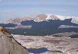
Corserine is the highest point of the Rhinns of Kells range in the Southern Uplands
of southern Scotland
. The usual route of ascent is from the car park at Forest Lodge to the east of the hill via Loch Harrow and North Gairy Top. Forest Lodge is a short drive from the village of St. John's Town of Dalry
.
Southern Uplands
The Southern Uplands are the southernmost and least populous of mainland Scotland's three major geographic areas . The term is used both to describe the geographical region and to collectively denote the various ranges of hills within this region...
of southern Scotland
Scotland
Scotland is a country that is part of the United Kingdom. Occupying the northern third of the island of Great Britain, it shares a border with England to the south and is bounded by the North Sea to the east, the Atlantic Ocean to the north and west, and the North Channel and Irish Sea to the...
. The usual route of ascent is from the car park at Forest Lodge to the east of the hill via Loch Harrow and North Gairy Top. Forest Lodge is a short drive from the village of St. John's Town of Dalry
St. John's Town of Dalry
St. John's Town of Dalry, usually referred to simply as Dalry, is a village in Dumfries and Galloway, formerly in Kirkcudbrightshire. It is located sixteen miles from Castle Douglas along the A713 road, and is at the southern terminus of the A702 road...
.