

Mount Baker Tunnel
Encyclopedia
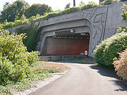
The Mount Baker Tunnel or Mount Baker Ridge Tunnel carries Interstate 90
under the Mount Baker neighborhood
of Seattle, Washington
. It is actually a group of four tunnels that carry eight lanes of freeway traffic, plus a separate tunnel for bicycles and pedestrians. The two originals are twin tunnel bores completed in 1940 and rehabilitated in 1993. Two double-decked tunnels and the bicycle/pedestrian tunnel were built north of the original tunnels in 1991.
The entire tunnel is listed on the National Register of Historic Places
(NRHP), ID #82004243. The east portals of the tunnel, along with the Lacey V. Murrow Bridge, are an official City of Seattle landmark.
The official length is 1440 feet (438.9 m), though the perceived length while driving is closer to a 1 kilometres (3,280.8 ft) because of a cut-and-cover "lid" between the western portal and the beginning of the actual tunnel under the Mount Baker ridge. The eastern end of the tunnel links to the I-90 floating bridge
on Lake Washington
.
At 63 feet (19.2 m) in diameter, it is the world's largest diameter soft earth tunnel, having been bored through clay
.
on Lake Washington
and Rainier Avenue South in Seattle. The bridge and tunnels were part of US Highway 10
, which used surface streets between the tunnels and downtown Seattle. US 10 was a four-lane, undivided highway. Each tunnel held two traffic lanes. The north tunnel normally carried two westbound lanes. The south tunnel normally carried two eastbound lanes. In the 1960s, a lane-use signal system was added to improve peak commute traffic. During peak commute times, the signals were used to make the center two lanes reversible. In the mornings, three lanes flowed west and one lane flowed east. In the evenings, three lanes flowed east and one lane flowed west. During morning and evening commutes, one tunnel carried two lanes of traffic in the same direction while the other tunnel carried opposing traffic separated by only dashed yellow lines.
The highway would later become part of Interstate 90, be expanded, and upgraded to a controlled access freeway. The freeway expansion and upgrade was completed in 1993.
 Upon completion of the I-90 expansion, the freeway capacity increased to three general purpose lanes in each direction and two reversible HOV lanes. Eastbound traffic uses the original tunnels. Westbound traffic uses the upper deck of the northern new tunnel. A two-lane reversible roadway uses the lower deck. The reversible roadway serves as express lanes for transit buses and carpools (2+ people) during peak commute periods. The express lanes flow westbound on week day mornings and eastbound on week day afternoons and evenings. On weekends, the express lanes are open; traffic direction is variable depending on anticipated traffic volumes. When the express lanes are open to eastbound traffic, single occupant vehicles headed to Mercer Island are allowed to use the lanes.
is renovating I-90 between Interstate 5
and the East Channel Bridge
to add one HOV lane in each direction. WSDOT is also modifying the Bellevue Way exit and entrance ramps. On Mercer Island, WSDOT and Sound Transit
are building direct access ramps to allow buses and HOVs to exit and enter I-90 from the future HOV lanes. When the HOV lanes and direct access ramps are complete, the express lanes will be dedicated to Eastside Link light rail use.
Sound Transit
will soon begin to build light rail rapid transit in the current I-90 Express Lanes for the East Link
light rail line connecting Seattle with the Bellevue and Redmond suburbs. Voters in urban and suburban King, Pierce, and Snohomish counties rejected the measure on November 6, 2007, as part of an $18 billion "Roads and Transit" construction package, but approved the plan a year later as part of a transit-only initiative.
Interstate 90
Interstate 90 is the longest Interstate Highway in the United States at . It is the northernmost coast-to-coast interstate, and parallels US 20 for the most part. Its western terminus is in Seattle, at Edgar Martinez Drive S. near Safeco Field and CenturyLink Field, and its eastern terminus is in...
under the Mount Baker neighborhood
Mount Baker, Seattle, Washington
Mount Baker is a neighborhood in southeast Seattle. The neighborhood's name comes from the view of Mount Baker in Whatcom County, that is seen by looking north over Lake Washington. It is bounded by Lake Washington to the east, Interstate 90 and then Leschi to the north, Rainier Valley to the west,...
of Seattle, Washington
Seattle, Washington
Seattle is the county seat of King County, Washington. With 608,660 residents as of the 2010 Census, Seattle is the largest city in the Northwestern United States. The Seattle metropolitan area of about 3.4 million inhabitants is the 15th largest metropolitan area in the country...
. It is actually a group of four tunnels that carry eight lanes of freeway traffic, plus a separate tunnel for bicycles and pedestrians. The two originals are twin tunnel bores completed in 1940 and rehabilitated in 1993. Two double-decked tunnels and the bicycle/pedestrian tunnel were built north of the original tunnels in 1991.
The entire tunnel is listed on the National Register of Historic Places
National Register of Historic Places
The National Register of Historic Places is the United States government's official list of districts, sites, buildings, structures, and objects deemed worthy of preservation...
(NRHP), ID #82004243. The east portals of the tunnel, along with the Lacey V. Murrow Bridge, are an official City of Seattle landmark.
The official length is 1440 feet (438.9 m), though the perceived length while driving is closer to a 1 kilometres (3,280.8 ft) because of a cut-and-cover "lid" between the western portal and the beginning of the actual tunnel under the Mount Baker ridge. The eastern end of the tunnel links to the I-90 floating bridge
Lacey V. Murrow Memorial Bridge
The Lacey V. Murrow Memorial Bridge is a floating bridge that carries the eastbound lanes of Interstate 90 across Lake Washington from Seattle to Mercer Island, Washington. It is the second longest floating bridge on Earth at , whereas the longest is the Evergreen Point Floating Bridge just a few...
on Lake Washington
Lake Washington
Lake Washington is a large freshwater lake adjacent to the city of Seattle. It is the largest lake in King County and the second largest in the state of Washington, after Lake Chelan. It is bordered by the cities of Seattle on the west, Bellevue and Kirkland on the east, Renton on the south and...
.
At 63 feet (19.2 m) in diameter, it is the world's largest diameter soft earth tunnel, having been bored through clay
Clay
Clay is a general term including many combinations of one or more clay minerals with traces of metal oxides and organic matter. Geologic clay deposits are mostly composed of phyllosilicate minerals containing variable amounts of water trapped in the mineral structure.- Formation :Clay minerals...
.
Original
When completed in 1940, the twin tunnels connected the I-90 floating bridgeLacey V. Murrow Memorial Bridge
The Lacey V. Murrow Memorial Bridge is a floating bridge that carries the eastbound lanes of Interstate 90 across Lake Washington from Seattle to Mercer Island, Washington. It is the second longest floating bridge on Earth at , whereas the longest is the Evergreen Point Floating Bridge just a few...
on Lake Washington
Lake Washington
Lake Washington is a large freshwater lake adjacent to the city of Seattle. It is the largest lake in King County and the second largest in the state of Washington, after Lake Chelan. It is bordered by the cities of Seattle on the west, Bellevue and Kirkland on the east, Renton on the south and...
and Rainier Avenue South in Seattle. The bridge and tunnels were part of US Highway 10
U.S. Route 10
U.S. Route 10 is an east–west United States highway formed in 1926. Though it never became the cross-country highway suggested by the "0" as the last digit of its route number, U.S...
, which used surface streets between the tunnels and downtown Seattle. US 10 was a four-lane, undivided highway. Each tunnel held two traffic lanes. The north tunnel normally carried two westbound lanes. The south tunnel normally carried two eastbound lanes. In the 1960s, a lane-use signal system was added to improve peak commute traffic. During peak commute times, the signals were used to make the center two lanes reversible. In the mornings, three lanes flowed west and one lane flowed east. In the evenings, three lanes flowed east and one lane flowed west. During morning and evening commutes, one tunnel carried two lanes of traffic in the same direction while the other tunnel carried opposing traffic separated by only dashed yellow lines.
The highway would later become part of Interstate 90, be expanded, and upgraded to a controlled access freeway. The freeway expansion and upgrade was completed in 1993.
Current
Future use
The Washington State Department of TransportationWashington State Department of Transportation
The Washington State Department of Transportation , was established in 1905. The agency, led by a Secretary and overseen by the Governor, is a Washington governmental agency that constructs, maintains, and regulates the use of the state's transportation infrastructure...
is renovating I-90 between Interstate 5
Interstate 5
Interstate 5 is the main Interstate Highway on the West Coast of the United States, running largely parallel to the Pacific Ocean coastline from Canada to Mexico . It serves some of the largest cities on the U.S...
and the East Channel Bridge
East Channel Bridge
The East Channel Bridge is a bridge carrying Interstate 90 from Mercer Island, Washington, to Bellevue, Washington, over the East Channel of Lake Washington, which separates Mercer Island from the rest of the Eastside....
to add one HOV lane in each direction. WSDOT is also modifying the Bellevue Way exit and entrance ramps. On Mercer Island, WSDOT and Sound Transit
Sound Transit
Sound Transit has been the popular name of Washington state's Central Puget Sound Regional Transit Authority since September 19, 1999. It was formed in 1996 by the Snohomish, King, and Pierce County Councils...
are building direct access ramps to allow buses and HOVs to exit and enter I-90 from the future HOV lanes. When the HOV lanes and direct access ramps are complete, the express lanes will be dedicated to Eastside Link light rail use.
Sound Transit
Sound Transit
Sound Transit has been the popular name of Washington state's Central Puget Sound Regional Transit Authority since September 19, 1999. It was formed in 1996 by the Snohomish, King, and Pierce County Councils...
will soon begin to build light rail rapid transit in the current I-90 Express Lanes for the East Link
East Link
East Link is a planned eastern extension of the Sound Transit Link Light Rail system, spanning about 22 miles from Downtown Seattle to the city of Redmond...
light rail line connecting Seattle with the Bellevue and Redmond suburbs. Voters in urban and suburban King, Pierce, and Snohomish counties rejected the measure on November 6, 2007, as part of an $18 billion "Roads and Transit" construction package, but approved the plan a year later as part of a transit-only initiative.