
Post Falls, Idaho
Encyclopedia
Post Falls is a city in Kootenai County
, Idaho
, United States
near the Idaho state line between Spokane, Washington
, and Coeur d'Alene, Idaho
. The population was 17,247 at the 2000 census, and grew to 27,574 people by the 2010 census, making it Idaho's tenth largest city.
immigrant who constructed a lumber mill along the Spokane River
in 1871 on land he purchased from Andrew Seltice, Chief of the Coeur d'Alene Tribe
. The purchase of the land is preserved in a pictograph on a granite cliff in Treaty Rock park.
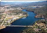
Post Falls is located four miles (6 km) east of the Washington-Idaho border along Interstate 90 in Kootenai County and is bounded by Coeur d’Alene, Idaho to the east, the State of Washington to the west, the Spokane River to the south and the Rathdrum prairie to the north. Post Falls is 20 miles (32.2 km) east of Spokane, Washington and approximately 100 miles (160.9 km) south of the Canadian border.
of 2000, there were 17,247 people, 6,369 households, and 4,668 families residing in the city. The population density
was 1,786.1 people per square mile (689.3/km²). There were 6,697 housing units at an average density of 693.5 per square mile (267.7/km²). The racial makeup of the city was 96.13% White, 0.18% African American, 0.87% Native American, 0.56% Asian, 0.06% Pacific Islander, 0.60% from other races
, and 1.61% from two or more races. Hispanic or Latino of any race were 2.55% of the population.
There were 6,369 households out of which 40.2% had children under the age of 18 living with them, 58.7% were married couples
living together, 10.1% had a female householder with no husband present, and 26.7% were non-families. 20.5% of all households were made up of individuals and 8.2% had someone living alone who was 65 years of age or older. The average household size was 2.71 and the average family size was 3.13.
In the city the population was spread out with 30.6% under the age of 18, 8.9% from 18 to 24, 31.8% from 25 to 44, 18.9% from 45 to 64, and 9.8% who were 65 years of age or older. The median age was 31 years. For every 100 females there were 95.8 males. For every 100 females age 18 and over, there were 92.4 males.
The median income for a household in the city was $39,061, and the median income for a family was $42,758. Males had a median income of $32,284 versus $22,798 for females. The per capita income
for the city was $18,692. About 7.1% of families and 9.4% of the population were below the poverty line, including 13.4% of those under age 18 and 7.5% of those age 65 or over.
As of 2009 the per capita income for the city was $32,696
Kootenai County traditionally has had a timber-based economy. That is changing gradually, as the manufacturing base has become more diverse. Jobs Plus, Inc., the local economic development organization has recruited several small to medium sized firms to the county. Manufacturing jobs are found primarily in electronics, lumber and furniture at the present. Post Falls was the chosen location for Flexcel, Inc., a major furniture manufacturer that relocated to North Idaho nearly fifteen years ago and employs a workforce of 350. This was done with the help of Jobs Plus, Inc. and by creating an Urban Renewal District to help build infrastructure. This District closed out at the end of December 2001. Jobs Plus, Inc. has also just recently helped bring Center Partners, a call center business (employing a workforce of 300), and Buck Knives
brought their manufacturing headquarters (workforce of 250) to the City. Also, Wal-Mart
opened its new store in January 2002, employing a workforce of 300.
Construction of a private surgical hospital was completed in 2004. Sysco
foods opened their distribution plant during 2005. This project was made possible by Jobs Plus, Urban Renewal, and the City working together. Also, a community development block grant for $500,000 was used to help fund a water tower (approximately $1,500,000 total cost) that was needed on the west side of town for development in that area. In 2007, Cabela’s opened its doors to a beautiful 130000 square feet (12,077.4 m²) retail store. Considerable economic development activity transpired in Post Falls in 2009 including the opening of ALK Source Materials/Biopol which is a Danish pharmaceutical company, a second Super Wal-Mart store that will be located near the new Cabelas store began its construction and is slated to open in early summer 2010, and Lowe’s Home Improvement finalized the purchase of land adjacent to the new Wal-Mart at the Pointe at Post Falls. Ground Force Manufacturing, a large construction equipment manufacturer, completed an addition that increased their production space by 20000 square feet (1,858.1 m²) in 2009 in order to meet the heavy demands for their mining construction products around the globe. In 2010, additional commercial real estate activity is anticipated including the construction of the Lowe’s Home Improvement store mentioned earlier; a new 30,000 professional office building to house a high tech network-based solutions company named Ednetics; a 30,000 LEED certified industrial building to be the home of a subsidiary of Berg Integrated Systems will begin construction in early 2010; the State of Idaho Department of Labor will construct their new regional office here in Post Falls that will provide services to the northern five counties of Idaho; Love's travel Centers will be constructing a new fuel center along Interstate 90 that will have a convenience store and new Carl’s Jr. restaurant; Blue Dog RV is planning on constructing a new recreational vehicle showroom and maintenance facility; several restaurants are also anticipated to locate within the Pointe at Post Falls regional power center to take advantage of the retail traffic of Cabela’s and Wal-Mart; the City’s downtown area is expected to see a major mixed use project also take off with infrastructure and the first phase including a hospitality component begin construction; and finally the community anticipates that construction on the Beck Road Interchange with Interstate 90 will begin this fall ultimately providing service to the Pointe at Post Falls and EXPO on the north side of the freeway and the Riverbend Commerce Park and Greyhound Event Center on the south side of the Interstate 90.
. Post Falls is approximately 7 miles (11.3 km) west of State Highway 95 which extends the length of Idaho to Canada.
Amtrak passenger service is available in Spokane, Washington and Sandpoint, Idaho
. Bus service and taxi service are available within the immediate area. Air passenger service is available with Spokane International Airport
.
Kindercenter
Mullan Trail Elementary
Ponderosa Elementary
Prairie View Elementary
Seltice Elementary
West Side Elementary
West Ridge Elementary
Post Falls Middle School
Immaculate Conception Academy
River City Middle School
Post Falls High School
New Visions Alternative High School
Riverbend Professional Technical Academy
Calvary Chapel Bible College Northwest
North Idaho College
Workforce Training Center
St. Dominic School
Kootenai County, Idaho
Kootenai County is a county located in the U.S. state of Idaho. The county was established in 1864, named after Kootenai tribe. The entire county comprises the Coeur d'Alene, Idaho Metropolitan Statistical Area. The population was 138,494 at the 2010 census...
, Idaho
Idaho
Idaho is a state in the Rocky Mountain area of the United States. The state's largest city and capital is Boise. Residents are called "Idahoans". Idaho was admitted to the Union on July 3, 1890, as the 43rd state....
, United States
United States
The United States of America is a federal constitutional republic comprising fifty states and a federal district...
near the Idaho state line between Spokane, Washington
Spokane, Washington
Spokane is a city located in the Northwestern United States in the state of Washington. It is the largest city of Spokane County of which it is also the county seat, and the metropolitan center of the Inland Northwest region...
, and Coeur d'Alene, Idaho
Coeur d'Alene, Idaho
Coeur d'Alene is the largest city and county seat of Kootenai County, Idaho, United States. It is the principal city of the Coeur d'Alene Metropolitan Statistical Area. Coeur d'Alene has the second largest metropolitan area in the state of Idaho. As of the 2010 census the population of Coeur...
. The population was 17,247 at the 2000 census, and grew to 27,574 people by the 2010 census, making it Idaho's tenth largest city.
History
Post Falls is named for Frederick Post, a GermanGermans
The Germans are a Germanic ethnic group native to Central Europe. The English term Germans has referred to the German-speaking population of the Holy Roman Empire since the Late Middle Ages....
immigrant who constructed a lumber mill along the Spokane River
Spokane River
The Spokane River is a tributary of the Columbia River, approximately long, in northern Idaho and eastern Washington in the United States. It drains a low mountainous area east of the Columbia, passing through the city of Spokane, Washington.-Description:...
in 1871 on land he purchased from Andrew Seltice, Chief of the Coeur d'Alene Tribe
Coeur d'Alene Tribe
The Coeur d'Alene are a Native American people who lived in villages along the Coeur d'Alene, St. Joe, Clark Fork and Spokane Rivers; as well as sites on the shores of Lake Coeur d'Alene, Lake Pend Oreille and Hayden Lake, in what is now northern Idaho, eastern Washington and western Montana.In...
. The purchase of the land is preserved in a pictograph on a granite cliff in Treaty Rock park.
Geography
47°42′56"N 116°56′17"W (47.715552, -116.937926).Post Falls is located four miles (6 km) east of the Washington-Idaho border along Interstate 90 in Kootenai County and is bounded by Coeur d’Alene, Idaho to the east, the State of Washington to the west, the Spokane River to the south and the Rathdrum prairie to the north. Post Falls is 20 miles (32.2 km) east of Spokane, Washington and approximately 100 miles (160.9 km) south of the Canadian border.
Climate
Post Falls has four distinct seasons, with temperatures ranging in the 80's mid-summer and low teens during the winter. The annual average amount of sunshine ranges from about 30% in the winter, but in July and August the average rises to the 80's, as crystal clear days may linger well in fall for perfect golf and boating weather. The annual average relative humidity is 46%; average amount of rain is 29", and an average of 49" of snow.Demographics
As of the censusCensus
A census is the procedure of systematically acquiring and recording information about the members of a given population. It is a regularly occurring and official count of a particular population. The term is used mostly in connection with national population and housing censuses; other common...
of 2000, there were 17,247 people, 6,369 households, and 4,668 families residing in the city. The population density
Population density
Population density is a measurement of population per unit area or unit volume. It is frequently applied to living organisms, and particularly to humans...
was 1,786.1 people per square mile (689.3/km²). There were 6,697 housing units at an average density of 693.5 per square mile (267.7/km²). The racial makeup of the city was 96.13% White, 0.18% African American, 0.87% Native American, 0.56% Asian, 0.06% Pacific Islander, 0.60% from other races
Race (United States Census)
Race and ethnicity in the United States Census, as defined by the Federal Office of Management and Budget and the United States Census Bureau, are self-identification data items in which residents choose the race or races with which they most closely identify, and indicate whether or not they are...
, and 1.61% from two or more races. Hispanic or Latino of any race were 2.55% of the population.
There were 6,369 households out of which 40.2% had children under the age of 18 living with them, 58.7% were married couples
Marriage
Marriage is a social union or legal contract between people that creates kinship. It is an institution in which interpersonal relationships, usually intimate and sexual, are acknowledged in a variety of ways, depending on the culture or subculture in which it is found...
living together, 10.1% had a female householder with no husband present, and 26.7% were non-families. 20.5% of all households were made up of individuals and 8.2% had someone living alone who was 65 years of age or older. The average household size was 2.71 and the average family size was 3.13.
In the city the population was spread out with 30.6% under the age of 18, 8.9% from 18 to 24, 31.8% from 25 to 44, 18.9% from 45 to 64, and 9.8% who were 65 years of age or older. The median age was 31 years. For every 100 females there were 95.8 males. For every 100 females age 18 and over, there were 92.4 males.
The median income for a household in the city was $39,061, and the median income for a family was $42,758. Males had a median income of $32,284 versus $22,798 for females. The per capita income
Per capita income
Per capita income or income per person is a measure of mean income within an economic aggregate, such as a country or city. It is calculated by taking a measure of all sources of income in the aggregate and dividing it by the total population...
for the city was $18,692. About 7.1% of families and 9.4% of the population were below the poverty line, including 13.4% of those under age 18 and 7.5% of those age 65 or over.
As of 2009 the per capita income for the city was $32,696
Population history
- 2010 - 27,574
- 2009 - 26,053 - estimate
- 2007 - 25,358 - estimate
- 2000 - 17,247
- 1990 - 7,389
- 1980 - 5,736
- 1970 - 2,371
- 1960 - 1,983
- 1950 - 1,069
- 1940 - 843
- 1930 - 509
- 1920 - 576
- 1910 - 658
- 1900 - 287
- 1890 - 400
- 1790 - 0
Economy
Due to the proximity of numerous lakes, rivers and mountains, Post Falls has developed tourism and retirement communities. There is an increasing number of retail, dining and entertainment businesses locating in the City.Kootenai County traditionally has had a timber-based economy. That is changing gradually, as the manufacturing base has become more diverse. Jobs Plus, Inc., the local economic development organization has recruited several small to medium sized firms to the county. Manufacturing jobs are found primarily in electronics, lumber and furniture at the present. Post Falls was the chosen location for Flexcel, Inc., a major furniture manufacturer that relocated to North Idaho nearly fifteen years ago and employs a workforce of 350. This was done with the help of Jobs Plus, Inc. and by creating an Urban Renewal District to help build infrastructure. This District closed out at the end of December 2001. Jobs Plus, Inc. has also just recently helped bring Center Partners, a call center business (employing a workforce of 300), and Buck Knives
Buck Knives
Buck Knives is an American knife manufacturer founded in San Diego, California and now located in Post Falls, Idaho. The company has a long history through five generations of the Buck family from 1902 to the present day...
brought their manufacturing headquarters (workforce of 250) to the City. Also, Wal-Mart
Wal-Mart
Wal-Mart Stores, Inc. , branded as Walmart since 2008 and Wal-Mart before then, is an American public multinational corporation that runs chains of large discount department stores and warehouse stores. The company is the world's 18th largest public corporation, according to the Forbes Global 2000...
opened its new store in January 2002, employing a workforce of 300.
Construction of a private surgical hospital was completed in 2004. Sysco
SYSCO
Sysco Corporation is the global leader in marketing and distributing food products to restaurants, healthcare and educational facilities, hotels and inns, and other foodservice and hospitality businesses...
foods opened their distribution plant during 2005. This project was made possible by Jobs Plus, Urban Renewal, and the City working together. Also, a community development block grant for $500,000 was used to help fund a water tower (approximately $1,500,000 total cost) that was needed on the west side of town for development in that area. In 2007, Cabela’s opened its doors to a beautiful 130000 square feet (12,077.4 m²) retail store. Considerable economic development activity transpired in Post Falls in 2009 including the opening of ALK Source Materials/Biopol which is a Danish pharmaceutical company, a second Super Wal-Mart store that will be located near the new Cabelas store began its construction and is slated to open in early summer 2010, and Lowe’s Home Improvement finalized the purchase of land adjacent to the new Wal-Mart at the Pointe at Post Falls. Ground Force Manufacturing, a large construction equipment manufacturer, completed an addition that increased their production space by 20000 square feet (1,858.1 m²) in 2009 in order to meet the heavy demands for their mining construction products around the globe. In 2010, additional commercial real estate activity is anticipated including the construction of the Lowe’s Home Improvement store mentioned earlier; a new 30,000 professional office building to house a high tech network-based solutions company named Ednetics; a 30,000 LEED certified industrial building to be the home of a subsidiary of Berg Integrated Systems will begin construction in early 2010; the State of Idaho Department of Labor will construct their new regional office here in Post Falls that will provide services to the northern five counties of Idaho; Love's travel Centers will be constructing a new fuel center along Interstate 90 that will have a convenience store and new Carl’s Jr. restaurant; Blue Dog RV is planning on constructing a new recreational vehicle showroom and maintenance facility; several restaurants are also anticipated to locate within the Pointe at Post Falls regional power center to take advantage of the retail traffic of Cabela’s and Wal-Mart; the City’s downtown area is expected to see a major mixed use project also take off with infrastructure and the first phase including a hospitality component begin construction; and finally the community anticipates that construction on the Beck Road Interchange with Interstate 90 will begin this fall ultimately providing service to the Pointe at Post Falls and EXPO on the north side of the freeway and the Riverbend Commerce Park and Greyhound Event Center on the south side of the Interstate 90.
Employers
As of 2009 the major employers in Post Falls were as follows| Employer | Type of business | Employees |
|---|---|---|
| Center Partners | Customer service center | 700 |
| Post Falls School District | Education | 690 |
| Wal-Mart Stores | Retail department store/grocery | 450 |
| Kimball Furniture Group, Inc. | Manufacturer of furniture | 350 |
| The City | Government | 300 |
| Buck's Knives | Manufacturer of knives | 220 |
| Cabela's | Retail | 200 |
| Sysco | Food services distributor | 185 |
| Accurate Molded Plastics | Manufacturer of molds | 160 |
| Red Lion Templin's Hotel | Lodging | 150 |
Transportation
Post Falls is served by I-90, which extends east and west of the panhandle of Idaho through Post Falls. Post Falls is located approximately two miles west of the junction of State Highway 41, which extends approximately 8 miles (12.9 km) to Rathdrum, IdahoRathdrum, Idaho
Rathdrum is a city in Kootenai County, Idaho, United States. The population was 6,826 at the 2010 census.-Geography:Rathdrum is located at ....
. Post Falls is approximately 7 miles (11.3 km) west of State Highway 95 which extends the length of Idaho to Canada.
Amtrak passenger service is available in Spokane, Washington and Sandpoint, Idaho
Sandpoint, Idaho
Sandpoint is the largest city in, and the county seat of, Bonner County, Idaho, United States. Its population was 7,365 at the 2010 census.Sandpoint's major economic contributors include forest products and light manufacturing, tourism and recreation and government services...
. Bus service and taxi service are available within the immediate area. Air passenger service is available with Spokane International Airport
Spokane International Airport
Spokane International Airport is a commercial airport located about west of downtown Spokane in Spokane County, Washington. It is the primary airport for Spokane, eastern Washington, Coeur d'Alene, and northern Idaho...
.
Education
Schools within Post Falls include:Kindercenter
Mullan Trail Elementary
Elementary school
An elementary school or primary school is an institution where children receive the first stage of compulsory education known as elementary or primary education. Elementary school is the preferred term in some countries, particularly those in North America, where the terms grade school and grammar...
Ponderosa Elementary
Prairie View Elementary
Seltice Elementary
West Side Elementary
West Ridge Elementary
Post Falls Middle School
Middle school
Middle School and Junior High School are levels of schooling between elementary and high schools. Most school systems use one term or the other, not both. The terms are not interchangeable...
Immaculate Conception Academy
River City Middle School
Post Falls High School
High school
High school is a term used in parts of the English speaking world to describe institutions which provide all or part of secondary education. The term is often incorporated into the name of such institutions....
New Visions Alternative High School
Riverbend Professional Technical Academy
Calvary Chapel Bible College Northwest
North Idaho College
North Idaho College
North Idaho College is a community college with over 6,000 students in Coeur d'Alene, Idaho, situated at the north end of Lake Coeur d'Alene.-History:The school was established during the Great Depression in 1933 as Coeur d'Alene Junior College...
Workforce Training Center
St. Dominic School