

U.S. Route 12 in Washington
Encyclopedia
U.S. Route 12 is a major east-west U.S. Highway, running from Aberdeen, Washington
, to Detroit, Michigan
. It spans 403.8 miles (649.9 km) across the state of Washington, and is the only numbered highway to span the entire state from west to east, starting near the Pacific Ocean
, and crossing the Idaho
state line near Clarkston
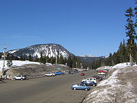
. It crosses the Cascade Range
over White Pass
, south of Mount Rainier National Park
. Portions of it are concurrent
with Interstate 5
(I-5) and Interstate 82
(I-82), although the majority of the route does not parallel any Interstate Highway.
Although US 12 was not extended into Washington until 1967, portions of it have been part of Washington's state highway system
since as early as 1905. The last part of the highway to open was over White Pass in 1951, although it was added to the state highway system by the legislature in 1931. Most of the route (except for the approximately 160 miles (257.5 km) between Elma
and Naches
) had been part of the U.S. Highway System since its inception in 1926 as part of U.S. Route 410
. The portion between Napavine
and Grand Mound
was also designated a U.S. Highway in 1926 as part of U.S. Route 99
.
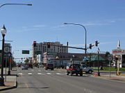 U.S. Route 12 begins in Aberdeen
on a pair of one-way streets, Heron Street eastbound and Wishkah Street westbound. At its western terminus, US 12 intersects US 101
, which goes west along Heron and Wishkah, and south across Grays Harbor to the south side of Aberdeen. The eastbound and westbound lanes of US 12 merge just east of the Wishkah River
, near the Grays Harbor Historic Seaport. US 12 then leaves Aberdeen to the east along the Chehalis River, where it passes through the towns of Central Park
and Montesano
. Between Aberdeen and Elma
, US 12 is four lanes wide. The majority of the highway in Washington, however, is a rural two-lane road.
In the town of Elma
, US 12 exits the highway at a diamond interchange
. From there, the main highway continues east to Olympia
as State Route 8
(SR 8), and US 12 heads southeast towards Oakville
and Rochester
. East of Oakville, US 12 runs north of the Chehalis Indian Reservation. It then continues east through the town of Rochester, and interchanges with I-5
at exit 88 in the town of Grand Mound
.
 US 12 continues south concurrent with I-5 through Chehalis
and Centralia
before exiting again at exit 68 south of Napavine
. The highway then heads east along the Cowlitz River
and passes through the town of Mossyrock
, where it intersects SR 122. East of Mossyrock, US 12 runs just north of Mossyrock Dam
and Riffe Lake
. In the town of Morton
, it intersects SR 7
, which heads north to Tacoma. It then ascends the Cascade Range
, passing south of Mount Rainier
, and intersects SR 123, which serves the Stevens Canyon entrance of Mount Rainier National Park
. Twelve miles (19 km) east of this intersection, US 12 crosses the Cascades over White Pass
at an elevation of 4500 feet (1,371.6 m). White Pass is the only crossing of the Cascades open year-round between I-90 over Snoqualmie Pass
and SR 14 through the Columbia River Gorge
.
After it descends the mountains, US 12 intersects SR 410
(formerly US 410) west of Naches
, which serves Chinook Pass
, Cayuse Pass
, and the White River entrance of Mount Rainier National Park. East of Naches, US 12 widens once again to four lanes as it approaches the city of Yakima
. There, it has an interchange with I-82 and US 97
at exit 31. US 12 then runs concurrently with I-82, bypassing the towns of Toppenish
and Prosser
and paralleling the Yakima River
, until exit 102 near the Tri-Cities
. At exit 102, it meets the western terminus of Interstate 182
. US 12 and I-182 then run concurrently east through the Tri-Cites. In Pasco
, I-182 ends, and US 12 intersects US 395
.
US 12 then heads south to the town of Wallula
, intersecting US 730
, then east to Walla Walla
, north to Dodge, and east to Clarkston
before crossing the Idaho
state line over the Snake River
just outside of Lewiston
. US 12 through Walla Walla consists of a four-lane bypass, also known as Inland Empire Highway. The alignment of US 12 through Walla Walla County passes by a number of historical landmarks, such as Whitman Mission and Fort Walla Walla
.
 The Washington State Legislature
created the State Highway Board in 1905 and appropriated funds to construct – but not maintain – twelve highways in sparsely settled areas of the state. Main highways in more populated areas would continue to be entirely under county control, though sometimes built with 50% state aid. Six of these highways were east-west crossings of the Cascades, including one in the corridor currently served by U.S. Route 12 – State Road 5, the Cowlitz Pass State Road, climbing east from a point near Salkum
via the Cowlitz River
, over Cowlitz Pass, and down towards Yakima. A 1907 amendment renamed State Road 5 the Cowlitz-Natches Road, moved the Cascade crossing north to Carlton Pass, and defined the portion east of the pass to follow the Bumping River
and Naches River
to a point near Naches. East of the mouth of the American River
, this replaced part of State Road 1 (North Yakima and Natches State Road), which had been defined in 1897 to cross the Cascades north of Chinook Pass
and included in the 1905 appropriations.
Under a 1909 law, the State Highway Board surveyed a connected network of proposed state roads. Included was a westerly extension of SR 5 via Chehalis to South Bend and Aberdeen and an easterly extension to Pullman. A route from Yakima southeast and east via the Tri-Cities to Idaho
was also surveyed, mostly as an extension of State Road 8 (Columbia River Road). The legislature added most of these routes to the state highway system in 1913, when they formed a two-tiered system of primary and secondary roads. Primary roads were completely controlled by the state, including maintenance, and received only names, while secondary roads kept their numbers and county maintenance. The National Park Highway replaced State Road 5 west of Riffe, and extended as surveyed to and beyond South Bend, and the McClellan Pass Highway replaced State Road 1 and continued via State Road 5 to Yakima. The majority of the route from Yakima via Connell to Pullman was not added at that time; it was finally taken over in 1937 as Secondary State Highways 11A and 11B. Only the route via the Tri-Cities, forming part of the Inland Empire Highway, continued from Yakima to Idaho. East of Pomeroy, the original survey had curved south, using State Road 16 to near the Oregon
state line; this was bypassed by the 1913 designation, which instead continued directly east to Clarkston. Unlike the earlier state roads, these primary roads mostly followed existing passable county roads. The incomplete roadway between Riffe and the American River remained as part of secondary State Road 5, and the legislature designated the surveyed route from the National Park Highway near Raymond north to Aberdeen as secondary State Road 20 in 1915.
 A 1923 restructuring of the system re-assigned numbers to almost all the primary state highways. State Road 5 became a primary route and was greatly expanded, taking over the entire McClellan Pass Highway and the National Park Highway east of the Pacific Highway. The former secondary State Road 5 was realigned starting from near Packwood, heading north instead of east, alongside the Ohanapecosh River
to the old McClellan Pass Highway at Cayuse Pass
, west of the summit of the Cascades. The new State Road 5, named the National Park Highway System, now included four roads in the vicinity of Mount Rainier National Park
, but as the road across the Cascades at Chinook Pass
was not yet built, these roads did not connect with each other. Also included in this numbering was the designation of the Inland Empire Highway, including Yakima to Clarkston, as State Road 3. In 1925, a spur was added to State Road 9 – the Olympic Highway, looping around the Olympic Peninsula
– connecting Elma to the Pacific Highway at Grand Mound, and creating a shortcut between the Cowlitz River route and Aberdeen. The Olympic Highway from Elma west to Aberdeen had been added to the state highway system in 1905 west of and 1913 east of Montesano.
As part of the U.S. Highway system laid out in 1925 and finalized in late 1926, U.S. Route 410
connected Aberdeen with Clarkston, following the Olympic Highway (State Road 9) to Olympia, the Pacific Highway (State Road 1) – concurrent with US 99 – to Tacoma, the National Park Highway System (State Road 5) to Yakima, and the Inland Empire Highway (State Road 3) to Clarkston. This differed from present US 12 between Elma and Naches in that it followed the route through Olympia and Tacoma rather than along the Cowlitz River. However, despite being part of the state highway system since 1897, US 410's crossing of the Cascades, the first between the Columbia River Gorge
and Snoqualmie Pass
, was not opened to traffic until 1931. A shortcut from near Packwood east across White Pass
to Naches, very close to the original plan for the east half of State Road 5, was added to the state highway system in 1931 as another branch of the highway. The roadway between Packwood and Cayuse Pass, added to the state highway system on a different alignment in 1905, was finally completed in 1940, and the White Pass Highway was dedicated on August 12, 1951, opening a shortcut between southwest Washington and Yakima.
 When the U.S. Highways were first established in 1926, US 12 ended in Miles City, Montana
, and most of US 12's current routing in Washington was followed by US 410
. U.S. Route 12 was extended westward in stages; an extension to Lewiston, Idaho
, was approved on June 19, 1962. At various times in the early 1960s, the states of Idaho, Washington, and Oregon submitted plans for further westward extension to the American Association of State Highway Officials (AASHO) to either Vancouver, Washington
or Boardman, Oregon
– or, a plan submitted in 1963 had the highway going only as far as Pasco – but all of these plans were rejected. Washington introduced a new system of sign route numbers
in 1964. While US 410 was still signed as such, present US 12 became State Route 8 between US 410 at Elma and US 99/I-5 at Grand Mound and State Route 14 between US 99/I-5 at Chehalis and US 410 at Naches. The extension of US 12 to Aberdeen was finally approved on June 20, 1967, with US 12 taking over much of US 410's former routing. However, where US 410 had crossed the Cascades at Chinook Pass, US 12 used the all-weather White Pass, replacing SR 8 and SR 14. Signs were changed in late December 1967, and the bypassed segments of US 410 became a new SR 8
between Elma and Olympia, and SR 410
between Tacoma
and Naches
.
Aberdeen, Washington
Aberdeen is a city in Grays Harbor County, Washington, United States, founded by Samuel Benn in 1884. Aberdeen was incorporated on May 12, 1890. The city is the economic center of Grays Harbor County, bordering the cities of Hoquiam and Cosmopolis...
, to Detroit, Michigan
Detroit, Michigan
Detroit is the major city among the primary cultural, financial, and transportation centers in the Metro Detroit area, a region of 5.2 million people. As the seat of Wayne County, the city of Detroit is the largest city in the U.S. state of Michigan and serves as a major port on the Detroit River...
. It spans 403.8 miles (649.9 km) across the state of Washington, and is the only numbered highway to span the entire state from west to east, starting near the Pacific Ocean
Pacific Ocean
The Pacific Ocean is the largest of the Earth's oceanic divisions. It extends from the Arctic in the north to the Southern Ocean in the south, bounded by Asia and Australia in the west, and the Americas in the east.At 165.2 million square kilometres in area, this largest division of the World...
, and crossing the Idaho
Idaho
Idaho is a state in the Rocky Mountain area of the United States. The state's largest city and capital is Boise. Residents are called "Idahoans". Idaho was admitted to the Union on July 3, 1890, as the 43rd state....
state line near Clarkston
Clarkston, Washington
Clarkston is a city in Asotin County in the southeastern part of the U.S. state of Washington. It is part of the Lewiston ID-WA Metropolitan Statistical Area. The population was 7,229 in 2010....
. It crosses the Cascade Range
Cascade Range
The Cascade Range is a major mountain range of western North America, extending from southern British Columbia through Washington and Oregon to Northern California. It includes both non-volcanic mountains, such as the North Cascades, and the notable volcanoes known as the High Cascades...
over White Pass
White Pass (Washington)
White Pass is a mountain pass in the Cascade Range south of Mount Rainier and north of Goat Rocks in Washington, USA. U.S. Highway 12 passes over White Pass, connecting Yakima County with Lewis County....
, south of Mount Rainier National Park
Mount Rainier National Park
Mount Rainier National Park is a United States National Park located in southeast Pierce County and northeast Lewis County in Washington state. It was one of the US's earliest National Parks, having been established on March 2, 1899 as the fifth national park in the United States. The park contains...
. Portions of it are concurrent
Concurrency (road)
A concurrency, overlap, or coincidence in a road network is an instance of one physical road bearing two or more different highway, motorway, or other route numbers...
with Interstate 5
Interstate 5 in Washington
Interstate 5 in Washington is a highway in the U.S. state of Washington that extends from its border with Oregon to its border with Canada...
(I-5) and Interstate 82
Interstate 82
Interstate 82 is a Interstate Highway that extends from I-90 in Ellensburg, Washington to I-84 near Umatilla, Oregon in the United States. In the state of Washington, it serves the cities of Ellensburg, Yakima, and the Tri Cities , and in Oregon, it serves Umatilla and Hermiston...
(I-82), although the majority of the route does not parallel any Interstate Highway.
Although US 12 was not extended into Washington until 1967, portions of it have been part of Washington's state highway system
State highways in Washington
In the U.S. state of Washington, the Washington State Department of Transportation maintains a network of over 7000 miles of state highways, including all Interstate and U.S. Highways that pass through the state. The system comprises 8.5% of the state's public road mileage, but carries over half...
since as early as 1905. The last part of the highway to open was over White Pass in 1951, although it was added to the state highway system by the legislature in 1931. Most of the route (except for the approximately 160 miles (257.5 km) between Elma
Elma, Washington
Elma is a city in Grays Harbor County, Washington, United States. The population was 3,107 at the 2010 census.-Geography:Elma is located at ....
and Naches
Naches, Washington
Naches is a town in Yakima County, Washington, United States. The population was 795 individuals at the 2010 census.-Infrastructure:Naches' infrastructure is based mainly on timber and agriculture, known for its large masses of apple, cherries, pears and various other fruits.-Geography:Naches is...
) had been part of the U.S. Highway System since its inception in 1926 as part of U.S. Route 410
U.S. Route 410
U.S. Route 410 was one of the west–east state highways. It ran from an intersection with US 101 in Aberdeen, Washington to US 95 in Lewiston, Idaho. The route had concurrencies with SR 8, US 99, and US 395. Even though the number indicates that US 410 was a spur of U.S. Route 10, US 410 never...
. The portion between Napavine
Napavine, Washington
Napavine is a city in Lewis County, Washington, United States. The population was 1,766 at the 2010 census.-History:Napavine was officially incorporated as a town on November 21, 1913. Settlers began arriving in the Cowlitz area in the early 1850s...
and Grand Mound
Grand Mound, Washington
Grand Mound is a census-designated place in Thurston County, Washington, United States. It was named and founded by Jotham Weeks Judson, father of Phoebe Judson, in 1851. The population was 1,948 at the 2000 census. In 2007, the population was 2,232...
was also designated a U.S. Highway in 1926 as part of U.S. Route 99
U.S. Route 99
U.S. Route 99 was the main north–south highway on the West Coast of the United States until 1964, running from Calexico, California, on the U.S.-Mexico border to Blaine, Washington, on the U.S.-Canada border. It was a route of the United States Numbered Highways, assigned in 1926 and existing...
.
Route description
Aberdeen, Washington
Aberdeen is a city in Grays Harbor County, Washington, United States, founded by Samuel Benn in 1884. Aberdeen was incorporated on May 12, 1890. The city is the economic center of Grays Harbor County, bordering the cities of Hoquiam and Cosmopolis...
on a pair of one-way streets, Heron Street eastbound and Wishkah Street westbound. At its western terminus, US 12 intersects US 101
U.S. Route 101 in Washington
In the U.S. state of Washington, U.S. Route 101 is the westernmost state highway, serving the Olympic Peninsula. It runs from the Astoria-Megler Bridge north to the cities of Raymond, Aberdeen, Hoquiam, and Forks before turning east at the small community of Beaver to the most northern point of the...
, which goes west along Heron and Wishkah, and south across Grays Harbor to the south side of Aberdeen. The eastbound and westbound lanes of US 12 merge just east of the Wishkah River
Wishkah River
The Wishkah River is a tributary of the Chehalis River, approximately long, in the U.S. state of Washington. The river drains a remote rural area of approximately in Grays Harbor County along the Washington coast north of Aberdeen...
, near the Grays Harbor Historic Seaport. US 12 then leaves Aberdeen to the east along the Chehalis River, where it passes through the towns of Central Park
Central Park, Washington
Central Park is a census-designated place in Grays Harbor County, Washington, United States. The population was 2,685 at the 2010 census.-Geography:Central Park is located at ....
and Montesano
Montesano, Washington
Montesano is a city in Grays Harbor County, Washington, United States. The population was 3,976 at the 2010 census. It is the county seat of Grays Harbor County.-History:Montesano was first settled in 1852 by Isaiah L. Scammon....
. Between Aberdeen and Elma
Elma, Washington
Elma is a city in Grays Harbor County, Washington, United States. The population was 3,107 at the 2010 census.-Geography:Elma is located at ....
, US 12 is four lanes wide. The majority of the highway in Washington, however, is a rural two-lane road.
In the town of Elma
Elma, Washington
Elma is a city in Grays Harbor County, Washington, United States. The population was 3,107 at the 2010 census.-Geography:Elma is located at ....
, US 12 exits the highway at a diamond interchange
Diamond interchange
A diamond interchange is a common type of road junction, used where a freeway crosses a minor road. The freeway itself is grade-separated from the minor road, one crossing the other over a bridge...
. From there, the main highway continues east to Olympia
Olympia, Washington
Olympia is the capital city of the U.S. state of Washington and the county seat of Thurston County. It was incorporated on January 28, 1859. The population was 46,478 at the 2010 census...
as State Route 8
State Route 8 (Washington)
State Route 8 is a state highway in Grays Harbor and Thurston counties, of the U.S. state of Washington. It extends from U.S. Route 12 in the city of Elma, east to an interchange with US 101 about northwest of the state capital, Olympia. SR 8 intersects SR 108 west of McCleary...
(SR 8), and US 12 heads southeast towards Oakville
Oakville, Washington
Oakville is a city in Grays Harbor County, Washington, United States. The population was 684 at the 2010 census.-Geography:Oakville is located at ....
and Rochester
Rochester, Washington
Rochester is a census-designated place in Thurston County, Washington, United States. It was founded in 1852, and the 2000 census recorded its population at 1,829. According to the United States Census Bureau, the CDP has a total area of 2.3 square miles , all of it land. Rochester Schools...
. East of Oakville, US 12 runs north of the Chehalis Indian Reservation. It then continues east through the town of Rochester, and interchanges with I-5
Interstate 5
Interstate 5 is the main Interstate Highway on the West Coast of the United States, running largely parallel to the Pacific Ocean coastline from Canada to Mexico . It serves some of the largest cities on the U.S...
at exit 88 in the town of Grand Mound
Grand Mound, Washington
Grand Mound is a census-designated place in Thurston County, Washington, United States. It was named and founded by Jotham Weeks Judson, father of Phoebe Judson, in 1851. The population was 1,948 at the 2000 census. In 2007, the population was 2,232...
.
Chehalis, Washington
Chehalis is a city in Lewis County, Washington, United States. The population was 7,259 at the 2010 census. It is the county seat of Lewis County.-History:...
and Centralia
Centralia, Washington
Centralia is a city in Lewis County, Washington, United States. The population was 16,336 at the 2010 census.-History:In pioneer days, Centralia was the halfway stopover point for stagecoaches operating between the Columbia River and Seattle. In 1850, J. G. Cochran came from Missouri with his...
before exiting again at exit 68 south of Napavine
Napavine, Washington
Napavine is a city in Lewis County, Washington, United States. The population was 1,766 at the 2010 census.-History:Napavine was officially incorporated as a town on November 21, 1913. Settlers began arriving in the Cowlitz area in the early 1850s...
. The highway then heads east along the Cowlitz River
Cowlitz River
The Cowlitz River is a river in the state of Washington in the United States, a tributary of the Columbia River. Its tributaries drain a large region including the slopes of Mount Rainier, Mount Adams, and Mount St. Helens....
and passes through the town of Mossyrock
Mossyrock, Washington
Mossyrock is a city in Lewis County, Washington, United States. The population was 759 at the 2010 census.-History:The city began as a trading post named Mossy Rock in 1852, after a high moss-covered rock at the east end of Klickitat Prairie...
, where it intersects SR 122. East of Mossyrock, US 12 runs just north of Mossyrock Dam
Mossyrock Dam
Mossyrock Dam is a concrete arch-gravity dam on the Cowlitz River near Mossyrock in Lewis County, Washington. The reservoir created by the dam is called Riffe Lake and the primary purpose of the dam is hydroelectric production while flood control is secondary...
and Riffe Lake
Riffe Lake
Riffe Lake is a long reservoir on the Cowlitz River in the U.S. state of Washington. Originally named Davisson Lake, it was created in 1968 with the construction of Mossyrock Dam. The lake was renamed in 1976 after the community of Riffe, which was inundated by the lake....
. In the town of Morton
Morton, Washington
Morton is a city in Lewis County, Washington, United States. The population was 1,126 at the 2010 census.-History:Morton was first settled in 1871 by James Fletcher. It was later named after Benjamin Harrison's Vice President, Levi P. Morton, in 1889. Morton was officially incorporated on January...
, it intersects SR 7
State Route 7 (Washington)
State Route 7 is a state highway in Lewis and Pierce counties, located in the U.S. state of Washington. The long roadway begins at in Morton and continues north to intersect several other state highways to Tacoma, where it ends at an interchange with and...
, which heads north to Tacoma. It then ascends the Cascade Range
Cascade Range
The Cascade Range is a major mountain range of western North America, extending from southern British Columbia through Washington and Oregon to Northern California. It includes both non-volcanic mountains, such as the North Cascades, and the notable volcanoes known as the High Cascades...
, passing south of Mount Rainier
Mount Rainier
Mount Rainier is a massive stratovolcano located southeast of Seattle in the state of Washington, United States. It is the most topographically prominent mountain in the contiguous United States and the Cascade Volcanic Arc, with a summit elevation of . Mt. Rainier is considered one of the most...
, and intersects SR 123, which serves the Stevens Canyon entrance of Mount Rainier National Park
Mount Rainier National Park
Mount Rainier National Park is a United States National Park located in southeast Pierce County and northeast Lewis County in Washington state. It was one of the US's earliest National Parks, having been established on March 2, 1899 as the fifth national park in the United States. The park contains...
. Twelve miles (19 km) east of this intersection, US 12 crosses the Cascades over White Pass
White Pass (Washington)
White Pass is a mountain pass in the Cascade Range south of Mount Rainier and north of Goat Rocks in Washington, USA. U.S. Highway 12 passes over White Pass, connecting Yakima County with Lewis County....
at an elevation of 4500 feet (1,371.6 m). White Pass is the only crossing of the Cascades open year-round between I-90 over Snoqualmie Pass
Snoqualmie Pass
Snoqualmie Pass is a mountain pass that carries Interstate 90 through the Cascade Range in the U.S. State of Washington. The elevation of the pass summit is , and is on the county line between Kittitas County and King County...
and SR 14 through the Columbia River Gorge
Columbia River Gorge
The Columbia River Gorge is a canyon of the Columbia River in the Pacific Northwest of the United States. Up to deep, the canyon stretches for over as the river winds westward through the Cascade Range forming the boundary between the State of Washington to the north and Oregon to the south...
.
After it descends the mountains, US 12 intersects SR 410
State Route 410 (Washington)
State Route 410 is a long state highway that traverses Pierce, King, and Yakima counties in the U.S. state of Washington. It begins at an interchange with SR 167 in Sumner and travels southeast across the Cascade Range to a junction with U.S. Route 12 in Naches...
(formerly US 410) west of Naches
Naches, Washington
Naches is a town in Yakima County, Washington, United States. The population was 795 individuals at the 2010 census.-Infrastructure:Naches' infrastructure is based mainly on timber and agriculture, known for its large masses of apple, cherries, pears and various other fruits.-Geography:Naches is...
, which serves Chinook Pass
Chinook Pass
Chinook Pass is a pass through the Cascade Range in the state of Washington.The pass provides the east entrance to Mount Rainier National Park, and carries State Route 410 between the towns of Enumclaw and Naches. Because of the high elevation, Chinook Pass is usually closed in November due to...
, Cayuse Pass
Cayuse Pass
Cayuse Pass is a mountain pass in the Cascade Mountains in the state of Washington.The pass is about 32 miles southeast of Enumclaw on State Route 410. The intersection with State Route 123 is at the pass....
, and the White River entrance of Mount Rainier National Park. East of Naches, US 12 widens once again to four lanes as it approaches the city of Yakima
Yakima, Washington
Yakima is an American city southeast of Mount Rainier National Park and the county seat of Yakima County, Washington, United States, and the eighth largest city by population in the state itself. As of the 2010 census, the city had a total population of 91,196 and a metropolitan population of...
. There, it has an interchange with I-82 and US 97
U.S. Route 97 in Washington
In the U.S. state of Washington, U.S. Route 97 is a route which traverses from the Oregon state line at the northern end of the Sam Hill Memorial Bridge in Maryhill, north to the Canadian border in Okanogan County near Oroville...
at exit 31. US 12 then runs concurrently with I-82, bypassing the towns of Toppenish
Toppenish, Washington
Toppenish is a city in Yakima County, Washington, in the United States. As of the 2010 census, the city population was 8,949.-History:The General Allotment Act of 1887 granted an allotment of land to a woman of half Indian ancestry, Josephine Bowser Lillie, known as "The Mother of Toppenish"...
and Prosser
Prosser, Washington
Prosser is a city in and the county seat of Benton County, Washington, United States, along the Yakima River with only one zip code 99350. The population was 5,714 at the 2010 census.-History:...
and paralleling the Yakima River
Yakima River
The Yakima River is a tributary of the Columbia River in south central and eastern Washington State, named for the indigenous Yakama people. The length of the river from headwaters to mouth is , with an average drop of .-Course:...
, until exit 102 near the Tri-Cities
Tri-Cities, Washington
The Tri-Cities is a mid-sized metropolitan area in the southeastern part of the U.S. state of Washington, consisting of three neighboring cities: Kennewick, Pasco, and Richland. The cities are located at the confluence of the Yakima, Snake, and Columbia rivers in the semi-arid region of...
. At exit 102, it meets the western terminus of Interstate 182
Interstate 182
Interstate 182 is a Interstate Highway that extends from I-82 west of Richland to US 12 in Pasco. It serves the Tri-Cities. The whole length of I-182 is concurrent with US 12, which extends westwards to Yakima, Naches, and Aberdeen and extends eastwards to Walla Walla, Lewiston, Idaho,...
. US 12 and I-182 then run concurrently east through the Tri-Cites. In Pasco
Pasco, Washington
Pasco is a city in and the county seat of Franklin County, Washington, United States.Pasco is one of three cities that make up the Tri-Cities region of the state of Washington...
, I-182 ends, and US 12 intersects US 395
U.S. Route 395 in Washington
In the U.S. state of Washington, U.S. Route 395 is a major state highway in two parts, separated by a long overlap with Interstate 90 between Ritzville and Spokane. The southern piece, from I-82 near the Tri-Cities to I-90 near Ritzville, is a high-speed four-lane divided highway...
.
US 12 then heads south to the town of Wallula
Wallula, Washington
Wallula is a census-designated place in Walla Walla County, Washington, United States. The population was 179 at the 2010 census.-History:Lewis and Clark reached the area April 27, 1806, on their return journey from the Pacific...
, intersecting US 730
U.S. Route 730
U.S. Route 730 is a U.S. highway in the U.S. states of Oregon and Washington. It is numbered as a spur of U.S. Route 30, which runs from Astoria, Oregon to Atlantic City, New Jersey. US 730 stretches 42 miles from Interstate 84 and U.S. Route 30 east of Boardman, Oregon northeast to U.S. Route 12...
, then east to Walla Walla
Walla Walla, Washington
Walla Walla is the largest city in and the county seat of Walla Walla County, Washington, United States. The population was 31,731 at the 2010 census...
, north to Dodge, and east to Clarkston
Clarkston, Washington
Clarkston is a city in Asotin County in the southeastern part of the U.S. state of Washington. It is part of the Lewiston ID-WA Metropolitan Statistical Area. The population was 7,229 in 2010....
before crossing the Idaho
Idaho
Idaho is a state in the Rocky Mountain area of the United States. The state's largest city and capital is Boise. Residents are called "Idahoans". Idaho was admitted to the Union on July 3, 1890, as the 43rd state....
state line over the Snake River
Snake River
The Snake is a major river of the greater Pacific Northwest in the United States. At long, it is the largest tributary of the Columbia River, the largest North American river that empties into the Pacific Ocean...
just outside of Lewiston
Lewiston, Idaho
Lewiston is a city in and also the county seat of Nez Perce County in the Pacific Northwest state of Idaho. It is the second-largest city in the northern Idaho region, behind Coeur d'Alene and ninth-largest in the state. Lewiston is the principal city of the Lewiston, ID - Clarkston, WA...
. US 12 through Walla Walla consists of a four-lane bypass, also known as Inland Empire Highway. The alignment of US 12 through Walla Walla County passes by a number of historical landmarks, such as Whitman Mission and Fort Walla Walla
Fort Walla Walla
Fort Walla Walla is a fort located in Walla Walla, Washington. It was established in 1858. Today, the complex contains a park, a museum, and a hospital.Fort Walla Walla should be distinguished from Fort Nez Percés or Old Fort Walla Walla ....
.
History
Washington State Legislature
The Washington State Legislature is the state legislature of the U.S. state of Washington. It is a bipartisan, bicameral body, composed of the lower Washington House of Representatives, composed of 98 Representatives, and the upper Washington State Senate, with 49 Senators.The State Legislature...
created the State Highway Board in 1905 and appropriated funds to construct – but not maintain – twelve highways in sparsely settled areas of the state. Main highways in more populated areas would continue to be entirely under county control, though sometimes built with 50% state aid. Six of these highways were east-west crossings of the Cascades, including one in the corridor currently served by U.S. Route 12 – State Road 5, the Cowlitz Pass State Road, climbing east from a point near Salkum
Salkum, Washington
Salkum is a rural unincorporated town in Lewis County, Washington, United States. The town is located on U.S. Route 12 and has a library, post office, and a fire department....
via the Cowlitz River
Cowlitz River
The Cowlitz River is a river in the state of Washington in the United States, a tributary of the Columbia River. Its tributaries drain a large region including the slopes of Mount Rainier, Mount Adams, and Mount St. Helens....
, over Cowlitz Pass, and down towards Yakima. A 1907 amendment renamed State Road 5 the Cowlitz-Natches Road, moved the Cascade crossing north to Carlton Pass, and defined the portion east of the pass to follow the Bumping River
Bumping River
The Bumping River is a tributary of the Naches River, in Washington in the United States. It flows down the east side of the Cascade Range, through Wenatchee National Forest and the William O. Douglas Wilderness. From its source at Fish Lake near Crag Mountain, it flows northeast to Bumping Lake, a...
and Naches River
Naches River
The Naches River is a tributary of the Yakima River in central Washington in the United States. Beginning as the Little Naches River, it is about 75 miles long. After the confluence of the Little Naches and Bumping River the name becomes simply the Naches River...
to a point near Naches. East of the mouth of the American River
American River (Washington)
The American River is a tributary of the Bumping River, in Washington in the United States. It flows down the east side of the Cascade Range, through Wenatchee National Forest and the William O...
, this replaced part of State Road 1 (North Yakima and Natches State Road), which had been defined in 1897 to cross the Cascades north of Chinook Pass
Chinook Pass
Chinook Pass is a pass through the Cascade Range in the state of Washington.The pass provides the east entrance to Mount Rainier National Park, and carries State Route 410 between the towns of Enumclaw and Naches. Because of the high elevation, Chinook Pass is usually closed in November due to...
and included in the 1905 appropriations.
Under a 1909 law, the State Highway Board surveyed a connected network of proposed state roads. Included was a westerly extension of SR 5 via Chehalis to South Bend and Aberdeen and an easterly extension to Pullman. A route from Yakima southeast and east via the Tri-Cities to Idaho
Idaho
Idaho is a state in the Rocky Mountain area of the United States. The state's largest city and capital is Boise. Residents are called "Idahoans". Idaho was admitted to the Union on July 3, 1890, as the 43rd state....
was also surveyed, mostly as an extension of State Road 8 (Columbia River Road). The legislature added most of these routes to the state highway system in 1913, when they formed a two-tiered system of primary and secondary roads. Primary roads were completely controlled by the state, including maintenance, and received only names, while secondary roads kept their numbers and county maintenance. The National Park Highway replaced State Road 5 west of Riffe, and extended as surveyed to and beyond South Bend, and the McClellan Pass Highway replaced State Road 1 and continued via State Road 5 to Yakima. The majority of the route from Yakima via Connell to Pullman was not added at that time; it was finally taken over in 1937 as Secondary State Highways 11A and 11B. Only the route via the Tri-Cities, forming part of the Inland Empire Highway, continued from Yakima to Idaho. East of Pomeroy, the original survey had curved south, using State Road 16 to near the Oregon
Oregon
Oregon is a state in the Pacific Northwest region of the United States. It is located on the Pacific coast, with Washington to the north, California to the south, Nevada on the southeast and Idaho to the east. The Columbia and Snake rivers delineate much of Oregon's northern and eastern...
state line; this was bypassed by the 1913 designation, which instead continued directly east to Clarkston. Unlike the earlier state roads, these primary roads mostly followed existing passable county roads. The incomplete roadway between Riffe and the American River remained as part of secondary State Road 5, and the legislature designated the surveyed route from the National Park Highway near Raymond north to Aberdeen as secondary State Road 20 in 1915.
Ohanapecosh River
The Ohanapecosh River is a river in the U.S. state of Washington.It is the main headwater tributary of the Cowlitz River, which begins at the confluence of the Ohanapecosh River and the Clear Fork Cowlitz River. The Ohanapecosh originates near Ohanapecosh Glacier on the southeast side of Mount...
to the old McClellan Pass Highway at Cayuse Pass
Cayuse Pass
Cayuse Pass is a mountain pass in the Cascade Mountains in the state of Washington.The pass is about 32 miles southeast of Enumclaw on State Route 410. The intersection with State Route 123 is at the pass....
, west of the summit of the Cascades. The new State Road 5, named the National Park Highway System, now included four roads in the vicinity of Mount Rainier National Park
Mount Rainier National Park
Mount Rainier National Park is a United States National Park located in southeast Pierce County and northeast Lewis County in Washington state. It was one of the US's earliest National Parks, having been established on March 2, 1899 as the fifth national park in the United States. The park contains...
, but as the road across the Cascades at Chinook Pass
Chinook Pass
Chinook Pass is a pass through the Cascade Range in the state of Washington.The pass provides the east entrance to Mount Rainier National Park, and carries State Route 410 between the towns of Enumclaw and Naches. Because of the high elevation, Chinook Pass is usually closed in November due to...
was not yet built, these roads did not connect with each other. Also included in this numbering was the designation of the Inland Empire Highway, including Yakima to Clarkston, as State Road 3. In 1925, a spur was added to State Road 9 – the Olympic Highway, looping around the Olympic Peninsula
Olympic Peninsula
The Olympic Peninsula is the large arm of land in western Washington state of the USA, that lies across Puget Sound from Seattle. It is bounded on the west by the Pacific Ocean, the north by the Strait of Juan de Fuca, and the east by Puget Sound. Cape Alava, the westernmost point in the contiguous...
– connecting Elma to the Pacific Highway at Grand Mound, and creating a shortcut between the Cowlitz River route and Aberdeen. The Olympic Highway from Elma west to Aberdeen had been added to the state highway system in 1905 west of and 1913 east of Montesano.
As part of the U.S. Highway system laid out in 1925 and finalized in late 1926, U.S. Route 410
U.S. Route 410
U.S. Route 410 was one of the west–east state highways. It ran from an intersection with US 101 in Aberdeen, Washington to US 95 in Lewiston, Idaho. The route had concurrencies with SR 8, US 99, and US 395. Even though the number indicates that US 410 was a spur of U.S. Route 10, US 410 never...
connected Aberdeen with Clarkston, following the Olympic Highway (State Road 9) to Olympia, the Pacific Highway (State Road 1) – concurrent with US 99 – to Tacoma, the National Park Highway System (State Road 5) to Yakima, and the Inland Empire Highway (State Road 3) to Clarkston. This differed from present US 12 between Elma and Naches in that it followed the route through Olympia and Tacoma rather than along the Cowlitz River. However, despite being part of the state highway system since 1897, US 410's crossing of the Cascades, the first between the Columbia River Gorge
Columbia River Gorge
The Columbia River Gorge is a canyon of the Columbia River in the Pacific Northwest of the United States. Up to deep, the canyon stretches for over as the river winds westward through the Cascade Range forming the boundary between the State of Washington to the north and Oregon to the south...
and Snoqualmie Pass
Snoqualmie Pass
Snoqualmie Pass is a mountain pass that carries Interstate 90 through the Cascade Range in the U.S. State of Washington. The elevation of the pass summit is , and is on the county line between Kittitas County and King County...
, was not opened to traffic until 1931. A shortcut from near Packwood east across White Pass
White Pass (Washington)
White Pass is a mountain pass in the Cascade Range south of Mount Rainier and north of Goat Rocks in Washington, USA. U.S. Highway 12 passes over White Pass, connecting Yakima County with Lewis County....
to Naches, very close to the original plan for the east half of State Road 5, was added to the state highway system in 1931 as another branch of the highway. The roadway between Packwood and Cayuse Pass, added to the state highway system on a different alignment in 1905, was finally completed in 1940, and the White Pass Highway was dedicated on August 12, 1951, opening a shortcut between southwest Washington and Yakima.
Miles City, Montana
Miles City is a city in and the county seat of Custer County, Montana, United States. The population was 8,123 at the 2010 census.- History :...
, and most of US 12's current routing in Washington was followed by US 410
U.S. Route 410
U.S. Route 410 was one of the west–east state highways. It ran from an intersection with US 101 in Aberdeen, Washington to US 95 in Lewiston, Idaho. The route had concurrencies with SR 8, US 99, and US 395. Even though the number indicates that US 410 was a spur of U.S. Route 10, US 410 never...
. U.S. Route 12 was extended westward in stages; an extension to Lewiston, Idaho
Lewiston, Idaho
Lewiston is a city in and also the county seat of Nez Perce County in the Pacific Northwest state of Idaho. It is the second-largest city in the northern Idaho region, behind Coeur d'Alene and ninth-largest in the state. Lewiston is the principal city of the Lewiston, ID - Clarkston, WA...
, was approved on June 19, 1962. At various times in the early 1960s, the states of Idaho, Washington, and Oregon submitted plans for further westward extension to the American Association of State Highway Officials (AASHO) to either Vancouver, Washington
Vancouver, Washington
Vancouver is a city on the north bank of the Columbia River in the U.S. state of Washington. Incorporated in 1857, it is the fourth largest city in the state with a 2010 census population of 161,791 as of April 1, 2010...
or Boardman, Oregon
Boardman, Oregon
Boardman is a city in Morrow County, Oregon, United States on the Columbia River and Interstate 84. As of the 2010 census the population was 3,220. It is part of the Pendleton–Hermiston Micropolitan Statistical Area.-History:...
– or, a plan submitted in 1963 had the highway going only as far as Pasco – but all of these plans were rejected. Washington introduced a new system of sign route numbers
1964 state highway renumbering (Washington)
In 1963, a law was passed authorizing a new numbering for sign routes. In 1970 the legislative definitions were changed to use the sign route numbers but renamed state routes...
in 1964. While US 410 was still signed as such, present US 12 became State Route 8 between US 410 at Elma and US 99/I-5 at Grand Mound and State Route 14 between US 99/I-5 at Chehalis and US 410 at Naches. The extension of US 12 to Aberdeen was finally approved on June 20, 1967, with US 12 taking over much of US 410's former routing. However, where US 410 had crossed the Cascades at Chinook Pass, US 12 used the all-weather White Pass, replacing SR 8 and SR 14. Signs were changed in late December 1967, and the bypassed segments of US 410 became a new SR 8
State Route 8 (Washington)
State Route 8 is a state highway in Grays Harbor and Thurston counties, of the U.S. state of Washington. It extends from U.S. Route 12 in the city of Elma, east to an interchange with US 101 about northwest of the state capital, Olympia. SR 8 intersects SR 108 west of McCleary...
between Elma and Olympia, and SR 410
Washington State Route 410
State Route 410 is a long state highway that traverses Pierce, King, and Yakima counties in the U.S. state of Washington. It begins at an interchange with SR 167 in Sumner and travels southeast across the Cascade Range to a junction with U.S. Route 12 in Naches...
between Tacoma
Tacoma, Washington
Tacoma is a mid-sized urban port city and the county seat of Pierce County, Washington, United States. The city is on Washington's Puget Sound, southwest of Seattle, northeast of the state capital, Olympia, and northwest of Mount Rainier National Park. The population was 198,397, according to...
and Naches
Naches, Washington
Naches is a town in Yakima County, Washington, United States. The population was 795 individuals at the 2010 census.-Infrastructure:Naches' infrastructure is based mainly on timber and agriculture, known for its large masses of apple, cherries, pears and various other fruits.-Geography:Naches is...
.
Major intersections
| County | Location | Mile | # Exit number An exit number is a number assigned to a road junction, usually an exit from a freeway. It is usually marked on the same sign as the destinations of the exit, as well as a sign in the gore.... |
Destinations | Notes |
|---|---|---|---|---|---|
| Grays Harbor | Aberdeen | 0.00 | , Hoquiam | ||
| 9.41 | Devonshire Road | ||||
| Montesano | 10.24 | ||||
| Elma | 20.19 | 3rd Street – Satsop Development Park | Interchange | ||
| 20.99 | Interchange | ||||
| Thurston | 41.58 | Albany Street | Former SR 121 | ||
| 46.07 | Old Highway 99 – Grand Mound Grand Mound, Washington Grand Mound is a census-designated place in Thurston County, Washington, United States. It was named and founded by Jotham Weeks Judson, father of Phoebe Judson, in 1851. The population was 1,948 at the 2000 census. In 2007, the population was 2,232... |
Former US 99 south | |||
| 46.32 | Old Highway 99 – Tenino | Former US 99 north | |||
| 46.32 | 88 | West end of I-5 overlap | |||
| West end of freeway | |||||
| Lewis Lewis County, Washington Lewis County is a county located in the U.S. state of Washington. As of 2010, the population was 75,455. The county seat is at Chehalis, and its largest city is Centralia.... |
Centralia Centralia, Washington Centralia is a city in Lewis County, Washington, United States. The population was 16,336 at the 2010 census.-History:In pioneer days, Centralia was the halfway stopover point for stagecoaches operating between the Columbia River and Seattle. In 1850, J. G. Cochran came from Missouri with his... |
51.92 | 82 | Harrison Avenue, Factory Outlet Way | |
| 52.98 | 81 | ||||
| Chehalis Chehalis, Washington Chehalis is a city in Lewis County, Washington, United States. The population was 7,259 at the 2010 census. It is the county seat of Lewis County.-History:... |
55.57 | 79 | Chamber Way | ||
| 56.68 | 77 | ||||
| 58.10 | 76 | 13th Street | |||
| Napavine Napavine, Washington Napavine is a city in Lewis County, Washington, United States. The population was 1,766 at the 2010 census.-History:Napavine was officially incorporated as a town on November 21, 1913. Settlers began arriving in the Cowlitz area in the early 1850s... |
61.87 | 72 | Rush Road | ||
| 63.60 | 71 | ||||
| 66.24 | 68 | – Portland | East end of I-5 overlap | ||
| East end of freeway | |||||
| Mary's Corner | 68.86 | Jackson Highway – Lewis and Clark State Park Lewis and Clark State Park (Washington) Lewis and Clark State Park in Lewis County, Washington is a camping park in the Washington State Park System. It consists of in one of the last major stands of old-growth forest in Washington. Available activities include hiking, horse trails, interpretive activities, wildlife viewing, athletic... |
Former US 99 | ||
| Silver Creek Silver Creek, Washington Silver Creek is an unincorporated community in Lewis County, Washington, United States. Silver Creek is located along U.S. Route 12 near its junction with Washington State Route 122, west of Mossyrock. Silver Creek has a post office with ZIP code 98585.... |
79.98 | ||||
| Mossyrock Mossyrock, Washington Mossyrock is a city in Lewis County, Washington, United States. The population was 759 at the 2010 census.-History:The city began as a trading post named Mossy Rock in 1852, after a high moss-covered rock at the east end of Klickitat Prairie... |
86.59 | ||||
| Morton | 97.40 | ||||
| Randle Randle, Washington Randle is an unincorporated community in extreme eastern Lewis County, Washington, United States. Randle is located on U.S. Route 12 and is notable as the northeastern access point to the Mount St. Helens Windy Ridge viewpoint, by way of forest service roads that cut through the Gifford Pinchot... |
114.72 | ||||
| 138.34 | |||||
| 150.79 | White Pass White Pass (Washington) White Pass is a mountain pass in the Cascade Range south of Mount Rainier and north of Goat Rocks in Washington, USA. U.S. Highway 12 passes over White Pass, connecting Yakima County with Lewis County.... |
||||
| Yakima | |||||
| 185.08 | |||||
| 199.06 | West end of freeway | ||||
| Yakima | 199.64 | Fruitvale Boulevard, North 40th Avenue | |||
| 201.25 | North 16th Avenue | ||||
| 202.19 | North 1st Street | ||||
| 202.44 | 31 | West end of I-82/US 97 overlap | |||
| 204.27 | 33A | Fair Avenue, Lincoln Avenue | Eastbound exit and entrance | ||
| 204.27 | 33B | Yakima Avenue – Terrace Heights Terrace Heights, Washington Terrace Heights is a census-designated place in Yakima County, Washington, United States. The population was 6,937 at the 2010 census. It is essentially a suburb of the city of Yakima.-Geography:Terrace Heights is located at .... |
Signed as exit 33 westbound | ||
| 205.80 | 34 | ||||
| Union Gap Union Gap, Washington Union Gap is a city in Yakima County, Washington, in the United States. As of the 2010 census, the city population was 6,047.-History:The city of Union Gap was originally named Yakima and was officially incorporated on November 23, 1883... |
207.32 | 36 | Valley Mall Boulevard – Union Gap | ||
| 208.87 | 37 | , Bend Bend, Oregon Bend is a city in and the county seat of Deschutes County, Oregon, United States, and the principal city of the Bend, Oregon Metropolitan Statistical Area. Bend is Central Oregon's largest city, and, despite its modest size, is the de facto metropolis of the region, owing to the low population... |
East end of US 97 overlap; eastbound exit and westbound entrance | ||
| 209.13 | 38 | Union Gap | Westbound exit and eastbound entrance | ||
| 211.37 | 40 | Thorp Road, Parker Road | |||
| 215.35 | 44 | Wapato Wapato, Washington Wapato is a city in Yakima County, Washington, United States. The population was 4,997 at the 2010 census.-History:The town was originally founded in 1885 by Indian Postmaster Alexander McCredy as a railroad stop on the Northern Pacific Railroad as Simcoe, Washington... |
|||
| 221.14 | 50 | ||||
| Zillah Zillah, Washington Zillah is a city in Yakima County, Washington, United States with a population of 2,964 at the 2010 census.-History:Zillah was founded in 1891 following the completion of the Sunnyside Canal project, an irrigation scheme delivering water from the Yakima River to the arid lower Yakima Valley. Walter... |
223.11 | 52 | Zillah, Toppenish | ||
| 225.11 | 54 | Division Road – Zillah | |||
| Granger Granger, Washington Granger is a city in Yakima County, Washington, United States. The population was 3,246 at the 2010 census. Although it was classified as a town in 2000, it has since been reclassified as a city.-History:... |
229.53 | 58 | |||
| 234.67 | 63 | Sunnyside, Outlook Outlook, Washington Outlook is an unincorporated community in Yakima County, Washington, United States. Outlook is located along Interstate 82 and U.S. Route 12 west of Sunnyside. Outlook has a post office with ZIP code 98938.... |
|||
| Sunnyside Sunnyside, Washington Sunnyside is a city in Yakima County, Washington, United States. As of the 2010 Census the population was 15,858.-History:On September 16, 1902, residents voted 42 to one to incorporate as the town of Sunnyside. By state law a town needed to have 300 citizens in order to legally incorporate... |
237.96 | 67 | Sunnyside, Mabton Mabton, Washington Mabton is a city in Yakima County, Washington, United States. The population was 2,286 at the 2010 census. Incorporated during the first few years of the 20th century, it is located at the eastern edge of the Yakama Indian Reservation.-History:... |
||
| 239.97 | 69 | – Vernita Bridge Vernita Bridge The Vernita Bridge is a bridge on Washington State Route 24 over the Columbia River between Grant County and Benton County, located approximately south of Desert Aire and Mattawa, Washington. The bridge is in the Hanford Reach National Monument near the Hanford Site.-External links:... , Sunnyside, Mabton Mabton, Washington Mabton is a city in Yakima County, Washington, United States. The population was 2,286 at the 2010 census. Incorporated during the first few years of the 20th century, it is located at the eastern edge of the Yakama Indian Reservation.-History:... |
|||
| Grandview Grandview, Washington Grandview is a city in Yakima County, Washington, United States. The population was 8,377 at the 2000 census.-History:Grandview received its name in 1906 due to its view of Mount Rainier and Mount Adams. Grandview was officially incorporated on September 21, 1909... |
243.64 | 73 | Stover Road – Grandview | ||
| 246.08 | 75 | County Line Road – Grandview | |||
| Benton Benton County, Washington Benton County is a county located in the south-central portion of the U.S. state of Washington. The Columbia River makes up the north, south, and east boundaries of the county. In 2010, its population was 175,177. The county seat is Prosser, and its largest city is Kennewick... |
250.96 | 80 | Gap Road – Prosser | ||
| Prosser | 253.37 | 82 | |||
| 259.58 | 88 | Gibbon Road | |||
| 264.64 | 93 | Yakitat Road | |||
| Benton City | 267.61 | 96 | |||
| 273.62 | 102 | – Umatilla, Pendleton | East end of I-82 overlap; west end of I-182 overlap Exit 102 on I-82 eastbound, unnumbered exit on I-182 westbound |
||
| Richland Richland, Washington Richland is a city in Benton County in the southeastern part of the U.S. state of Washington, at the confluence of the Yakima and the Columbia Rivers. As of the 2010 census, the city population was 48,058. April 1, 2011 estimates from the Washington State Office of Financial Management put the... |
276.55 | 3 | Queensgate Drive | Signed as exits 3A (south) and 3B (north) westbound | |
| 277.45 | 4 | West end of SR 240 overlap | |||
| 278.57 | 5A | East end of SR 240 overlap | |||
| 278.57 | 5B | George Washington Way | |||
| 279.66 | Bridge over the Columbia River Columbia River The Columbia River is the largest river in the Pacific Northwest region of North America. The river rises in the Rocky Mountains of British Columbia, Canada, flows northwest and then south into the U.S. state of Washington, then turns west to form most of the border between Washington and the state... |
||||
| Franklin | Pasco Pasco, Washington Pasco is a city in and the county seat of Franklin County, Washington, United States.Pasco is one of three cities that make up the Tri-Cities region of the state of Washington... |
||||
| 280.93 | 7 | Broadmoor Boulevard | |||
| 282.95 | 9 | Road 68 | |||
| 285.86 | 12A | , Pendleton | West end of US 395 overlap | ||
| 286.30 | 12B | North 20th Avenue – Columbia Basin College Columbia Basin College Columbia Basin College is a community college based in Pasco, Washington. The College offers many associate degrees and one baccalaureate business degree in applied management.... |
|||
| 287.38 | 13 | North 4th Avenue – Pasco City Center | |||
| 287.99 | 14A | ||||
| 287.99 | 14B | East end of US 395 overlap | |||
| 288.81 | Eastern terminus of I-182, east end of overlap | ||||
| 289.53 | East Lewis Street – Kahlotus Kahlotus, Washington Kahlotus is a city in Franklin County, Washington, United States. The population was 193 at the 2010 census.-History:The first organized settlement of Kahlotus was by German immigrants, imported by the railroads, in around 1880. Among these settlers were several locally recognized pioneer... |
||||
| 290.24 | East end of freeway | ||||
| Walla Walla | 292.48 | ||||
| 304.64 | – Umatilla, Pendleton | ||||
| Walla Walla | 332.48 | , Pendleton | |||
| 333.70 | 2nd Avenue – Walla Walla City Center | Interchange | |||
| 334.04 | Rees Avenue | No access across US 12 | |||
| 336.92 | Port of Walla Walla, Walla Walla Regional Airport Walla Walla Regional Airport Walla Walla Regional Airport is a public airport located three miles northeast of the central business district of Walla Walla, a city in Walla Walla County in the U.S. state of Washington. It is owned by the Port of Walla Walla.- History :... |
Interchange | |||
| 338.06 | Isaacs Avenue | Interchange | |||
| Waitsburg | 354.29 | ||||
| Columbia | 369.37 | Turner Road | Former SR 126 east | ||
| 378.92 | |||||
| Garfield | 387.50 | ||||
| 394.78 | Marengo Road | Former SR 126 west | |||
| Pomeroy | 400.64 | 15th Street | Former SR 128 east | ||
| Asotin | Clarkston | 429.24 | – North Lewiston | ||
| 430.62 | |||||
| 430.68 | 1st Street – Port of Clarkston | ||||
| 430.81 | Lewiston-Clarkston Bridge over the Snake River Snake River The Snake is a major river of the greater Pacific Northwest in the United States. At long, it is the largest tributary of the Columbia River, the largest North American river that empties into the Pacific Ocean... Idaho Idaho Idaho is a state in the Rocky Mountain area of the United States. The state's largest city and capital is Boise. Residents are called "Idahoans". Idaho was admitted to the Union on July 3, 1890, as the 43rd state.... state line |
||||
See also
- U.S. Route 410U.S. Route 410U.S. Route 410 was one of the west–east state highways. It ran from an intersection with US 101 in Aberdeen, Washington to US 95 in Lewiston, Idaho. The route had concurrencies with SR 8, US 99, and US 395. Even though the number indicates that US 410 was a spur of U.S. Route 10, US 410 never...