

Reversible lane
Encyclopedia
Transport engineering
Transportation engineering is the application of technology and scientific principles to the planning, functional design, operation and management of facilities for any mode of transportation in order to provide for the safe, rapid, comfortable, convenient, economical, and environmentally...
nomenclature, is a lane
Lane
A lane is a part of the roadway within a road marked out for use by a single line of vehicles in such a way as to control and guide drivers for the purpose of reducing traffic conflicts. Most public roads have at least two lanes, one for traffic in each direction, separated by Lane markings...
in which traffic
Traffic
Traffic on roads may consist of pedestrians, ridden or herded animals, vehicles, streetcars and other conveyances, either singly or together, while using the public way for purposes of travel...
may travel in either direction, depending on certain conditions. Typically, it is meant to improve traffic flow during rush hour
Rush hour
A rush hour or peak hour is a part of the day during which traffic congestion on roads and crowding on public transport is at its highest. Normally, this happens twice a day—once in the morning and once in the evening, the times during when the most people commute...
s, by having overhead traffic light
Traffic light
Traffic lights, which may also be known as stoplights, traffic lamps, traffic signals, signal lights, robots or semaphore, are signalling devices positioned at road intersections, pedestrian crossings and other locations to control competing flows of traffic...
s and lighted street signs notify driver
Driving
Driving is the controlled operation and movement of a land vehicle, such as a car, truck or bus.Although direct operation of a bicycle and a mounted animal are commonly referred to as riding, such operators are legally considered drivers and are required to obey the rules of the road...
s which lanes are open or closed to driving or turning.
Reversible lanes are also commonly found in tunnel
Tunnel
A tunnel is an underground passageway, completely enclosed except for openings for egress, commonly at each end.A tunnel may be for foot or vehicular road traffic, for rail traffic, or for a canal. Some tunnels are aqueducts to supply water for consumption or for hydroelectric stations or are sewers...
s and on bridges, and on the surrounding roadways — even where the lanes aren't regularly reversed to handle normal changes in traffic flow. The presence of lane controls allows authorities to close or reverse lanes when unusual circumstances (such as construction or a traffic mishap) require use of fewer or more lanes to maintain orderly flow of traffic.
Signals and markings
In the United StatesUnited States
The United States of America is a federal constitutional republic comprising fifty states and a federal district...
and Canada
Canada
Canada is a North American country consisting of ten provinces and three territories. Located in the northern part of the continent, it extends from the Atlantic Ocean in the east to the Pacific Ocean in the west, and northward into the Arctic Ocean...
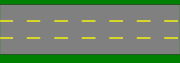
, reversible lane markings are typically a dashed or broken double yellow line on both sides. Most often done on three-lane roads, the reversible lane is typically used for traffic in one direction at morning rush hour, the opposite direction in the afternoon or evening, and as a turning lane at most other times. There is also a transition period (typically 30–60 min) between reversals during which traffic is prohibited to prevent collisions.
Sometimes, lane control signal
Lane control lights
Lane control lights are a specific type of traffic light used to manage traffic on a multi-way road or highway. Typically they allow or forbid traffic to use one or more of the available lanes by the use of Green lights or arrows or by red lights or crosses...
s are placed over the roadway at regular intervals (within sight of each other) indicating which lanes are allocated to which travel direction; a red X
X
X is the twenty-fourth letter in the basic modern Latin alphabet.-Uses:In mathematics, x is commonly used as the name for an independent variable or unknown value. The usage of x to represent an independent or unknown variable can be traced back to the Arabic word šay شيء = “thing,” used in Arabic...
indicates the lane is closed or reserved for the opposite direction; a green arrow
Arrow (symbol)
An arrow is a graphical symbol such as → or ←, used to point or indicate direction, being in its simplest form a line segment with a triangle affixed to one end, and in more complex forms a representation of an actual arrow...
indicates a permitted travel lane. The center lane is marked with either one of those (depending on time of day), and often a flashing yellow X at other times to indicate an imminent closure of a lane, becoming solid yellow before turning red. Other setups had double-turn-lane signs backlit
Backlight
A backlight is a form of illumination used in liquid crystal displays . As LCDs do not produce light themselves , they need illumination to produce a visible image...
with white fluorescent lighting instead of the flashing yellow X.
Other streets with reversible lanes (including several in Washington, D.C.
Washington, D.C.
Washington, D.C., formally the District of Columbia and commonly referred to as Washington, "the District", or simply D.C., is the capital of the United States. On July 16, 1790, the United States Congress approved the creation of a permanent national capital as permitted by the U.S. Constitution....
) simply have signs posted indicating what lanes are open to which direction when.
Separation of flows
Some more recent implementations of reversible lanes use a movable barrierBarrier transfer machine
Barrier transfer machines, also known as zipper machines, are heavy vehicles used to transfer Jersey barriers or other concrete lane dividers used to relieve traffic congestion during rush hours....
to establish a physical separation between allowed and disallowed lanes of travel. In some systems, a concrete barrier is moved during low-traffic periods to switch a central lane from one side of the road to another; some examples are the Coronado Bridge in San Diego, California
San Diego, California
San Diego is the eighth-largest city in the United States and second-largest city in California. The city is located on the coast of the Pacific Ocean in Southern California, immediately adjacent to the Mexican border. The birthplace of California, San Diego is known for its mild year-round...
, the seven lane Tappan Zee Bridge
Tappan Zee Bridge
The Governor Malcolm Wilson Tappan Zee Bridge, usually referred to as Tappan Zee Bridge, is a cantilever bridge in New York over the Hudson River at one of its widest points; the Tappan Zee is named for an American Indian tribe from the area called "Tappan"; and zee being the Dutch word for "sea"....
on the Hudson River
Hudson River
The Hudson is a river that flows from north to south through eastern New York. The highest official source is at Lake Tear of the Clouds, on the slopes of Mount Marcy in the Adirondack Mountains. The river itself officially begins in Henderson Lake in Newcomb, New York...
in New York
New York
New York is a state in the Northeastern region of the United States. It is the nation's third most populous state. New York is bordered by New Jersey and Pennsylvania to the south, and by Connecticut, Massachusetts and Vermont to the east...
and the 8 lane Auckland Harbour Bridge
Auckland Harbour Bridge
The Auckland Harbour Bridge is an eight-lane box truss motorway bridge over the Waitemata Harbour, joining St Marys Bay in Auckland with Northcote in North Shore City, New Zealand. The bridge is part of State Highway 1 and the Auckland Northern Motorway...
across the Waitemata Harbour
Waitemata Harbour
The quite famous Waitemata Harbour is the main access by sea to Auckland, New Zealand. For this reason it is often referred to as Auckland Harbour, despite the fact that it is only one of two harbours surrounding the city, and is crossed by the Auckland Harbour Bridge. The Waitemata forms the north...
in Auckland
Auckland
The Auckland metropolitan area , in the North Island of New Zealand, is the largest and most populous urban area in the country with residents, percent of the country's population. Auckland also has the largest Polynesian population of any city in the world...
, New Zealand
New Zealand
New Zealand is an island country in the south-western Pacific Ocean comprising two main landmasses and numerous smaller islands. The country is situated some east of Australia across the Tasman Sea, and roughly south of the Pacific island nations of New Caledonia, Fiji, and Tonga...
. Other systems use retractable cones or bollard
Bollard
A bollard is a short vertical post. Originally it meant a post used on a ship or a quay, principally for mooring. The word now also describes a variety of structures to control or direct road traffic, such as posts arranged in a line to obstruct the passage of motor vehicles...
s which are built into the road, or retractable fences which can divert traffic from a reversible ramp. The two center lanes of the six-lane Golden Gate Bridge
Golden Gate Bridge
The Golden Gate Bridge is a suspension bridge spanning the Golden Gate, the opening of the San Francisco Bay into the Pacific Ocean. As part of both U.S. Route 101 and California State Route 1, the structure links the city of San Francisco, on the northern tip of the San Francisco Peninsula, to...
are reversible; they are southbound during morning rush hour and northbound at evening rush hour, and are demarcated by vertical yellow markers placed manually in sockets in the roadway.
Many urban freeways have entirely separate carriageways (and connecting ramps) to hold reversible lanes (the reversible lanes in such a configuration are often referred to as "express lanes"). Generally, traffic flows in one direction or another in such a configuration (or not at all); the carriageways are not "split" into two-lane roadways during non-rush periods. Typically, this sort of express lane will have fewer interchanges than the primary lanes, and many such roadways only provide onramps for inbound traffic, and offramps for outbound traffic.
Passing lanes
Highway
A highway is any public road. In American English, the term is common and almost always designates major roads. In British English, the term designates any road open to the public. Any interconnected set of highways can be variously referred to as a "highway system", a "highway network", or a...
meant for passing
Overtaking
Overtaking or passing is the act of one vehicle going past another slower moving vehicle, travelling in the same direction, on a road. The lane used for overtaking another vehicle is almost always a lane further from the road shoulder — that is, to the left in places that drive on the right,...
in both directions. Neither direction has the right-of-way, and both directions are permitted to use the lane for passing. In a similar layout, three lanes are striped with two in one direction and one in the other, but traffic in the direction with one lane is allowed to cross the centerline to pass.
2+1 road
2+1 road
2+1 road is a specific category of three-lane road, consisting of two lanes in one direction and one lane in the other, alternating every few kilometres, and separated usually with a steel cable barrier. Traditional roads of at least width can be converted to 2+1 roads and reach near-motorway...
s have replaced some of these in Europe
Europe
Europe is, by convention, one of the world's seven continents. Comprising the westernmost peninsula of Eurasia, Europe is generally 'divided' from Asia to its east by the watershed divides of the Ural and Caucasus Mountains, the Ural River, the Caspian and Black Seas, and the waterways connecting...
and North America
North America
North America is a continent wholly within the Northern Hemisphere and almost wholly within the Western Hemisphere. It is also considered a northern subcontinent of the Americas...
.
Turn lanes / flush median

Another type of center two-way lane is a center left-turn lane (for countries which drive on the right), center turn lane or median turn lane, a single lane in the center of the road into which traffic from both directions pulls to make a left turn. While this is sometimes also called a "suicide lane", it is actually far safer, as traffic collisions occur at far lower speed
Speed
In kinematics, the speed of an object is the magnitude of its velocity ; it is thus a scalar quantity. The average speed of an object in an interval of time is the distance traveled by the object divided by the duration of the interval; the instantaneous speed is the limit of the average speed as...
s.
These roads are very common in suburban areas and less common in rural
Rural
Rural areas or the country or countryside are areas that are not urbanized, though when large areas are described, country towns and smaller cities will be included. They have a low population density, and typically much of the land is devoted to agriculture...
areas, though developed areas near Interstate Highway bypasses of a small city often have them. Many were divided highways before the median was demolished or otherwise filled with the turn lane. Many four-lane streets with a double-yellow line are being phased out in favor of five-lane streets with center turn lanes, because the center lane allows for less disruption of traffic flow. For routes with moderate traffic, other movements involve downgrading four-lane undivided streets to three-lane streets with a turn-only center lane.
This center lane can be used by emergency vehicles like police cars, ambulance, and fire trucks to avoid traffic traveling in either direction. Drivers are not allowed to use the center lane of such a highway for passing slow-moving vehicles, except when funding or space constraints dictate use of it as a rush hour "travel lane" when traffic is largely asymmetric between a central business district
Central business district
A central business district is the commercial and often geographic heart of a city. In North America this part of a city is commonly referred to as "downtown" or "city center"...
and its suburbs.
Bus transit
In bus transit, a contraflow lane is a lane reserved for busesBus rapid transit
Bus rapid transit is a term applied to a variety of public transportation systems using buses to provide faster, more efficient service than an ordinary bus line. Often this is achieved by making improvements to existing infrastructure, vehicles and scheduling...
in which the direction of bus traffic is opposite the flow of traffic on the other lanes.
No (or minimal) lane controls
- Connecticut Avenue in Washington, D.C.Washington, D.C.Washington, D.C., formally the District of Columbia and commonly referred to as Washington, "the District", or simply D.C., is the capital of the United States. On July 16, 1790, the United States Congress approved the creation of a permanent national capital as permitted by the U.S. Constitution....
- Chain BridgeChain Bridge (Washington, D.C.)The Chain Bridge is a viaduct which crosses the Potomac River at Little Falls in Washington, D.C. It carries close to 22,000 cars a day. It connects Washington with affluent sections of Arlington and Fairfax counties in Virginia. On the Washington side, the bridge connects with Canal Road...
in Washington, D.C.Washington, D.C.Washington, D.C., formally the District of Columbia and commonly referred to as Washington, "the District", or simply D.C., is the capital of the United States. On July 16, 1790, the United States Congress approved the creation of a permanent national capital as permitted by the U.S. Constitution.... - Bailey Bridge, in Coquitlam, B.C.Coquitlam, British ColumbiaCoquitlam is a city in the Lower Mainland of British Columbia, Canada. Coquitlam is mainly a suburban city, and is one of the 21 municipalities comprising Metro Vancouver. According to the 2007 Canadian Census, it is the 5th-largest city in British Columbia...
.
Lane controls and no (or minimal) physical separation
Trans-national- The Peace BridgePeace BridgeThe Peace Bridge is an international bridge between Canada and the United States at the east end of Lake Erie at the source of the Niagara River, about upriver of Niagara Falls. It connects the City of Buffalo, New York, in the United States to the Town of Fort Erie, Ontario, in Canada...
between the U.S. and Canada, connecting Fort Erie, OntarioFort Erie, OntarioFort Erie is a town on the Niagara River in the Niagara Region, Ontario, Canada. It is located directly across the river from Buffalo, New York....
to Buffalo, New YorkBuffalo, New YorkBuffalo is the second most populous city in the state of New York, after New York City. Located in Western New York on the eastern shores of Lake Erie and at the head of the Niagara River across from Fort Erie, Ontario, Buffalo is the seat of Erie County and the principal city of the...
. Three lanes total, all marked reversible, 1 reversed in the direction of rush hour flow with the possibility of all lanes flowing in the same direction based on traffic needs. - The Lewiston-Queenston BridgeLewiston-Queenston BridgeThe Lewiston–Queenston Bridge is an arch bridge that crosses the Niagara River gorge just south of the Niagara Escarpment. The bridge was officially opened on November 1, 1962. It is an international bridge between the United States and Canada. It connects Interstate 190 in the town of Lewiston,...
connecting Niagara-on-the-Lake, OntarioNiagara-on-the-Lake, OntarioNiagara-on-the-Lake is a Canadian town located in Southern Ontario where the Niagara River meets Lake Ontario in the Niagara Region of the southern part of the province of Ontario. It is located across the Niagara river from Youngstown, New York, USA...
to Lewiston, New YorkLewiston, New YorkLewiston is a village in Niagara County, New York, United States. The population was 2,781 at the 2000 census. The village is named after Morgan Lewis, an early 19th-century governor of New York. It is part of the Buffalo–Niagara Falls Metropolitan Statistical Area.The Village of Lewiston,...
. Five lanes total, all marked as reversible, 1 to 4 lanes marked daily in the same direction depending on traffic needs. In addition to the directional signals, special signals are also fitted to specify what type of vehicle may use the lane.
Australia
- The Sydney Harbour BridgeSydney Harbour BridgeThe Sydney Harbour Bridge is a steel through arch bridge across Sydney Harbour that carries rail, vehicular, bicycle and pedestrian traffic between the Sydney central business district and the North Shore. The dramatic view of the bridge, the harbour, and the nearby Sydney Opera House is an iconic...
in SydneySydneySydney is the most populous city in Australia and the state capital of New South Wales. Sydney is located on Australia's south-east coast of the Tasman Sea. As of June 2010, the greater metropolitan area had an approximate population of 4.6 million people...
, New South WalesNew South WalesNew South Wales is a state of :Australia, located in the east of the country. It is bordered by Queensland, Victoria and South Australia to the north, south and west respectively. To the east, the state is bordered by the Tasman Sea, which forms part of the Pacific Ocean. New South Wales...
(8 lanes total, 3 (formerly 4) potentially reversible, 3 reversed daily. AM peak 6 South 2 North. PM peak 3 South 5 North. Other times, 4 South 4 North), - The Spit BridgeSpit BridgeThe Spit Bridge is a bascule bridge that carries Spit Road over Middle Harbour in Sydney, New South Wales, Australia, at a point called "The Spit", 10 km north-east of the CBD. It connects the suburbs of Mosman, on the south bank and Seaforth, on the north bank...
, SydneySydneySydney is the most populous city in Australia and the state capital of New South Wales. Sydney is located on Australia's south-east coast of the Tasman Sea. As of June 2010, the greater metropolitan area had an approximate population of 4.6 million people...
, New South WalesNew South WalesNew South Wales is a state of :Australia, located in the east of the country. It is bordered by Queensland, Victoria and South Australia to the north, south and west respectively. To the east, the state is bordered by the Tasman Sea, which forms part of the Pacific Ocean. New South Wales...
(4 lanes total. AM peak 3 South, 1 North. PM peak 3 North, 1 South. All other times 2 North, 2 South). - The Alfords Point BridgeAlfords Point Bridge, New South WalesAlfords Point Bridge is one of three major road crossings of the lower Georges River. It was opened on the 7 September 1973. The bridge links Padstow Heights in the City of Bankstown to Alfords Point in the Sutherland Shire...
in the south-western suburbs of SydneySydneySydney is the most populous city in Australia and the state capital of New South Wales. Sydney is located on Australia's south-east coast of the Tasman Sea. As of June 2010, the greater metropolitan area had an approximate population of 4.6 million people...
, New South WalesNew South WalesNew South Wales is a state of :Australia, located in the east of the country. It is bordered by Queensland, Victoria and South Australia to the north, south and west respectively. To the east, the state is bordered by the Tasman Sea, which forms part of the Pacific Ocean. New South Wales...
. 3 lanes total, with the centre lane reversible using manual placement of plastic bollards. Originally this bridge was built with two lanes, and was to be part of twin spans, but only the foundations and excavations for approach works were built for the Eastern span, and the bridge was opened with one lane used in each direction. New approach works commenced in January 2007 for the second span, at a cost of 45 million AUD, eliminating the need for a reversible lane. However, a 300-metre reversible centre lane will still remain on Alfords Point Road over Henry Lawson Drive, approximately 500 meters north of this proposed bridge. - General Holmes Drive generally has 4 north lanes and 4 south lanes, but during morning peak hour one southbound lane is divided from the others with a plastic island with signs placed along the top. The island is shifted across by the RTA with a specialized vehicle. This lane is used as a northbound lane for local traffic to get to Botany and Mascot from the St George area.
- Flagstaff Road in the southern suburbs of AdelaideAdelaideAdelaide is the capital city of South Australia and the fifth-largest city in Australia. Adelaide has an estimated population of more than 1.2 million...
, South AustraliaSouth AustraliaSouth Australia is a state of Australia in the southern central part of the country. It covers some of the most arid parts of the continent; with a total land area of , it is the fourth largest of Australia's six states and two territories.South Australia shares borders with all of the mainland...
. 3 lanes total, with the centre lane reversible. - Johnston Street, MelbourneMelbourneMelbourne is the capital and most populous city in the state of Victoria, and the second most populous city in Australia. The Melbourne City Centre is the hub of the greater metropolitan area and the Census statistical division—of which "Melbourne" is the common name. As of June 2009, the greater...
, VictoriaVictoria (Australia)Victoria is the second most populous state in Australia. Geographically the smallest mainland state, Victoria is bordered by New South Wales, South Australia, and Tasmania on Boundary Islet to the north, west and south respectively....
. 5 lanes total, with the centre lane reversible. - Queens Road, Melbourne, Victoria. 5 lanes total, with the centre lane reversible.
- Tasman BridgeTasman BridgeThe Tasman Bridge is a five-lane bridge crossing the Derwent River, near the CBD of Hobart, Tasmania. The bridge has a total length of 1,395 metres . It provides the main traffic route from the CBD to the eastern shore - particularly Hobart International Airport and Bellerive Oval...
, HobartHobartHobart is the state capital and most populous city of the Australian island state of Tasmania. Founded in 1804 as a penal colony,Hobart is Australia's second oldest capital city after Sydney. In 2009, the city had a greater area population of approximately 212,019. A resident of Hobart is known as...
, TasmaniaTasmaniaTasmania is an Australian island and state. It is south of the continent, separated by Bass Strait. The state includes the island of Tasmania—the 26th largest island in the world—and the surrounding islands. The state has a population of 507,626 , of whom almost half reside in the greater Hobart...
. 5 lanes total, with center lane reversible
Canada
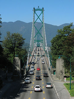
- The Lions' Gate BridgeLions' Gate BridgeThe Lions Gate Bridge, officially known as the First Narrows Bridge, is a suspension bridge that crosses the first narrows of Burrard Inlet and connects the City of Vancouver, British Columbia, to the North Shore municipalities of the District of North Vancouver, the City of North Vancouver, and...
in VancouverVancouverVancouver is a coastal seaport city on the mainland of British Columbia, Canada. It is the hub of Greater Vancouver, which, with over 2.3 million residents, is the third most populous metropolitan area in the country,...
(3 lanes total, 1 reversible) - The Angus L. Macdonald BridgeAngus L. Macdonald BridgeThe Angus L. Macdonald Bridge, locally known as "the old bridge", is a suspension bridge crossing Halifax Harbour in Nova Scotia, Canada; it opened on April 2, 1955....
, Chebucto Road and the Herring Cove Road in Halifax, Nova Scotia (3 lanes total, 1 reversible) - Jarvis StreetJarvis StreetJarvis Street is a north-south thoroughfare in downtown Toronto, Ontario, Canada, passing through some of the oldest developed areas in the city. Its alignment extends from Bloor Street in the north to Queens Quay East in the south. South of Front Street, it continues as Lower Jarvis Street...
in downtown TorontoTorontoToronto is the provincial capital of Ontario and the largest city in Canada. It is located in Southern Ontario on the northwestern shore of Lake Ontario. A relatively modern city, Toronto's history dates back to the late-18th century, when its land was first purchased by the British monarchy from...
(5 lanes total, centre lane reversed daily for AM/PM rush hours) - now converted to 2 lanes each direction + bicycle lane - The Champlain BridgeChamplain Bridge (Ottawa)The Champlain Bridge crosses the Ottawa River about west of Parliament Hill, joining the communities of Ottawa, Ontario and Gatineau, Quebec. It is the westernmost link between the two cities....
in OttawaOttawaOttawa is the capital of Canada, the second largest city in the Province of Ontario, and the fourth largest city in the country. The city is located on the south bank of the Ottawa River in the eastern portion of Southern Ontario...
(3 lanes total; 1 reversible) - Sherman Access and Sherman Cut in Hamilton, OntarioHamilton, OntarioHamilton is a port city in the Canadian province of Ontario. Conceived by George Hamilton when he purchased the Durand farm shortly after the War of 1812, Hamilton has become the centre of a densely populated and industrialized region at the west end of Lake Ontario known as the Golden Horseshoe...
(2 lanes, both reversible) - The George Massey TunnelGeorge Massey TunnelThe George Massey Tunnel is a highway traffic tunnel in the Metro Vancouver region of southwestern British Columbia. It is located approximately 20 km south of the city centre of Vancouver, British Columbia, and approximately 30 km north of the Canada-U.S...
in DeltaDelta, British ColumbiaDelta is a district municipality in British Columbia, and forms part of Metro Vancouver. Located south of Richmond, it is bordered by the Fraser River to the north, the United States to the south and the city of Surrey to the east...
and Richmond, B.C.Richmond, British ColumbiaRichmond is a coastal city, incorporated in the Canadian province of British Columbia. Part of Metro Vancouver, its neighbouring communities are Vancouver and Burnaby to the north, New Westminster to the east, and Delta to the south, while the Strait of Georgia forms its western border...
(4 lanes total, 2 reversible, with access controlled by gates) - Connors Road in EdmontonEdmontonEdmonton is the capital of the Canadian province of Alberta and is the province's second-largest city. Edmonton is located on the North Saskatchewan River and is the centre of the Edmonton Capital Region, which is surrounded by the central region of the province.The city and its census...
(4 lanes, 3 reversible) - 170th Street from north of 137th Avenue137 Avenue, Edmonton137 Avenue is a major arterial road in north Edmonton, Alberta, Canada. This road travels through residential, industrial and commercial areas, including shopping and entertainment centres and districts....
to Levasseur Road in Edmonton (3 lanes total, 1 reversible) - 97th Street from 118th Avenue to 127th Avenue in Edmonton (7 lanes total, 3 reversible)
- Centre Street from 20th Avenue N to 6th Avenue S in CalgaryCalgaryCalgary is a city in the Province of Alberta, Canada. It is located in the south of the province, in an area of foothills and prairie, approximately east of the front ranges of the Canadian Rockies...
(4 lanes total, 2 reversible; standard configuration is 2 out, 2 in; morning rush is 1 out, 3 in; and evening rush is 3 out, 1 in) - 10th Street NW / 9th Street SW from 5th Avenue NW to 4th Avenue SW in Calgary (4 lanes total, 2 reversible; standard configuration is 2 out, 2 in; morning rush is 1 out, 3 in; and evening rush is 3 out, 1 in)
- Park AvenuePark Avenue, MontrealPark Avenue is one of central Montreal's major north-south streets. It derives its name from Mount Royal park, by which it runs. Between Mount Royal Avenue and Pine Avenue, the street serves as the boundary between the mountain, to the west, and the smaller Jeanne Mance Park to the east...
in MontrealMontrealMontreal is a city in Canada. It is the largest city in the province of Quebec, the second-largest city in Canada and the seventh largest in North America...
, five lanes total, centremost lane is reversible, sidemost lanes are reserved for public transportPublic transportPublic transport is a shared passenger transportation service which is available for use by the general public, as distinct from modes such as taxicab, car pooling or hired buses which are not shared by strangers without private arrangement.Public transport modes include buses, trolleybuses, trams...
during rush hour; morning rush is 2 in, one out (not including bus lanes), evening rush is reversed - Champlain Bridge in Montreal, rush hour bus laneBus laneA bus lane or bus only lane is a lane restricted to buses, and generally used to speed up public transport that would be otherwise held up by traffic congestion...
s - Jacques Cartier BridgeJacques Cartier BridgeThe Jacques Cartier Bridge is a steel truss cantilever bridge crossing the Saint Lawrence River from Montreal Island, Montreal, Quebec to the south shore at Longueuil, Quebec, Canada...
in Montreal, five lanes total, two for both directions, one rush hour central reversible lane - During the 2010 Winter Olympics2010 Winter OlympicsThe 2010 Winter Olympics, officially the XXI Olympic Winter Games or the 21st Winter Olympics, were a major international multi-sport event held from February 12–28, 2010, in Vancouver, British Columbia, Canada, with some events held in the suburbs of Richmond, West Vancouver and the University...
, British Columbia Highway 99 was subject to lane control in three-lane sections of the highway, via signs on the side of the road that were changed manually.
Croatia
- State Route 102D102 (Croatia)D102 is a state road connecting the mainland to island of Krk and terminating at the southern tip of the island in Baška. The road is 48.3 km long....
near KraljevicaKraljevicaKraljevica is a town in the Kvarner region of the country of Croatia, located between Rijeka and Crikvenica, approximately thirty kilometers from Opatija and near the entrance to the bridge to the island of Krk...
leading southbound to the Krk BridgeKrk BridgeKrk Bridge is a 1430 m long reinforced concrete arch bridge connecting the Croatian island of Krk to the mainland and carrying over a million vehicles per year. The longer of the bridge's two arches is the second longest concrete arch in the world and among the longest arches of any construction...
used to have a three-lane passing lane combination, blind curves, and a steep grade. It was later changed to a passing lane combination that makes the northbound traffic dominant.
Turkey
- Reversible lanes are frequently used in hilly sections of highways with heavy truck traffic. Most of them were built during the 1980s and 1990s.
United Kingdom
- The A38A38A38 or A-38 may refer to:* A38 , a fermented dairy product sold in Denmark* A38 , a party boat on the Danube in Budapest, Hungary* A38 motorway * A38 road * Bundesautobahn 38, an autobahn in Germany...
road across the Tamar BridgeTamar BridgeThe Tamar Bridge is a major road bridge at Saltash in southwest England carrying traffic between Cornwall and Devon. When it opened in 1961 it was the longest suspension bridge in the United Kingdom...
and through the Saltash TunnelSaltash TunnelThe Saltash Tunnel is a road tunnel on the A38 at Saltash in Cornwall, UK and was opened in 1988.The central lane operates as a reversible lane to cope with holiday and rush hour traffic and the speed limit is 30 mph. The tunnel is used by more than 38,000 motorists per day and is 410 m long...
in SaltashSaltashSaltash is a town and civil parish in Cornwall, England, United Kingdom. It has a population of 14,964. It lies in the south east of Cornwall, facing Plymouth over the River Tamar. It was in the Caradon district until March 2009 and is known as "the gateway to Cornwall". Saltash means ash tree by...
, EnglandEnglandEngland is a country that is part of the United Kingdom. It shares land borders with Scotland to the north and Wales to the west; the Irish Sea is to the north west, the Celtic Sea to the south west, with the North Sea to the east and the English Channel to the south separating it from continental...
. The middle lane is reversible, allowing for control of traffic flows in holiday periods and during rush hour. - The A61A61 roadThe A61 is a major trunk road in England. It runs from Derby to Thirsk in North Yorkshire. From Derby, it heads north via Alfreton, Clay Cross, Chesterfield, Sheffield, Barnsley, Wakefield, Leeds, Harrogate and Ripon...
Queens Road in SheffieldSheffieldSheffield is a city and metropolitan borough of South Yorkshire, England. Its name derives from the River Sheaf, which runs through the city. Historically a part of the West Riding of Yorkshire, and with some of its southern suburbs annexed from Derbyshire, the city has grown from its largely...
, EnglandEnglandEngland is a country that is part of the United Kingdom. It shares land borders with Scotland to the north and Wales to the west; the Irish Sea is to the north west, the Celtic Sea to the south west, with the North Sea to the east and the English Channel to the south separating it from continental...
, although it is a very short section (4 lanes total, 1 reversible: allowing for either 3 out, 1 in, or 2 out, 2 in). - The A470A470 roadThe A470 is a major long-distance connective spine road in Wales, running from Cardiff on the south coast to Llandudno on the north coast. It covers approximately 186 miles , over a zig-zagging route through the entirety of the country's mountainous central region, including the Brecon Beacons and...
North Road in CardiffCardiffCardiff is the capital, largest city and most populous county of Wales and the 10th largest city in the United Kingdom. The city is Wales' chief commercial centre, the base for most national cultural and sporting institutions, the Welsh national media, and the seat of the National Assembly for...
, WalesWalesWales is a country that is part of the United Kingdom and the island of Great Britain, bordered by England to its east and the Atlantic Ocean and Irish Sea to its west. It has a population of three million, and a total area of 20,779 km²...
, A section of around 1 mile long between the Maindy Road Junction and College Avenue where the road drops from a dual two-lane to a three-lane section. One lane is always dedicated to Northbound (out of town) traffic, and one lane to Southbound (city centre bound traffic) with the centre lane reversing depending on the time of day - i.e. in the morning 2 lanes into the city, 1 lane out, in the evening 2 lanes out of the city, 1 lane in. - The A15 in Lincoln (Canwick Road) has a short three-lane section of tidal flow.
United States
Alabama
Alabama
Alabama is a state located in the southeastern region of the United States. It is bordered by Tennessee to the north, Georgia to the east, Florida and the Gulf of Mexico to the south, and Mississippi to the west. Alabama ranks 30th in total land area and ranks second in the size of its inland...
- In MontgomeryMontgomery, AlabamaMontgomery is the capital of the U.S. state of Alabama, and is the county seat of Montgomery County. It is located on the Alabama River southeast of the center of the state, in the Gulf Coastal Plain. As of the 2010 census, Montgomery had a population of 205,764 making it the second-largest city...
, Norman Bridge Road through the Garden District and Old Cloverdale has a center lane with reversible markings and traffic flow lights between Burton Street and Legrand Place.
Alaska
Alaska
Alaska is the largest state in the United States by area. It is situated in the northwest extremity of the North American continent, with Canada to the east, the Arctic Ocean to the north, and the Pacific Ocean to the west and south, with Russia further west across the Bering Strait...
- The Anton Anderson Memorial TunnelAnton Anderson Memorial TunnelThe Anton Anderson Memorial Tunnel is a tunnel through Maynard Mountain in the U.S. state of Alaska. It links the Seward Highway south of Anchorage at the former town of Portage with the relatively isolated community of Whittier, a port for the Alaska Marine Highway...
between PortagePortage, AlaskaPortage is a former settlement on Turnagain Arm in Alaska, about south of Anchorage. The town was destroyed almost entirely in the 1964 Good Friday Earthquake when the ground in the area sank about six feet, putting most of it below sea level. All that remains today are the ruins of a few...
and WhittierWhittier, AlaskaWhittier is a city in the Valdez-Cordova Census Area, in the U.S. state of Alaska. As of 2006, the population was 177. The city is also a port for the Alaska Marine Highway.-Geography:...
is a 13,300 feet (4,050 m) long, reversible single lane tunnel, shared between vehicular traffic and trains. The direction of traffic alternates every 15 minutes, with periods allowed for train traffic each day.
Arizona
Arizona
Arizona ; is a state located in the southwestern region of the United States. It is also part of the western United States and the mountain west. The capital and largest city is Phoenix...
- In PhoenixPhoenix, ArizonaPhoenix is the capital, and largest city, of the U.S. state of Arizona, as well as the sixth most populated city in the United States. Phoenix is home to 1,445,632 people according to the official 2010 U.S. Census Bureau data...
on 7th Avenue between McDowell Road and Northern Avenue, and 7th Street between McDowell Road and Cave Creek Road/Dunlap Avenue. On both roads, the lane configuration is 2 southbound and 3 northbound, with the center lane open for southbound traffic between 6-9am and open to northbound traffic between 3-6pm. Left turns are prohibited from the reversible lane at most arterial and collector street intersections during these hours but still allowed at driveways and non-signaled street intersections.
California
California
California is a state located on the West Coast of the United States. It is by far the most populous U.S. state, and the third-largest by land area...
- The Golden Gate BridgeGolden Gate BridgeThe Golden Gate Bridge is a suspension bridge spanning the Golden Gate, the opening of the San Francisco Bay into the Pacific Ocean. As part of both U.S. Route 101 and California State Route 1, the structure links the city of San Francisco, on the northern tip of the San Francisco Peninsula, to...
(6 lanes total, 2 reversible, vertical median markers provide minimal physical separation) connecting San Francisco with suburban Marin County - Doyle Drive (U.S. Route 101U.S. Route 101U.S. Route 101, or U.S. Highway 101, is an important north–south U.S. highway that runs through the states of California, Oregon, and Washington, on the West Coast of the United States...
) in San Francisco - Lafayette Street in Santa ClaraSanta Clara, CaliforniaSanta Clara , founded in 1777 and incorporated in 1852, is a city in Santa Clara County, in the U.S. state of California. The city is the site of the eighth of 21 California missions, Mission Santa Clara de Asís, and was named after the mission. The Mission and Mission Gardens are located on the...
- the center lane is used for northbound traffic on weekday mornings, southbound traffic for weekday afternoons, and as a center turning lane at other times. - The Baker-Barry Tunnel, one of only two means of access to the Marin HeadlandsMarin HeadlandsThe Marin Headlands is a hilly area at the southernmost end of Marin County, California, just north of the Golden Gate Bridge. The Headlands are located just north of San Francisco, immediately across the Golden Gate Bridge. The entire area is part of the Golden Gate National Recreation Area...
from U.S. Route 101 in Marin County, is not wide enough to accommodate bidirectional traffic. It consists of a single reversible lane for automobiles and two bicycle lanes. The direction of automobile traffic alternates every five minutes, controlled by a traffic light at each end of the tunnel. The bicycle lanes, one for each direction, are located on either side of the reversible lane; buttons on either side of the tunnel trigger flashing signs alerting drivers entering the tunnel to the presence of cyclists.
Connecticut
Connecticut
Connecticut is a state in the New England region of the northeastern United States. It is bordered by Rhode Island to the east, Massachusetts to the north, and the state of New York to the west and the south .Connecticut is named for the Connecticut River, the major U.S. river that approximately...
- Asylum Avenue in HartfordHartford, ConnecticutHartford is the capital of the U.S. state of Connecticut. The seat of Hartford County until Connecticut disbanded county government in 1960, it is the second most populous city on New England's largest river, the Connecticut River. As of the 2010 Census, Hartford's population was 124,775, making...
Florida
Florida
Florida is a state in the southeastern United States, located on the nation's Atlantic and Gulf coasts. It is bordered to the west by the Gulf of Mexico, to the north by Alabama and Georgia and to the east by the Atlantic Ocean. With a population of 18,801,310 as measured by the 2010 census, it...
- Bay Street in JacksonvilleJacksonville, FloridaJacksonville is the largest city in the U.S. state of Florida in terms of both population and land area, and the largest city by area in the contiguous United States. It is the county seat of Duval County, with which the city government consolidated in 1968...
Georgia
Georgia (U.S. state)
Georgia is a state located in the southeastern United States. It was established in 1732, the last of the original Thirteen Colonies. The state is named after King George II of Great Britain. Georgia was the fourth state to ratify the United States Constitution, on January 2, 1788...
- Northside Drive in AtlantaAtlanta, GeorgiaAtlanta is the capital and most populous city in the U.S. state of Georgia. According to the 2010 census, Atlanta's population is 420,003. Atlanta is the cultural and economic center of the Atlanta metropolitan area, which is home to 5,268,860 people and is the ninth largest metropolitan area in...
: the center lane of three is reversed using overhead lane-use control signals. - Vineville Avenue in MaconMacon, GeorgiaMacon is a city located in central Georgia, US. Founded at the fall line of the Ocmulgee River, it is part of the Macon metropolitan area, and the county seat of Bibb County. A small portion of the city extends into Jones County. Macon is the biggest city in central Georgia...
: the center lane of three is reversed using overhead lane-use control signals.
Kentucky
Kentucky
The Commonwealth of Kentucky is a state located in the East Central United States of America. As classified by the United States Census Bureau, Kentucky is a Southern state, more specifically in the East South Central region. Kentucky is one of four U.S. states constituted as a commonwealth...
- The Clay Wade Bailey BridgeClay Wade Bailey BridgeThe Clay Wade Bailey Bridge is a cantilever bridge carrying U.S. Route 42 and U.S. Route 127 across the Ohio River, connecting Cincinnati, Ohio and Covington, Kentucky. This also marks the termination of U.S. Route 25. The bridge's main span is...
in CovingtonCovington, Kentucky-Demographics:As of the census of 2000, there were 43,370 people, 18,257 households, and 10,132 families residing in the city. The population density was 3,301.3 people per square mile . There were 20,448 housing units at an average density of 1,556.5 per square mile...
(3 lanes total, 1 reversible) - Nicholasville Road (U.S. Highway 27) in LexingtonLexington, KentuckyLexington is the second-largest city in Kentucky and the 63rd largest in the US. Known as the "Thoroughbred City" and the "Horse Capital of the World", it is located in the heart of Kentucky's Bluegrass region...
, has reversible lanes (lane signals, no physical separation) starting at its intersection with Rose Street at the University of KentuckyUniversity of KentuckyThe University of Kentucky, also known as UK, is a public co-educational university and is one of the state's two land-grant universities, located in Lexington, Kentucky...
campus and ending at New Circle RoadNew Circle RoadNew Circle Road, also known as Kentucky Route 4, is a Kentucky state highway that serves as an inner beltway around Lexington, which is part of the consolidated city-county government with Fayette County....
, the city's inner beltway. During morning rush hour, as well as the hours before UK footballKentucky Wildcats footballThe Kentucky Wildcats football team is a college football program that competes in the NCAA Division I Football Bowl Subdivision and the East Division of the Southeastern Conference.-History:Paul "Bear" Bryant Era...
homeCommonwealth Stadium (Kentucky)Commonwealth Stadium is the name of a stadium in Lexington, Kentucky, USA. This stadium, named for the Commonwealth of Kentucky, is located on the campus of the University of Kentucky and is the home field for the school's football team, replacing the smaller Stoll Field/McLean Stadium. The field...
games, southbound traffic (away from the UK campus and downtown) is restricted to one lane between campus and Southland Drive, and two lanes from Southland to New Circle. Northbound traffic faces the same restrictions in the evening rush hour and immediately after football games. During off-peak hours, an equal number of lanes are dedicated to traffic in each direction. - Baxter Avenue and Bardstown Road (U.S. Highway 31E) in LouisvilleLouisville, KentuckyLouisville is the largest city in the U.S. state of Kentucky, and the county seat of Jefferson County. Since 2003, the city's borders have been coterminous with those of the county because of a city-county merger. The city's population at the 2010 census was 741,096...
have reversible lanes (lane signals without any physical separation) for 2½ miles starting at their intersection with Lexington Road in the north and ending at Douglass Boulevard in the south. This stretch of road has four lanes, but on-street parking frequently restricts traffic to one lane in each direction outside of rush hours. During rush hours, parking is prohibited north of Douglass Boulevard. Southbound traffic leaving downtown LouisvilleDowntown LouisvilleDowntown Louisville is the largest central business district in the Commonwealth of Kentucky and the urban hub of the Louisville, Kentucky Metropolitan Area. Its boundaries are the Ohio River to the north, Hancock Street to the east, York and Jacob Streets to the south, and 9th Street to the west...
is restricted to one lane during the morning rush hour, with northbound traffic having the same restriction during the evening rush hour. Also, the lane immediately to the left of rush-hour through traffic becomes a dedicated left-turn lane. Electronic signs over the roadway alert motorists to the traffic flow dedication of each lane.
Indiana
Indiana
Indiana is a US state, admitted to the United States as the 19th on December 11, 1816. It is located in the Midwestern United States and Great Lakes Region. With 6,483,802 residents, the state is ranked 15th in population and 16th in population density. Indiana is ranked 38th in land area and is...
- In IndianapolisIndianapolisIndianapolis is the capital of the U.S. state of Indiana, and the county seat of Marion County, Indiana. As of the 2010 United States Census, the city's population is 839,489. It is by far Indiana's largest city and, as of the 2010 U.S...
, Fall Creek Parkway North Drive between Central Avenue and Evanston Avenue has 5 lanes (7 in some sections) with 1 lane marked as reversible. Configuration is typically designed to allow for 3 in 2 out during morning rush hours, and 2 in/3 out during afternoon rush hours. Due to Fall Creek Parkway's proximity to the Indiana State Fairgrounds, lane configurations change periodically to facilitate traffic flow during events at the fairgrounds.
Maryland
Maryland
Maryland is a U.S. state located in the Mid Atlantic region of the United States, bordering Virginia, West Virginia, and the District of Columbia to its south and west; Pennsylvania to its north; and Delaware to its east...
- The Chesapeake Bay BridgeChesapeake Bay BridgeThe Chesapeake Bay Bridge is a major dual-span bridge in the U.S. state of Maryland. Spanning the Chesapeake Bay, it connects the state's rural Eastern Shore region with the more urban Western Shore. The original span opened in 1952 and, at the time, with a length of , it was the world's longest...
near AnnapolisAnnapolis, MarylandAnnapolis is the capital of the U.S. state of Maryland, as well as the county seat of Anne Arundel County. It had a population of 38,394 at the 2010 census and is situated on the Chesapeake Bay at the mouth of the Severn River, south of Baltimore and about east of Washington, D.C. Annapolis is...
(5 lanes total, all marked reversible, 1 usually reversed for normal peak traffic). However, due to its dual spans, when there are 2 eastbound lanes and 3 westbound the opposing sides are completely divided, this is the usual configuration. - The Hanover Street Bridge in BaltimoreBaltimoreBaltimore is the largest independent city in the United States and the largest city and cultural center of the US state of Maryland. The city is located in central Maryland along the tidal portion of the Patapsco River, an arm of the Chesapeake Bay. Baltimore is sometimes referred to as Baltimore...
has 5 lanes total marked reversible, with 1 usually reversed for normal peak traffic). - Georgia AvenueGeorgia AvenueGeorgia Avenue is a major north-south artery in Northwest Washington, D.C. and Montgomery County, Maryland. Within the District of Columbia and a short distance in Silver Spring, Maryland, Georgia Avenue is also U.S. Route 29...
in Silver SpringSilver Spring, MarylandSilver Spring is an unincorporated area and census-designated place in Montgomery County, Maryland, United States. It had a population of 71,452 at the 2010 census, making it the fourth most populous place in Maryland, after Baltimore, Columbia, and Germantown.The urbanized, oldest, and...
has 7 lanes. During most hours, the center lane is marked with a yellow lit X as a left turn lane for both directions. During morning and evening rush hours, the lane is marked with a down facing green arrow – southbound in the morning, northbound in the evening – or a red X – northbound in the morning, southbound in the evening – and left turns are prohibited. - Colesville RoadU.S. Route 29 in MarylandU.S. Route 29 is a north–south United States highway that runs for from the western suburbs of Baltimore, Maryland, to Pensacola, Florida. In the U.S. state of Maryland, US 29 is a major highway that emerges from Washington D.C. and runs north into eastern Montgomery County, stretching...
in Silver SpringSilver Spring, MarylandSilver Spring is an unincorporated area and census-designated place in Montgomery County, Maryland, United States. It had a population of 71,452 at the 2010 census, making it the fourth most populous place in Maryland, after Baltimore, Columbia, and Germantown.The urbanized, oldest, and...
has 6 lanes. During off-rush hours, three lanes go in each direction. During morning rush hours, four lanes (marked with green arrows) go southbound, while northbound (marked with Xs in those lanes) is relegated to two lanes. During afternoon rush, the process is reversed.
Michigan
Michigan
Michigan is a U.S. state located in the Great Lakes Region of the United States of America. The name Michigan is the French form of the Ojibwa word mishigamaa, meaning "large water" or "large lake"....
- The Mackinac BridgeMackinac BridgeThe Mackinac Bridge is a suspension bridge spanning the Straits of Mackinac to connect the non-contiguous Upper and Lower peninsulas of the U.S. state of Michigan. Opened in 1957, the bridge is the third longest in total suspension in the world and the longest suspension bridge between anchorages...
near St. Ignace treats the passing lane of the southbound side as a temporary northbound lane during the Labor DayLabor DayLabor Day is a United States federal holiday observed on the first Monday in September that celebrates the economic and social contributions of workers.-History:...
bridge walk, at which time the northbound side is used for pedestrians.
Nebraska
Nebraska
Nebraska is a state on the Great Plains of the Midwestern United States. The state's capital is Lincoln and its largest city is Omaha, on the Missouri River....
- Dodge Street between Turner Boulevard and 68th Street in OmahaOmaha, NebraskaOmaha is the largest city in the state of Nebraska, United States, and is the county seat of Douglas County. It is located in the Midwestern United States on the Missouri River, about 20 miles north of the mouth of the Platte River...
: no physical separation; lanes marked with overhead lane-use control signals. Center lane direction is eastbound from 5am-9am and westbound from 9am-5am. - Farnam Street between Saddle Creek Road and 57th Street in OmahaOmaha, NebraskaOmaha is the largest city in the state of Nebraska, United States, and is the county seat of Douglas County. It is located in the Midwestern United States on the Missouri River, about 20 miles north of the mouth of the Platte River...
: no physical separation; lanes marked with lane-use control signals and LEDLight-emitting diodeA light-emitting diode is a semiconductor light source. LEDs are used as indicator lamps in many devices and are increasingly used for other lighting...
signs. On weekdays the direction is one-way eastbound 7am-9am, and one-way westbound 4pm-6pm.
New York
New York
New York is a state in the Northeastern region of the United States. It is the nation's third most populous state. New York is bordered by New Jersey and Pennsylvania to the south, and by Connecticut, Massachusetts and Vermont to the east...
- Delancey Street in New York CityNew York CityNew York is the most populous city in the United States and the center of the New York Metropolitan Area, one of the most populous metropolitan areas in the world. New York exerts a significant impact upon global commerce, finance, media, art, fashion, research, technology, education, and...
has two lanes on the eastbound side adjacent to the median used for westbound traffic in the morning rush hour between the Williamsburg BridgeWilliamsburg BridgeThe Williamsburg Bridge is a suspension bridge in New York City across the East River connecting the Lower East Side of Manhattan at Delancey Street with the Williamsburg neighborhood of Brooklyn at Broadway near the Brooklyn-Queens Expressway...
and Allen Street. All traffic in these lanes must continue to and then turn left onto Allen, during these times left turns are prohibited from the regular westbound roadway onto Allen Street. - Manhattan BridgeManhattan BridgeThe Manhattan Bridge is a suspension bridge that crosses the East River in New York City, connecting Lower Manhattan with Brooklyn . It was the last of the three suspension bridges built across the lower East River, following the Brooklyn and the Williamsburg bridges...
(New York CityNew York CityNew York is the most populous city in the United States and the center of the New York Metropolitan Area, one of the most populous metropolitan areas in the world. New York exerts a significant impact upon global commerce, finance, media, art, fashion, research, technology, education, and...
) lower level has three lanes, which can have all lanes used in one direction or reversible with two lanes one way and the other for the opposite direction. - The upper level of the Queensboro BridgeQueensboro BridgeThe Ed Koch Queensboro Bridge, also known as the 59th Street Bridge – because its Manhattan end is located between 59th and 60th Streets – or simply the Queensboro Bridge, is a cantilever bridge over the East River in New York City that was completed in 1909...
in New York CityNew York CityNew York is the most populous city in the United States and the center of the New York Metropolitan Area, one of the most populous metropolitan areas in the world. New York exerts a significant impact upon global commerce, finance, media, art, fashion, research, technology, education, and...
has 4 lanes and can have all flowing outbound (PM peak), or two lanes each direction in normal configuration. - The Mid-Hudson BridgeMid-Hudson BridgeThe Mid-Hudson Bridge is a toll suspension bridge which carries US 44 and NY 55 across the Hudson River between Poughkeepsie and Highland in the state of New York. Governor and local resident Franklin D. Roosevelt and his wife Eleanor attended the opening ceremony on August 25, 1930. The bridge...
in Poughkeepsie, New York has a reversible center lane used during rush hour.
North Carolina
North Carolina
North Carolina is a state located in the southeastern United States. The state borders South Carolina and Georgia to the south, Tennessee to the west and Virginia to the north. North Carolina contains 100 counties. Its capital is Raleigh, and its largest city is Charlotte...
- East 7th Street in CharlotteCharlotte, North CarolinaCharlotte is the largest city in the U.S. state of North Carolina and the seat of Mecklenburg County. In 2010, Charlotte's population according to the US Census Bureau was 731,424, making it the 17th largest city in the United States based on population. The Charlotte metropolitan area had a 2009...
- Tyvola Road in CharlotteCharlotte, North CarolinaCharlotte is the largest city in the U.S. state of North Carolina and the seat of Mecklenburg County. In 2010, Charlotte's population according to the US Census Bureau was 731,424, making it the 17th largest city in the United States based on population. The Charlotte metropolitan area had a 2009...
- Since the closure (2005) and implosion (2007) of the former Charlotte Coliseum (II), this road is no longer reversible; all lights have been removed and lane signs are permanent. It was designed this way for Coliseum traffic from NBA games and concerts.
- U.S. Route 29U.S. Route 29U.S. Route 29 is a north–south United States highway that runs for from the western suburbs of Baltimore, Maryland, to Pensacola, Florida. This highway's northern terminus is at Maryland Route 99 in Ellicott City, Maryland...
in CharlotteCharlotte, North CarolinaCharlotte is the largest city in the U.S. state of North Carolina and the seat of Mecklenburg County. In 2010, Charlotte's population according to the US Census Bureau was 731,424, making it the 17th largest city in the United States based on population. The Charlotte metropolitan area had a 2009...
- This road is the access road to Charlotte Motor SpeedwayCharlotte Motor SpeedwayCharlotte Motor Speedway is a motorsports complex located in Concord, North Carolina, United States 13 miles from Charlotte, North Carolina. The complex features a quad oval track that hosts NASCAR racing including the prestigious Coca-Cola 600 on Memorial Day weekend and the Sprint All-Star Race...
from the city, and links to Interstate 485. It is used for any events at the Speedway.
- This road is the access road to Charlotte Motor Speedway
- High Point Road in GreensboroGreensboro, North CarolinaGreensboro is a city in the U.S. state of North Carolina. It is the third-largest city by population in North Carolina and the largest city in Guilford County and the surrounding Piedmont Triad metropolitan region. According to the 2010 U.S...
- Edwards Mill Road in RaleighRaleigh, North CarolinaRaleigh is the capital and the second largest city in the state of North Carolina as well as the seat of Wake County. Raleigh is known as the "City of Oaks" for its many oak trees. According to the U.S. Census Bureau, the city's 2010 population was 403,892, over an area of , making Raleigh...
Ohio
Ohio
Ohio is a Midwestern state in the United States. The 34th largest state by area in the U.S.,it is the 7th‑most populous with over 11.5 million residents, containing several major American cities and seven metropolitan areas with populations of 500,000 or more.The state's capital is Columbus...
- At least one road in SanduskySandusky, OhioSandusky is a city in the U.S. state of Ohio and the county seat of Erie County. It is located in northern Ohio and is situated on the shores of Lake Erie, almost exactly half-way between Toledo to the west and Cleveland to the east....
has reversible lanes, for the purpose of allowing quick departure of Cedar PointCedar PointCedar Point is a 364 acre amusement park located in Sandusky, Ohio, United States on a narrow peninsula jutting into Lake Erie. Cedar Point is the only amusement park with four roller coasters that are taller than...
guests.
Pennsylvania
Pennsylvania
The Commonwealth of Pennsylvania is a U.S. state that is located in the Northeastern and Mid-Atlantic regions of the United States. The state borders Delaware and Maryland to the south, West Virginia to the southwest, Ohio to the west, New York and Ontario, Canada, to the north, and New Jersey to...
- The Liberty BridgeLiberty Bridge (Pittsburgh)The Liberty Bridge, completed in 1928, connects downtown Pittsburgh, Pennsylvania to the Liberty Tunnels and the South Hills neighborhoods beyond...
near the southern terminus of I-579 in Pittsburgh has 4 lanes, all of which are potentially reversible, and 2 of which are reversed based on rush-hour times. - The West End Bridge in Pittsburgh has 4 lanes, which are all potentially reversible.
- West General Robinson Street near Heinz Field in Pittsburgh has 4 lanes, and 2 are reversible.
Texas
Texas
Texas is the second largest U.S. state by both area and population, and the largest state by area in the contiguous United States.The name, based on the Caddo word "Tejas" meaning "friends" or "allies", was applied by the Spanish to the Caddo themselves and to the region of their settlement in...
- West Alabama Street and North Main Street in Houston – both are three-lane streets, which operate in a 2 in, 1 out configuration during the morning rush, a 1 in, 2 out configuration during the evening rush, and a 1 each way + two-way left turn lane at other times.
- Interstate highway 10 and highway 290 in Houston have contraflow HOV lanes intended to help ease rush hour traffic.
Lane controls and physical separation
- The A38(M) motorwayA38(M) motorwayThe A38, also known as the Aston Expressway, is a motorway in Birmingham, England. It is long and was opened on 24 May 1972. It forms part of the much longer A38 route....
(also known as the Aston Expressway) in BirminghamBirminghamBirmingham is a city and metropolitan borough in the West Midlands of England. It is the most populous British city outside the capital London, with a population of 1,036,900 , and lies at the heart of the West Midlands conurbation, the second most populous urban area in the United Kingdom with a...
, EnglandEnglandEngland is a country that is part of the United Kingdom. It shares land borders with Scotland to the north and Wales to the west; the Irish Sea is to the north west, the Celtic Sea to the south west, with the North Sea to the east and the English Channel to the south separating it from continental...
. The road connects the city centre with Spaghetti JunctionGravelly Hill InterchangeGravelly Hill Interchange, better known by its nickname Spaghetti Junction, is junction 6 of the M6 motorway where it meets the A38 Aston Expressway in Birmingham, England.- Overview :...
on the M6M6 motorwayThe M6 motorway runs from junction 19 of the M1 at the Catthorpe Interchange, near Rugby via Birmingham then heads north, passing Stoke-on-Trent, Manchester, Preston, Carlisle and terminating at the Gretna junction . Here, just short of the Scottish border it becomes the A74 which continues to...
. It is a 2-mile, 7-lane section of motorway with no central reservation, and a lower than usual speed limit of 50 mph. Constructed in 1971, it was the United Kingdom's first contraflow road. Overhead lane control signals allow for 4 lanes in and 2 out in the morning rush hour, reversed in the evening, and 3 lanes each way at all other times. One dividing lane is closed to traffic at all times, and motorcycles are permanently prohibited from using the central, red-surfaced lane (with a fixed sign) owing to its use as an off-camber drain. The lane control signals can be set to allow travel in either direction for any lane in exceptional circumstances, which has been used for single-lane, reduced-speed running in each direction (or 2+1 with no divider) during road work, allowing the expressway to remain largely open even during major repairs. However, the 7-lane section splits at both ends to fully divided sets of 4x2 lane slip roads, with the central red lane ending in a barrier, so full use of this flexibility is uncommon and occasional overnight closure is required. - The U.S. Route 78U.S. Route 78U.S. Highway 78 is an east–west United States highway that runs for 715 miles from Memphis, Tennessee, to Charleston, South Carolina. Between Memphis and Birmingham, Alabama, it is being upgraded to become Interstate 22....
portion in Snellville, GA, United StatesUnited StatesThe United States of America is a federal constitutional republic comprising fifty states and a federal district...
, has 6 lanes in total. This occurs from the limited access portion through Stone Mountain Park to G.A. State Route 124 (Scenic Highway) for several miles. The middle two lanes are reversible (usually occurring during rush hour) with a varying lane always reserved a center turn lane while the 3 lanes are used for one side and 2 for the other. Example of an intersection on U.S. 78. However, due to rising traffic volumes during peak hours that made traffic flows equivalent, the reversible lane system was removed in 2009. - The Caldecott TunnelCaldecott TunnelThe Caldecott Tunnel is a three bore highway tunnel between Oakland, California and Contra Costa County, California. The east-west tunnel is signed as a part of State Route 24, which is also known as the William Byron Rumford...
between Oakland, CaliforniaOakland, CaliforniaOakland is a major West Coast port city on San Francisco Bay in the U.S. state of California. It is the eighth-largest city in the state with a 2010 population of 390,724...
and Contra Costa County, CaliforniaContra Costa County, CaliforniaContra Costa County is a primarily suburban county in the San Francisco Bay Area of the U.S. state of California. As of the 2010 census, it had a population of 1,049,025...
has three separate bores, with the middle bore switching direction twice daily for rush hour traffic. - The Elbe Tunnel near HamburgHamburg-History:The first historic name for the city was, according to Claudius Ptolemy's reports, Treva.But the city takes its modern name, Hamburg, from the first permanent building on the site, a castle whose construction was ordered by the Emperor Charlemagne in AD 808...
, GermanyGermanyGermany , officially the Federal Republic of Germany , is a federal parliamentary republic in Europe. The country consists of 16 states while the capital and largest city is Berlin. Germany covers an area of 357,021 km2 and has a largely temperate seasonal climate...
is part of the Bundesautobahn A7 and has four sepeate bores, of which two can be switched to allow travel either in each direction or unidirectionally.
Lane controls and physical separation by movable barrier
- Benjamin Franklin BridgeBenjamin Franklin BridgeThe Benjamin Franklin Bridge , originally named the Delaware River Bridge, is a suspension bridge across the Delaware River connecting Philadelphia, Pennsylvania and Camden, New Jersey...
, Walt Whitman BridgeWalt Whitman BridgeThe Walt Whitman Bridge is a green-colored single-level suspension bridge spanning the Delaware River from Philadelphia to Gloucester City, New Jersey. Named after the poet Walt Whitman, who resided in nearby Camden toward the end of his life, the Walt Whitman Bridge is one of the larger bridges...
, Commodore Barry BridgeCommodore Barry BridgeThe Commodore Barry Bridge is a cantilever bridge that spans the Delaware River from Chester, Pennsylvania to Bridgeport, in Logan Township, New Jersey, USA...
, and Betsy Ross BridgeBetsy Ross BridgeThe Betsy Ross Bridge is a continuous truss bridge spanning the Delaware River from Philadelphia to Pennsauken, New Jersey. It was originally planned as the Delair Bridge, after a paralleling vertical lift bridge owned by Pennsylvania Railroad , but was instead named for Betsy Ross, reputed creator...
in Philadelphia, PA - Tappan Zee BridgeTappan Zee BridgeThe Governor Malcolm Wilson Tappan Zee Bridge, usually referred to as Tappan Zee Bridge, is a cantilever bridge in New York over the Hudson River at one of its widest points; the Tappan Zee is named for an American Indian tribe from the area called "Tappan"; and zee being the Dutch word for "sea"....
in New YorkNew YorkNew York is a state in the Northeastern region of the United States. It is the nation's third most populous state. New York is bordered by New Jersey and Pennsylvania to the south, and by Connecticut, Massachusetts and Vermont to the east... - Theodore Roosevelt BridgeTheodore Roosevelt BridgeThe Theodore Roosevelt Bridge is located in Washington, D.C. It carries Interstate 66 and U.S. Highway 50 over the Potomac River near the Kennedy Center, connecting the Rosslyn area of Arlington, Virginia, with Washington...
in Washington, D.C.Washington, D.C.Washington, D.C., formally the District of Columbia and commonly referred to as Washington, "the District", or simply D.C., is the capital of the United States. On July 16, 1790, the United States Congress approved the creation of a permanent national capital as permitted by the U.S. Constitution.... - Auckland Harbour BridgeAuckland Harbour BridgeThe Auckland Harbour Bridge is an eight-lane box truss motorway bridge over the Waitemata Harbour, joining St Marys Bay in Auckland with Northcote in North Shore City, New Zealand. The bridge is part of State Highway 1 and the Auckland Northern Motorway...
in AucklandAuckland CityAuckland City was the city and local authority covering the Auckland isthmus and most of the islands of the Hauraki Gulf, in the North Island of New Zealand. On 1 November 2010 it was amalgamated into the wider Auckland Region under the authority of the new Auckland Council...
, New ZealandNew ZealandNew Zealand is an island country in the south-western Pacific Ocean comprising two main landmasses and numerous smaller islands. The country is situated some east of Australia across the Tasman Sea, and roughly south of the Pacific island nations of New Caledonia, Fiji, and Tonga... - Coronado Bridge in San Diego, CaliforniaCaliforniaCalifornia is a state located on the West Coast of the United States. It is by far the most populous U.S. state, and the third-largest by land area...
- Southeast Expressway in and near BostonBostonBoston is the capital of and largest city in Massachusetts, and is one of the oldest cities in the United States. The largest city in New England, Boston is regarded as the unofficial "Capital of New England" for its economic and cultural impact on the entire New England region. The city proper had...
, MassachusettsMassachusettsThe Commonwealth of Massachusetts is a state in the New England region of the northeastern United States of America. It is bordered by Rhode Island and Connecticut to the south, New York to the west, and Vermont and New Hampshire to the north; at its east lies the Atlantic Ocean. As of the 2010... - A contraflow line, also called a zipper lane, is in used on eastbound Interstate H-1Interstate H-1Interstate H-1 is the busiest Interstate Highway in Hawaii, United States, located on the island of O‘ahu. Despite the number, this is an east–west highway—the 'H'-series numbering reflects the order in which routes were funded and built. H-1 goes from Route 93 in Kapolei to Route 72 in...
for traffic heading from leeward OahuOahuOahu or Oahu , known as "The Gathering Place", is the third largest of the Hawaiian Islands and most populous of the islands in the U.S. state of Hawaii. The state capital Honolulu is located on the southeast coast...
to Pearl HarborPearl HarborPearl Harbor, known to Hawaiians as Puuloa, is a lagoon harbor on the island of Oahu, Hawaii, west of Honolulu. Much of the harbor and surrounding lands is a United States Navy deep-water naval base. It is also the headquarters of the U.S. Pacific Fleet...
. It is open from 5:30 to 8:30 a.m.
Third (reversible) carriageways on freeways
- Bundesautobahn 7, New Elbe TunnelNew Elbe TunnelThe New Elbe Tunnel , often simply called Elbe Tunnel in English is the Elbe river crossing in northern Germany.-Description:The Elbe Tunnel has a length of . As a part of the Bundesautobahn 7 in Hamburg, the tunnel forms a connection between Schleswig-Holstein to the north and Lower Saxony to...
, HamburgHamburg-History:The first historic name for the city was, according to Claudius Ptolemy's reports, Treva.But the city takes its modern name, Hamburg, from the first permanent building on the site, a castle whose construction was ordered by the Emperor Charlemagne in AD 808...
, GermanyGermanyGermany , officially the Federal Republic of Germany , is a federal parliamentary republic in Europe. The country consists of 16 states while the capital and largest city is Berlin. Germany covers an area of 357,021 km2 and has a largely temperate seasonal climate...
(actually two reversible carriageways, plus two fixed) - Warringah Expressway in SydneySydneySydney is the most populous city in Australia and the state capital of New South Wales. Sydney is located on Australia's south-east coast of the Tasman Sea. As of June 2010, the greater metropolitan area had an approximate population of 4.6 million people...
, AustraliaAustraliaAustralia , officially the Commonwealth of Australia, is a country in the Southern Hemisphere comprising the mainland of the Australian continent, the island of Tasmania, and numerous smaller islands in the Indian and Pacific Oceans. It is the world's sixth-largest country by total area... - Interstate 5Interstate 5Interstate 5 is the main Interstate Highway on the West Coast of the United States, running largely parallel to the Pacific Ocean coastline from Canada to Mexico . It serves some of the largest cities on the U.S...
in Seattle, WashingtonSeattle, WashingtonSeattle is the county seat of King County, Washington. With 608,660 residents as of the 2010 Census, Seattle is the largest city in the Northwestern United States. The Seattle metropolitan area of about 3.4 million inhabitants is the 15th largest metropolitan area in the country...
, and Interstate 90Interstate 90Interstate 90 is the longest Interstate Highway in the United States at . It is the northernmost coast-to-coast interstate, and parallels US 20 for the most part. Its western terminus is in Seattle, at Edgar Martinez Drive S. near Safeco Field and CenturyLink Field, and its eastern terminus is in...
between Seattle and Bellevue, WashingtonBellevue, WashingtonBellevue is a city in the Eastside region of King County, Washington, United States, across Lake Washington from Seattle. Long known as a suburb or satellite city of Seattle, it is now categorized as an edge city or a boomburb. The population was 122,363 at the 2010 census.Downtown Bellevue is... - Interstate 15Interstate 15 in CaliforniaIn the U.S. state of California, Interstate 15 is a major north–south route through the San Bernardino, Riverside, and San Diego Counties, and it has a length of in the state. It is a major thoroughfare for traffic between Southern California and Las Vegas, Nevada, as well as points beyond...
in northern San Diego, CaliforniaSan Diego, CaliforniaSan Diego is the eighth-largest city in the United States and second-largest city in California. The city is located on the coast of the Pacific Ocean in Southern California, immediately adjacent to the Mexican border. The birthplace of California, San Diego is known for its mild year-round... - Interstate 25Interstate 25Interstate 25 is an Interstate Highway in the western United States. It is primarily a north–south highway. I-25 stretches from Interstate 10 at Las Cruces, New Mexico, , to Interstate 90 in Buffalo, Wyoming, .Interstate 25 is the main north–south expressway through...
and US-36 in Denver, ColoradoDenver, ColoradoThe City and County of Denver is the capital and the most populous city of the U.S. state of Colorado. Denver is a consolidated city-county, located in the South Platte River Valley on the western edge of the High Plains just east of the Front Range of the Rocky Mountains... - Interstate 394Interstate 394Interstate 394 is an east–west Interstate Highway spur route in Hennepin County in the U.S. state of Minnesota. It runs for 9.8 miles from its eastern terminus in downtown Minneapolis to its western terminus at its junction with Interstate 494 in the Minneapolis suburb of Minnetonka...
through Minneapolis, MinnesotaMinneapolis, MinnesotaMinneapolis , nicknamed "City of Lakes" and the "Mill City," is the county seat of Hennepin County, the largest city in the U.S. state of Minnesota, and the 48th largest in the United States...
and its western suburbs - Interstate 90Interstate 90Interstate 90 is the longest Interstate Highway in the United States at . It is the northernmost coast-to-coast interstate, and parallels US 20 for the most part. Its western terminus is in Seattle, at Edgar Martinez Drive S. near Safeco Field and CenturyLink Field, and its eastern terminus is in...
/Interstate 94Interstate 94Interstate 94 is the northernmost east–west Interstate Highway, connecting the Great Lakes and Intermountain regions of the United States. I-94's western terminus is in Billings, Montana at a junction with Interstate 90; its eastern terminus is the U.S...
(Kennedy ExpresswayKennedy ExpresswayThe John F. Kennedy Expressway is a long highway that travels northwest from the Chicago Loop to O'Hare International Airport. The expressway is named for the 35th U.S. President, John F. Kennedy. The Interstate 90 portion of the Kennedy is a part of the much longer I-90...
portion) in Chicago, Illinois - Interstate 70Interstate 70Interstate 70 is an Interstate Highway in the United States that runs from Interstate 15 near Cove Fort, Utah, to a Park and Ride near Baltimore, Maryland. It was the first Interstate Highway project in the United States. I-70 approximately traces the path of U.S. Route 40 east of the Rocky...
through St. Louis, MissouriSt. Louis, MissouriSt. Louis is an independent city on the eastern border of Missouri, United States. With a population of 319,294, it was the 58th-largest U.S. city at the 2010 U.S. Census. The Greater St... - Lee Roy Selmon Expressway from BrandonBrandon, FloridaBrandon is a census-designated place in Hillsborough County, Florida, in the United States. As of the 2010 census, the CDP had a total population of 103,483.-Founding:...
to Tampa, FloridaTampa, FloridaTampa is a city in the U.S. state of Florida. It serves as the county seat for Hillsborough County. Tampa is located on the west coast of Florida. The population of Tampa in 2010 was 335,709.... - Interstate 64Interstate 64 in VirginiaIn the U.S. state of Virginia, Interstate 64 runs east–west through the middle of the state from West Virginia to the Hampton Roads region, a total of . It is notable for crossing the mouth of the harbor of Hampton Roads on the Hampton Roads Bridge-Tunnel, the first bridge-tunnel to...
in Norfolk, VirginiaNorfolk, VirginiaNorfolk is an independent city in the Commonwealth of Virginia in the United States. With a population of 242,803 as of the 2010 Census, it is Virginia's second-largest city behind neighboring Virginia Beach....
(center carriageway reserved for HOV traffic during rush hour) - Interstate 395Interstate 395 (District of Columbia-Virginia)Interstate 395 in Washington, D.C., and Virginia is a 13 mile long spur route that begins at a junction with Interstate 95 in Springfield, Virginia and ends in northwest Washington, D.C. It passes underneath the National Mall near the United States Capitol and ends at a junction with U.S...
and Interstate 95Interstate 95 in VirginiaIn the Commonwealth of Virginia, Interstate 95 runs through the state. It runs concurrently for with Interstate 64 in Richmond, and meets the northern terminus of Interstate 85 in Petersburg. Though Interstate 95 was originally planned to go straight through Washington, D.C., it was instead...
through Washington, D.C.Washington, D.C.Washington, D.C., formally the District of Columbia and commonly referred to as Washington, "the District", or simply D.C., is the capital of the United States. On July 16, 1790, the United States Congress approved the creation of a permanent national capital as permitted by the U.S. Constitution....
and its Virginia suburbsNorthern VirginiaNorthern Virginia consists of several counties and independent cities in the Commonwealth of Virginia, in a widespread region generally radiating southerly and westward from Washington, D.C...
(center carriageway reserved for HOV traffic during rush hour) - Lincoln TunnelLincoln TunnelThe Lincoln Tunnel is a long tunnel under the Hudson River, connecting Weehawken, New Jersey and the borough of Manhattan in New York City.-History:...
between Weehawken, New JerseyWeehawken, New JerseyWeehawken is a township in Hudson County, New Jersey, United States. As of the 2010 United States Census, the township population was 12,554.-Geography:Weehawken is part of the New York metropolitan area...
and New York, New York has three tubes with two lanes each. The center tube carries two lanes in peak direction weekdays (with a reserved inbound bus lane during the AM rush period) and a single lane each direction off-peak (nights, weekends, holidays). - Multiple freeways in Houston have reversible center HOV lanes operated by Houston METRO.
- Interstate 93Interstate 93Interstate 93 is an Interstate Highway in the New England section of the United States. Its southern terminus is in Canton, Massachusetts, in the Boston metropolitan area, at Interstate 95; its northern terminus is near St. Johnsbury, Vermont, at Interstate 91...
through Boston, Massachusetts - Caldecott TunnelCaldecott TunnelThe Caldecott Tunnel is a three bore highway tunnel between Oakland, California and Contra Costa County, California. The east-west tunnel is signed as a part of State Route 24, which is also known as the William Byron Rumford...
(on California State Route 24), soon to be gone (additional tunnel bore being added to remove need for reversible lanes).
Entire roadway routinely reversed
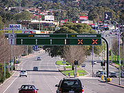
- The AnchietaRodovia AnchietaRodovia Anchieta is a highway connection between São Paulo and the Atlantic coast, the cities of Cubatão and Santos, in Brazil...
/ImigrantesRodovia dos ImigrantesRodovia dos Imigrantes is a highway in the state of São Paulo, Brazil.The highway connects the city of São Paulo to the Atlantic coast and with the seaside cities of São Vicente and Praia Grande. It follows the route of Rodovia Anchieta and is also one of Brazil's busiest highways, particularly on...
highway system in BrazilBrazilBrazil , officially the Federative Republic of Brazil , is the largest country in South America. It is the world's fifth largest country, both by geographical area and by population with over 192 million people...
contains the world's longest fully reversible road (The Imigrantes variant at a length of 58.5 km). It comprises a total of 10 lanes distributed over 4 separate roadways (3+3+2+2), each of which can be reversed. Traffic flow is unidirectional on up to three roadways at a time, in different combinations, depending on demand. Since this highway system is the only quick route from São PauloSão PauloSão Paulo is the largest city in Brazil, the largest city in the southern hemisphere and South America, and the world's seventh largest city by population. The metropolis is anchor to the São Paulo metropolitan area, ranked as the second-most populous metropolitan area in the Americas and among...
to the beach, the majority of the traffic on Fridays and Sundays are cars on weekend trips, creating highly asymmetrical demand. - The Southern ExpresswaySouthern ExpresswayThe Southern Expressway is the world's longest reversible one way freeway. Originally proposed as 'Noarlunga Freeway', it was built as a corridor to relieve heavy traffic from the major arterial, Main South Road, in Adelaide's south. The expressway was built in two stages — the first...
in AdelaideAdelaideAdelaide is the capital city of South Australia and the fifth-largest city in Australia. Adelaide has an estimated population of more than 1.2 million...
, South AustraliaSouth AustraliaSouth Australia is a state of Australia in the southern central part of the country. It covers some of the most arid parts of the continent; with a total land area of , it is the fourth largest of Australia's six states and two territories.South Australia shares borders with all of the mainland...
is the world's longest exclusively one-way reversible road, spanning 21 km though the city's southern suburbs. It changes direction to carry peak hour traffic to the city centre in the morning and away from the city in the evening. On weekends the directions are reversed. - In Washington, D.C.Washington, D.C.Washington, D.C., formally the District of Columbia and commonly referred to as Washington, "the District", or simply D.C., is the capital of the United States. On July 16, 1790, the United States Congress approved the creation of a permanent national capital as permitted by the U.S. Constitution....
, the Rock Creek and Potomac ParkwayRock Creek and Potomac ParkwayThe Rock Creek and Potomac Parkway, often known simply as the Rock Creek Parkway, is a parkway maintained by the National Park Service as part of Rock Creek Park in Washington, D.C...
between the Lincoln MemorialLincoln MemorialThe Lincoln Memorial is an American memorial built to honor the 16th President of the United States, Abraham Lincoln. It is located on the National Mall in Washington, D.C. The architect was Henry Bacon, the sculptor of the main statue was Daniel Chester French, and the painter of the interior...
and Calvert St. is converted from two lanes in each direction to one-way southbound in the morning and one-way northbound in the evening rush hour Monday through Friday, excluding federal holidays. The P Street exit, usually unavailable northbound, is an allowed left exit in the evening. South of Virginia Avenue, two lanes are closed during rush hours to facilitate the merge to or from Virginia Avenue. There are no overhead markings, but police barricades block wrong-way entrances to the roadway. - In Washington, D.C.Washington, D.C.Washington, D.C., formally the District of Columbia and commonly referred to as Washington, "the District", or simply D.C., is the capital of the United States. On July 16, 1790, the United States Congress approved the creation of a permanent national capital as permitted by the U.S. Constitution....
, parts of 15th Street NW and 17th Street NW are one-way during certain hours. There are no overhead markings on either road. - Canal Road in Washington, D.C. (between Foxhall Road and Arizona Avenue)
- Sherman Access in Hamilton, OntarioHamilton, OntarioHamilton is a port city in the Canadian province of Ontario. Conceived by George Hamilton when he purchased the Durand farm shortly after the War of 1812, Hamilton has become the centre of a densely populated and industrialized region at the west end of Lake Ontario known as the Golden Horseshoe...
. 2 lanes total, both marked as reversible, with both lanes flowing in the same direction during rush hour each weekday. - Assembly Street and Bluff Road (both part of South Carolina 48), along with Shop Road and George Rogers Blvd, in Columbia, South Carolina, are one-way during gridiron football matches at Williams-Brice StadiumWilliams-Brice StadiumWilliams-Brice Stadium is the home football stadium for the South Carolina Gamecocks, the college football team representing the University of South Carolina in Columbia, South Carolina...
/ - The lower deck of the Centre Street BridgeCentre Street Bridge (Calgary)The Centre Street Bridge is a bridge in Calgary, Alberta, crossing the Bow River, along the Centre Street. The lower deck connects Riverfront Avenue in Chinatown with Memorial Drive, while the upper elevated deck crosses Memorial Drive as well, reaching into the community of Crescent...
in CalgaryCalgaryCalgary is a city in the Province of Alberta, Canada. It is located in the south of the province, in an area of foothills and prairie, approximately east of the front ranges of the Canadian Rockies...
, AlbertaAlbertaAlberta is a province of Canada. It had an estimated population of 3.7 million in 2010 making it the most populous of Canada's three prairie provinces...
is fully reversible. It normally allows for two way traffic, but both lanes flow in the same direction during rush hour each day. - Victoria BridgeVictoria Bridge (Montreal)Victoria Bridge , formerly originally known as Victoria Jubilee Bridge, is a bridge over the St. Lawrence River, linking Montreal, Quebec, to the south shore city of Saint-Lambert....
, in MontrealMontrealMontreal is a city in Canada. It is the largest city in the province of Quebec, the second-largest city in Canada and the seventh largest in North America...
, QuebecQuebecQuebec or is a province in east-central Canada. It is the only Canadian province with a predominantly French-speaking population and the only one whose sole official language is French at the provincial level....
, normally allows for two-way traffic. But during rush hours, it only allows one-way traffic, northbound in the morning, and southbound in the afternoon. - Farnam Street in OmahaOmaha, NebraskaOmaha is the largest city in the state of Nebraska, United States, and is the county seat of Douglas County. It is located in the Midwestern United States on the Missouri River, about 20 miles north of the mouth of the Platte River...
is a normally two-way, two-lane street that during rush hour becomes one-way eastbound in the morning and westbound in the evening. - Sierichstraße in Hamburg, GermanyHamburg-History:The first historic name for the city was, according to Claudius Ptolemy's reports, Treva.But the city takes its modern name, Hamburg, from the first permanent building on the site, a castle whose construction was ordered by the Emperor Charlemagne in AD 808...
, a fully reversible, two-lane city street. - The 4th Street Bridge in Los AngelesLos ÁngelesLos Ángeles is the capital of the province of Biobío, in the commune of the same name, in Region VIII , in the center-south of Chile. It is located between the Laja and Biobío rivers. The population is 123,445 inhabitants...
, a fully reversible street controlled by overhead signals. It switches direction every rush hour and on weekends. In case of emergencies, the bridge can be one-way to or from Los Angeles. - The White Nile Bridge connecting KhartoumKhartoumKhartoum is the capital and largest city of Sudan and of Khartoum State. It is located at the confluence of the White Nile flowing north from Lake Victoria, and the Blue Nile flowing west from Ethiopia. The location where the two Niles meet is known as "al-Mogran"...
, SudanSudanSudan , officially the Republic of the Sudan , is a country in North Africa, sometimes considered part of the Middle East politically. It is bordered by Egypt to the north, the Red Sea to the northeast, Eritrea and Ethiopia to the east, South Sudan to the south, the Central African Republic to the...
and OmdurmanOmdurmanOmdurman is the second largest city in Sudan and Khartoum State, lying on the western banks of the River Nile, opposite the capital, Khartoum. Omdurman has a population of 2,395,159 and is the national centre of commerce...
, with 4 lanes total. Traffic is generally directed equally, 2 lanes to Khartoum and to lanes from except in the morning, where it's 3 lanes towards Khartoum, and in the evening, 3 lanes towards Omdurman.