
Vantage, Washington
Encyclopedia
Vantage is a census-designated place
(CDP) in Kittitas County, Washington, United States
. The population was 70 at the 2000 census.
Native Americans since prehistory. A number of well-preserved rock-paintings
have been found on the cliff walls. They also used the abundant petrified wood in the area for arrowheads and other tools. The site where these petroglyphs were found was inundated by the rising waters behind Wanapum Dam
in the 1960s. About 60 of the more than 300 carvings were cut from the basalt cliff face and saved. The site is one of the most unusual fossil forests in the world, and was designated a National Natural Landmark
by the National Park Service in 1965.
In the early part of the 20th century, residents in nearby Ellensburg
needed a more direct route when traveling east. So in 1914 a car ferry
was established to carry traffic across the Columbia River
at Vantage. This ferry was really just a small barge with wooden ramps at either end, and could carry only two cars at a time across the river. After several cars (some with occupants still in them) were lost overboard from the tiny ferry, the State Highway Department decided to construct a bridge over the Columbia.
In 1927, the 1640-foot bridge was opened at Vantage. This was an important link in the Sunset Highway, the major east-west thoroughfare in Washington state at the time(now I-90). The construction of the bridge required workers to enter pressurized Caissons 70 feet under the riverbed via airlock
s. Some workers became seriously ill from the effects of the pressure. Once completed, the bridge had a 70-foot clearance on the center span, allowing for river traffic to pass under the bridge.
This cantilever bridge served until 1962, when it was replaced with the current bridge. The original bridge was dismantled, and moved to the crossing at Lyons Ferry
, where it still stands today as the oldest extant steel cantilever bridge in Washington, and is listed in the National Register of Historic Places
.
With completion of the Wanapum Dam in the early 1960s, the townsite was relocated further up the hill above the rising water to the current location.
.
According to the United States Census Bureau
, the CDP has a total area of 0.3 square miles (0.8 km²), all of it land.
The original town of Vantage was flooded by the Columbia River when the Wanapum Dam was placed into operation.
of 2000, there were 70 people, 25 households, and 20 families residing in the CDP. The population density
was 219.7 people per square mile (84.5/km²). There were 39 housing units at an average density of 122.4/sq mi (47.1/km²). The racial makeup of the CDP was 22.86% White, 1.43% Pacific Islander, 2.86% from other races
, and 11.43% from two or more races. Hispanic or Latino of any race were 84.29% of the population. Besides these populations, approximately 2000 agricultural workers live in the Vantage area, and approximately 72.8% of are migratory.
There were 25 households out of which 28.0% had children under the age of 18 living with them, 68.0% were married couples
living together, 4.0% had a female householder with no husband present, and 20.0% were non-families. 20.0% of all households were made up of individuals and none had someone living alone who was 65 years of age or older. The average household size was 2.80 and the average family size was 3.25.
In the CDP the population was spread out with 24.3% under the age of 18, 15.7% from 18 to 24, 21.4% from 25 to 44, 32.9% from 45 to 64, and 5.7% who were 65 years of age or older. The median age was 36 years. For every 100 females there were 105.9 males. For every 100 females age 18 and over, there were 103.8 males.
The median income for a household in the CDP was $26,250, and the median income for a family was $43,750. Males had a median income of $26,250 versus $0 for females. The per capita income
for the CDP was $17,605.
There are several gas stations, two restaurants, and a private RV park/campground in Vantage. The Wild Horse Wind Farm
, owned by Puget Sound Energy
, is located on ridge tops near Vantage.
Recreation:
Vantage is known for Ginkgo/Wanapum State Park
, as a base camp for those attending nearby Gorge Amphitheatre
, and its rock climbing
,
The rock climbing in the area is one of the areas more popular forms of outdoor recreation and takes place, predominantly, in “Echo Basin” (often mistaken for “Frenchman Coulee” which is the basin just north of Echo, on the other side of the Old Vantage Hwy) on the basalt columns typical to the desert rimrock in the area.
Climbers started visiting the area as early as the 1950’s and 60’s but it wasn’t until the 80’s that the area really got “discovered” and was publicized; with that of course came an exponential increase in route development. Today the area holds over 400 established routes (both traditionally protected and bolted) ranging in difficulty from 5.0-.13c, and sees visitors almost year round.
Census-designated place
A census-designated place is a concentration of population identified by the United States Census Bureau for statistical purposes. CDPs are delineated for each decennial census as the statistical counterparts of incorporated places such as cities, towns and villages...
(CDP) in Kittitas County, Washington, United States
United States
The United States of America is a federal constitutional republic comprising fifty states and a federal district...
. The population was 70 at the 2000 census.
History
The area around Vantage has been occupied by the WanapumWanapum
The Wanapum tribe of Native Americans formerly lived along the Columbia River from above Priest Rapids down to the mouth of the Snake River in what is now the U.S. state of Washington. About 60 Wanapum still live near the present day site of Priest Rapids Dam...
Native Americans since prehistory. A number of well-preserved rock-paintings
Rock art
Rock art is a term used in archaeology for any human-made markings made on natural stone. They can be divided into:*Petroglyphs - carvings into stone surfaces*Pictographs - rock and cave paintings...
have been found on the cliff walls. They also used the abundant petrified wood in the area for arrowheads and other tools. The site where these petroglyphs were found was inundated by the rising waters behind Wanapum Dam
Wanapum Dam
Wanapum Dam is a hydroelectric project located on the Columbia River downstream from Vantage, Washington where Interstate 90 crosses the Columbia from Grant County into Kittitas County. It is owned by the Grant County Public Utility District. Its reservoir is named Lake Wanapum.The dam, and its...
in the 1960s. About 60 of the more than 300 carvings were cut from the basalt cliff face and saved. The site is one of the most unusual fossil forests in the world, and was designated a National Natural Landmark
Ginkgo/Wanapum State Park
Ginkgo Petrified Forest State Park/Wanapum Recreational Area is a state park at Vantage, Washington including 27,000 feet of freshwater shoreline on the Wanapum Reservoir on the Columbia River. Petrified wood was discovered in the region in the early 1930s, which led to creation of the park...
by the National Park Service in 1965.
In the early part of the 20th century, residents in nearby Ellensburg
Ellensburg, Washington
Ellensburg is a city in, and the county seat of, Kittitas County, Washington, United States. The population was 18,174 at the 2010 census. The population was 18,250 at 2011 Estimate from Office of Financial Management. Ellensburg is located just east of the Cascade Range on I-90 and is known as the...
needed a more direct route when traveling east. So in 1914 a car ferry
Ferry
A ferry is a form of transportation, usually a boat, but sometimes a ship, used to carry primarily passengers, and sometimes vehicles and cargo as well, across a body of water. Most ferries operate on regular, frequent, return services...
was established to carry traffic across the Columbia River
Columbia River
The Columbia River is the largest river in the Pacific Northwest region of North America. The river rises in the Rocky Mountains of British Columbia, Canada, flows northwest and then south into the U.S. state of Washington, then turns west to form most of the border between Washington and the state...
at Vantage. This ferry was really just a small barge with wooden ramps at either end, and could carry only two cars at a time across the river. After several cars (some with occupants still in them) were lost overboard from the tiny ferry, the State Highway Department decided to construct a bridge over the Columbia.
In 1927, the 1640-foot bridge was opened at Vantage. This was an important link in the Sunset Highway, the major east-west thoroughfare in Washington state at the time(now I-90). The construction of the bridge required workers to enter pressurized Caissons 70 feet under the riverbed via airlock
Airlock
An airlock is a device which permits the passage of people and objects between a pressure vessel and its surroundings while minimizing the change of pressure in the vessel and loss of air from it...
s. Some workers became seriously ill from the effects of the pressure. Once completed, the bridge had a 70-foot clearance on the center span, allowing for river traffic to pass under the bridge.
This cantilever bridge served until 1962, when it was replaced with the current bridge. The original bridge was dismantled, and moved to the crossing at Lyons Ferry
Snake River Bridge
The Snake River Bridge , located on State Route 261 at the confluence of the Snake and Palouse Rivers, near Starbuck, Washington, USA, is the oldest extant steel cantilever bridge in Washington...
, where it still stands today as the oldest extant steel cantilever bridge in Washington, and is listed in the National Register of Historic Places
National Register of Historic Places
The National Register of Historic Places is the United States government's official list of districts, sites, buildings, structures, and objects deemed worthy of preservation...
.
With completion of the Wanapum Dam in the early 1960s, the townsite was relocated further up the hill above the rising water to the current location.
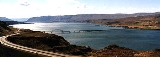
Geography
Vantage is located at 46°56′48"N 119°59′30"W (46.946710, -119.991758) along the Columbia RiverColumbia River
The Columbia River is the largest river in the Pacific Northwest region of North America. The river rises in the Rocky Mountains of British Columbia, Canada, flows northwest and then south into the U.S. state of Washington, then turns west to form most of the border between Washington and the state...
.
According to the United States Census Bureau
United States Census Bureau
The United States Census Bureau is the government agency that is responsible for the United States Census. It also gathers other national demographic and economic data...
, the CDP has a total area of 0.3 square miles (0.8 km²), all of it land.
The original town of Vantage was flooded by the Columbia River when the Wanapum Dam was placed into operation.
Demographics
As of the censusCensus
A census is the procedure of systematically acquiring and recording information about the members of a given population. It is a regularly occurring and official count of a particular population. The term is used mostly in connection with national population and housing censuses; other common...
of 2000, there were 70 people, 25 households, and 20 families residing in the CDP. The population density
Population density
Population density is a measurement of population per unit area or unit volume. It is frequently applied to living organisms, and particularly to humans...
was 219.7 people per square mile (84.5/km²). There were 39 housing units at an average density of 122.4/sq mi (47.1/km²). The racial makeup of the CDP was 22.86% White, 1.43% Pacific Islander, 2.86% from other races
Race (United States Census)
Race and ethnicity in the United States Census, as defined by the Federal Office of Management and Budget and the United States Census Bureau, are self-identification data items in which residents choose the race or races with which they most closely identify, and indicate whether or not they are...
, and 11.43% from two or more races. Hispanic or Latino of any race were 84.29% of the population. Besides these populations, approximately 2000 agricultural workers live in the Vantage area, and approximately 72.8% of are migratory.
There were 25 households out of which 28.0% had children under the age of 18 living with them, 68.0% were married couples
Marriage
Marriage is a social union or legal contract between people that creates kinship. It is an institution in which interpersonal relationships, usually intimate and sexual, are acknowledged in a variety of ways, depending on the culture or subculture in which it is found...
living together, 4.0% had a female householder with no husband present, and 20.0% were non-families. 20.0% of all households were made up of individuals and none had someone living alone who was 65 years of age or older. The average household size was 2.80 and the average family size was 3.25.
In the CDP the population was spread out with 24.3% under the age of 18, 15.7% from 18 to 24, 21.4% from 25 to 44, 32.9% from 45 to 64, and 5.7% who were 65 years of age or older. The median age was 36 years. For every 100 females there were 105.9 males. For every 100 females age 18 and over, there were 103.8 males.
The median income for a household in the CDP was $26,250, and the median income for a family was $43,750. Males had a median income of $26,250 versus $0 for females. The per capita income
Per capita income
Per capita income or income per person is a measure of mean income within an economic aggregate, such as a country or city. It is calculated by taking a measure of all sources of income in the aggregate and dividing it by the total population...
for the CDP was $17,605.
Business and recreation
Business:There are several gas stations, two restaurants, and a private RV park/campground in Vantage. The Wild Horse Wind Farm
Wild Horse Wind Farm
The Wild Horse Wind Farm is a 229-megawatt wind farm that generates energy for Puget Sound Energy that consists of one hundred twenty-seven 1.8-megawatt Vestas V80 turbines on a site in Kittitas County, Washington, east of Ellensburg, Washington....
, owned by Puget Sound Energy
Puget Sound Energy
Puget Sound Energy is Washington state's oldest local energy utility providing electrical power and natural gas in the Puget Sound region of the northwest United States...
, is located on ridge tops near Vantage.
Recreation:
Vantage is known for Ginkgo/Wanapum State Park
Ginkgo/Wanapum State Park
Ginkgo Petrified Forest State Park/Wanapum Recreational Area is a state park at Vantage, Washington including 27,000 feet of freshwater shoreline on the Wanapum Reservoir on the Columbia River. Petrified wood was discovered in the region in the early 1930s, which led to creation of the park...
, as a base camp for those attending nearby Gorge Amphitheatre
The Gorge Amphitheatre
The Gorge Amphitheatre is a 20,000+ seat concert venue, located above the Columbia River in George, Washington. It offers lawn-terrace seating and concert-friendly weather....
, and its rock climbing
Rock climbing
Rock climbing also lightly called 'The Gravity Game', is a sport in which participants climb up, down or across natural rock formations or artificial rock walls. The goal is to reach the summit of a formation or the endpoint of a pre-defined route without falling...
,
The rock climbing in the area is one of the areas more popular forms of outdoor recreation and takes place, predominantly, in “Echo Basin” (often mistaken for “Frenchman Coulee” which is the basin just north of Echo, on the other side of the Old Vantage Hwy) on the basalt columns typical to the desert rimrock in the area.
Climbers started visiting the area as early as the 1950’s and 60’s but it wasn’t until the 80’s that the area really got “discovered” and was publicized; with that of course came an exponential increase in route development. Today the area holds over 400 established routes (both traditionally protected and bolted) ranging in difficulty from 5.0-.13c, and sees visitors almost year round.