
Interstate 69 in Indiana
Encyclopedia
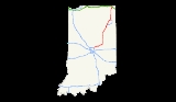
Interstate 69 presently exists in two discontinuous segments in Indiana
. The original 157.3 miles (253.1 km) highway, completed in November 1971, runs northeast from the state capital of Indianapolis
, to the city of Fort Wayne
, and then proceeds north to the state of Michigan
(eventually reaching its capital city, Lansing
and beyond). A new 1.73 miles (2.8 km) segment in Southwest Indiana, opened in September 2009, starts at the I-64
/I-164
interchange in Gibson County
just north of Evansville
and ends at Indiana State Road 68
(SR 68) southeast of Princeton
. This is the first Indiana section completed of the planned national extension of I-69 southwest from Indianapolis via Memphis, Tennessee
to the international border with Mexico
in Texas
.
, the Indianapolis
outer beltway, where Binford Boulevard, a four-lane divided surface arterial that formerly carried SR 37
transitions into the I-69 freeway. Southbound at this junction, most I-69 motorists take exit 0 to remain on a freeway and reach either I-465 south (with SR 37 south and the future extended I-69) or I-465 west. Running in a northeasterly direction and concurrent
with SR 37, I-69 turns east-northeast at the end of that overlap just past mile marker 5 in Fishers
. From there, the freeway turns more easterly at the Greenfield Road (former SR 238
) interchange until it reaches the Pendleton
area.
After bypassing Pendleton to the west and north, SR 9
and SR 67
join I-69, which continues to the east-northeast into the Anderson
area. There, SR 9 departs, and shortly thereafter I-69 begins two long curves to the northeast, and then the north. Between Daleville
and Chesterfield
, SR 67 departs I-69, bound for Muncie
. From the Anderson–Muncie region, I-69 continues north, running concurrently with US 35 between SR 28
east of Alexandria
and SR 22
near Gas City
. After passing SR 18
east of Marion
, I-69 then heads more northeast, straight toward the Fort Wayne
metro area.
At the south junction of I-469
, located at Lafayette Center Road near the General Motors
truck assembly plant, US 24
and US 33
join I-69. US 24 remains cosigned with I-69 to the interchange at Jefferson Boulevard (originally known as Upper Huntington Road), even though it takes travelers on that route several miles out of their way. US 33 continues on north to the Goshen Road
interchange near Coliseum Boulevard on the northwest side of Fort Wayne, where it departs I-69, US 30
joins, and the freeway curves more to the east once again. The next junction is the US 27
/SR 3
interchange at Lima Road on the north side of Fort Wayne. From the mid-1960s to 2001, US 27 was rerouted onto a concurrency with I-69 from here north to the Michigan border, but the former route has since been truncated to this point. Past the next interchange at Coldwater Road, the original routing of US 27 north of town, the freeway curves back to a northerly heading. At the north junction of I-469, US 30 departs to the east and shortly thereafter I-69 leaves the Fort Wayne metro area.
I-69 then continues north, passing just to the west of Auburn
, Waterloo
, and Angola
, before reaching the I-80/90 Indiana East–West Toll Road
near Fremont
. Shortly thereafter, the route crosses into Michigan
at a point just northeast of Jamestown, Indiana
.
The portion of I-69 between Indianapolis and the Toll Road was first proposed in the seminal report Interregional Highways, released in January 1944. By March 1946, it was formally made part of the new National System of Interstate Highways by the U.S. Public Roads Administration. In 1958, its first extension was approved. This took the route into Michigan in order to connect with I-94
near Marshall
. It was extended yet again, north to Lansing
in the 1960s, and then east—first to Flint
and finally to the border with Canada
at Port Huron, Michigan
—in the 1980s. The extreme southern portion of I-69 from I-465 to central Indianapolis was never built, though unpaved ghost ramps and overpasses for its connection to I-65
and I-70
can still be seen at the North Split/Spaghetti Bowl
interchange just northeast of downtown Indy.
Until recent years, all of I-69 in Indiana north of the Indianapolis metro area was four lanes, but INDOT has reconstructed and widened I-69 to six lanes through most of Fort Wayne. Likewise, INDOT has widened I-69 from I-465 on the northeast side of Indianapolis to SR 37 in Fishers from the original six lanes to seven and eight lanes during the first decade of the 2000s. A complete rebuild of most of this highly congested segment is hoped to be completed by 2015, with project plans calling for a total of 14 lanes (eight for the mainline and six in parallel collector-distributor lanes).
near mile marker 50. Totally rebuilt in 2008, these areas also serve motorists on US 35, which is concurrent with I-69 along this stretch of freeway. Near mile marker 80 in Huntington County
, there were originally twin weigh stations for commercial vehicles; however, only the southbound facility is still used. The Flat Creek Rest Area serves those heading north near mile marker 89, also in Huntington County. Its southbound companion a couple miles to the north in Wells County
(just south of the Wells–Allen
county line near mile marker 92) was permanently closed in January 2009 due to its age, cost of maintenance and operation, as well as its relative proximity to the city of Fort Wayne
. Two other rest areas just north of that city in DeKalb County
were also closed by 2001 for similar reasons. There the twin Cedar Creek Rest Areas once served northbound and southbound traffic near mile marker 123. In July 2011 it was reported that INDOT has begun building a new northbound facility at the site, scheduled to open in November 2012. Until then, between Fort Wayne and the Michigan state line only one rest area remains open, the Pigeon Creek Welcome Center serving southbound motorists in Steuben County
near mile marker 145.
. Preliminary routing of the highway from SR 38
near Pendleton
to Indianapolis had it generally following the SR 67
corridor southwest, joining I-70
near German Church Road on the east side of Marion County
, where the two routes would then be cosigned into the city. Later route location studies in 1961 recommended a different path, heading generally west from Pendleton to SR 37
near Fishers
, then southwest past the Indianapolis outer beltway concurrent with the new location of that state route. Once well into the city, it would turn south to cross Fall Creek
and meet up with the inner loop at its northeast corner. In fact, the grading and overpasses for this never-built connection's ramps can still be seen at that location.
However, in 1962 the U.S. Bureau of Public Roads (BPR) ruled that it would only approve funding for I-69 to be built to the first Interstate highway connection in the Indianapolis area, which was the I-465
outer beltway near Castleton
. State officials later sought to designate the proposed Northeast Freeway connecting that I-69/I-465 interchange to the North Split interchange, approximately 11 miles (18 km) in length, as Interstate 165 in order to get around the initial ruling. But after a political fight over the inner-city
portions of I-70 and I-65
(part of the national freeway revolt), it was eventually decided in the late 1970s to scrap the Northeast Freeway altogether. In its place, the state was allowed to use Federal funds to widen I-70 from its original six lanes to eight and ten lanes as well as to rework its east side interchange with I-465 in order to handle the additional traffic loads from I-69 and the northeastern suburbs it serves.
, then east to Port Huron, Michigan
. It was built in stages between 1956 and 1992, with the final gap between Charlotte, Michigan
, and Lansing being closed on October 22, 1992. When the national I-69 extension project was conceived, SIU 1 was already long completed, so all future work in this segment of the "new I-69" would be limited to mainline upgrades and operational improvements.
A major project in the Fort Wayne
metro area began in 2002, resulting in an additional travel lane in each direction, bridge and pavement reconstruction, and interchange reconfiguration. Plans for SIU 1 also included spot improvements and pavement rehabilitation to the I-469
loop around Fort Wayne and additional mainline and interchange improvements to I-69 northeast of Indianapolis.
to Bloomington, Indiana
, where a new terrain routing to the southwest will serve the Crane NSWC
, Washington
, and Oakland City, Indiana
. The route will then intersect I-64
(where SIU 3 ends) and encompass most of existing I-164
through the Evansville, Indiana, area, crossing the Ohio River
a few miles upstream of the existing US 41
bridges (SIU 4) near its confluence with the Green River
.
(INDOT) has been highly methodical in its analysis and mitigation of the potential environmental impacts
associated with the planned I-69 extension through southwest Indiana. As such INDOT has taken a two-tier approach to completing the environmental documentation required for construction to proceed. During the Tier 1 studies, 14 route alternatives were analyzed and compared against the "No-Build" option. Of these alternatives, nine were eliminated from consideration as either having too great of an impact on the natural and human environment, failing to achieve the stated goals established for the I-69 extension, or both. The five alternatives that remained were as follows:
Alternative 1 ran from US 41 to Terre Haute
and along I-70
from Terre Haute to Indianapolis. This alternative was favored heavily by Terre Haute. Alternative 2 used US 41 to Vincennes
and SR 67
from Vincennes to Indianapolis; it was favored by Princeton
and Vincennes. Alternative 3 was one of the two mostly overland routes along SR 57
crossing cross country to SR 37 near Bloomington and using SR 37 to Indianapolis. This proposal was largely Supported by the Evansville area but significantly opposed by Bloomington. A modified version of Alternative 3 is the current path of I-69's construction.
Alternative 4 followed SR 57 to US 231
near Bloomfield
and US 231 from there to Spencer
. Next it went cross country to Martinsville, followed SR 37 from Martinsville to Indianapolis, or continuing north to I-70; I-70 to Indianapolis. This concept had more support from the "Hoosier Hills Area. Alternative 5 was the last studied and used SR 57 to US 50 bypass just south of Washington
. Afterwards, it followed US 50 eastward through Daviess
and Martin
counties to SR 37 just east of Bedford
and then SR 37 from Bedford to Indianapolis. This alternative was favored mainly by Bedford.
In 2003, INDOT presented the Tier 1 EIS to the Federal Highway Administration, which identified Alternative 3C (following SR 37 between Indianapolis and Bloomington, then over new terrain to US 231 north of Crane Naval Surface Warfare Center, then following SR 57 south-southwest to the I-64/I-164 interchange northeast of Evansville) as the least environmentally damaging practical alternative. Subsequently in March 2003 the FHWA issued a Record of Decision approving the Tier 1 EIS for SIU 3.
near Oakland City
. Officials further noted that they will accelerate the final EIS and construction on the southernmost 2 miles (3 km) section from I-64 to SR 68
to facilitate access to the Toyota's
Princeton plant. On April 30, Governor Daniels signed the state's two-year $26 billion budget, which includes $119 million to fund construction of the southernmost segment of I-69, ensuring that construction began as scheduled in the summer of 2008. The Final EIS for the southernmost section was issued on October 22, 2007.
On October 3, 2006, protest groups, citing environmental concerns, along with six individuals who live along the I-69 corridor, filed a lawsuit in federal court, alleging that state and federal agencies "rigged" environmental studies and violated several federal laws in the selection of a new-terrain route for I-69. They further pressed the court for a summary ruling directing the FHWA and INDOT to route I-69 over I-70 and US 41. Judge David Hamilton
disagreed, and on December 10, 2007, he issued a 58-page ruling upholding the selected route for I-69 and the Tier 1 ROD. His ruling did however, leave open the possibility that the FHWA and INDOT may be forced to reconsider some or all of the previously-rejected Tier 1 alternatives if there are new significant findings during the Tier 2 studies that were absent from the Tier 1 EIS. Barring any new major findings in the Tier 2 studies, Judge Hamilton's ruling paved the way for construction to begin on the southernmost segment.
These small protest groups have sworn to do everything possible to stop its construction. Especially active is a group called Roadblock Earth First which has been responsible for a number of incidents in Oakland City and at a Haubstadt
asphalt yard given the contract for the first segment.
On February 10, 2008, INDOT and the FHWA issued the Tier 2 Draft EIS for two sections from Oakland City to Crane, totaling 55 miles (88.5 km). Of the changes to the original alternative, the DEIS extends the bridge over the Patoka River from 500 to 4400 ft (152.4 to 1,341.1 m) to minimize damage to the river and adjacent wetlands. Construction on two rural interchanges would be postponed to free up $30 million for the extended bridge. INDOT released the 5,000-page Tier 2 FEIS for Section 3 from US 50 in Washington to US 231 near Crane on December 10, 2009. The ROD for Section 3 was issued in March 2010 and construction began in April 2010. The ROD for Section 2 (Oakland City to Washington) was issued in May 2010. In May 2010, Governor Daniels announced plans for I-69 to be open from I-64 to Bloomington by 2014 (Sections 1 through 4).
, on February 6, 2008. This contract, completed on May 31, 2008, included the removal of buildings and vegetation from the I-69 right-of-way between I-64 and SR 68. Gohmann also won the construction contract for the first two miles (3.2 km) from I-64 to SR 68 with a $25 million bid. Construction began with a groundbreaking ceremony in Evansville on July 16, 2008. INDOT built this first section of the extension of I-69 using the design-build
method. Crews had completed most of the utilities relocation work and earthworks for I-69 between I-64 and SR 68 by September 6, 2008.
directed traffic through the new I-69 segment until crews could install additional signage to more clearly mark the new route. The former SR 57 roadway between SR-68 and I-64 was closed off with a cul de sac and now serves as a local access road.
While the new section of I-69 continues the I-164 exit numbering (its mileage roughly coincides with that for future I-69, depending on the exact alignment of the Ohio River Bridge and its connection to I-164 in SIU 4), it is signed as I-69 and not as a northward extension of I-164.
lease to be used to complete nearly 20 years of environmental studies and construct about half of the proposed extension (between the I-64/164 interchange and the Crane Naval Surface Warfare Center). It also allowed for the construction of 117 miles (188 km) of the 142 miles (229 km) I-69 extension to Evansville to be constructed as the Southern Indiana Toll Road
. Due to ongoing controversy over making this portion of the extension a toll-road, the governor announced in November 2006 that the entire stretch of the highway would be toll-free, subject to construction of the Indiana Commerce Connector (SIU 2). Officials with the INDOT have since stated that I-69 will be toll-free regardless of whether or not the Indiana Commerce Connector is constructed. Additionally, the U.S. Congress
allocated an additional $14 million in the 2005 SAFETEA-LU authorization to construct I-69 Evansville to Indianapolis. When SIU 3 and the Indiana portion of SIU 4 are completed, I-69 will be approximately 340 miles (547 km) in Indiana.
(INDOT) petitioned the Federal Highway Administration
(FHWA) and the American Association of State Highway and Transportation Officials
(AASHTO) to change the designation of the I-69 extension from "Proposed Route 69" to "Interstate 69", citing that 2 miles (3.2 km) of the extension is already open to traffic, and a total of 107 miles (172.2 km) out of 183 miles (294.5 km) from the southern terminus of the original I-69 to the Ohio River
near Evansville will be open by the end of 2012. Such a move would allow INDOT to erect I-69 signs on I-465 and reset reference posts (RP) and renumber exits on the original section north of Indianapolis (starting with RP 184 instead of the current RP 0).
beltway around Indianapolis, using the east and south legs of I-465 to a point at or just west of the SR 37
/Harding Street interchange on the southwest side of the Circle City. Much of this stretch of I-465 was reconstructed during the first decade of the 2000s, with additional improvements scheduled for the 2010s, totally independent of the I-69 extension project.
There's also been some speculation of a route through the heart of Indianapolis, along the Binford Boulevard (old SR 37) and Fall Creek Parkway corridors to downtown, which ironically, was the original intended alignment for I-69 within the city. However, no official route has been determined at this time.
On November 9, 2006, Governor Mitch Daniels
announced plans for a 75 miles (121 km) outer loop around Indianapolis to be known as the Indiana Commerce Corridor (ICC). As proposed, that route would have been 100% privately funded, with a portion of the revenues possibly applied to constructing I-69 from Indianapolis to the Crane Naval Surface Warfare Center (NSWC). The remaining portion of the highway to Evansville, Indiana
, was already funded with funds from the Major Moves
initiative. Strong opposition from local residents and the then-Democrat-controlled House of Representatives
forced Governor Daniels to abandon the ICC plan on March 24, 2007, although House Democrats assured southwest Indiana residents that this decision would not affect construction on I-69 between Indianapolis and the Crane NSWC.
On October 24, 2007, INDOT announced a $600 million plan to reconstruct the I-69/I-465 interchange on the northeast side of Indianapolis, that includes widening about 8 miles (12.9 km) of I-69, I-465, and Binford Boulevard. Environmental studies and design work are currently underway, and construction on the I-69 portion of the project is expected to begin in 2012.
and Henderson, Kentucky
, near the mouth of the Green River. Once in Kentucky, I-69 will continue south on a new alignment and intersect the Audubon Parkway
before joining the Breathitt Parkway
about 3 miles (4.8 km) further south. The Final EIS is currently being prepared for this segment of I-69, but this portion of the route has not yet been funded. Construction of the new Ohio River crossing and new roadway on the Kentucky side is expected to cost approximately $800 million. Indiana and Kentucky officials have said construction on the new Ohio River Bridge will not begin until at least 2020, after two new crossings near Louisville
are completed. With Indiana then preparing to break ground on SIU 3, Kentucky officials indicated that collecting tolls might be the only feasible option for completing the I-69 bridge as traditional federal and state funding for such projects were drying up. To reflect this, Kentucky Senate Majority Leader David Williams (R-Burkesville) introduced Senate Bill 7 on January 25, 2007. As drafted, that bill would have established public authorities to oversee construction, maintenance and operations, and collect tolls on four new Ohio River crossings: the two Louisville bridges
(currently under construction), the I-69 bridge, and the Brent Spence Bridge
that carries I-71
and I-75
from Covington
to Cincinnati
. Senate Bill 7 had bipartisan support in both chambers of the Kentucky Legislature and by Governor Steve Beshear
. The bill also provided for state and local oversight, each having a seven-member board with four members appointed by the governor and three members from the local area. Senate Bill 7 ultimate died during the 2007 legislative session, and attempts at reviving the toll authority legislation subsequently failed in 2008. In 2009, toll authority legislation was re-introduced as House Bill 3, which failed to pass during the regular session, but passed both the House and Senate during a special session in June 2009. The bi-state toll authority legislation was signed into law by Governor Steve Beshear on July 15, 2009. However, Kentucky officials indicated that no bi-state authority for the I-69 bridge will be established until the Louisville bridges are completed.
communities accusing highway opponents further north of trying to isolate this region from the rest of the state by blocking construction of a direct highway link to Indianapolis. To the west, communities along US 41 favor the presently selected alignment in lieu of the only other feasible routing: I-70 to Terre Haute, then US 41 south to Evansville. Regardless of the I-69 routing, an Interstate-quality bypass is slated to be built east of Terre Haute, which preferred the I-70/US 41 routing over the selected routing of I-69 for purely local economic reasons.
INDOT, current and past governors, and businesses and elected officials in Evansville and adjacent southwest Indiana communities, have favored a direct route via Bloomington that would be built over new terrain from Bloomington to Evansville. Supporters argued that this direct route reduces the travel time to Indianapolis as well as improves access to Bloomington for residents of southwestern Indiana, something a route via Terre Haute would not achieve. INDOT officials have also pointed out that SR 37 will eventually be upgraded from a four-lane expressway to full freeway status, with or without I-69. After extensive review of the alternative routes as well as detailed environmental studies, the state selected the new terrain route via Bloomington.
Environmentalists claimed the construction of I-69 will lead to the destruction of 1500 acres (6.1 km²) of forest and more than 300 acres (1.2 km²) of wetlands. The route selected passes through the Patoka River National Wildlife Refuge
but on a corridor that the federal government purposely did not acquire for the refuge. This was because of an agreement with the state not to dispute the passage of a highway on this corridor. Environmental groups then filed suit in federal court
on October 2, 2006, to block further study and construction of the route, but this lawsuit was dismissed by U.S. District Judge David F. Hamilton on December 12, 2007, clearing the way for construction to begin in 2008. Opponents had considered appealing Judge Hamilton's ruling to the U.S. Court of Appeals for the Seventh Circuit
(which could have possibly sent the case to the Supreme Court of the United States
), but they ultimately abandoned further legal challenges to the proposed route. Instead, opponents tried to block construction through the legislative process, when Democrats in the Indiana House of Representatives stripped funding for the I-69 extension in their version of the 2008 two-year state budget. Money for I-69 was restored after budget negotiations with the Republican-controlled Indiana Senate.
Another area of controversy arose in late 2005 when governor Mitch Daniels
proposed levying tolls on the highway to finance its construction, either as a state project or a public-private partnership, in order to accelerate the project. As the route would overlay the existing SR 37 between Bloomington and Indianapolis, and there currently is no other free alternative route between Bloomington and Martinsville, this proposal has raised concerns among local residents and businesses. In March 2006, Daniels signed a bill known as "Major Moves
" that leased the Indiana East–West Toll Road
, but also included a compromise on constructing I-69 in southwest Indiana. As part of the deal, the legislation permitted the Governor to enter a similar public-private partnership for construction of 117 miles (188 km) of I-69 as the Southern Indiana Toll Road
from Martinsville to the I-64/I-164 interchange, while the remaining 25 miles (40 km) from Martinsville to the I-465/SR 37 interchange in Indianapolis would remain toll-free. On June 20, 2006, the Indiana Supreme Court rejected a legal challenge brought on by I-69 opponents, upholding Major Moves legislation in a 4–0 decision. The toll road option was highly unpopular, even among many who supported the extension via Bloomington. As a result Governor Daniels announced in December 2006 that I-69 through southwest Indiana would be toll-free.
. Especially active has been a group called Roadblock Earth First which has been responsible for a number of incidents in Oakland City
and at a Haubstadt
asphalt yard given the contract for the first segment. Like in Indianapolis, most of the protesters were from out-of-state; several were from California. In 2009, two protesters were arrested on charges of felony racketeering for standing on tables and shouting at public meetings in 2007 and 2008. A judge dismissed the federal racketeering charge in March 2010 and the defendants accepted a plea bargain for the remaining misdemeanor charges. These arrests were widely viewed among opponents of I-69 as an effort to intimidate critics, as were many SLAPP lawsuits
allegedly used to silence peaceful protesters but actually intended to recover losses caused by the protestors.
Indiana
Indiana is a US state, admitted to the United States as the 19th on December 11, 1816. It is located in the Midwestern United States and Great Lakes Region. With 6,483,802 residents, the state is ranked 15th in population and 16th in population density. Indiana is ranked 38th in land area and is...
. The original 157.3 miles (253.1 km) highway, completed in November 1971, runs northeast from the state capital of Indianapolis
Indianapolis, Indiana
Indianapolis is the capital of the U.S. state of Indiana, and the county seat of Marion County, Indiana. As of the 2010 United States Census, the city's population is 839,489. It is by far Indiana's largest city and, as of the 2010 U.S...
, to the city of Fort Wayne
Fort Wayne, Indiana
Fort Wayne is a city in the US state of Indiana and the county seat of Allen County. The population was 253,691 at the 2010 Census making it the 74th largest city in the United States and the second largest in Indiana...
, and then proceeds north to the state of Michigan
Michigan
Michigan is a U.S. state located in the Great Lakes Region of the United States of America. The name Michigan is the French form of the Ojibwa word mishigamaa, meaning "large water" or "large lake"....
(eventually reaching its capital city, Lansing
Lansing, Michigan
Lansing is the capital of the U.S. state of Michigan. It is located mostly in Ingham County, although small portions of the city extend into Eaton County. The 2010 Census places the city's population at 114,297, making it the fifth largest city in Michigan...
and beyond). A new 1.73 miles (2.8 km) segment in Southwest Indiana, opened in September 2009, starts at the I-64
Interstate 64
Interstate 64 is an Interstate Highway in the Midwestern and Southeastern United States. Its western terminus is at I-70, U.S. 40, and U.S. 61 in Wentzville, Missouri. Its eastern terminus is at an interchange with I-264 and I-664 at Bowers Hill in Chesapeake, Virginia. As I-64 is concurrent with...
/I-164
Interstate 164
Interstate 164 is a spur highway of Interstate 64 in Evansville, Indiana. Interstate 164, also known as the Robert D. Orr Highway, has a total length of...
interchange in Gibson County
Gibson County, Indiana
Gibson County is a county located in the southwestern part of the U.S. state of Indiana and is included in the Evansville, Indiana–Kentucky Metropolitan Statistical Area. As of 2010, the population was 33,503. The county seat is Princeton.-Geography:...
just north of Evansville
Evansville, Indiana
Evansville is the third-largest city in the U.S. state of Indiana and the largest city in Southern Indiana. As of the 2010 census, the city had a total population of 117,429. It is the county seat of Vanderburgh County and the regional hub for both Southwestern Indiana and the...
and ends at Indiana State Road 68
Indiana State Road 68
State Road 68 in the U.S. State of Indiana is a route in Gibson, Posey, Spencer and Warrick counties.-Route description:State Road 68 begins in New Harmony at State Road 69 and runs east, passing through the towns of Poseyville, Cynthiana, Haubstadt, Lynnville and Selvin...
(SR 68) southeast of Princeton
Princeton, Indiana
The median income for a household in the city was $26,689, and the median income for a family was $37,308. Males had a median income of $28,076 versus $19,825 for females. The per capita income for the city was $15,049...
. This is the first Indiana section completed of the planned national extension of I-69 southwest from Indianapolis via Memphis, Tennessee
Memphis, Tennessee
Memphis is a city in the southwestern corner of the U.S. state of Tennessee, and the county seat of Shelby County. The city is located on the 4th Chickasaw Bluff, south of the confluence of the Wolf and Mississippi rivers....
to the international border with Mexico
Mexico
The United Mexican States , commonly known as Mexico , is a federal constitutional republic in North America. It is bordered on the north by the United States; on the south and west by the Pacific Ocean; on the southeast by Guatemala, Belize, and the Caribbean Sea; and on the east by the Gulf of...
in Texas
Texas
Texas is the second largest U.S. state by both area and population, and the largest state by area in the contiguous United States.The name, based on the Caddo word "Tejas" meaning "friends" or "allies", was applied by the Spanish to the Caddo themselves and to the region of their settlement in...
.
Route description
The original stretch of I-69 in Indiana begins with an interchange at the northeast corner of I-465Interstate 465
Interstate 465 , also known as the USS Indianapolis Memorial Highway, is the beltway circling Indianapolis, Indiana, United States. It is roughly rectangular in shape and has a perimeter of approximately 53 miles . It lies almost completely within the boundaries of Marion County, except for two...
, the Indianapolis
Indianapolis, Indiana
Indianapolis is the capital of the U.S. state of Indiana, and the county seat of Marion County, Indiana. As of the 2010 United States Census, the city's population is 839,489. It is by far Indiana's largest city and, as of the 2010 U.S...
outer beltway, where Binford Boulevard, a four-lane divided surface arterial that formerly carried SR 37
Indiana State Road 37
State Road 37 in the U.S. State of Indiana is a major route in Indiana, running as a 4-lane divided highway for 110 miles of its course....
transitions into the I-69 freeway. Southbound at this junction, most I-69 motorists take exit 0 to remain on a freeway and reach either I-465 south (with SR 37 south and the future extended I-69) or I-465 west. Running in a northeasterly direction and concurrent
Concurrency (road)
A concurrency, overlap, or coincidence in a road network is an instance of one physical road bearing two or more different highway, motorway, or other route numbers...
with SR 37, I-69 turns east-northeast at the end of that overlap just past mile marker 5 in Fishers
Fishers, Indiana
Fishers is a town located in Fall Creek and Delaware townships, Hamilton County, Indiana, with a population of 76,794, according to the 2010 census. A suburb of Indianapolis, Fishers has grown rapidly in recent decades: about 350 people lived there in 1963, 2,000 in 1980, and only 7,200 as recently...
. From there, the freeway turns more easterly at the Greenfield Road (former SR 238
Indiana State Road 238
State Road 238 is a short stretch of two-lane undivided road, mostly in Hamilton County, that travels southeast from near Fishers to Fortville. The western portion was concurrent with Greenfield Avenue....
) interchange until it reaches the Pendleton
Pendleton, Indiana
Pendleton is a town in Fall Creek Township, Madison County, Indiana, United States. It is part of the Anderson, Indiana Metropolitan Statistical Area...
area.
After bypassing Pendleton to the west and north, SR 9
Indiana State Road 9
State Road 9 in the U.S. State of Indiana is a long north–south state highway in the eastern portion of Indiana. Its southern terminus is near Columbus at State Road 46, and the northern terminus is at the Michigan/Indiana border between Howe, Indiana, and Sturgis, Michigan, where it...
and SR 67
Indiana State Road 67
State Road 67 in the U.S. State of Indiana cuts a diagonal route from southwest to northeast across the state from the north side of Vincennes to Indianapolis to the Ohio state line, where it becomes State Route 29 east of Bryant.-Route description:...
join I-69, which continues to the east-northeast into the Anderson
Anderson, Indiana
Anderson is a city in and the county seat of Madison County, Indiana, United States. It is the principal city of the Anderson, Indiana Metropolitan Statistical Area which encompasses Madison county. Anderson is the headquarters of the Church of God and home of Anderson University, which is...
area. There, SR 9 departs, and shortly thereafter I-69 begins two long curves to the northeast, and then the north. Between Daleville
Daleville, Indiana
Daleville is a town in Salem Township, Delaware County, Indiana, United States. The population was 1,647 at the 2010 census. It is part of the Muncie, IN Metropolitan Statistical Area.-Geography:Daleville is located at ....
and Chesterfield
Chesterfield, Indiana
Chesterfield is a town in the U.S. state of Indiana which lies in Union Township, Madison County. The population was 2,547 at the 2010 census. It is part of the Anderson, Indiana Metropolitan Statistical Area.-Geography:...
, SR 67 departs I-69, bound for Muncie
Muncie, Indiana
Muncie is a city in Center Township, Delaware County in east central Indiana, best known as the home of Ball State University and the birthplace of the Ball Corporation. It is the principal city of the Muncie, Indiana, Metropolitan Statistical Area, which has a population of 118,769...
. From the Anderson–Muncie region, I-69 continues north, running concurrently with US 35 between SR 28
Indiana State Road 28
State Road 28 is an east–west road in central Indiana in the United States that crosses the entire state from east to west, covering a distance of about and passing about to the north of the state capitol of Indianapolis.-Route description:...
east of Alexandria
Alexandria, Indiana
Alexandria is a city in Monroe Township, Madison County, Indiana, United States. It is about northeast of Indianapolis. It is part of the Anderson, Indiana Metropolitan Statistical Area...
and SR 22
Indiana State Road 22
State Road 22 in the U.S. state of Indiana is a major thoroughfare from Kokomo to Interstate 69. The highway is concurrent with U.S. Route 35 from Kokomo to Interstate 69.-Route description:...
near Gas City
Gas City, Indiana
-Demographics:As of the census of 2000, there were 5,940 people, 2,393 households, and 1,643 families residing in the city. The population density was 1,599.2 people per square mile . There were 2,497 housing units at an average density of 672.3 per square mile...
. After passing SR 18
Indiana State Road 18
State Road 18 in the U.S. State of Indiana is an east–west route in North Central Indiana running from the Illinois border in Benton County almost to the Ohio border, terminating at U.S. Route 27 /State Road 67 in Jay County...
east of Marion
Marion, Indiana
Marion is a city in Grant County, Indiana, United States. The population was 29,948 as of the 2010 census. The city is the county seat of Grant County...
, I-69 then heads more northeast, straight toward the Fort Wayne
Fort Wayne, Indiana
Fort Wayne is a city in the US state of Indiana and the county seat of Allen County. The population was 253,691 at the 2010 Census making it the 74th largest city in the United States and the second largest in Indiana...
metro area.
At the south junction of I-469
Interstate 469
Interstate 469 is an Interstate Highway in the northeastern portion of the mid-western U.S. state of Indiana. It is an auxiliary route of parent Interstate 69 that also carries portions of US 24, US 30 and US 33 around the urban parts of Fort Wayne, Indiana...
, located at Lafayette Center Road near the General Motors
General Motors
General Motors Company , commonly known as GM, formerly incorporated as General Motors Corporation, is an American multinational automotive corporation headquartered in Detroit, Michigan and the world's second-largest automaker in 2010...
truck assembly plant, US 24
U.S. Route 24 in Indiana
U.S. Route 24 In Indiana, US 24 runs east from the Illinois state line to Huntington. At Huntington, US 24 turns northeast and runs to Fort Wayne; it then overlaps Interstate 69 and Interstate 469 to bypass the city before entering Ohio at the state line east of Fort Wayne...
and US 33
U.S. Route 33 in Indiana
U.S. Route 33 is a mainly two-lane U.S. Highway running through northeast Indiana. The highway travels from southeast to northwest.-Route description:...
join I-69. US 24 remains cosigned with I-69 to the interchange at Jefferson Boulevard (originally known as Upper Huntington Road), even though it takes travelers on that route several miles out of their way. US 33 continues on north to the Goshen Road
Indiana State Road 930
State Road 930 is a 900-series state highway entirely within greater Fort Wayne, Indiana.-Route description:SR 930 western terminus is at an interchange with Interstate 69, U.S. Route 30 , and U.S. Route 33 . SR 930 heads southeast on Goshen Ave. from the interchange to West Coliseum Blvd...
interchange near Coliseum Boulevard on the northwest side of Fort Wayne, where it departs I-69, US 30
U.S. Route 30 in Indiana
In the state of Indiana, U.S. Route 30 is an east–west four-lane divided highway across northern Indiana. It runs from the Illinois state line at Dyer to east of Fort Wayne at the Ohio state line. This is a distance of 151.8 miles ....
joins, and the freeway curves more to the east once again. The next junction is the US 27
U.S. Route 27 in Indiana
U.S. Route 27 enters Indiana in southeastern part of the state south of the village of Liberty. At Liberty, US 27 turns north, paralleling the Ohio state line. It intersects Interstate 70/U.S. Route 40 at Richmond and continues north to Decatur...
/SR 3
Indiana State Road 3
State Road 3 in the U.S. State of Indiana is a discontinuous state road running through east central Indiana from near the Michigan state line to near the Ohio River...
interchange at Lima Road on the north side of Fort Wayne. From the mid-1960s to 2001, US 27 was rerouted onto a concurrency with I-69 from here north to the Michigan border, but the former route has since been truncated to this point. Past the next interchange at Coldwater Road, the original routing of US 27 north of town, the freeway curves back to a northerly heading. At the north junction of I-469, US 30 departs to the east and shortly thereafter I-69 leaves the Fort Wayne metro area.
I-69 then continues north, passing just to the west of Auburn
Auburn, Indiana
Auburn is a city in DeKalb County, Indiana, United States. The population was 13,086 at the 2010 census. Founded in 1836 by Wesley Park , the city is the county seat of DeKalb County. Auburn is also known as Home of the Classics.-Geography:...
, Waterloo
Waterloo, Indiana
Waterloo is a town in Grant and Smithfield townships, DeKalb County, Indiana, United States. The population was 2,242 at the 2010 census.-Geography:Waterloo is located at ....
, and Angola
Angola, Indiana
Angola is a city in Pleasant Township, Steuben County, Indiana, United States. The population was 8,612 at the 2010 census. The city is the county seat of Steuben County . Angola was founded by Thomas Gale and Cornelius Gilmore. Angola is home to Trine University...
, before reaching the I-80/90 Indiana East–West Toll Road
Indiana Toll Road
The Indiana Toll Road, officially the Indiana East–West Toll Road, is a toll road that runs for east–west across northern Indiana from the Illinois state line to the Ohio state line...
near Fremont
Fremont, Indiana
Fremont is a town in Fremont Township, Steuben County, Indiana, United States. The population was 2,138 at the 2010 census. Settled in 1834 as Willow Prairie, it became the Village of Brockville when it was platted in 1837. In 1848, it was renamed to honor John C...
. Shortly thereafter, the route crosses into Michigan
Michigan
Michigan is a U.S. state located in the Great Lakes Region of the United States of America. The name Michigan is the French form of the Ojibwa word mishigamaa, meaning "large water" or "large lake"....
at a point just northeast of Jamestown, Indiana
Jamestown, Indiana
Jamestown is a town in Jackson Township, Boone County and Eel River Township, Hendricks County, Indiana, United States. The population was 958 at the 2010 census.-Geography:Jamestown is located at ....
.
The portion of I-69 between Indianapolis and the Toll Road was first proposed in the seminal report Interregional Highways, released in January 1944. By March 1946, it was formally made part of the new National System of Interstate Highways by the U.S. Public Roads Administration. In 1958, its first extension was approved. This took the route into Michigan in order to connect with I-94
Interstate 94 in Michigan
Interstate 94 is a part of the Interstate Highway System that runs from Billings, Montana, to the Lower Peninsula of the US state of Michigan. In Michigan, it is a state trunkline highway that enters the state south of New Buffalo...
near Marshall
Marshall, Michigan
Marshall is a city located in the U.S. state of Michigan. It is part of the Battle Creek, Michigan Metropolitan Statistical Area. As of the 2000 census, the city population was 7,459. It is the county seat of Calhoun County...
. It was extended yet again, north to Lansing
Lansing, Michigan
Lansing is the capital of the U.S. state of Michigan. It is located mostly in Ingham County, although small portions of the city extend into Eaton County. The 2010 Census places the city's population at 114,297, making it the fifth largest city in Michigan...
in the 1960s, and then east—first to Flint
Flint, Michigan
Flint is a city in the U.S. state of Michigan and is located along the Flint River, northwest of Detroit. The U.S. Census Bureau reports the 2010 population to be placed at 102,434, making Flint the seventh largest city in Michigan. It is the county seat of Genesee County which lies in the...
and finally to the border with Canada
Canada
Canada is a North American country consisting of ten provinces and three territories. Located in the northern part of the continent, it extends from the Atlantic Ocean in the east to the Pacific Ocean in the west, and northward into the Arctic Ocean...
at Port Huron, Michigan
Port Huron, Michigan
Port Huron is a city in the U.S. state of Michigan and the county seat of St. Clair County. The population was 30,184 at the 2010 census. The city is adjacent to Port Huron Township but is administratively autonomous. It is joined by the Blue Water Bridge over the St. Clair River to Sarnia,...
—in the 1980s. The extreme southern portion of I-69 from I-465 to central Indianapolis was never built, though unpaved ghost ramps and overpasses for its connection to I-65
Interstate 65
Interstate 65 is a major Interstate Highway in the United States. The southern terminus is located at an intersection with Interstate 10 in Mobile, Alabama, and its northern terminus is at an interchange with Interstate 90 , U.S. Route 12, and U.S...
and I-70
Interstate 70
Interstate 70 is an Interstate Highway in the United States that runs from Interstate 15 near Cove Fort, Utah, to a Park and Ride near Baltimore, Maryland. It was the first Interstate Highway project in the United States. I-70 approximately traces the path of U.S. Route 40 east of the Rocky...
can still be seen at the North Split/Spaghetti Bowl
Spaghetti Bowl
Spaghetti Bowl is a term used to describe a network of highway interconnects that looks like spaghetti in a bowl when viewed from overhead, also known as a Spaghetti Junction. The name is frequently only used by locals...
interchange just northeast of downtown Indy.
Until recent years, all of I-69 in Indiana north of the Indianapolis metro area was four lanes, but INDOT has reconstructed and widened I-69 to six lanes through most of Fort Wayne. Likewise, INDOT has widened I-69 from I-465 on the northeast side of Indianapolis to SR 37 in Fishers from the original six lanes to seven and eight lanes during the first decade of the 2000s. A complete rebuild of most of this highly congested segment is hoped to be completed by 2015, with project plans calling for a total of 14 lanes (eight for the mainline and six in parallel collector-distributor lanes).
Services
Originally, there were seven rest areas and two weigh stations located along the original length of I-69 in Indiana. Of those, only four rest areas and one weigh station remain open as of 2011. The Pipe Creek Rest Areas serve northbound and southbound travelers in Delaware CountyDelaware County, Indiana
As of the census of 2000, there were 118,769 people, 47,131 households, and 29,692 families residing in the county. The population density was 302 people per square mile . There were 51,032 housing units at an average density of 130 per square mile...
near mile marker 50. Totally rebuilt in 2008, these areas also serve motorists on US 35, which is concurrent with I-69 along this stretch of freeway. Near mile marker 80 in Huntington County
Huntington County, Indiana
Huntington County is a county located in the U.S. state of Indiana. The county seat and lone city is Huntington. According to Census 2010, the population was 37,124.-Geography:...
, there were originally twin weigh stations for commercial vehicles; however, only the southbound facility is still used. The Flat Creek Rest Area serves those heading north near mile marker 89, also in Huntington County. Its southbound companion a couple miles to the north in Wells County
Wells County, Indiana
Wells County is a county located in the U.S. state of Indiana. As of the 2010 census, the population was 27,636. The county seat is Bluffton.-Geography:...
(just south of the Wells–Allen
Allen County, Indiana
As of the census of 2000, there were 331,849 people, 128,745 households, and 86,259 families residing in the county. The population density was 505 people per square mile . There were 138,905 housing units at an average density of 211 per square mile...
county line near mile marker 92) was permanently closed in January 2009 due to its age, cost of maintenance and operation, as well as its relative proximity to the city of Fort Wayne
Fort Wayne, Indiana
Fort Wayne is a city in the US state of Indiana and the county seat of Allen County. The population was 253,691 at the 2010 Census making it the 74th largest city in the United States and the second largest in Indiana...
. Two other rest areas just north of that city in DeKalb County
DeKalb County, Indiana
DeKalb County is a county located in the U.S. state of Indiana. Named for Revolutionary War hero Johann, Baron de Kalb , the county was created by the Indiana legislature in 1835 and organized in 1837. As of 2010, the population was 42,223...
were also closed by 2001 for similar reasons. There the twin Cedar Creek Rest Areas once served northbound and southbound traffic near mile marker 123. In July 2011 it was reported that INDOT has begun building a new northbound facility at the site, scheduled to open in November 2012. Until then, between Fort Wayne and the Michigan state line only one rest area remains open, the Pigeon Creek Welcome Center serving southbound motorists in Steuben County
Steuben County, Indiana
Steuben County is a county located in the northeast corner of the U.S. state of Indiana. As of 2010, the population was 34,185. The county seat is Angola...
near mile marker 145.
History
The original length of I-69 between Indianapolis and the Michigan state line was completed in November 1971. Since then, I-69 has been divided into a number of sections of independent utility (SIUs) dealing with an extension of the freeway to the Mexican border in Texas. The original section of I-69 in Indiana in its entirety is now part of SIU 1.Pre-1998
The original southern termination point of I-69 was to have been located at the northeast corner of the inner loop (now known locally as the I-65/I-70 "North Split" interchange) near 13th and College Avenue in IndianapolisIndianapolis, Indiana
Indianapolis is the capital of the U.S. state of Indiana, and the county seat of Marion County, Indiana. As of the 2010 United States Census, the city's population is 839,489. It is by far Indiana's largest city and, as of the 2010 U.S...
. Preliminary routing of the highway from SR 38
Indiana State Road 38
State Road 38 in the U.S. State of Indiana serves as a connection between Lafayette in the west and Richmond in the east.-Route description:State Road 38 begins in Lafayette with State Road 25 and U.S. Route 52. There is an interchange with Interstate 65 at exit 168. It proceeds east-southeast...
near Pendleton
Pendleton, Indiana
Pendleton is a town in Fall Creek Township, Madison County, Indiana, United States. It is part of the Anderson, Indiana Metropolitan Statistical Area...
to Indianapolis had it generally following the SR 67
Indiana State Road 67
State Road 67 in the U.S. State of Indiana cuts a diagonal route from southwest to northeast across the state from the north side of Vincennes to Indianapolis to the Ohio state line, where it becomes State Route 29 east of Bryant.-Route description:...
corridor southwest, joining I-70
Interstate 70
Interstate 70 is an Interstate Highway in the United States that runs from Interstate 15 near Cove Fort, Utah, to a Park and Ride near Baltimore, Maryland. It was the first Interstate Highway project in the United States. I-70 approximately traces the path of U.S. Route 40 east of the Rocky...
near German Church Road on the east side of Marion County
Marion County, Indiana
Marion County is a county located in the U.S. state of Indiana. Census 2010 recorded a population of 903,393, making it the largest county in the state and 55th most populated county in the country, greater than the population of six states. The county seat is Indianapolis, the state capital and...
, where the two routes would then be cosigned into the city. Later route location studies in 1961 recommended a different path, heading generally west from Pendleton to SR 37
Indiana State Road 37
State Road 37 in the U.S. State of Indiana is a major route in Indiana, running as a 4-lane divided highway for 110 miles of its course....
near Fishers
Fishers, Indiana
Fishers is a town located in Fall Creek and Delaware townships, Hamilton County, Indiana, with a population of 76,794, according to the 2010 census. A suburb of Indianapolis, Fishers has grown rapidly in recent decades: about 350 people lived there in 1963, 2,000 in 1980, and only 7,200 as recently...
, then southwest past the Indianapolis outer beltway concurrent with the new location of that state route. Once well into the city, it would turn south to cross Fall Creek
Fall Creek (Indiana)
Fall Creek is a non-navigable waterway in Indiana, and a tributary of the White River. It is long and has a watershed drainage area of in central Indiana before flowing into the White River in Indianapolis...
and meet up with the inner loop at its northeast corner. In fact, the grading and overpasses for this never-built connection's ramps can still be seen at that location.
However, in 1962 the U.S. Bureau of Public Roads (BPR) ruled that it would only approve funding for I-69 to be built to the first Interstate highway connection in the Indianapolis area, which was the I-465
Interstate 465
Interstate 465 , also known as the USS Indianapolis Memorial Highway, is the beltway circling Indianapolis, Indiana, United States. It is roughly rectangular in shape and has a perimeter of approximately 53 miles . It lies almost completely within the boundaries of Marion County, except for two...
outer beltway near Castleton
Castleton, Indianapolis
Castleton is a heavily commercialized neighborhood surrounding the original southern terminus of Interstate 69 on the northeast side of Indianapolis, Indiana. It is located in Lawrence and Washington townships of Marion County....
. State officials later sought to designate the proposed Northeast Freeway connecting that I-69/I-465 interchange to the North Split interchange, approximately 11 miles (18 km) in length, as Interstate 165 in order to get around the initial ruling. But after a political fight over the inner-city
Inner city
The inner city is the central area of a major city or metropolis. In the United States, Canada, United Kingdom and Ireland, the term is often applied to the lower-income residential districts in the city centre and nearby areas...
portions of I-70 and I-65
Interstate 65
Interstate 65 is a major Interstate Highway in the United States. The southern terminus is located at an intersection with Interstate 10 in Mobile, Alabama, and its northern terminus is at an interchange with Interstate 90 , U.S. Route 12, and U.S...
(part of the national freeway revolt), it was eventually decided in the late 1970s to scrap the Northeast Freeway altogether. In its place, the state was allowed to use Federal funds to widen I-70 from its original six lanes to eight and ten lanes as well as to rework its east side interchange with I-465 in order to handle the additional traffic loads from I-69 and the northeastern suburbs it serves.
SIU 1
SIU 1 includes the entire length of I-69 in 1998, from the I-465 interchange on the northeast side of Indianapolis north to Lansing, MichiganLansing, Michigan
Lansing is the capital of the U.S. state of Michigan. It is located mostly in Ingham County, although small portions of the city extend into Eaton County. The 2010 Census places the city's population at 114,297, making it the fifth largest city in Michigan...
, then east to Port Huron, Michigan
Port Huron, Michigan
Port Huron is a city in the U.S. state of Michigan and the county seat of St. Clair County. The population was 30,184 at the 2010 census. The city is adjacent to Port Huron Township but is administratively autonomous. It is joined by the Blue Water Bridge over the St. Clair River to Sarnia,...
. It was built in stages between 1956 and 1992, with the final gap between Charlotte, Michigan
Charlotte, Michigan
Charlotte is a city in the U.S. state of Michigan. As of the 2010 census, the city population was 9,074. It is the county seat of Eaton County....
, and Lansing being closed on October 22, 1992. When the national I-69 extension project was conceived, SIU 1 was already long completed, so all future work in this segment of the "new I-69" would be limited to mainline upgrades and operational improvements.
A major project in the Fort Wayne
Fort Wayne, Indiana
Fort Wayne is a city in the US state of Indiana and the county seat of Allen County. The population was 253,691 at the 2010 Census making it the 74th largest city in the United States and the second largest in Indiana...
metro area began in 2002, resulting in an additional travel lane in each direction, bridge and pavement reconstruction, and interchange reconfiguration. Plans for SIU 1 also included spot improvements and pavement rehabilitation to the I-469
Interstate 469
Interstate 469 is an Interstate Highway in the northeastern portion of the mid-western U.S. state of Indiana. It is an auxiliary route of parent Interstate 69 that also carries portions of US 24, US 30 and US 33 around the urban parts of Fort Wayne, Indiana...
loop around Fort Wayne and additional mainline and interchange improvements to I-69 northeast of Indianapolis.
Post-1998 national extension SIU 3
From Indianapolis, Interstate 69 is planned to follow the route of SR 37 south via MartinsvilleMartinsville, Indiana
Martinsville is a city in and the county seat of Morgan County, Indiana, United States; the population was 11,828 at the 2010 census.-History:...
to Bloomington, Indiana
Bloomington, Indiana
Bloomington is a city in and the county seat of Monroe County in the southern region of the U.S. state of Indiana. The population was 80,405 at the 2010 census....
, where a new terrain routing to the southwest will serve the Crane NSWC
Naval Surface Warfare Center Crane Division
Naval Surface Warfare Center Crane Division is the principal tenant command located at Naval Support Activity Crane. NSA Crane is a United States Navy installation located approximately southwest of Bloomington, Indiana and predominantly located in Martin County, but small parts also extend into...
, Washington
Washington, Indiana
Washington is a city in Daviess County, Indiana, United States. The population was 11,509 at the 2010 census. The city is the county seat of Daviess County.-History:...
, and Oakland City, Indiana
Oakland City, Indiana
Oakland City is the second-largest city but third-largest community in Gibson County, Indiana, United States, after the city of Princeton and the town of Fort Branch. It is the home of Oakland City University...
. The route will then intersect I-64
Interstate 64
Interstate 64 is an Interstate Highway in the Midwestern and Southeastern United States. Its western terminus is at I-70, U.S. 40, and U.S. 61 in Wentzville, Missouri. Its eastern terminus is at an interchange with I-264 and I-664 at Bowers Hill in Chesapeake, Virginia. As I-64 is concurrent with...
(where SIU 3 ends) and encompass most of existing I-164
Interstate 164
Interstate 164 is a spur highway of Interstate 64 in Evansville, Indiana. Interstate 164, also known as the Robert D. Orr Highway, has a total length of...
through the Evansville, Indiana, area, crossing the Ohio River
Ohio River
The Ohio River is the largest tributary, by volume, of the Mississippi River. At the confluence, the Ohio is even bigger than the Mississippi and, thus, is hydrologically the main stream of the whole river system, including the Allegheny River further upstream...
a few miles upstream of the existing US 41
U.S. Route 41
U.S. Route 41 is a north–south United States Highway that runs from Miami, Florida to the Upper Peninsula of Michigan. Until 1949, the part in southern Florida, from Naples to Miami, was U.S...
bridges (SIU 4) near its confluence with the Green River
Green River (Kentucky)
The Green River is a tributary of the Ohio River that rises in Lincoln County in south-central Kentucky. Tributaries of the Green River include the Barren River, the Nolin River, the Pond River and the Rough River...
.
Tier 1 studies
The Indiana Department of TransportationIndiana Department of Transportation
The Indiana Department of Transportation is a governmental agency of the U.S. state of Indiana charged with maintaining and regulating transportation and transportation related infrastructure such as state owned airports, state highways and state owned canals or railroads.-Districts:INDOT is...
(INDOT) has been highly methodical in its analysis and mitigation of the potential environmental impacts
Environmental impact assessment
An environmental impact assessment is an assessment of the possible positive or negative impact that a proposed project may have on the environment, together consisting of the natural, social and economic aspects....
associated with the planned I-69 extension through southwest Indiana. As such INDOT has taken a two-tier approach to completing the environmental documentation required for construction to proceed. During the Tier 1 studies, 14 route alternatives were analyzed and compared against the "No-Build" option. Of these alternatives, nine were eliminated from consideration as either having too great of an impact on the natural and human environment, failing to achieve the stated goals established for the I-69 extension, or both. The five alternatives that remained were as follows:
Alternative 1 ran from US 41 to Terre Haute
Terre Haute, Indiana
Terre Haute is a city and the county seat of Vigo County, Indiana, United States, near the state's western border with Illinois. As of the 2010 census, the city had a total population of 60,785 and its metropolitan area had a population of 170,943. The city is the county seat of Vigo County and...
and along I-70
Interstate 70 in Indiana
In the U.S. state of Indiana, Interstate 70 travels east–west across the state passing through Indianapolis. Interstate 70 crosses into Indiana near Terre Haute and crosses into Ohio in Richmond. It covers 156.60 miles in Indiana. It parallels U.S...
from Terre Haute to Indianapolis. This alternative was favored heavily by Terre Haute. Alternative 2 used US 41 to Vincennes
Vincennes, Indiana
Vincennes is a city in and the county seat of Knox County, Indiana, United States. It is located on the Wabash River in the southwestern part of the state. The population was 18,701 at the 2000 census...
and SR 67
Indiana State Road 67
State Road 67 in the U.S. State of Indiana cuts a diagonal route from southwest to northeast across the state from the north side of Vincennes to Indianapolis to the Ohio state line, where it becomes State Route 29 east of Bryant.-Route description:...
from Vincennes to Indianapolis; it was favored by Princeton
Princeton, Indiana
The median income for a household in the city was $26,689, and the median income for a family was $37,308. Males had a median income of $28,076 versus $19,825 for females. The per capita income for the city was $15,049...
and Vincennes. Alternative 3 was one of the two mostly overland routes along SR 57
Indiana State Road 57
State Road 57 in the U.S. State of Indiana is a north–south, largely two-lane road in the southwestern portion of the state.-Route description:...
crossing cross country to SR 37 near Bloomington and using SR 37 to Indianapolis. This proposal was largely Supported by the Evansville area but significantly opposed by Bloomington. A modified version of Alternative 3 is the current path of I-69's construction.
Alternative 4 followed SR 57 to US 231
U.S. Route 231
U.S. Route 231 is a parallel route of U.S. Route 31. It currently runs for 912 miles from St. John, Indiana, at U.S. Route 41 to south of U.S. Route 98 in Downtown Panama City, Florida.One of its most notable landmarks is the William H...
near Bloomfield
Bloomfield, Indiana
Bloomfield is a town in Richland Township, Greene County, Indiana, United States. The population was 2,405 at the 2010 census. The city is the county seat of Greene County.Bloomfield is part of the Bloomington, Indiana Metropolitan Statistical Area....
and US 231 from there to Spencer
Spencer, Indiana
Spencer is a town in Washington Township, Owen County, Indiana, United States. The population was 2,217 at the 2010 census. It is the county seat of Owen County.Spencer is part of the Bloomington, Indiana Metropolitan Statistical Area.-Geography:...
. Next it went cross country to Martinsville, followed SR 37 from Martinsville to Indianapolis, or continuing north to I-70; I-70 to Indianapolis. This concept had more support from the "Hoosier Hills Area. Alternative 5 was the last studied and used SR 57 to US 50 bypass just south of Washington
Washington, Indiana
Washington is a city in Daviess County, Indiana, United States. The population was 11,509 at the 2010 census. The city is the county seat of Daviess County.-History:...
. Afterwards, it followed US 50 eastward through Daviess
Daviess County, Indiana
Daviess County is a county located in the U.S. state of Indiana. As of 2010, the population was 31,648. The county seat is Washington. Daviess County switched to the Central Time Zone on April 2, 2006. It has returned to the Eastern Time Zone as of November 4, 2007.- History :Daviess County was...
and Martin
Martin County, Indiana
As of the census of 2000, there were 10,369 people, 4,183 households, and 2,877 families residing in the county. The population density was 31 people per square mile . There were 4,729 housing units at an average density of 14 per square mile...
counties to SR 37 just east of Bedford
Bedford, Indiana
As of the census of 2000, there were 13,768 people, 6,054 households, and 3,644 families residing in the city. The population density was 1,157.1 people per square mile . There were 6,618 housing units at an average density of 556.2 per square mile...
and then SR 37 from Bedford to Indianapolis. This alternative was favored mainly by Bedford.
In 2003, INDOT presented the Tier 1 EIS to the Federal Highway Administration, which identified Alternative 3C (following SR 37 between Indianapolis and Bloomington, then over new terrain to US 231 north of Crane Naval Surface Warfare Center, then following SR 57 south-southwest to the I-64/I-164 interchange northeast of Evansville) as the least environmentally damaging practical alternative. Subsequently in March 2003 the FHWA issued a Record of Decision approving the Tier 1 EIS for SIU 3.
Tier 2 studies and lawsuits
During Tier 2 studies, INDOT further divided SIU 3 into six smaller segments, allowing work on each subsegment to proceed at its own pace. On December 21, 2006, INDOT announced completion of the Tier 2 draft EIS for the 13 miles (21 km) section between I-64 and SR 64Indiana State Road 64
State Road 64 in the U.S. State of Indiana is an east–west highway that crosses most of the southern portion of the state, covering a distance of about .-Route description:...
near Oakland City
Oakland City, Indiana
Oakland City is the second-largest city but third-largest community in Gibson County, Indiana, United States, after the city of Princeton and the town of Fort Branch. It is the home of Oakland City University...
. Officials further noted that they will accelerate the final EIS and construction on the southernmost 2 miles (3 km) section from I-64 to SR 68
Indiana State Road 68
State Road 68 in the U.S. State of Indiana is a route in Gibson, Posey, Spencer and Warrick counties.-Route description:State Road 68 begins in New Harmony at State Road 69 and runs east, passing through the towns of Poseyville, Cynthiana, Haubstadt, Lynnville and Selvin...
to facilitate access to the Toyota's
Toyota Motor Manufacturing Indiana
Toyota Motor Manufacturing Indiana, Inc. is an automobile manufacturing factory located nearly halfway between Princeton, Indiana and Fort Branch, Indiana, USA...
Princeton plant. On April 30, Governor Daniels signed the state's two-year $26 billion budget, which includes $119 million to fund construction of the southernmost segment of I-69, ensuring that construction began as scheduled in the summer of 2008. The Final EIS for the southernmost section was issued on October 22, 2007.
On October 3, 2006, protest groups, citing environmental concerns, along with six individuals who live along the I-69 corridor, filed a lawsuit in federal court, alleging that state and federal agencies "rigged" environmental studies and violated several federal laws in the selection of a new-terrain route for I-69. They further pressed the court for a summary ruling directing the FHWA and INDOT to route I-69 over I-70 and US 41. Judge David Hamilton
David Hamilton (judge)
David Frank Hamilton is a United States federal judge, currently serving on the United States Court of Appeals for the Seventh Circuit. He previously was the Chief Judge of the United States District Court for the Southern District of Indiana. On March 17, 2009, President Barack Obama nominated...
disagreed, and on December 10, 2007, he issued a 58-page ruling upholding the selected route for I-69 and the Tier 1 ROD. His ruling did however, leave open the possibility that the FHWA and INDOT may be forced to reconsider some or all of the previously-rejected Tier 1 alternatives if there are new significant findings during the Tier 2 studies that were absent from the Tier 1 EIS. Barring any new major findings in the Tier 2 studies, Judge Hamilton's ruling paved the way for construction to begin on the southernmost segment.
These small protest groups have sworn to do everything possible to stop its construction. Especially active is a group called Roadblock Earth First which has been responsible for a number of incidents in Oakland City and at a Haubstadt
Haubstadt, Indiana
Haubstadt is a town in Johnson Township, Gibson County, Indiana, United States. The population was 1,529 at the 2000 census.-Geography:Haubstadt is located at ....
asphalt yard given the contract for the first segment.
On February 10, 2008, INDOT and the FHWA issued the Tier 2 Draft EIS for two sections from Oakland City to Crane, totaling 55 miles (88.5 km). Of the changes to the original alternative, the DEIS extends the bridge over the Patoka River from 500 to 4400 ft (152.4 to 1,341.1 m) to minimize damage to the river and adjacent wetlands. Construction on two rural interchanges would be postponed to free up $30 million for the extended bridge. INDOT released the 5,000-page Tier 2 FEIS for Section 3 from US 50 in Washington to US 231 near Crane on December 10, 2009. The ROD for Section 3 was issued in March 2010 and construction began in April 2010. The ROD for Section 2 (Oakland City to Washington) was issued in May 2010. In May 2010, Governor Daniels announced plans for I-69 to be open from I-64 to Bloomington by 2014 (Sections 1 through 4).
Construction begins
On December 12, 2007, the FHWA issued its ROD giving final federal approval for construction to begin on the section between I-64/I-164 and SR 64 near Oakland City. INDOT awarded the first SIU 3 construction contract to Gohmann Asphalt and Construction Company of Sellersburg, IndianaSellersburg, Indiana
Sellersburg is a city located within Silver Creek Township, Clark County, Indiana, United States. It had a population of 6,128 at time of the 2010 census...
, on February 6, 2008. This contract, completed on May 31, 2008, included the removal of buildings and vegetation from the I-69 right-of-way between I-64 and SR 68. Gohmann also won the construction contract for the first two miles (3.2 km) from I-64 to SR 68 with a $25 million bid. Construction began with a groundbreaking ceremony in Evansville on July 16, 2008. INDOT built this first section of the extension of I-69 using the design-build
Design-Build
Design-build is a project delivery system used in the construction industry. It is a method to deliver a project in which the design and construction services are contracted by a single entity known as the design–builder or design–build contractor...
method. Crews had completed most of the utilities relocation work and earthworks for I-69 between I-64 and SR 68 by September 6, 2008.
The first open segment
On September 29, 2009, the first two miles (3.2 km) of the I-69 extension opened when traffic was shifted from the short segment of SR 57 between I-64 and SR 68 to the portion of the new I-69 route mentioned above. There was some initial confusion as the shift and detour were unannounced and poorly signed initially. This resulted in numerous accidents when motorists either drove through the dead end on the old SR 57 or inadvertently ended up in opposing lanes of traffic on I-164 in the days following the I-69 opening. State troopersIndiana State Police
The Indiana State Police is the statewide law enforcement agency for the state of Indiana. Indiana was the 12th state to offer protection to its citizens with a state police force.-History:...
directed traffic through the new I-69 segment until crews could install additional signage to more clearly mark the new route. The former SR 57 roadway between SR-68 and I-64 was closed off with a cul de sac and now serves as a local access road.
While the new section of I-69 continues the I-164 exit numbering (its mileage roughly coincides with that for future I-69, depending on the exact alignment of the Ohio River Bridge and its connection to I-164 in SIU 4), it is signed as I-69 and not as a northward extension of I-164.
Financing construction
To fund construction of this extension, Indiana Governor Daniels introduced a proposal known as "Major Moves" in early 2006. It provided $700 million from the Indiana Toll RoadIndiana Toll Road
The Indiana Toll Road, officially the Indiana East–West Toll Road, is a toll road that runs for east–west across northern Indiana from the Illinois state line to the Ohio state line...
lease to be used to complete nearly 20 years of environmental studies and construct about half of the proposed extension (between the I-64/164 interchange and the Crane Naval Surface Warfare Center). It also allowed for the construction of 117 miles (188 km) of the 142 miles (229 km) I-69 extension to Evansville to be constructed as the Southern Indiana Toll Road
Southern Indiana Toll Road
The Southern Indiana Toll Road was a proposed toll expressway through southern Indiana expected to be included as part of the 142-mile Interstate 69 extension from Indianapolis to Evansville...
. Due to ongoing controversy over making this portion of the extension a toll-road, the governor announced in November 2006 that the entire stretch of the highway would be toll-free, subject to construction of the Indiana Commerce Connector (SIU 2). Officials with the INDOT have since stated that I-69 will be toll-free regardless of whether or not the Indiana Commerce Connector is constructed. Additionally, the U.S. Congress
United States Congress
The United States Congress is the bicameral legislature of the federal government of the United States, consisting of the Senate and the House of Representatives. The Congress meets in the United States Capitol in Washington, D.C....
allocated an additional $14 million in the 2005 SAFETEA-LU authorization to construct I-69 Evansville to Indianapolis. When SIU 3 and the Indiana portion of SIU 4 are completed, I-69 will be approximately 340 miles (547 km) in Indiana.
Designation extension
In April 2010, the Indiana Department of TransportationIndiana Department of Transportation
The Indiana Department of Transportation is a governmental agency of the U.S. state of Indiana charged with maintaining and regulating transportation and transportation related infrastructure such as state owned airports, state highways and state owned canals or railroads.-Districts:INDOT is...
(INDOT) petitioned the Federal Highway Administration
Federal Highway Administration
The Federal Highway Administration is a division of the United States Department of Transportation that specializes in highway transportation. The agency's major activities are grouped into two "programs," the Federal-aid Highway Program and the Federal Lands Highway Program...
(FHWA) and the American Association of State Highway and Transportation Officials
American Association of State Highway and Transportation Officials
AASHTO, the American Association of State Highway and Transportation Officials, is a standards setting body which publishes specifications, test protocols and guidelines which are used in highway design and construction throughout the United States...
(AASHTO) to change the designation of the I-69 extension from "Proposed Route 69" to "Interstate 69", citing that 2 miles (3.2 km) of the extension is already open to traffic, and a total of 107 miles (172.2 km) out of 183 miles (294.5 km) from the southern terminus of the original I-69 to the Ohio River
Ohio River
The Ohio River is the largest tributary, by volume, of the Mississippi River. At the confluence, the Ohio is even bigger than the Mississippi and, thus, is hydrologically the main stream of the whole river system, including the Allegheny River further upstream...
near Evansville will be open by the end of 2012. Such a move would allow INDOT to erect I-69 signs on I-465 and reset reference posts (RP) and renumber exits on the original section north of Indianapolis (starting with RP 184 instead of the current RP 0).
SIU 2
This segment will most likely incorporate the existing I-465Interstate 465
Interstate 465 , also known as the USS Indianapolis Memorial Highway, is the beltway circling Indianapolis, Indiana, United States. It is roughly rectangular in shape and has a perimeter of approximately 53 miles . It lies almost completely within the boundaries of Marion County, except for two...
beltway around Indianapolis, using the east and south legs of I-465 to a point at or just west of the SR 37
Indiana State Road 37
State Road 37 in the U.S. State of Indiana is a major route in Indiana, running as a 4-lane divided highway for 110 miles of its course....
/Harding Street interchange on the southwest side of the Circle City. Much of this stretch of I-465 was reconstructed during the first decade of the 2000s, with additional improvements scheduled for the 2010s, totally independent of the I-69 extension project.
There's also been some speculation of a route through the heart of Indianapolis, along the Binford Boulevard (old SR 37) and Fall Creek Parkway corridors to downtown, which ironically, was the original intended alignment for I-69 within the city. However, no official route has been determined at this time.
On November 9, 2006, Governor Mitch Daniels
Mitch Daniels
Mitchell Elias "Mitch" Daniels, Jr. is the 49th and current Governor of the U.S. state of Indiana. A Republican, he began his first four-year term as governor on January 10, 2005, and was elected to his second term by an 18-point margin on November 4, 2008. Previously, he was the Director of the...
announced plans for a 75 miles (121 km) outer loop around Indianapolis to be known as the Indiana Commerce Corridor (ICC). As proposed, that route would have been 100% privately funded, with a portion of the revenues possibly applied to constructing I-69 from Indianapolis to the Crane Naval Surface Warfare Center (NSWC). The remaining portion of the highway to Evansville, Indiana
Evansville, Indiana
Evansville is the third-largest city in the U.S. state of Indiana and the largest city in Southern Indiana. As of the 2010 census, the city had a total population of 117,429. It is the county seat of Vanderburgh County and the regional hub for both Southwestern Indiana and the...
, was already funded with funds from the Major Moves
Major Moves
Major Moves is a studio album by American country music artist Hank Williams, Jr. It was released by Warner Bros. Records in May 1984. "Attitude Adjustment," "All My Rowdy Friends Are Coming Over Tonight" and the title track were released as singles...
initiative. Strong opposition from local residents and the then-Democrat-controlled House of Representatives
United States House of Representatives
The United States House of Representatives is one of the two Houses of the United States Congress, the bicameral legislature which also includes the Senate.The composition and powers of the House are established in Article One of the Constitution...
forced Governor Daniels to abandon the ICC plan on March 24, 2007, although House Democrats assured southwest Indiana residents that this decision would not affect construction on I-69 between Indianapolis and the Crane NSWC.
On October 24, 2007, INDOT announced a $600 million plan to reconstruct the I-69/I-465 interchange on the northeast side of Indianapolis, that includes widening about 8 miles (12.9 km) of I-69, I-465, and Binford Boulevard. Environmental studies and design work are currently underway, and construction on the I-69 portion of the project is expected to begin in 2012.
SIU 4
I-69 is planned to follow the existing I-164 south from I-64 to the Ohio River near Green River Road (exit 3 on I-164). I-69 will then continue south (instead of turning west with I-164) for approximate 3 miles (4.8 km) before crossing the Ohio River on a new bridge between EvansvilleEvansville, Indiana
Evansville is the third-largest city in the U.S. state of Indiana and the largest city in Southern Indiana. As of the 2010 census, the city had a total population of 117,429. It is the county seat of Vanderburgh County and the regional hub for both Southwestern Indiana and the...
and Henderson, Kentucky
Henderson, Kentucky
Henderson is a city in Henderson County, Kentucky, United States, along the Ohio River in the western part of the state. The population was 27,952 at the 2010 census. It is part of the Evansville Metropolitan Area often referred to as "Kentuckiana", although "Tri-State Area" or "Tri-State" are more...
, near the mouth of the Green River. Once in Kentucky, I-69 will continue south on a new alignment and intersect the Audubon Parkway
Audubon Parkway
The Audubon Parkway is a four-lane controlled-access freeway connecting the cities of Henderson and Owensboro, Kentucky....
before joining the Breathitt Parkway
Pennyrile Parkway
The Edward T. Breathitt Pennyrile Parkway is a controlled-access highway from Henderson to Hopkinsville, Kentucky. The parkway begins at Henderson as a continuation of the limited-access U.S. Route 41 at exit 81; the northernmost three miles of the Pennyrile Parkway are signed as US 41...
about 3 miles (4.8 km) further south. The Final EIS is currently being prepared for this segment of I-69, but this portion of the route has not yet been funded. Construction of the new Ohio River crossing and new roadway on the Kentucky side is expected to cost approximately $800 million. Indiana and Kentucky officials have said construction on the new Ohio River Bridge will not begin until at least 2020, after two new crossings near Louisville
Louisville, Kentucky
Louisville is the largest city in the U.S. state of Kentucky, and the county seat of Jefferson County. Since 2003, the city's borders have been coterminous with those of the county because of a city-county merger. The city's population at the 2010 census was 741,096...
are completed. With Indiana then preparing to break ground on SIU 3, Kentucky officials indicated that collecting tolls might be the only feasible option for completing the I-69 bridge as traditional federal and state funding for such projects were drying up. To reflect this, Kentucky Senate Majority Leader David Williams (R-Burkesville) introduced Senate Bill 7 on January 25, 2007. As drafted, that bill would have established public authorities to oversee construction, maintenance and operations, and collect tolls on four new Ohio River crossings: the two Louisville bridges
Ohio River Bridges Project
The Ohio River Bridges Project is a controversial Louisville metropolitan area transportation project involving the reconstruction of the Kennedy Interchange , the completion of two new Ohio River bridges and the reconstruction of ramps on Interstate 65 between I-264 and downtown.One bridge will be...
(currently under construction), the I-69 bridge, and the Brent Spence Bridge
Brent Spence Bridge
The Brent Spence Bridge is a double decker cantilever truss bridge that carries Interstates 71 and 75 across the Ohio River between Covington, Kentucky and Cincinnati, Ohio. The top deck carries southbound traffic while the bottom deck carries northbound traffic. It is arguably the most important...
that carries I-71
Interstate 71
Interstate 71 is an Interstate Highway in the Great Lakes/Midwestern and Southeastern region of the United States. Its southern terminus is at an interchange with Interstate 64 and Interstate 65 in Louisville, Kentucky. Its northern terminus is at an interchange with Interstate 90 in Cleveland,...
and I-75
Interstate 75
Interstate 75 is a major north–south Interstate Highway in the Great Lakes and Southeastern regions of the United States. It travels from State Road 826 and State Road 924 in Hialeah, Florida to Sault Ste. Marie, Michigan, at the Ontario, Canada, border...
from Covington
Covington, Kentucky
-Demographics:As of the census of 2000, there were 43,370 people, 18,257 households, and 10,132 families residing in the city. The population density was 3,301.3 people per square mile . There were 20,448 housing units at an average density of 1,556.5 per square mile...
to Cincinnati
Cincinnati, Ohio
Cincinnati is a city in the U.S. state of Ohio. Cincinnati is the county seat of Hamilton County. Settled in 1788, the city is located to north of the Ohio River at the Ohio-Kentucky border, near Indiana. The population within city limits is 296,943 according to the 2010 census, making it Ohio's...
. Senate Bill 7 had bipartisan support in both chambers of the Kentucky Legislature and by Governor Steve Beshear
Steve Beshear
Steven Lynn "Steve" Beshear is an American politician who is the 61st Governor of the Commonwealth of Kentucky. A Democrat, Beshear previously served in the Kentucky House of Representatives from 1974 to 1979, was the state's Attorney General from 1980 to 1983, and was Lieutenant Governor from...
. The bill also provided for state and local oversight, each having a seven-member board with four members appointed by the governor and three members from the local area. Senate Bill 7 ultimate died during the 2007 legislative session, and attempts at reviving the toll authority legislation subsequently failed in 2008. In 2009, toll authority legislation was re-introduced as House Bill 3, which failed to pass during the regular session, but passed both the House and Senate during a special session in June 2009. The bi-state toll authority legislation was signed into law by Governor Steve Beshear on July 15, 2009. However, Kentucky officials indicated that no bi-state authority for the I-69 bridge will be established until the Louisville bridges are completed.
Controversy
The routing for SIU 3 of I-69 in Indiana has been particularly controversial. The planned extension to Evansville has pitted cities, towns, and counties against one another. The greatest support for an extended I-69 is in Indiana's far southwestern counties and Evansville, while the greatest opposition is between Indianapolis and a vocal minority based in Bloomington. Some in Bloomington and Martinsville oppose upgrading SR 37 to I-69, while still several others welcome this improvement. This has led to Southwestern IndianaSouthwestern Indiana
Southwestern Indiana is a 11-county region of Indiana located at the southernmost and westernmost part of the state. As of the 2000 census, the region's combined population is 465,338. Evansville, Indiana's third largest city, is the primary hub for the region as well as the primary regional hub...
communities accusing highway opponents further north of trying to isolate this region from the rest of the state by blocking construction of a direct highway link to Indianapolis. To the west, communities along US 41 favor the presently selected alignment in lieu of the only other feasible routing: I-70 to Terre Haute, then US 41 south to Evansville. Regardless of the I-69 routing, an Interstate-quality bypass is slated to be built east of Terre Haute, which preferred the I-70/US 41 routing over the selected routing of I-69 for purely local economic reasons.
INDOT, current and past governors, and businesses and elected officials in Evansville and adjacent southwest Indiana communities, have favored a direct route via Bloomington that would be built over new terrain from Bloomington to Evansville. Supporters argued that this direct route reduces the travel time to Indianapolis as well as improves access to Bloomington for residents of southwestern Indiana, something a route via Terre Haute would not achieve. INDOT officials have also pointed out that SR 37 will eventually be upgraded from a four-lane expressway to full freeway status, with or without I-69. After extensive review of the alternative routes as well as detailed environmental studies, the state selected the new terrain route via Bloomington.
Environmentalists claimed the construction of I-69 will lead to the destruction of 1500 acres (6.1 km²) of forest and more than 300 acres (1.2 km²) of wetlands. The route selected passes through the Patoka River National Wildlife Refuge
Patoka River National Wildlife Refuge and Management Area
The Patoka River National Wildlife Refuge and Management Area established in 1994, is a collection of wildlife refuges and habitats situated along the Patoka River in Gibson and Pike Counties in Southwestern Indiana. It consists mostly of the main body refuge along nearly 40 miles of the river's...
but on a corridor that the federal government purposely did not acquire for the refuge. This was because of an agreement with the state not to dispute the passage of a highway on this corridor. Environmental groups then filed suit in federal court
United States District Court for the Southern District of Indiana
The U.S. District Court for the Southern District of Indiana was created in 1928 by an act of Congress that split Indiana into two separate districts, northern and southern. The Southern District is divided into four divisions, Indianapolis, Terre Haute, Evansville and New Albany...
on October 2, 2006, to block further study and construction of the route, but this lawsuit was dismissed by U.S. District Judge David F. Hamilton on December 12, 2007, clearing the way for construction to begin in 2008. Opponents had considered appealing Judge Hamilton's ruling to the U.S. Court of Appeals for the Seventh Circuit
United States Court of Appeals for the Seventh Circuit
The United States Court of Appeals for the Seventh Circuit is a federal court with appellate jurisdiction over the courts in the following districts:* Central District of Illinois* Northern District of Illinois...
(which could have possibly sent the case to the Supreme Court of the United States
Supreme Court of the United States
The Supreme Court of the United States is the highest court in the United States. It has ultimate appellate jurisdiction over all state and federal courts, and original jurisdiction over a small range of cases...
), but they ultimately abandoned further legal challenges to the proposed route. Instead, opponents tried to block construction through the legislative process, when Democrats in the Indiana House of Representatives stripped funding for the I-69 extension in their version of the 2008 two-year state budget. Money for I-69 was restored after budget negotiations with the Republican-controlled Indiana Senate.
Another area of controversy arose in late 2005 when governor Mitch Daniels
Mitch Daniels
Mitchell Elias "Mitch" Daniels, Jr. is the 49th and current Governor of the U.S. state of Indiana. A Republican, he began his first four-year term as governor on January 10, 2005, and was elected to his second term by an 18-point margin on November 4, 2008. Previously, he was the Director of the...
proposed levying tolls on the highway to finance its construction, either as a state project or a public-private partnership, in order to accelerate the project. As the route would overlay the existing SR 37 between Bloomington and Indianapolis, and there currently is no other free alternative route between Bloomington and Martinsville, this proposal has raised concerns among local residents and businesses. In March 2006, Daniels signed a bill known as "Major Moves
Major Moves
Major Moves is a studio album by American country music artist Hank Williams, Jr. It was released by Warner Bros. Records in May 1984. "Attitude Adjustment," "All My Rowdy Friends Are Coming Over Tonight" and the title track were released as singles...
" that leased the Indiana East–West Toll Road
Indiana Toll Road
The Indiana Toll Road, officially the Indiana East–West Toll Road, is a toll road that runs for east–west across northern Indiana from the Illinois state line to the Ohio state line...
, but also included a compromise on constructing I-69 in southwest Indiana. As part of the deal, the legislation permitted the Governor to enter a similar public-private partnership for construction of 117 miles (188 km) of I-69 as the Southern Indiana Toll Road
Southern Indiana Toll Road
The Southern Indiana Toll Road was a proposed toll expressway through southern Indiana expected to be included as part of the 142-mile Interstate 69 extension from Indianapolis to Evansville...
from Martinsville to the I-64/I-164 interchange, while the remaining 25 miles (40 km) from Martinsville to the I-465/SR 37 interchange in Indianapolis would remain toll-free. On June 20, 2006, the Indiana Supreme Court rejected a legal challenge brought on by I-69 opponents, upholding Major Moves legislation in a 4–0 decision. The toll road option was highly unpopular, even among many who supported the extension via Bloomington. As a result Governor Daniels announced in December 2006 that I-69 through southwest Indiana would be toll-free.
Protests
While Citizens for Appropriate Rural Roads has continued to rally crowds of opponents to appear at public hearings, other protestors have demonstrated their opposition through actions at various locations along the proposed route. These incidents have ranged from spray-painting the Indiana Statehouse in June 2005; to attempted arson at the I-69 regional planning office in Bloomington in July 2005; to the breaking of windows of a private pro-I-69 business in Evansville in June, 2008. In the case of the Statehouse incident, two-dozen protesters were arrested on charges from disorderly conduct to assault on a police officer. In addition to incidents in Indianapolis, numerous incidents have also occurred in and around the construction site, presently located in Gibson CountyGibson County, Indiana
Gibson County is a county located in the southwestern part of the U.S. state of Indiana and is included in the Evansville, Indiana–Kentucky Metropolitan Statistical Area. As of 2010, the population was 33,503. The county seat is Princeton.-Geography:...
. Especially active has been a group called Roadblock Earth First which has been responsible for a number of incidents in Oakland City
Oakland City, Indiana
Oakland City is the second-largest city but third-largest community in Gibson County, Indiana, United States, after the city of Princeton and the town of Fort Branch. It is the home of Oakland City University...
and at a Haubstadt
Haubstadt, Indiana
Haubstadt is a town in Johnson Township, Gibson County, Indiana, United States. The population was 1,529 at the 2000 census.-Geography:Haubstadt is located at ....
asphalt yard given the contract for the first segment. Like in Indianapolis, most of the protesters were from out-of-state; several were from California. In 2009, two protesters were arrested on charges of felony racketeering for standing on tables and shouting at public meetings in 2007 and 2008. A judge dismissed the federal racketeering charge in March 2010 and the defendants accepted a plea bargain for the remaining misdemeanor charges. These arrests were widely viewed among opponents of I-69 as an effort to intimidate critics, as were many SLAPP lawsuits
Strategic lawsuit against public participation
A strategic lawsuit against public participation is a lawsuit that is intended to censor, intimidate, and silence critics by burdening them with the cost of a legal defense until they abandon their criticism or opposition....
allegedly used to silence peaceful protesters but actually intended to recover losses caused by the protestors.