
Interstate 70 in Indiana
Encyclopedia
In the U.S. state
of Indiana
, Interstate 70
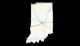
travels east–west across the state passing through Indianapolis. Interstate 70 crosses into Indiana near Terre Haute and crosses into Ohio
in Richmond
. It covers 156.60 miles in Indiana. It parallels U.S. Route 40, the old National Road
.
soon after crossing into Indiana. US 40 runs concurrent with I-70 briefly before breaking off and travelling north of I-70. The interstate then crosses through Terre Haute. I-70 intersects with US 41 and US 150 in Terre Haute. Just outside the city, I-70 passes near Terre Haute International Airport
. I-70 continues to the northeast towards Indianapolis
.
Interstate 70 passes near the Indianapolis International Airport
before intersecting with I-465. The interstate crosses the White River
before passing south of downtown Indianapolis
. The section of I-70 along the east side of downtown Indianapolis overlaps Interstate 65
. The junctions are often referred to as the "North Split" and the "South Split," forming the eastern leg of a section of freeways and surface streets locally known as the "Inner Loop" (as opposed to the "Outer Loop" of the I-465
beltway). The north split is also called the "Spaghetti Bowl
" due to the visual complexity of the overlapping freeways, ghost ramps
and overpasses that were originally intended as a connection to a never-built portion of Interstate 69
. East of the downtown area, I-70 intersects with the I-465 loop and traverses east towards Ohio. I-70 reaches a maximum width of five lanes in the Indianapolis area.
A portion of I-70 east of Indianapolis is known as the "Anton Tony Hulman Jr. Memorial Way." Tony Hulman
is most known for rescuing the Indianapolis Motor Speedway
in 1945 and making the Indianapolis 500
popular. I-70 does not intersect any significant cities until it reaches Richmond
. It does pass within proximity of Greenfield
and New Castle
. On the northwest side of Richmond, US 35 joins I-70 until it crosses into Ohio
. It also intersects with US 27 providing access to Richmond south of the interstate. On the east side of Richmond, US 40 intersects with I-70 immediately to the west of the Ohio border.
}
|Eastbound exit and westbound entrance
|-
|81.69
|83A
|Ohio Street
|Westbound exit and eastbound entrance
|-
|81.78
|83A
|New York Street, Michigan Street
|Westbound exit and eastbound entrance
|-
|82.20
|83B
| – Chicago
|East end of I-65 overlap
|-
|84.33
|85
|Rural Street south, Keystone Avenue north
|Signed as exits 85A (south) and 85B (north)
|-
|86.20
|87
|Emerson Avenue
|
|-
|88.47
|89
|Shadeland Avenue
|
|-
|89.04
|90
|
|Signed as exit 89 eastbound
|-
|90.38
|91
|Post Road
|
|-
|rowspan=2|Hancock
|
|95.61
|96
|Mount Comfort
Road
|
|-
|Greenfield
|103.31
|104
|
|
|-
|rowspan=3|Henry
|
|114.93
|115
|
|
|-
|
|122.68
|123
|
|
|-
|
|130.62
|131
|Wilbur Wright Road
|
|-
|rowspan=7|Wayne
|
|136.92
|137
|
|
|-
|
|144.88
|145
|Centerville
Road
|
|-
|rowspan=3|Richmond
|148.64
|149A
|Williamsburg Pike
|
|-
|148.74
|149B
|
|West end of US 35 overlap
|-
|150.67
|151
|
|
|-
|
|152.24
|153
|
|
|-
|Richmond
|155.56
|156
| – Lewisburg
|Signed as exits 156A (west) and 156B (east)
|}
U.S. state
A U.S. state is any one of the 50 federated states of the United States of America that share sovereignty with the federal government. Because of this shared sovereignty, an American is a citizen both of the federal entity and of his or her state of domicile. Four states use the official title of...
of Indiana
Indiana
Indiana is a US state, admitted to the United States as the 19th on December 11, 1816. It is located in the Midwestern United States and Great Lakes Region. With 6,483,802 residents, the state is ranked 15th in population and 16th in population density. Indiana is ranked 38th in land area and is...
, Interstate 70
Interstate 70
Interstate 70 is an Interstate Highway in the United States that runs from Interstate 15 near Cove Fort, Utah, to a Park and Ride near Baltimore, Maryland. It was the first Interstate Highway project in the United States. I-70 approximately traces the path of U.S. Route 40 east of the Rocky...
travels east–west across the state passing through Indianapolis. Interstate 70 crosses into Indiana near Terre Haute and crosses into Ohio
Ohio
Ohio is a Midwestern state in the United States. The 34th largest state by area in the U.S.,it is the 7th‑most populous with over 11.5 million residents, containing several major American cities and seven metropolitan areas with populations of 500,000 or more.The state's capital is Columbus...
in Richmond
Richmond, Indiana
Richmond is a city largely within Wayne Township, Wayne County, in east central Indiana, United States, which borders Ohio. The city also includes the Richmond Municipal Airport, which is in Boston Township and separated from the rest of the city...
. It covers 156.60 miles in Indiana. It parallels U.S. Route 40, the old National Road
National Road
The National Road or Cumberland Road was the first major improved highway in the United States to be built by the federal government. Construction began heading west in 1811 at Cumberland, Maryland, on the Potomac River. It crossed the Allegheny Mountains and southwestern Pennsylvania, reaching...
.
Route description
The Indiana portion of Interstate 70 begins on the Illinois border west of Indianapolis, near Terre Haute. Heading east, I-70 crosses the Wabash RiverWabash River
The Wabash River is a river in the Midwestern United States that flows southwest from northwest Ohio near Fort Recovery across northern Indiana to southern Illinois, where it forms the Illinois-Indiana border before draining into the Ohio River, of which it is the largest northern tributary...
soon after crossing into Indiana. US 40 runs concurrent with I-70 briefly before breaking off and travelling north of I-70. The interstate then crosses through Terre Haute. I-70 intersects with US 41 and US 150 in Terre Haute. Just outside the city, I-70 passes near Terre Haute International Airport
Terre Haute International Airport
Terre Haute International Airport is a public airport located east of the central business district of Terre Haute, a city in Vigo County, Indiana, United States. It is included in the FAA's National Plan of Integrated Airport Systems for 2011–2015, which categorized it as a general aviation...
. I-70 continues to the northeast towards Indianapolis
Indianapolis
Indianapolis is the capital of the U.S. state of Indiana, and the county seat of Marion County, Indiana. As of the 2010 United States Census, the city's population is 839,489. It is by far Indiana's largest city and, as of the 2010 U.S...
.
Interstate 70 passes near the Indianapolis International Airport
Indianapolis International Airport
Indianapolis International Airport is a public airport located seven miles southwest of the central business district of Indianapolis, a city in Marion County, Indiana, United States. It is owned and operated by the Indianapolis Airport Authority...
before intersecting with I-465. The interstate crosses the White River
White River (Indiana)
The White River is a two-forked river that flows through central and southern Indiana and is the main tributary to the Wabash River. Via the west fork, considered to be the main stem of the river by the U.S. Board on Geographic Names, the White River is long.-West Fork:The West Fork, long, is...
before passing south of downtown Indianapolis
Downtown Indianapolis
The term Downtown Indianapolis refers to the central business district of Indianapolis, Indiana, USA. The boundaries of downtown Indianapolis have varied over time as the city has grown. The city's original platted area, the Mile Square, is sometimes used to denote the downtown area...
. The section of I-70 along the east side of downtown Indianapolis overlaps Interstate 65
Interstate 65 in Indiana
In the U.S. state of Indiana, Interstate 65 traverses the state from south to north. The Indiana portion begins near Louisville, Kentucky and travels north, passing through Columbus, Indianapolis, Lafayette. Interstate 65 terminates near Gary on the Indiana Toll Road. Interstate 65 covers 261.27...
. The junctions are often referred to as the "North Split" and the "South Split," forming the eastern leg of a section of freeways and surface streets locally known as the "Inner Loop" (as opposed to the "Outer Loop" of the I-465
Interstate 465
Interstate 465 , also known as the USS Indianapolis Memorial Highway, is the beltway circling Indianapolis, Indiana, United States. It is roughly rectangular in shape and has a perimeter of approximately 53 miles . It lies almost completely within the boundaries of Marion County, except for two...
beltway). The north split is also called the "Spaghetti Bowl
Spaghetti Bowl
Spaghetti Bowl is a term used to describe a network of highway interconnects that looks like spaghetti in a bowl when viewed from overhead, also known as a Spaghetti Junction. The name is frequently only used by locals...
" due to the visual complexity of the overlapping freeways, ghost ramps
Unused highway
An unused highway is a highway or highway ramp that was partially or fully constructed, but was unused or later closed. An unused ramp can be referred to as a stub ramp, stub street, stub-out, or simply stub.-Examples:...
and overpasses that were originally intended as a connection to a never-built portion of Interstate 69
Interstate 69
Interstate 69 is an Interstate Highway in the United States. It exists in two parts: a completed highway from Indianapolis, Indiana, northeast to the Canadian border in Port Huron, Michigan, and a mostly proposed extension southwest to the Mexican border in Texas...
. East of the downtown area, I-70 intersects with the I-465 loop and traverses east towards Ohio. I-70 reaches a maximum width of five lanes in the Indianapolis area.
A portion of I-70 east of Indianapolis is known as the "Anton Tony Hulman Jr. Memorial Way." Tony Hulman
Tony Hulman
Anton "Tony" Hulman, Jr. was a businessman from Terre Haute, Indiana who rescued the Indianapolis Motor Speedway in 1945 and made the Indianapolis 500 popular....
is most known for rescuing the Indianapolis Motor Speedway
Indianapolis Motor Speedway
The Indianapolis Motor Speedway, located in Speedway, Indiana in the United States, is the home of the Indianapolis 500-Mile Race and the Brickyard 400....
in 1945 and making the Indianapolis 500
Indianapolis 500
The Indianapolis 500-Mile Race, also known as the Indianapolis 500, the 500 Miles at Indianapolis, the Indy 500 or The 500, is an American automobile race, held annually, typically on the last weekend in May at the Indianapolis Motor Speedway in Speedway, Indiana...
popular. I-70 does not intersect any significant cities until it reaches Richmond
Richmond, Indiana
Richmond is a city largely within Wayne Township, Wayne County, in east central Indiana, United States, which borders Ohio. The city also includes the Richmond Municipal Airport, which is in Boston Township and separated from the rest of the city...
. It does pass within proximity of Greenfield
Greenfield, Indiana
-Demographics:As of the census of 2000, there were 14,600 people, 5,917 households, and 4,017 families residing in the city. The population density was 1,818.0 people per square mile . There were 6,449 housing units at an average density of 803.0 per square mile...
and New Castle
New Castle, Indiana
As of the census of 2000, there were 17,780 people, 7,462 households, and 4,805 families residing in the city. The population density was 2,987.5 people per square mile . There were 8,042 housing units at an average density of 1,351.3 per square mile...
. On the northwest side of Richmond, US 35 joins I-70 until it crosses into Ohio
Ohio
Ohio is a Midwestern state in the United States. The 34th largest state by area in the U.S.,it is the 7th‑most populous with over 11.5 million residents, containing several major American cities and seven metropolitan areas with populations of 500,000 or more.The state's capital is Columbus...
. It also intersects with US 27 providing access to Richmond south of the interstate. On the east side of Richmond, US 40 intersects with I-70 immediately to the west of the Ohio border.
Exit list
| County | Location | Mile | # Exit number An exit number is a number assigned to a road junction, usually an exit from a freeway. It is usually marked on the same sign as the destinations of the exit, as well as a sign in the gore.... |
Destinations | Notes |
|---|---|---|---|---|---|
| Vigo Vigo County, Indiana Vigo County is a county located along the western border of the U.S. state of Indiana. Vigo County is included in the Terre Haute, Indiana, Metropolitan Statistical Area. The county seat is Terre Haute.... |
1.07 | 1 | East end of US 40 overlap; eastbound exit and westbound entrance | ||
| 3.40 | 3 | Darwin Road – West Terre Haute West Terre Haute, Indiana West Terre Haute is a town in Sugar Creek Township, Vigo County, Indiana, on the western side of the Wabash River near Terre Haute. The population was 2,236 at the 2010 census... |
|||
| Terre Haute Terre Haute, Indiana Terre Haute is a city and the county seat of Vigo County, Indiana, United States, near the state's western border with Illinois. As of the 2010 census, the city had a total population of 60,785 and its metropolitan area had a population of 170,943. The city is the county seat of Vigo County and... |
6.84 | 7 | |||
| 11.18 | 11 | Serves Terre Haute International Airport Terre Haute International Airport Terre Haute International Airport is a public airport located east of the central business district of Terre Haute, a city in Vigo County, Indiana, United States. It is included in the FAA's National Plan of Integrated Airport Systems for 2011–2015, which categorized it as a general aviation... |
|||
| Clay Clay County, Indiana Clay County is a county located in the U.S. state of Indiana. As of 2010, the population was 26,890. The county seat is Brazil. Clay County is included in the Terre Haute, Indiana, Metropolitan Statistical Area.- History :Clay County was formed in 1825... |
22.57 | 23 | |||
| Putnam Putnam County, Indiana As of the census of 2000, there were 36,019 people, 12,374 households, and 9,119 families residing in the county. The population density was 75 people per square mile . There were 13,505 housing units at an average density of 28 per square mile... |
37.09 | 37 | |||
| Cloverdale Cloverdale, Indiana Cloverdale is a town in Cloverdale and Warren townships, Putnam County, Indiana, United States. The population was 2,172 at the 2010 census.-Geography:Cloverdale is located at .... |
41.11 | 41 | |||
| Morgan Morgan County, Indiana Morgan County is a county located in the U.S. state of Indiana. As of 2010, the population was 68,894. The county seat is Martinsville. Morgan is one of seven counties contiguous to Marion County, and is located between Indianapolis, in Marion County, and Bloomington, located in Monroe County... |
50.65 | 51 | County Road 1100 West | ||
| Hendricks Hendricks County, Indiana - Towns :*Amo*Avon*Brownsburg*Clayton*Coatesville*Danville*Lizton*North Salem*Pittsboro*Plainfield*Stilesville-Townships:*Brown*Center*Clay*Eel River*Franklin*Guilford*Liberty*Lincoln*Marion*Middle*Union*Washington-Further reading:... |
59.21 | 59 | |||
| Plainfield Plainfield, Indiana As of the census of 2000, there were 18,396 people, 7,051 households, and 4,914 families residing in the town. The population density was 1,023.1 people per square mile . There were 7,449 housing units at an average density of 414.3 per square mile... |
66.22 | 66 | |||
| 68.32 | 68 | Ameriplex Parkway, Ronald Reagan Parkway – Indianapolis International Airport Indianapolis International Airport Indianapolis International Airport is a public airport located seven miles southwest of the central business district of Indianapolis, a city in Marion County, Indiana, United States. It is owned and operated by the Indianapolis Airport Authority... access road |
Signed as exits 68A (south) and 68B (north) eastbound | ||
| Marion Marion County, Indiana Marion County is a county located in the U.S. state of Indiana. Census 2010 recorded a population of 903,393, making it the largest county in the state and 55th most populated county in the country, greater than the population of six states. The county seat is Indianapolis, the state capital and... |
Indianapolis Indianapolis, Indiana Indianapolis is the capital of the U.S. state of Indiana, and the county seat of Marion County, Indiana. As of the 2010 United States Census, the city's population is 839,489. It is by far Indiana's largest city and, as of the 2010 U.S... |
72.75 | 69- 73 |
Signed as exits 69 (east/south) and 73 (west/north) eastbound and exits 73A (east/south) and 73B (west/north) westbound | |
| 74.53 | 75 | Sam Jones Expressway to Raymond Street | |||
| 76.38 | 77 | Holt Road | |||
| 78.42 | 78 | Harding Street | |||
| 79.47 | 79A | West Street | |||
| 80.01 | 79B | Illinois Street, McCarty Street | |||
| 80.72 | 80 | – Louisville Louisville, Kentucky Louisville is the largest city in the U.S. state of Kentucky, and the county seat of Jefferson County. Since 2003, the city's borders have been coterminous with those of the county because of a city-county merger. The city's population at the 2010 census was 741,096... |
West end of I-65 overlap | ||
| 80.77 | 110A | East Street | Westbound exit only | ||
| 81.01 | 83A | Fletcher Avenue | Westbound exit and eastbound entrance | ||
| 81.51 | 111 |
|Eastbound exit and westbound entrance
|-
|81.69
|83A
|Ohio Street
|Westbound exit and eastbound entrance
|-
|81.78
|83A
|New York Street, Michigan Street
|Westbound exit and eastbound entrance
|-
|82.20
|83B
| – Chicago
|East end of I-65 overlap
|-
|84.33
|85
|Rural Street south, Keystone Avenue north
|Signed as exits 85A (south) and 85B (north)
|-
|86.20
|87
|Emerson Avenue
|
|-
|88.47
|89
|Shadeland Avenue
|
|-
|89.04
|90
|
|Signed as exit 89 eastbound
|-
|90.38
|91
|Post Road
|
|-
|rowspan=2|Hancock
Hancock County, Indiana
Hancock County is a county located in the U.S. state of Indiana. As of 2010, the population was 70,002. The county seat is Greenfield.-Geography:...
|
|95.61
|96
|Mount Comfort
Mount Comfort, Indiana
Mount Comfort is an unincorporated town in Buck Creek Township, Hancock County, Indiana....
Road
|
|-
|Greenfield
Greenfield, Indiana
-Demographics:As of the census of 2000, there were 14,600 people, 5,917 households, and 4,017 families residing in the city. The population density was 1,818.0 people per square mile . There were 6,449 housing units at an average density of 803.0 per square mile...
|103.31
|104
|
|
|-
|rowspan=3|Henry
Henry County, Indiana
As of the census of 2000, there were 48,508 people, 19,486 households, and 13,971 families residing in the county. The population density was 124 people per square mile . There were 20,592 housing units at an average density of 52 per square mile...
|
|114.93
|115
|
|
|-
|
|122.68
|123
|
|
|-
|
|130.62
|131
|Wilbur Wright Road
|
|-
|rowspan=7|Wayne
Wayne County, Indiana
Wayne County is a county located in the U.S. state of Indiana. As of the 2010 census, the population was 68,917. The county seat is Richmond.-History:...
|
|136.92
|137
|
|
|-
|
|144.88
|145
|Centerville
Centerville, Indiana
Centerville is a town in Center Township, Wayne County, Indiana, United States. The population was 2,552 at the 2010 census.-Geography:Centerville is located at , at an altitude of 1,014 feet . U.S...
Road
|
|-
|rowspan=3|Richmond
Richmond, Indiana
Richmond is a city largely within Wayne Township, Wayne County, in east central Indiana, United States, which borders Ohio. The city also includes the Richmond Municipal Airport, which is in Boston Township and separated from the rest of the city...
|148.64
|149A
|Williamsburg Pike
|
|-
|148.74
|149B
|
|West end of US 35 overlap
|-
|150.67
|151
|
|
|-
|
|152.24
|153
|
|
|-
|Richmond
Richmond, Indiana
Richmond is a city largely within Wayne Township, Wayne County, in east central Indiana, United States, which borders Ohio. The city also includes the Richmond Municipal Airport, which is in Boston Township and separated from the rest of the city...
|155.56
|156
| – Lewisburg
Lewisburg, Ohio
Lewisburg is a village in Preble County, Ohio, United States, founded in 1818. The current village incorporates two prior villages, the original Lewisburg and Euphemia, which merged in 1916. The population was 1,798 at the 2000 census. It is part of the Dayton Metropolitan Statistical...
|Signed as exits 156A (west) and 156B (east)
|}
Popular culture
- The sign to I-70 in Indianapolis is shown at the beginning of the intro for One Day at a TimeOne Day at a TimeOne Day at a Time is an American situation comedy on the CBS network that aired from December 16, 1975 until May 28, 1984. It portrays Ann Romano, a divorced mother, played by Bonnie Franklin, her two teenage daughters Julie and Barbara Cooper and Schneider, their building superintendent .The show...
.