

U.S. Route 24 in Indiana
Encyclopedia
U.S. Route 24 In Indiana
, US 24 runs east from the Illinois
state line to Huntington
. At Huntington, US 24 turns northeast and runs to Fort Wayne
; it then overlaps Interstate 69
(I-69) and Interstate 469
(I-469) to bypass the city before entering Ohio
at the state line east of Fort Wayne. The segment of US 24 between Logansport
and Toledo, Ohio
is part of the Hoosier Heartland Industrial Corridor project of the Intermodal Surface Transportation Efficiency Act
.
, passing through an intersection
with State Road 71
(SR 71). In Kentland US 24 and US 52 have an intersection with U.S. Route 41
(US 41) where US 52 turns south. US 24 heads east from Kentland towards Remington
, passing through a concurrency
with State Road 55
. Then in Remington US 24 starts a concurrency with U.S. Route 231. US 24 and US 231 heads east towards Wolcott
, passing through an interchange
with Interstate 65
(I-65). In Wolcott US 231 heads south and US 24 heads east towards Reynolds
. In Reynolds US 24 has an intersection with State Road 43
(SR 43) and starts a concurrency with U.S. Route 421
(US 421). US 24 and US 421 heads east towards Monticello
. In Monticello US 421 head south with State Road 39
(SR 39), US 24 now has a concurrency with SR 39. US 24 and SR 39 heads east from Monticello, east of Monticello SR 39 heads north. US 24 heads east towards Logansport, passing through Idaville
, Burnettsville
, and Lake Cicott
.
(SR 25) and an intersection with State Road 29
(SR 29). East of Logansport US 35 heads southeast towards Kokomo
. US 24 heads east towards Peru
passing through an interchange with U.S. Route 31 (US 31). on the north side of Peru US 24 has an intersection with State Road 19
(SR 19). From Peru US 24 heads east towards Wabash
passing through an intersection with State Road 115
9SR 115). In Wabash US 24 has intersections with State Road 15
(SR 15) and State Road 13
(SR 13). US 24 then heads towards Huntington passing through an intersection with State Road 524
(SR 524) and a short concurrency with State Road 105
(SR 105). On the west side of Huntington US 24 begains a concurrency with State Road 9
(SR 9). US 24 and SR 9 pass through an intersection with U.S. Route 224
(US 224)/State Road 5
(SR 5). North of Huntington SR 9 heads north and US 24 heads northeast towards Fort Wayne. On the way to Fort Wayne US 24 passes through an intersection with State Road 114
(SR 114). Then on the west side of Fort Wayne US 24 has an interchange with Interstate 69
(I-69).
(I-469). US 24 is concurrenct with I-469 until the east side of New Haven
, passing through interchanges with State Road 1
(SR 1), U.S. Route 27
(US 27), U.S. Route 33
(US 33), and U.S. Route 30
(US 30)/State Road 930
(SR 930). US 24 exits I-469 and heads northeast toward Ohio, on a two-lane rural highway. Then at State Road 101
(SR 101), US 24 turns south concurrenct with SR 101. Then after a short concurrency with SR 101 heads northeast towards Ohio on a new four-lane rural dived highway, US 24 then enters Ohio.
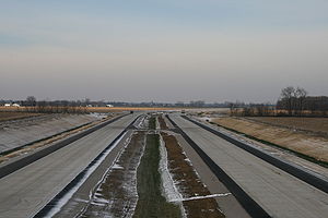
where US 24 comprises most of a High Priority Corridor and has been recently upgraded from a two-lane highway to a four-lane at-grade expressway
from Logansport
to Fort Wayne
. Further upgrades are planned for this corridor: US 24 from Fort Wayne to Toledo, Ohio
and State Road 25
(SR 25) from Logansport, Indiana
to Lafayette, Indiana
will be upgraded to similar standards. The grass roots effort to improve the section from New Haven, Indiana
(Fort Wayne) to Toledo started from a meeting organized by Indiana State Representative Mitch Harper
in 1989 at Woodburn, Indiana
. It was at this meeting that the project name 'Fort to Port' was born. There are no plans to upgrade the entire corridor to Interstate standards at this time, but maps from the 2005 Final Environmental Impact Statement (EIS) show that Indiana will build its portion as a freeway with no at-grade intersections. The most complex and expensive portion of the Indiana segment is reconstructing the interchange with Interstate 469
east of Fort Wayne. The existing parclo interchange
will be reconfigured with flyover ramps to allow high-speed movement of traffic through the interchange.
In November 2007, Indiana announced they would change their segment as an expressway with at-grade intersections at Bruick Road, Webster Road, and SR 101, instead of a freeway section with interchanges and overpasses. The only overpasses would be two narrow (12' wide) overpasses for non-motorized traffic (Amish
buggies) to cross US 24. Also, the interchange of I-469 and US 24 would remain as-is with traffic signals at the US 24 ramp terminals. The cost savings without interchanges would be approximately $75–$80 million. Right of way would be purchased for future interchanges. This change has been unpopular due to safety concerns with the heavy truck traffic on the corridor. INDOT claims that the current traffic on US 24 does not justify interchanges, even though the 2005 Final EIS states that it does.
 Responding to widespread public outcry over the scaled-back design, Governor Mitch Daniels
announced on December 12, 2007, that US 24 would have been built as a freeway initially from Bruick Road to the Ohio state line, with interchanges at SR 101 and Webster Road. The entire 13.5 miles (21.7 km) segment is slated for completion in 2012. The intersection with Bruick Road was to have initially been an at-grade crossing, but INDOT announced in August 2009 that a grade-separated interchange will be built here as well. As a result, Indiana's portion of US 24 will be built as an Interstate-quality freeway, except for the at-grade interchange with I-469. INDOT plans to eventually upgrade the I-469/US 24 interchange by adding flyover ramps to allow high-speed movements between the two highways, as was originally intended in the Fort-to-Port Final Environmental Impact Statement published in 2005. Depending on funding, this work may begin in 2013.
Upon completion, ownership of the existing US 24 will be transferred to Allen County
, and become a frontage road
east of Bruick Road, providing access to the B.F. Goodrich
tire plant and adjacent homes and farmland. Indiana is financing construction through the Major Moves
program, and will be reimbursed when federal highway funds become available. Sections of the two-lane road that have been bypassed by the freeway are now locally signed as "Old US 24."
Governor Daniels and INDOT held the groundbreaking ceremony for the Indiana section on April 30, 2008. By December 2008, crews had completed construction on 2 miles (3.2 km) of the freeway from the Ohio state line to just east of the SR 101 interchange. On October 29, 2009, Governor Daniels and Ohio Governor Ted Strickland
held a ribbon-cutting ceremony at the Indiana/Ohio state line opening the new US 24 highway from SR 101 near Woodburn, Indiana
to Ohio State Route 424
near Defiance, Ohio
.
Indiana
Indiana is a US state, admitted to the United States as the 19th on December 11, 1816. It is located in the Midwestern United States and Great Lakes Region. With 6,483,802 residents, the state is ranked 15th in population and 16th in population density. Indiana is ranked 38th in land area and is...
, US 24 runs east from the Illinois
Illinois
Illinois is the fifth-most populous state of the United States of America, and is often noted for being a microcosm of the entire country. With Chicago in the northeast, small industrial cities and great agricultural productivity in central and northern Illinois, and natural resources like coal,...
state line to Huntington
Huntington, Indiana
Huntington, known as the "Lime City", is a small city in and the county seat of Huntington County, Indiana, United States. It is in Huntington Township and Union Township...
. At Huntington, US 24 turns northeast and runs to Fort Wayne
Fort Wayne, Indiana
Fort Wayne is a city in the US state of Indiana and the county seat of Allen County. The population was 253,691 at the 2010 Census making it the 74th largest city in the United States and the second largest in Indiana...
; it then overlaps Interstate 69
Interstate 69 in Indiana
Interstate 69 presently exists in two discontinuous segments in Indiana. The original highway, completed in November 1971, runs northeast from the state capital of Indianapolis, to the city of Fort Wayne, and then proceeds north to the state of Michigan...
(I-69) and Interstate 469
Interstate 469
Interstate 469 is an Interstate Highway in the northeastern portion of the mid-western U.S. state of Indiana. It is an auxiliary route of parent Interstate 69 that also carries portions of US 24, US 30 and US 33 around the urban parts of Fort Wayne, Indiana...
(I-469) to bypass the city before entering Ohio
Ohio
Ohio is a Midwestern state in the United States. The 34th largest state by area in the U.S.,it is the 7th‑most populous with over 11.5 million residents, containing several major American cities and seven metropolitan areas with populations of 500,000 or more.The state's capital is Columbus...
at the state line east of Fort Wayne. The segment of US 24 between Logansport
Logansport, Indiana
Logansport is a city in and the county seat of Cass County, Indiana, United States. The population was 18,396 at the 2010 census. Logansport is located in northern Indiana, at the junction of the Wabash and Eel rivers, northeast of Lafayette.-History:...
and Toledo, Ohio
Toledo, Ohio
Toledo is the fourth most populous city in the U.S. state of Ohio and is the county seat of Lucas County. Toledo is in northwest Ohio, on the western end of Lake Erie, and borders the State of Michigan...
is part of the Hoosier Heartland Industrial Corridor project of the Intermodal Surface Transportation Efficiency Act
Intermodal Surface Transportation Efficiency Act
The Intermodal Surface Transportation Efficiency Act of 1991 is a United States federal law that posed a major change to transportation planning and policy, as the first U.S. federal legislation on the subject in the post-Interstate Highway System era...
.
Illinois to Logansport
This western section of US 24 is mostly, rural two-lane. US 24 enters Indiana from Illinois concurrenct with U.S. Route 52 (US 52). US 24 and US 52 heads east towards KentlandKentland, Indiana
Kentland is a town in Jefferson Township, Newton County, Indiana, United States. The population was 1,748 at the 2010 census. The town was founded in 1860 as "Kent", though this name was soon lengthened to Kentland. The name honors Alexander Kent, who acquired the then marshy plat and prepared it...
, passing through an intersection
Intersection (road)
An intersection is a road junction where two or more roads either meet or cross at grade . An intersection may be 3-way - a T junction or fork, 4-way - a crossroads, or 5-way or more...
with State Road 71
Indiana State Road 71
State Road 71 in west-central Indiana consists of two discontinuous north–south segments of two-lane rural roadway near the Illinois border.-Southern section:...
(SR 71). In Kentland US 24 and US 52 have an intersection with U.S. Route 41
U.S. Route 41 in Indiana
In the U.S. state of Indiana, U.S. Route 41 is a north–south highway that is parallel to the Illinois state line. It enters the state south of Evansville. North of Evansville, it becomes a 4-Lane divided highway passing around Vincennes and traveling North to Terre Haute. In Terre Haute, it...
(US 41) where US 52 turns south. US 24 heads east from Kentland towards Remington
Remington, Indiana
Remington is a town in Carpenter Township, Jasper County, Indiana, United States. The population was 1,185 at the 2010 census.-History:Remington was first laid out in 1860 by Jesse H. Fordice. It was originally called Carpenter Station, after Carpenter's Creek where a railroad station had been...
, passing through a concurrency
Concurrency (road)
A concurrency, overlap, or coincidence in a road network is an instance of one physical road bearing two or more different highway, motorway, or other route numbers...
with State Road 55
Indiana State Road 55
State Road 55 is a north–south road in Northern and Central Indiana. State Road 55 runs from the Crawfordsville area in the south to Gary in the north, a distance of approximately .-Route description:...
. Then in Remington US 24 starts a concurrency with U.S. Route 231. US 24 and US 231 heads east towards Wolcott
Wolcott, Indiana
Wolcott is a town in Princeton Township, White County, Indiana, United States. The population was 1,001 at the 2010 census.-Geography:Wolcott is located at ....
, passing through an interchange
Interchange (road)
In the field of road transport, an interchange is a road junction that typically uses grade separation, and one or more ramps, to permit traffic on at least one highway to pass through the junction without directly crossing any other traffic stream. It differs from a standard intersection, at which...
with Interstate 65
Interstate 65 in Indiana
In the U.S. state of Indiana, Interstate 65 traverses the state from south to north. The Indiana portion begins near Louisville, Kentucky and travels north, passing through Columbus, Indianapolis, Lafayette. Interstate 65 terminates near Gary on the Indiana Toll Road. Interstate 65 covers 261.27...
(I-65). In Wolcott US 231 heads south and US 24 heads east towards Reynolds
Reynolds, Indiana
Reynolds is a town in Honey Creek Township, White County, Indiana, United States. The population was 533 at the 2010 census.-Geography:Reynolds is located at ....
. In Reynolds US 24 has an intersection with State Road 43
Indiana State Road 43
-Southern section:This winding, two-lane section of State Road 43 connects Indiana State Road 46 in Owen County near McCormick's Creek State Park with Indiana State Road 54 in eastern Greene County. It covers a distance of .-Northern section:...
(SR 43) and starts a concurrency with U.S. Route 421
U.S. Route 421 in Indiana
U.S. Route 421 enters Indiana from Kentucky, proceeding northwest to Indianapolis, joining Interstate 465, then continuing northwest to Michigan City....
(US 421). US 24 and US 421 heads east towards Monticello
Monticello, Indiana
Monticello is a city in White County, Indiana, United States. The population was 5,378 at the 2010 census. The city is the county seat of White County....
. In Monticello US 421 head south with State Road 39
Indiana State Road 39
State Road 39 in the U.S. State of Indiana is the name of two distinct north–south highways in the state of Indiana.-Southern section:Located in south-central Indiana, the shorter southern section of State Road 39 begins at State Road 56 west of Scottsburg. It runs north and passes through...
(SR 39), US 24 now has a concurrency with SR 39. US 24 and SR 39 heads east from Monticello, east of Monticello SR 39 heads north. US 24 heads east towards Logansport, passing through Idaville
Idaville, Indiana
Idaville is an unincorporated town in Lincoln Township, White County, Indiana. It had a population of 461 at the 2010 census....
, Burnettsville
Burnettsville, Indiana
Burnettsville is a town in Jackson Township, White County, Indiana, United States. The population was 346 at the 2010 census.-Geography:Burnettsville is located at ....
, and Lake Cicott
Lake Cicott, Indiana
Lake Cicott is an unincorporated town in Jefferson Township, Cass County, Indiana.-Geography:The town of Lake Cicott is located at at the eastern end of Lake Cicott....
.
Logansport to Fort Wayne
This section is a four-lane rural divied highway. US 24 and U.S. Route 35 (US 35) have a concurrency around Logansport and have an interchange with State Road 25Indiana State Road 25
State Road 25 is a highway in the U. S. state of Indiana. Although it is designated a north–south road, in practice it travels generally northeast from its southern terminus at State Road 32 to its northern terminus at State Road 15 in Warsaw.- Waynetown to Lafayette :SR 25 heads north...
(SR 25) and an intersection with State Road 29
Indiana State Road 29
-Route description:The southern terminus of State Road 29 is at U.S. Route 421 and State Road 28 just south of the small town of Boyleston. Going north, it passes through Michigantown in Clinton County, then along the eastern border of Carroll County where it passes through Burlington. Its...
(SR 29). East of Logansport US 35 heads southeast towards Kokomo
Kokomo, Indiana
Kokomo is a city in and the county seat of Howard County, Indiana, United States, Indiana's 13th largest city. It is the principal city of the Kokomo, Indiana Metropolitan Statistical Area, which includes all of Howard and Tipton counties....
. US 24 heads east towards Peru
Peru, Indiana
-Demographics:As of the census of 2000, there were 12,994 people, 5,410 households, and 3,397 families residing in the city. The population density was 2,815.5 people per square mile . There were 5,943 housing units at an average density of 1,287.7 per square mile...
passing through an interchange with U.S. Route 31 (US 31). on the north side of Peru US 24 has an intersection with State Road 19
Indiana State Road 19
State Road 19 in the U.S. state of Indiana begins at State Road 32 in Noblesville in the south, and runs north to the Michigan state line just north of Elkhart, a distance of...
(SR 19). From Peru US 24 heads east towards Wabash
Wabash, Indiana
Wabash is a city in Noble Township, Wabash County, Indiana, United States. The population was 10,666 at the 2010 census. The city is the county seat of Wabash County....
passing through an intersection with State Road 115
Indiana State Road 115
State Road 115 in the U.S. state of Indiana is a short route in Wabash County just west of the town of Wabash.-Route description:The southern terminus of State Road 115 is at U.S. Route 24; it runs straight north to its northern terminus where it intersects with its parent route, State Road 15...
9SR 115). In Wabash US 24 has intersections with State Road 15
Indiana State Road 15
State Road 15 is a north–south road in northeastern Indiana. Its southern terminus is at State Road 22 in Jonesboro. Its northern terminus is the Michigan state line north of Bristol. It is a surface highway that is mostly rural...
(SR 15) and State Road 13
Indiana State Road 13
State Road 13 in the U.S. State of Indiana is a north–south highway in north-central and central Indiana that connects the area east of Indianapolis with the northern part of the state. Its northern terminus is at the Michigan state line, although starting at the interchange with the Indiana...
(SR 13). US 24 then heads towards Huntington passing through an intersection with State Road 524
Indiana State Road 524
State Road 524 in the U.S. state of Indiana is a spur of U.S. Route 24 which goes east to Lagro and then south toward the Salamonie River State Forest.- Route description :...
(SR 524) and a short concurrency with State Road 105
Indiana State Road 105
State Road 105 is a north–south road in Northern Indiana in Huntington and Whitley counties.-Route description:State Road 105 begins at State Road 9 east of La Fontaine and runs north, crossing State Road 124 west of Mount Etna. It then passes through Lost Bridge State Recreation Area and...
(SR 105). On the west side of Huntington US 24 begains a concurrency with State Road 9
Indiana State Road 9
State Road 9 in the U.S. State of Indiana is a long north–south state highway in the eastern portion of Indiana. Its southern terminus is near Columbus at State Road 46, and the northern terminus is at the Michigan/Indiana border between Howe, Indiana, and Sturgis, Michigan, where it...
(SR 9). US 24 and SR 9 pass through an intersection with U.S. Route 224
U.S. Route 224 in Indiana
U.S. Route 224 is a part of the United States Numbered Highway that runs from Huntington, Indiana to New Castle, Pennsylvania. In Indiana, it is a rural, two-lane route that travels in the northern part of the state. The western terminus is at U.S. Route 24, State Road 5, and State Road 9...
(US 224)/State Road 5
Indiana State Road 5
State Road 5 is a north–south road that runs through northeast Indiana. Its southern terminus is at SR 22 in Upland, and the northern terminus is at SR 120 just north of Shipshewana. The largest city along its path is Huntington...
(SR 5). North of Huntington SR 9 heads north and US 24 heads northeast towards Fort Wayne. On the way to Fort Wayne US 24 passes through an intersection with State Road 114
Indiana State Road 114
State Road 114 in the U.S. State of Indiana consists of three discontinuous east–west routes, between the Illinois border and U.S. Route 421, State Road 17 and State Road 25, and State Road 14 and U.S. Route 24.- Western section :...
(SR 114). Then on the west side of Fort Wayne US 24 has an interchange with Interstate 69
Interstate 69 in Indiana
Interstate 69 presently exists in two discontinuous segments in Indiana. The original highway, completed in November 1971, runs northeast from the state capital of Indianapolis, to the city of Fort Wayne, and then proceeds north to the state of Michigan...
(I-69).
Fort Wayne to Ohio
This section of US 24 has some interstate sections, rural two-lane highway, and rural four-lane divied highways. US 24 enters I-69 heading south at exit 102. US 24 then leaves I-69 and US 24 heads east on Interstate 469Interstate 469
Interstate 469 is an Interstate Highway in the northeastern portion of the mid-western U.S. state of Indiana. It is an auxiliary route of parent Interstate 69 that also carries portions of US 24, US 30 and US 33 around the urban parts of Fort Wayne, Indiana...
(I-469). US 24 is concurrenct with I-469 until the east side of New Haven
New Haven, Indiana
-Demographics:As of the census of 2000, there were 12,406 people, 4,900 households, and 3,415 families residing in the city. The population density was 1,522.0 people per square mile . There were 5,141 housing units at an average density of 630.7 per square mile...
, passing through interchanges with State Road 1
Indiana State Road 1
State Road 1 is a north–south state highway in the eastern portion of the U.S. state of Indiana. Its southern terminus is at U.S. Highway 50 in east-central Dearborn County, just east of Lawrenceburg. Its northern terminus is at U.S...
(SR 1), U.S. Route 27
U.S. Route 27 in Indiana
U.S. Route 27 enters Indiana in southeastern part of the state south of the village of Liberty. At Liberty, US 27 turns north, paralleling the Ohio state line. It intersects Interstate 70/U.S. Route 40 at Richmond and continues north to Decatur...
(US 27), U.S. Route 33
U.S. Route 33 in Indiana
U.S. Route 33 is a mainly two-lane U.S. Highway running through northeast Indiana. The highway travels from southeast to northwest.-Route description:...
(US 33), and U.S. Route 30
U.S. Route 30 in Indiana
In the state of Indiana, U.S. Route 30 is an east–west four-lane divided highway across northern Indiana. It runs from the Illinois state line at Dyer to east of Fort Wayne at the Ohio state line. This is a distance of 151.8 miles ....
(US 30)/State Road 930
Indiana State Road 930
State Road 930 is a 900-series state highway entirely within greater Fort Wayne, Indiana.-Route description:SR 930 western terminus is at an interchange with Interstate 69, U.S. Route 30 , and U.S. Route 33 . SR 930 heads southeast on Goshen Ave. from the interchange to West Coliseum Blvd...
(SR 930). US 24 exits I-469 and heads northeast toward Ohio, on a two-lane rural highway. Then at State Road 101
Indiana State Road 101
State Road 101 in the U.S. state of Indiana is a north–south state highway in the eastern portion of Indiana that exists in four sections with a combined length of .-First section:...
(SR 101), US 24 turns south concurrenct with SR 101. Then after a short concurrency with SR 101 heads northeast towards Ohio on a new four-lane rural dived highway, US 24 then enters Ohio.
Logansport to Fort Wayne
In Logansport US 24 went through Logansport. The frist route of US 24 was two-lane undived rural highway north of the new four-lane highway from Logansport to Peru and south of the four-lane highway from Peru to Huntington. From Huntington to Fort Wayne the four-lane highway was built over the two-lane highway.Fort Wayne to New Haven
Before US 24 was rerouted onto I-69 and I-469, US 24 went through Fort Wayne. US 24 went through downtown on one-way streets. Then east of Fort Wayne US 24 has an interchange with US 30 and then a concurrency with US 30, now known as SR 930. Then US 24 headed downtown New Haven, with US 30 bypassing downtown New Haven. Then US 24 headed north out of downtown New Haven and then turned east.Future
Major upgrades have taken place throughout much of IndianaIndiana
Indiana is a US state, admitted to the United States as the 19th on December 11, 1816. It is located in the Midwestern United States and Great Lakes Region. With 6,483,802 residents, the state is ranked 15th in population and 16th in population density. Indiana is ranked 38th in land area and is...
where US 24 comprises most of a High Priority Corridor and has been recently upgraded from a two-lane highway to a four-lane at-grade expressway
Limited-access road
A limited-access road known by various terms worldwide, including limited-access highway, dual-carriageway and expressway, is a highway or arterial road for high-speed traffic which has many or most characteristics of a controlled-access highway , including limited or no access to adjacent...
from Logansport
Logansport, Indiana
Logansport is a city in and the county seat of Cass County, Indiana, United States. The population was 18,396 at the 2010 census. Logansport is located in northern Indiana, at the junction of the Wabash and Eel rivers, northeast of Lafayette.-History:...
to Fort Wayne
Fort Wayne, Indiana
Fort Wayne is a city in the US state of Indiana and the county seat of Allen County. The population was 253,691 at the 2010 Census making it the 74th largest city in the United States and the second largest in Indiana...
. Further upgrades are planned for this corridor: US 24 from Fort Wayne to Toledo, Ohio
Toledo, Ohio
Toledo is the fourth most populous city in the U.S. state of Ohio and is the county seat of Lucas County. Toledo is in northwest Ohio, on the western end of Lake Erie, and borders the State of Michigan...
and State Road 25
Indiana State Road 25
State Road 25 is a highway in the U. S. state of Indiana. Although it is designated a north–south road, in practice it travels generally northeast from its southern terminus at State Road 32 to its northern terminus at State Road 15 in Warsaw.- Waynetown to Lafayette :SR 25 heads north...
(SR 25) from Logansport, Indiana
Logansport, Indiana
Logansport is a city in and the county seat of Cass County, Indiana, United States. The population was 18,396 at the 2010 census. Logansport is located in northern Indiana, at the junction of the Wabash and Eel rivers, northeast of Lafayette.-History:...
to Lafayette, Indiana
Lafayette, Indiana
Lafayette is a city in and the county seat of Tippecanoe County, Indiana, United States, northwest of Indianapolis. As of the 2010 census, the city had a total population of 67,140. West Lafayette, on the other side of the Wabash River, is home to Purdue University, which has a large impact on...
will be upgraded to similar standards. The grass roots effort to improve the section from New Haven, Indiana
New Haven, Indiana
-Demographics:As of the census of 2000, there were 12,406 people, 4,900 households, and 3,415 families residing in the city. The population density was 1,522.0 people per square mile . There were 5,141 housing units at an average density of 630.7 per square mile...
(Fort Wayne) to Toledo started from a meeting organized by Indiana State Representative Mitch Harper
Mitch Harper
Mitchell V. "Mitch" Harper is an American politician from Fort Wayne, Indiana.He was elected as a Fort Wayne Common Council member from the 4th District on November 6, 2007. He was elected to a second term on November 8, 2011. He currently serves as President of the Common Council.Harper served as...
in 1989 at Woodburn, Indiana
Woodburn, Indiana
Woodburn is a city in Maumee Township, Allen County, Indiana, United States. The population was 1,520 at the 2010 census, making it the smallest incorporated city in the state.-Geography:Woodburn is located at ....
. It was at this meeting that the project name 'Fort to Port' was born. There are no plans to upgrade the entire corridor to Interstate standards at this time, but maps from the 2005 Final Environmental Impact Statement (EIS) show that Indiana will build its portion as a freeway with no at-grade intersections. The most complex and expensive portion of the Indiana segment is reconstructing the interchange with Interstate 469
Interstate 469
Interstate 469 is an Interstate Highway in the northeastern portion of the mid-western U.S. state of Indiana. It is an auxiliary route of parent Interstate 69 that also carries portions of US 24, US 30 and US 33 around the urban parts of Fort Wayne, Indiana...
east of Fort Wayne. The existing parclo interchange
Parclo interchange
A partial cloverleaf interchange or parclo is a modification of a cloverleaf interchange. The parclo interchange was developed by the Ontario Ministry of Transportation as a replacement for the cloverleaf on 400-Series Highways, removing the dangerous weaving patterns and allowing for more...
will be reconfigured with flyover ramps to allow high-speed movement of traffic through the interchange.
In November 2007, Indiana announced they would change their segment as an expressway with at-grade intersections at Bruick Road, Webster Road, and SR 101, instead of a freeway section with interchanges and overpasses. The only overpasses would be two narrow (12' wide) overpasses for non-motorized traffic (Amish
Amish
The Amish , sometimes referred to as Amish Mennonites, are a group of Christian church fellowships that form a subgroup of the Mennonite churches...
buggies) to cross US 24. Also, the interchange of I-469 and US 24 would remain as-is with traffic signals at the US 24 ramp terminals. The cost savings without interchanges would be approximately $75–$80 million. Right of way would be purchased for future interchanges. This change has been unpopular due to safety concerns with the heavy truck traffic on the corridor. INDOT claims that the current traffic on US 24 does not justify interchanges, even though the 2005 Final EIS states that it does.
Mitch Daniels
Mitchell Elias "Mitch" Daniels, Jr. is the 49th and current Governor of the U.S. state of Indiana. A Republican, he began his first four-year term as governor on January 10, 2005, and was elected to his second term by an 18-point margin on November 4, 2008. Previously, he was the Director of the...
announced on December 12, 2007, that US 24 would have been built as a freeway initially from Bruick Road to the Ohio state line, with interchanges at SR 101 and Webster Road. The entire 13.5 miles (21.7 km) segment is slated for completion in 2012. The intersection with Bruick Road was to have initially been an at-grade crossing, but INDOT announced in August 2009 that a grade-separated interchange will be built here as well. As a result, Indiana's portion of US 24 will be built as an Interstate-quality freeway, except for the at-grade interchange with I-469. INDOT plans to eventually upgrade the I-469/US 24 interchange by adding flyover ramps to allow high-speed movements between the two highways, as was originally intended in the Fort-to-Port Final Environmental Impact Statement published in 2005. Depending on funding, this work may begin in 2013.
Upon completion, ownership of the existing US 24 will be transferred to Allen County
Allen County, Indiana
As of the census of 2000, there were 331,849 people, 128,745 households, and 86,259 families residing in the county. The population density was 505 people per square mile . There were 138,905 housing units at an average density of 211 per square mile...
, and become a frontage road
Frontage road
A frontage road is a non-limited access road running parallel to a higher-speed road, usually a freeway, and feeding it at appropriate points of access...
east of Bruick Road, providing access to the B.F. Goodrich
BFGoodrich
BFGoodrich is an American brand of tires. Separated from the Goodrich company and now owned by Michelin.Some Michelin competition tyres are now branded BFGoodrich to increase brand awareness....
tire plant and adjacent homes and farmland. Indiana is financing construction through the Major Moves
Major Moves
Major Moves is a studio album by American country music artist Hank Williams, Jr. It was released by Warner Bros. Records in May 1984. "Attitude Adjustment," "All My Rowdy Friends Are Coming Over Tonight" and the title track were released as singles...
program, and will be reimbursed when federal highway funds become available. Sections of the two-lane road that have been bypassed by the freeway are now locally signed as "Old US 24."
Governor Daniels and INDOT held the groundbreaking ceremony for the Indiana section on April 30, 2008. By December 2008, crews had completed construction on 2 miles (3.2 km) of the freeway from the Ohio state line to just east of the SR 101 interchange. On October 29, 2009, Governor Daniels and Ohio Governor Ted Strickland
Ted Strickland
Theodore "Ted" Strickland was the 68th Governor of Ohio, serving from 2007 to 2011. A member of the Democratic Party, he previously served in the United States House of Representatives, representing ....
held a ribbon-cutting ceremony at the Indiana/Ohio state line opening the new US 24 highway from SR 101 near Woodburn, Indiana
Woodburn, Indiana
Woodburn is a city in Maumee Township, Allen County, Indiana, United States. The population was 1,520 at the 2010 census, making it the smallest incorporated city in the state.-Geography:Woodburn is located at ....
to Ohio State Route 424
Ohio State Route 424
State Route 424 is an east–west state highway in the northwestern portion of the U.S. state of Ohio. Its western terminus is at the Defiance County/Henry County line, and its eastern terminus is at U.S. Route 24 near Napoleon....
near Defiance, Ohio
Defiance, Ohio
As of the census of 2000, there were 16,465 people, 6,572 households, and 4,422 families residing in the city. The population density was 1,562.4 people per square mile . There were 7,061 housing units at an average density of 670.0 per square mile...
.