
Indiana State Road 18
Encyclopedia
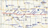
State Road 18 in the U.S. State
of Indiana
is an east–west route in North Central Indiana running from the Illinois
border in Benton County
almost to the Ohio
border, terminating at U.S. Route 27
(US 27)/State Road 67
(SR 67) in Jay County
. State Route 18 is mainly a 2 lane road with exception of 4 lane divided highway from Marion to Interstate 69
(I-69). Marion is the only considerably large city that Route 18 passes through. State Route 18 runs just south of the lakes region, with Lake Shafer, Lake Freeman, Mississinewa Reservoir, and Salamonie Reservoir not too far to the north. Along State Route 18, you will see small farming towns and lots of flat ground.
with State Road 71
. SR 18 heads east having an intersection with U.S. Route 41
. Then SR 18 heads east towards Fowler
, when in Fowler SR 18 begins a concurrency
with U.S. Route 52 and Satte Road 55
. All three route head southeast, until SR 18 turns due east. SR 18 heads east towards Brookston
, passing through an intersection with U.S. Route 231 and an interchange
with Interstate 65
(I-65). In Brookston SR 18 has a concurrency with State Road 43
. From Brookston SR 18 heads east towards Pittsburg
, just west of Pittsburg SR 18, begins a concurrency with U.S. Route 421
, and State Road 39
. All three route heads southeast towards Delphi
, west of downtown Delphi State Road 25
joins the concurrency. Then all four routes turn northeast towards downtown Delphi. When in downtown Delphi SR 25 leaves the concurrency on a northeast route as US 421/SR 18/SR 39 turn southeast. South of Delphi SR 18 leaves the concurrency with US 421 and SR 39. SR 18 heads due east towards Flora
where SR 18 has an intersection with State Road 75
. SR 18 heads east towards Galveston
passing through a concurrency with State Road 29
. In Galveston SR 18 has an intersection with U.S. Route 35. Then just east of Galveston SR 18 has an intersection with U.S. Route 31.
From US 31, SR 18 heads east towards Converse
passing through a concurrency with State Road 19
. SR 18 then heads through Converse, after Converse SR 18 has a concurrency with State Road 13
. SR 18 turns southeast towards Marion
passing through Sweetser
. In Marion eastbound SR 18 is on a Fourth Street and westbound SR 18 is on Third Street and Second Street. East of Marion the one-way streets become a four-lane highway. SR 18 heads east towards Montpelier
passing through an interchange with I-69 and passing through an intersection with State Road 5
and State Road 3
. East of Montpelier SR 18 passes through an intersection with State Road 1
. Then SR 18 heads east towards its eastern terminus near Bryant
at an intersection with US 27 and SR 67, from this intersection SR 67 heads east towards Ohio
.
U.S. state
A U.S. state is any one of the 50 federated states of the United States of America that share sovereignty with the federal government. Because of this shared sovereignty, an American is a citizen both of the federal entity and of his or her state of domicile. Four states use the official title of...
of Indiana
Indiana
Indiana is a US state, admitted to the United States as the 19th on December 11, 1816. It is located in the Midwestern United States and Great Lakes Region. With 6,483,802 residents, the state is ranked 15th in population and 16th in population density. Indiana is ranked 38th in land area and is...
is an east–west route in North Central Indiana running from the Illinois
Illinois
Illinois is the fifth-most populous state of the United States of America, and is often noted for being a microcosm of the entire country. With Chicago in the northeast, small industrial cities and great agricultural productivity in central and northern Illinois, and natural resources like coal,...
border in Benton County
Benton County, Indiana
Benton County is located along in the northwest part of the U.S. state of Indiana, along the border with Illinois. As of 2010, the county's population was 8,854. It contains six incorporated towns as well as several small unincorporated settlements; it is also divided into 11 townships which...
almost to the Ohio
Ohio
Ohio is a Midwestern state in the United States. The 34th largest state by area in the U.S.,it is the 7th‑most populous with over 11.5 million residents, containing several major American cities and seven metropolitan areas with populations of 500,000 or more.The state's capital is Columbus...
border, terminating at U.S. Route 27
U.S. Route 27 in Indiana
U.S. Route 27 enters Indiana in southeastern part of the state south of the village of Liberty. At Liberty, US 27 turns north, paralleling the Ohio state line. It intersects Interstate 70/U.S. Route 40 at Richmond and continues north to Decatur...
(US 27)/State Road 67
Indiana State Road 67
State Road 67 in the U.S. State of Indiana cuts a diagonal route from southwest to northeast across the state from the north side of Vincennes to Indianapolis to the Ohio state line, where it becomes State Route 29 east of Bryant.-Route description:...
(SR 67) in Jay County
Jay County, Indiana
As of the census of 2000, there were 21,806 people, 8,405 households, and 6,017 families residing in the county. The population density was 57 people per square mile . There were 9,074 housing units at an average density of 24 per square mile...
. State Route 18 is mainly a 2 lane road with exception of 4 lane divided highway from Marion to Interstate 69
Interstate 69 in Indiana
Interstate 69 presently exists in two discontinuous segments in Indiana. The original highway, completed in November 1971, runs northeast from the state capital of Indianapolis, to the city of Fort Wayne, and then proceeds north to the state of Michigan...
(I-69). Marion is the only considerably large city that Route 18 passes through. State Route 18 runs just south of the lakes region, with Lake Shafer, Lake Freeman, Mississinewa Reservoir, and Salamonie Reservoir not too far to the north. Along State Route 18, you will see small farming towns and lots of flat ground.
Route description
SR 18 heads east from the western terminus at the Illinois State line. Then SR 18 has an intersectionIntersection (road)
An intersection is a road junction where two or more roads either meet or cross at grade . An intersection may be 3-way - a T junction or fork, 4-way - a crossroads, or 5-way or more...
with State Road 71
Indiana State Road 71
State Road 71 in west-central Indiana consists of two discontinuous north–south segments of two-lane rural roadway near the Illinois border.-Southern section:...
. SR 18 heads east having an intersection with U.S. Route 41
U.S. Route 41 in Indiana
In the U.S. state of Indiana, U.S. Route 41 is a north–south highway that is parallel to the Illinois state line. It enters the state south of Evansville. North of Evansville, it becomes a 4-Lane divided highway passing around Vincennes and traveling North to Terre Haute. In Terre Haute, it...
. Then SR 18 heads east towards Fowler
Fowler, Indiana
-External links:*...
, when in Fowler SR 18 begins a concurrency
Concurrency (road)
A concurrency, overlap, or coincidence in a road network is an instance of one physical road bearing two or more different highway, motorway, or other route numbers...
with U.S. Route 52 and Satte Road 55
Indiana State Road 55
State Road 55 is a north–south road in Northern and Central Indiana. State Road 55 runs from the Crawfordsville area in the south to Gary in the north, a distance of approximately .-Route description:...
. All three route head southeast, until SR 18 turns due east. SR 18 heads east towards Brookston
Brookston, Indiana
Brookston is a town in Prairie Township, White County, Indiana, United States. The population was 1,554 as of the 2010 census.-Geography:Brookston is located at ....
, passing through an intersection with U.S. Route 231 and an interchange
Interchange (road)
In the field of road transport, an interchange is a road junction that typically uses grade separation, and one or more ramps, to permit traffic on at least one highway to pass through the junction without directly crossing any other traffic stream. It differs from a standard intersection, at which...
with Interstate 65
Interstate 65 in Indiana
In the U.S. state of Indiana, Interstate 65 traverses the state from south to north. The Indiana portion begins near Louisville, Kentucky and travels north, passing through Columbus, Indianapolis, Lafayette. Interstate 65 terminates near Gary on the Indiana Toll Road. Interstate 65 covers 261.27...
(I-65). In Brookston SR 18 has a concurrency with State Road 43
Indiana State Road 43
-Southern section:This winding, two-lane section of State Road 43 connects Indiana State Road 46 in Owen County near McCormick's Creek State Park with Indiana State Road 54 in eastern Greene County. It covers a distance of .-Northern section:...
. From Brookston SR 18 heads east towards Pittsburg
Pittsburg, Indiana
Pittsburg is an unincorporated town in Tippecanoe Township, Carroll County, Indiana. It is part of the Lafayette, Indiana Metropolitan Statistical Area.-Geography:...
, just west of Pittsburg SR 18, begins a concurrency with U.S. Route 421
U.S. Route 421 in Indiana
U.S. Route 421 enters Indiana from Kentucky, proceeding northwest to Indianapolis, joining Interstate 465, then continuing northwest to Michigan City....
, and State Road 39
Indiana State Road 39
State Road 39 in the U.S. State of Indiana is the name of two distinct north–south highways in the state of Indiana.-Southern section:Located in south-central Indiana, the shorter southern section of State Road 39 begins at State Road 56 west of Scottsburg. It runs north and passes through...
. All three route heads southeast towards Delphi
Delphi, Indiana
Delphi is a city in and the county seat of Carroll County, Indiana, United States. Located twenty minutes northeast of Lafayette, it is part of the Lafayette, Indiana Metropolitan Statistical Area...
, west of downtown Delphi State Road 25
Indiana State Road 25
State Road 25 is a highway in the U. S. state of Indiana. Although it is designated a north–south road, in practice it travels generally northeast from its southern terminus at State Road 32 to its northern terminus at State Road 15 in Warsaw.- Waynetown to Lafayette :SR 25 heads north...
joins the concurrency. Then all four routes turn northeast towards downtown Delphi. When in downtown Delphi SR 25 leaves the concurrency on a northeast route as US 421/SR 18/SR 39 turn southeast. South of Delphi SR 18 leaves the concurrency with US 421 and SR 39. SR 18 heads due east towards Flora
Flora, Indiana
Flora is a town in Monroe Township, Carroll County, Indiana, United States. The population was 2,036 at the 2010 census. It is part of the Lafayette, Indiana Metropolitan Statistical Area.-Geography:Flora is located at ....
where SR 18 has an intersection with State Road 75
Indiana State Road 75
State Road 75, the highest two-digit route in the U.S. state of Indiana consists of two discontinuous north–south segments.-Southern section:...
. SR 18 heads east towards Galveston
Galveston, Indiana
Galveston is a town in Jackson Township, Cass County, Indiana, USA. The population was 1,460 at the 2006 census.-Geography:Galveston is located at .According to the United States Census Bureau, the town has a total area of , all of it land....
passing through a concurrency with State Road 29
Indiana State Road 29
-Route description:The southern terminus of State Road 29 is at U.S. Route 421 and State Road 28 just south of the small town of Boyleston. Going north, it passes through Michigantown in Clinton County, then along the eastern border of Carroll County where it passes through Burlington. Its...
. In Galveston SR 18 has an intersection with U.S. Route 35. Then just east of Galveston SR 18 has an intersection with U.S. Route 31.
From US 31, SR 18 heads east towards Converse
Converse, Indiana
Converse is a town in Richland Township, Grant County and Jackson Township, Miami County, Indiana, United States. The population was 1,148 at the 2010 census.-Geography:Converse is located at ....
passing through a concurrency with State Road 19
Indiana State Road 19
State Road 19 in the U.S. state of Indiana begins at State Road 32 in Noblesville in the south, and runs north to the Michigan state line just north of Elkhart, a distance of...
. SR 18 then heads through Converse, after Converse SR 18 has a concurrency with State Road 13
Indiana State Road 13
State Road 13 in the U.S. State of Indiana is a north–south highway in north-central and central Indiana that connects the area east of Indianapolis with the northern part of the state. Its northern terminus is at the Michigan state line, although starting at the interchange with the Indiana...
. SR 18 turns southeast towards Marion
Marion, Indiana
Marion is a city in Grant County, Indiana, United States. The population was 29,948 as of the 2010 census. The city is the county seat of Grant County...
passing through Sweetser
Sweetser, Indiana
Sweetser is a town in Franklin, Pleasant and Richland townships, Grant County, Indiana, United States. The population was 906 at the 2000 census.-Geography:...
. In Marion eastbound SR 18 is on a Fourth Street and westbound SR 18 is on Third Street and Second Street. East of Marion the one-way streets become a four-lane highway. SR 18 heads east towards Montpelier
Montpelier, Indiana
Montpelier is an American city in Blackford County, Indiana. This small rural community, the county’s first to be platted, was established by settlers from Vermont, and is named after Vermont’s capital city – Montpelier....
passing through an interchange with I-69 and passing through an intersection with State Road 5
Indiana State Road 5
State Road 5 is a north–south road that runs through northeast Indiana. Its southern terminus is at SR 22 in Upland, and the northern terminus is at SR 120 just north of Shipshewana. The largest city along its path is Huntington...
and State Road 3
Indiana State Road 3
State Road 3 in the U.S. State of Indiana is a discontinuous state road running through east central Indiana from near the Michigan state line to near the Ohio River...
. East of Montpelier SR 18 passes through an intersection with State Road 1
Indiana State Road 1
State Road 1 is a north–south state highway in the eastern portion of the U.S. state of Indiana. Its southern terminus is at U.S. Highway 50 in east-central Dearborn County, just east of Lawrenceburg. Its northern terminus is at U.S...
. Then SR 18 heads east towards its eastern terminus near Bryant
Bryant, Indiana
Bryant is a town in Bearcreek Township, Jay County, Indiana, United States. The population was 252 at the 2010 census.-Geography:Bryant is located at .According to the United States Census Bureau, the town has a total area of , all of it land....
at an intersection with US 27 and SR 67, from this intersection SR 67 heads east towards Ohio
Ohio
Ohio is a Midwestern state in the United States. The 34th largest state by area in the U.S.,it is the 7th‑most populous with over 11.5 million residents, containing several major American cities and seven metropolitan areas with populations of 500,000 or more.The state's capital is Columbus...
.