
Hurricane Mitch
Encyclopedia
Hurricane Mitch was the most powerful hurricane
and the most destructive of the 1998 Atlantic hurricane season
, with maximum sustained winds of 180 mph (285 km/h). The storm was the thirteenth tropical storm, ninth hurricane, and third major hurricane of the season
. Along with Hurricane Georges
, Mitch was the most notable hurricane in the season. At the time, Hurricane Mitch was the strongest Atlantic hurricane observed in the month of October, though it has since been surpassed by Hurricane Wilma
of the 2005 season
. The hurricane matched the fourth most intense Atlantic hurricane on record (it has since dropped to seventh).
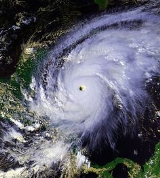
Mitch formed in the western Caribbean Sea
on October 22, and after drifting through extremely favorable conditions, it rapidly strengthened to peak at Category 5 status, the highest possible rating on the Saffir-Simpson Hurricane Scale
. After drifting southwestward and weakening, the hurricane hit Honduras
as a minimal hurricane. It drifted through Central America
, reformed in the Bay of Campeche
, and ultimately struck Florida
as a strong tropical storm.
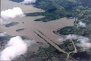
Due to its slow motion from October 29 to November 3, Hurricane Mitch dropped historic amounts of rainfall in Honduras
, Guatemala
, and Nicaragua
, with unofficial reports of up to 75 in (1900 mm). Deaths due to catastrophic flooding made it the second deadliest Atlantic hurricane in history; nearly 11,000 people were killed with over 11,000 left missing by the end of 1998. Additionally, roughly 2.7 million were left homeless as a result of the hurricane. The flooding caused extreme damage, estimated at over $6 billion (1998 USD
, $ USD).
that moved off the coast of Africa on October 10. It moved westward across the shear
-ridden Atlantic Ocean
, and remained disorganized until entering the Caribbean Sea
on October 18. Upon entering the western Caribbean Sea, convection
steadily increased, and on October 22, the wave organized into Tropical Depression Thirteen while 415 mi (670 km) south of Kingston, Jamaica
. Under weak steering currents, it drifted westward and intensified into a tropical storm on October 23 while 260 mi (420 km) east-southeast of San Andrés Island
.
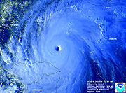
Initially, intensification was limited due to an upper-level low causing vertical wind shear
over Tropical Storm Mitch. As the storm executed a small loop to the north, the shear weakened, allowing the system to strengthen. Mitch attained hurricane status on October 24 while 295 mi (475 km) south of Jamaica, and with warm water temperatures and well-defined outflow, the hurricane rapidly strengthened. During a 48-hour period from October 23 to October 25, the central pressure dropped 52 mbar
, and on October 26, Mitch reached peak intensity with 180 mph (290 km/h) winds and a pressure of 905 mbar, one of the lowest pressures ever recorded in an Atlantic hurricane.
 The hurricane moved westward, resulting in land interaction with Honduras
. This weakened Mitch slightly, and after passing over the Swan Islands
on October 27, the hurricane steadily weakened. The hurricane drifted southward along the Honduran coastline, and made landfall 80 mi (130 km) east of La Ceiba
in Honduras
on October 29 as a Category 1 hurricane on the Saffir-Simpson hurricane scale
with 80 mph (130 km/h) winds. It continued to weaken over land, drifting westward through Central America
, and its low-level circulation dissipated on November 1 near the Guatemala
-Mexico
border.
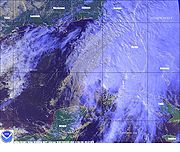
The remnant area of low pressure drifted northward into the Bay of Campeche
, and reorganized on November 3 into a tropical storm while 150 mi (240 km) southwest of Mérida, Yucatán
. Mitch moved to the northeast, making landfall on the Yucatán Peninsula
near Campeche
on November 4. It weakened to a tropical depression over land, but restrengthened to a tropical storm over the southeastern Gulf of Mexico
. As Mitch accelerated to the northeast in association with a cold front, it gradually intensified, and made landfall near Naples, Florida
on November 5 as a tropical storm with 65 mph (100 km/h) winds. Mitch became extratropical later that day, but it continued to persist for several days before losing its identity north of Great Britain
on November 9.
evacuated some of the 45,000 citizens on the Bay Islands
and prepared all air and naval resources. The government of Belize issued a red alert and asked for citizens on offshore islands to leave for the mainland. Because the hurricane threatened to strike near Belize City
as a Category 4 hurricane, much of the city was evacuated in fear of a repeat of Hurricane Hattie
37 years earlier. Guatemala issued a red alert as well, recommending boats to stay in port, telling people to prepare or seek shelter, and warning of potential overflown rivers. By the time Mitch made landfall, numerous people were evacuated along the western Caribbean coastline, including 100,000 in Honduras, 10,000 in Guatemala, and 20,000 in the Mexican state of Quintana Roo
.
Hurricane Mitch was the deadliest Atlantic hurricane since the Great Hurricane of 1780
, displacing the Galveston Hurricane of 1900
as the second-deadliest on record. Nearly eleven thousand people were confirmed dead, and almost as many reported missing. Deaths were mostly from flood
ing and mudslides
in Central America, where the slow-moving hurricane and then tropical storm dropped nearly 3 feet (900 mm) of rain. The flooding and mudslides damaged or destroyed tens of thousands of homes, with total damage amounting to over $5 billion (1998 USD, $6 billion 2006 USD), most of which was in Honduras
and Nicaragua
. Prior to Mitch, the deadliest hurricane in Central America was Hurricane Fifi
in 1974, which killed an estimated 8,000–10,000.
 Prior to hitting Honduras
, Hurricane Mitch sent waves of up to 22 feet (6.7 m) in height to the coast. Upon making landfall, it diminished in intensity, but still caused a strong storm surge and waves of 12 feet (3.7 m) in height. While the storm was drifting over the country, it dropped extreme rainfall peaking at nearly 36 inches (91 cm) in Choluteca
, where over 18 inches (46 cm) of rain fell in one day. The rainfall in Choluteca was equivalent to the average rainfall total in 212 days. The Choluteca River
at this point flooded to six times its normal width. The widespread flooding was partially caused by Honduras' slash and burn agriculture, so the forests could not absorb any moisture. In addition, there were estimates of as high as 75 inches (190 cm) in mountainous regions. The rainfall collected in rivers, causing extensive river flooding across the country. The deepest average depth was 12.5 meters on the Ulúa River
near Chinda
, while the average widest length was 359 meters on the Río Lean near Arizona
. The rainfall also caused widespread mudslides across the mountainous country.
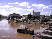
 Mitch caused such massive and widespread damage that Honduran President
Carlos Roberto Flores
claimed it destroyed fifty years of progress in the country. An estimated 70–80% of the transportation infrastructure of the entire country was wiped out, including nearly all bridges and secondary roads; the damage was so great that existing maps were rendered obsolete. About 25 small villages were reported to have been entirely destroyed by the landslides caused by the storm. Damages to the transportation and communication network totaled to $529 million (1998 USD, $718 million 2011 USD). Across the country, the storm destroyed 33,000 houses and damaged 50,000 others. In addition, it downed numerous trees, leaving mountainsides bare and more vulnerable to mudslides.
 Mitch's rainfall resulted in severe crop losses in the country, affecting more than 300 square miles (800 km2) or 29% of the country's arable land. The NCDC
estimated the flooding destroyed at least 70% of the country's crops. Food crops were severely impacted, including destruction of 58% of the corn output, 24% of sorghum, 14% of rice, and 6% of the bean crop. Several important export crops faced similar losses, including 85% of banana, 60% of sugar cane, 29% of melons, 28% of African palms, and 18% of coffee. Crop damage alone was estimated anywhere from $900 million (1998 USD, $1.22 billion 2011 USD) to $1.7 billion (1998 USD, $2.31 billion 2011 USD). Large amounts of animal losses occurred as well, including the death of 50,000 cattle and the loss of 60% of the poultry population. Shrimp production, which had become an important export, faced nearly complete destruction. Total animal losses amounted to $300 million (1998 USD, $407 million 2011 USD).
The extreme flooding and mudslides killed over 6,500, with several thousand missing. Many of the unidentified were buried in mass graves, resulting in great uncertainty over the final death toll. Over 20% of the country's population, possibly as many as 1.5 million people, were left homeless. The severe crop shortages left many villages on the brink of starvation, while lack of sanitation led to outbreaks of malaria
, dengue fever
, and cholera
.
On the offshore island of Guanaja
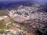
, the hurricane spent three days stalling near the island. Strong winds destroyed one third of the island's houses and left most citizens without power for months. The island's two fish packing plants were damaged while two main resorts were closed. Guanaja received little help from the national government, being a small (9 miles long, 14 km) island which has traditionally had an independent and self-reliant streak. Instead, international aid arrived from former Guanaja citizens, enough those citizens from the mainland came to the island to acquire supplies. In all, at least 7,000 were reported dead and damage was pegged at $3.8 billion in Honduras.
 Though Mitch never entered Nicaragua
, its large circulation caused extensive rainfall, with estimates of over 50 inches (127 cm). In some places, as much as 25 inches (64 cm) of rain fell on coastal areas. The flank of the Casita
Volcano failed and turned into a lahar
from excessive rain. The resulting mudslide
ultimately covered an area 10 miles (16 km) long and 5 miles (8 km) wide.
Two million people in Nicaragua were directly affected by the hurricane. Across the country, Mitch's heavy rains damaged 17,600 houses and destroyed 23,900, displacing 368,300 of the population. 340 schools and 90 health centers were severely damaged or destroyed. Sewage systems and the electricity subsector were severely damaged, and, combined with property, damage totaled to $300 million (1998 USD, $407 million 2011 USD).
 Transportation was greatly affected by the hurricane, as well. The rainfall left 70% of the roads unusable or destroyed and greatly damaged 92 bridges. Over 1,700 miles (2700 km) of highways or access roads needed replacement subsequent to the storm, especially in the northern part of the country and along portions of the Pan-American Highway
. Total transportation damage amounted to $300 million (1998 USD, $407 million 2011 USD). Agricultural losses were significant, including the deaths of 50,000 animals, mostly bovines. Crops and fisheries were affected greatly as well, and, combined with agricultural losses, damage totaled to $185 million (1998 USD, $251 million 2011 USD).
The situation was further compounded by a total of 75,000 live land mine
s—left over from the Contra insurgency of the 1980s—that were calculated to have been uprooted and relocated by the floodwaters.
In all, Hurricane Mitch caused at least 3,800 fatalities in Nicaragua, of which more than 2,000 were killed in the towns of El Provenir and Rolando Rodriguez from the landslide at the Casita volcano. The mudslide buried at least four villages completely in several feet of mud. Throughout the entire country, the hurricane left between 500,000 and 800,000 homeless. In all, damage in Nicaragua is estimated at around $1 billion (1998 USD, $1.36 billion 2011 USD).
sailing ship owned by Windjammer Barefoot Cruises
; all 31 of the crew perished. The story was recorded in the book The Ship and The Storm by Jim Carrier. The ship, which was sailing near the center of the hurricane, experienced over 50 foot (15 m) waves and over 100 mph (160 km/h) winds, causing the Fantome to sink off the coast of Honduras.
On the south coast of Cuba
, the hurricane caused waves of up to 13 feet (4 m) high and winds gusts peaking at 42 mph (67 km/h), causing numerous tourists and workers on the Isle of Youth and Cayo Largo del Sur
to leave for safer grounds.
In Jamaica
, where officials declared hurricane warnings 12 hours prior to its closest approach, Mitch caused moderate rainfall and gusty winds for days. Strong waves hit western Jamaica, with wave heights unofficially estimated at nearly 7 feet (2 m) in height. The rainfall in outer rainbands, at times severe, flooded many roads across the island and left them covered with debris. One house in Spanish Town
collapsed from the flooding, leaving four homeless. Many other homes and buildings were flooded, forcing many to evacuate. A river in northeastern Jamaica overflowed its banks, while heavy rainfall across the mountainous parts of the country caused numerous mudslides. In all, Mitch killed three people on Jamaica.
On the Cayman Islands
, the hurricane caused strong waves, gusty winds, and heavy rainfall at times. Damage was relatively minimal, amounting to blown out windows and beach erosion. Strong waves damaged or destroyed many docks on the south shore of the islands, and also sank one dive ship near Grand Cayman
. In addition, numerous incoming and outgoing flights were cancelled.
, especially in the Darién
and Chiriquí
provinces. The flooding washed away a few roads and bridges, and damaged numerous houses and schools, leaving thousands homeless. The hurricane left three casualties in Panama.
In Costa Rica
, Mitch dropped heavy rains, causing flash flooding and mudslides across the country, mostly in the northeastern part of the country. The storm impacted 2,135 homes to some degree, of which 242 were destroyed, leaving 4,000 homeless. Throughout the country, the rainfall and mudslides affected 126 bridges and 800 miles (1300 km) or roads, mostly on the Inter-American Highway
which was affected by Hurricane Cesar
, two years prior. Mitch affected 115 sq. miles (300 km2) of crop lands, causing damage to both export and domestic crops. In all, Hurricane Mitch caused $92 million in damage (1998 USD, $124.9 million 2011 USD) and seven deaths.
While drifting through El Salvador
, the hurricane dropped immense amounts of precipitation, resulting in flash flooding and mudslides through the country. Multiple rivers, including the Río Grande de San Miguel
and the Lempa River
overflowed, contributing to overall damage. The flooding damaged more than 10,000 houses, leaving around 84,000 homeless and forcing 500,000 to evacuate. Crop damage was severe, with serious flooding occurring on 386 sq. miles (1000 km2) of pasture or crop land. The flooding destroyed 37% of the bean production, 19% of the corn production, and 20% losses in sugar canes. There were heavy losses in livestock as well, including the deaths of 10,000 cattle. Total agricultural and livestock damaged amounted to $154 million (1998 USD, $209 million 2011 USD). In addition, the flooding destroyed two bridges and damaged 1,200 miles (2000 km) of unpaved roads. In all, Mitch caused nearly $400 million in damage (1998 USD, $543 million 2011 USD) and 240 deaths.
Similar to the rest of Central America, Mitch's heavy rains caused mudslides and severe flooding over Guatemala
. The flooding destroyed 6,000 houses and damaged 20,000 others, displacing over 730,000 and forcing over 100,000 to evacuate. In addition, the flooding destroyed 27 schools and damaged 286 others, 175 severely. Flooding caused major damage to crops, while landslides destroyed crop land across the country. The most severely affected crops for domestic consumption were tomatoes, bananas, corn, other vegetables, and beans, with damaged totaling to $48 million (1998 USD, $65 million 2011 USD). Export crops such as bananas or coffee were greatly damaged as well, with damage amounting to $325 million (1998 USD, $441 million 2011 USD). Damage to plantations and soil totaled to $121 million (1998 USD, $164 million 2011 USD). The flooding also caused severe damage to the transportation infrastructure, including the loss of 37 bridges. Across the country, flooding damaged or destroyed 840 miles (1350 km) of roads, of which nearly 400 miles (640 km) were sections of major highways. In all, Hurricane Mitch caused $748 million (1998 USD, $1.02 billion 2011 USD) and 268 deaths in Guatemala. In addition, Mitch caused 11 indirect deaths when a plane crashed during the storm.
In Belize
, the hurricane was less severe than initially predicted, though Mitch still caused heavy rainfall across the country. Numerous rivers exceeded their crests, though the rainfall was beneficial to trees in mountainous areas. The flooding caused extensive crop damage and destroyed many roads. Throughout the country, eleven people died because of the hurricane.
 In Mexico
, Mitch produced gusty winds and heavy rains on the Yucatán Peninsula
, with Cancún
on the Quintana Roo
coast being the worst hit. Nine people were killed from the flooding, though damage was relatively minimal. The maximum 24 hour rainfall total from Mitch was 13.4 inches (340.4 mm) in Campeche
, while the highest rainfall total was 16.85 inches (428 mm) in Ciudad del Carmen
.
before making landfall on the Florida
west coast. Key West International Airport
reported peak wind gusts of 55 mph (89 km/h) and sustained winds of 40 mph (64 km/h), the only report of tropical storm force in the state. Offshore, the Fowey Rocks Light
reported a wind gusts of 73 mph (117.5 km/h). In addition, Mitch caused moderate rainfall, peaking at 7 inches (18 cm) in Jupiter
, though some estimates indicate localized totals of up to 10 inches (25 cm). The storm spawned five tornadoes over the state, the strongest of which was an F2
.
In the Florida Keys, multiple buildings that had been damaged by Hurricane Georges
were leveled by Mitch. Tornadoes from the storm damaged or destroyed 645 houses across the state, in addition to injuring 65 people. Gusty winds left 100,000 without power during the storm's passage. In all, Mitch caused $40 million in damage (1998 USD, $54.3 million 2011 USD) in Florida and two deaths from drowning when two boats capsized.
Because of the hurricane's destruction in Central America
and elsewhere in North America, the World Meteorological Organization
retired the name Mitch in the spring of 1999; it will never again be used for an Atlantic hurricane. The name was replaced with Matthew
in the 2004 season
.
After the disaster caused by Hurricane Mitch, countries around the world donated significant aid, totaling $6.3 billion (1998 USD, $8.6 billion 2011 USD). Throughout Central America
, which was recovering from an economic crisis that occurred in 1996, many wished to continue the growth of the infrastructure and economy. In addition, after witnessing the vulnerability to hurricanes, the affected governments endeavored to prevent such a disaster from occurring again.
Hundreds of thousands of people lost their homes, but many took this as an opportunity to rebuild stronger houses. With a new, structurally improved foundation, homes were redesigned to be able to withstand another hurricane. However, lack of arable crop land took away the jobs from many, decreasing an already low income even lower.
Following the passage of Mitch, disease outbreaks occurred throughout Central America, including cholera
, leptospirosis
, and dengue fever
. Over 2,328 cases of cholera were reported, killing 34 people. Guatemala was most affected by the bacterium, where most of the deaths occurred from contaminated food. 450 cases of leptospirosis were reported in Nicaragua, killing seven people. There were over 1,357 cases of dengue reported, though no deaths were reported from the disease.
 While stalling over the western Caribbean Sea, Mitch's strong winds produced strong waves, damaging local coral reef
s. Later, the storm's immense rainfall led to runoff polluted with debris and fresh water. This resulted in diseases occurring within the coral. However, the hurricane's upwelling cooled the warm water temperatures, preventing significant bleaching and destruction of the coral reef.
Honduras, the country most affected by the hurricane, received significant aid for the millions impacted by the hurricane. Mexico quickly gave help, sending 700 tons of food, 11 tons of medicine, four rescue planes, rescue personnel, and trained search dogs. Cuba also volunteered, sending a contingent of physicians to the country. The U.S. administration offered at first troops stationed in Honduras, and then withdrew them a few days after the storm. They also at first offered only $2 million (1998 USD, $2.7 million 2011 USD) in aid, which came as a shock to residents, and president Carlos Roberto Flores alike. The U.S. later increased their offer to $70 million (1998 USD, $95 million 2011 USD). The Honduran government distributed food, water, and medical services to the hurricane victims, including the more than 4 million without water. President Flores turned the administration of the relief efforts to the church, both Protestant and Catholic. The relief effort was carried out with virtually no incidents; only one truck was discovered to be re-routed for personal use, and the person responsible for this was subsequently punished. In addition, the country initially experienced a sharp increase in the unemployment rate, largely due to the destruction of crop lands. However, rebuilding provided jobs in the following years. In Costa Rica
, reconstruction after the hurricane increased the number of jobs by 5.9%, lowering the unemployment rate slightly.
Tropical cyclone
A tropical cyclone is a storm system characterized by a large low-pressure center and numerous thunderstorms that produce strong winds and heavy rain. Tropical cyclones strengthen when water evaporated from the ocean is released as the saturated air rises, resulting in condensation of water vapor...
and the most destructive of the 1998 Atlantic hurricane season
1998 Atlantic hurricane season
The 1998 Atlantic hurricane season officially began on June 1, 1998, and lasted until November 30, 1998. These dates conventionally delimit the period of each year when most tropical cyclones form in the Atlantic basin; however, the season extended through December 1 as Hurricane Nicole remained...
, with maximum sustained winds of 180 mph (285 km/h). The storm was the thirteenth tropical storm, ninth hurricane, and third major hurricane of the season
Atlantic hurricane season
The Atlantic hurricane season is the period in a year when hurricanes usually form in the Atlantic Ocean. Tropical cyclones in the North Atlantic are called hurricanes, tropical storms, or tropical depressions. In addition, there have been several storms over the years that have not been fully...
. Along with Hurricane Georges
Hurricane Georges
Hurricane Georges was a very destructive, powerful and long-lived Cape Verde-type Category 4 hurricane. Georges was the seventh tropical storm, fourth hurricane, and second major hurricane of the 1998 Atlantic hurricane season...
, Mitch was the most notable hurricane in the season. At the time, Hurricane Mitch was the strongest Atlantic hurricane observed in the month of October, though it has since been surpassed by Hurricane Wilma
Hurricane Wilma
Hurricane Wilma was the most intense tropical cyclone ever recorded in the Atlantic basin. Wilma was the twenty-second storm , thirteenth hurricane, sixth major hurricane, and fourth Category 5 hurricane of the record-breaking 2005 season...
of the 2005 season
2005 Atlantic hurricane season
The 2005 Atlantic hurricane season was the most active Atlantic hurricane season in recorded history, repeatedly shattering numerous records. The impact of the season was widespread and ruinous with an estimated 3,913 deaths and record damage of about $159.2 billion...
. The hurricane matched the fourth most intense Atlantic hurricane on record (it has since dropped to seventh).
Mitch formed in the western Caribbean Sea
Caribbean Sea
The Caribbean Sea is a sea of the Atlantic Ocean located in the tropics of the Western hemisphere. It is bounded by Mexico and Central America to the west and southwest, to the north by the Greater Antilles, and to the east by the Lesser Antilles....
on October 22, and after drifting through extremely favorable conditions, it rapidly strengthened to peak at Category 5 status, the highest possible rating on the Saffir-Simpson Hurricane Scale
Saffir-Simpson Hurricane Scale
The Saffir–Simpson Hurricane Scale , or the Saffir–Simpson Hurricane Wind Scale , classifies hurricanes — Western Hemisphere tropical cyclones that exceed the intensities of tropical depressions and tropical storms — into five categories distinguished by the intensities of their sustained winds...
. After drifting southwestward and weakening, the hurricane hit Honduras
Honduras
Honduras is a republic in Central America. It was previously known as Spanish Honduras to differentiate it from British Honduras, which became the modern-day state of Belize...
as a minimal hurricane. It drifted through Central America
Central America
Central America is the central geographic region of the Americas. It is the southernmost, isthmian portion of the North American continent, which connects with South America on the southeast. When considered part of the unified continental model, it is considered a subcontinent...
, reformed in the Bay of Campeche
Bay of Campeche
The Bay of Campeche is the southern bight of the Gulf of Mexico. It is surrounded on three sides by the Mexican states of Campeche, Tabasco and Veracruz. It was named by Francisco Hernández de Córdoba and Antonio de Alaminos during their expedition in 1517...
, and ultimately struck Florida
Florida
Florida is a state in the southeastern United States, located on the nation's Atlantic and Gulf coasts. It is bordered to the west by the Gulf of Mexico, to the north by Alabama and Georgia and to the east by the Atlantic Ocean. With a population of 18,801,310 as measured by the 2010 census, it...
as a strong tropical storm.
Due to its slow motion from October 29 to November 3, Hurricane Mitch dropped historic amounts of rainfall in Honduras
Honduras
Honduras is a republic in Central America. It was previously known as Spanish Honduras to differentiate it from British Honduras, which became the modern-day state of Belize...
, Guatemala
Guatemala
Guatemala is a country in Central America bordered by Mexico to the north and west, the Pacific Ocean to the southwest, Belize to the northeast, the Caribbean to the east, and Honduras and El Salvador to the southeast...
, and Nicaragua
Nicaragua
Nicaragua is the largest country in the Central American American isthmus, bordered by Honduras to the north and Costa Rica to the south. The country is situated between 11 and 14 degrees north of the Equator in the Northern Hemisphere, which places it entirely within the tropics. The Pacific Ocean...
, with unofficial reports of up to 75 in (1900 mm). Deaths due to catastrophic flooding made it the second deadliest Atlantic hurricane in history; nearly 11,000 people were killed with over 11,000 left missing by the end of 1998. Additionally, roughly 2.7 million were left homeless as a result of the hurricane. The flooding caused extreme damage, estimated at over $6 billion (1998 USD
United States dollar
The United States dollar , also referred to as the American dollar, is the official currency of the United States of America. It is divided into 100 smaller units called cents or pennies....
, $ USD).
Meteorological history
The origin of Hurricane Mitch can be traced to a tropical waveTropical wave
Tropical waves, easterly waves, or tropical easterly waves, also known as African easterly waves in the Atlantic region, are a type of atmospheric trough, an elongated area of relatively low air pressure, oriented north to south, which move from east to west across the tropics causing areas of...
that moved off the coast of Africa on October 10. It moved westward across the shear
Wind shear
Wind shear, sometimes referred to as windshear or wind gradient, is a difference in wind speed and direction over a relatively short distance in the atmosphere...
-ridden Atlantic Ocean
Atlantic Ocean
The Atlantic Ocean is the second-largest of the world's oceanic divisions. With a total area of about , it covers approximately 20% of the Earth's surface and about 26% of its water surface area...
, and remained disorganized until entering the Caribbean Sea
Caribbean Sea
The Caribbean Sea is a sea of the Atlantic Ocean located in the tropics of the Western hemisphere. It is bounded by Mexico and Central America to the west and southwest, to the north by the Greater Antilles, and to the east by the Lesser Antilles....
on October 18. Upon entering the western Caribbean Sea, convection
Atmospheric convection
Atmospheric convection is the result of a parcel-environment instability, or temperature difference, layer in the atmosphere. Different lapse rates within dry and moist air lead to instability. Mixing of air during the day which expands the height of the planetary boundary layer leads to...
steadily increased, and on October 22, the wave organized into Tropical Depression Thirteen while 415 mi (670 km) south of Kingston, Jamaica
Kingston, Jamaica
Kingston is the capital and largest city of Jamaica, located on the southeastern coast of the island. It faces a natural harbour protected by the Palisadoes, a long sand spit which connects the town of Port Royal and the Norman Manley International Airport to the rest of the island...
. Under weak steering currents, it drifted westward and intensified into a tropical storm on October 23 while 260 mi (420 km) east-southeast of San Andrés Island
San Andrés (island)
San Andrés is a coral island among the Colombian islands in the Caribbean Sea; it is the largest island of the southern group of islands. Together with the nearby island of Providencia and some smaller islands of the southern group of the Colombian archipelago, San Andrés forms the department of...
.
Initially, intensification was limited due to an upper-level low causing vertical wind shear
Wind shear
Wind shear, sometimes referred to as windshear or wind gradient, is a difference in wind speed and direction over a relatively short distance in the atmosphere...
over Tropical Storm Mitch. As the storm executed a small loop to the north, the shear weakened, allowing the system to strengthen. Mitch attained hurricane status on October 24 while 295 mi (475 km) south of Jamaica, and with warm water temperatures and well-defined outflow, the hurricane rapidly strengthened. During a 48-hour period from October 23 to October 25, the central pressure dropped 52 mbar
Bar (unit)
The bar is a unit of pressure equal to 100 kilopascals, and roughly equal to the atmospheric pressure on Earth at sea level. Other units derived from the bar are the megabar , kilobar , decibar , centibar , and millibar...
, and on October 26, Mitch reached peak intensity with 180 mph (290 km/h) winds and a pressure of 905 mbar, one of the lowest pressures ever recorded in an Atlantic hurricane.
Honduras
Honduras is a republic in Central America. It was previously known as Spanish Honduras to differentiate it from British Honduras, which became the modern-day state of Belize...
. This weakened Mitch slightly, and after passing over the Swan Islands
Swan Islands, Honduras
The Swan Islands, or Islas Santanilla, are a chain of three islands located in the northwestern Caribbean Sea, approximately ninety miles off the coastline of Honduras, with a land area of .-Detailed location and features:...
on October 27, the hurricane steadily weakened. The hurricane drifted southward along the Honduran coastline, and made landfall 80 mi (130 km) east of La Ceiba
La Ceiba
La Ceiba is a port city on the northern coast of Honduras in Central America. It is located on the southern edge of the Caribbean, forming part of the south eastern boundary of the Gulf of Honduras...
in Honduras
Honduras
Honduras is a republic in Central America. It was previously known as Spanish Honduras to differentiate it from British Honduras, which became the modern-day state of Belize...
on October 29 as a Category 1 hurricane on the Saffir-Simpson hurricane scale
Saffir-Simpson Hurricane Scale
The Saffir–Simpson Hurricane Scale , or the Saffir–Simpson Hurricane Wind Scale , classifies hurricanes — Western Hemisphere tropical cyclones that exceed the intensities of tropical depressions and tropical storms — into five categories distinguished by the intensities of their sustained winds...
with 80 mph (130 km/h) winds. It continued to weaken over land, drifting westward through Central America
Central America
Central America is the central geographic region of the Americas. It is the southernmost, isthmian portion of the North American continent, which connects with South America on the southeast. When considered part of the unified continental model, it is considered a subcontinent...
, and its low-level circulation dissipated on November 1 near the Guatemala
Guatemala
Guatemala is a country in Central America bordered by Mexico to the north and west, the Pacific Ocean to the southwest, Belize to the northeast, the Caribbean to the east, and Honduras and El Salvador to the southeast...
-Mexico
Mexico
The United Mexican States , commonly known as Mexico , is a federal constitutional republic in North America. It is bordered on the north by the United States; on the south and west by the Pacific Ocean; on the southeast by Guatemala, Belize, and the Caribbean Sea; and on the east by the Gulf of...
border.
The remnant area of low pressure drifted northward into the Bay of Campeche
Bay of Campeche
The Bay of Campeche is the southern bight of the Gulf of Mexico. It is surrounded on three sides by the Mexican states of Campeche, Tabasco and Veracruz. It was named by Francisco Hernández de Córdoba and Antonio de Alaminos during their expedition in 1517...
, and reorganized on November 3 into a tropical storm while 150 mi (240 km) southwest of Mérida, Yucatán
Mérida, Yucatán
Mérida is the capital and largest city of the Mexican state of Yucatán and the Yucatán Peninsula. It is located in the northwest part of the state, about from the Gulf of Mexico coast...
. Mitch moved to the northeast, making landfall on the Yucatán Peninsula
Yucatán Peninsula
The Yucatán Peninsula, in southeastern Mexico, separates the Caribbean Sea from the Gulf of Mexico, with the northern coastline on the Yucatán Channel...
near Campeche
Campeche, Campeche
San Francisco de Campeche is the capital city of the Mexican state of Campeche, located at,...
on November 4. It weakened to a tropical depression over land, but restrengthened to a tropical storm over the southeastern Gulf of Mexico
Gulf of Mexico
The Gulf of Mexico is a partially landlocked ocean basin largely surrounded by the North American continent and the island of Cuba. It is bounded on the northeast, north and northwest by the Gulf Coast of the United States, on the southwest and south by Mexico, and on the southeast by Cuba. In...
. As Mitch accelerated to the northeast in association with a cold front, it gradually intensified, and made landfall near Naples, Florida
Naples, Florida
Naples is a city in Collier County, Florida, United States. As of July 1, 2007, the U.S. Census Bureau estimated the city's population at 21,653. Naples is a principal city of the Naples–Marco Island Metropolitan Statistical Area, which had an estimated total population of 315,839 on July 1, 2007...
on November 5 as a tropical storm with 65 mph (100 km/h) winds. Mitch became extratropical later that day, but it continued to persist for several days before losing its identity north of Great Britain
Great Britain
Great Britain or Britain is an island situated to the northwest of Continental Europe. It is the ninth largest island in the world, and the largest European island, as well as the largest of the British Isles...
on November 9.
Preparations
Due to the threat, the government of HondurasHonduras
Honduras is a republic in Central America. It was previously known as Spanish Honduras to differentiate it from British Honduras, which became the modern-day state of Belize...
evacuated some of the 45,000 citizens on the Bay Islands
Bay Islands (department)
Islas de la Bahía is one of the 18 departments into which the Central American nation of Honduras is divided. The departmental capital is Roatan, on the island of Roatán....
and prepared all air and naval resources. The government of Belize issued a red alert and asked for citizens on offshore islands to leave for the mainland. Because the hurricane threatened to strike near Belize City
Belize City
Belize City is the largest city in the Central American nation of Belize. Unofficial estimates place the population of Belize City at 70,000 or more. It is located at the mouth of the Belize River on the coast of the Caribbean. The city is the country's principal port and its financial and...
as a Category 4 hurricane, much of the city was evacuated in fear of a repeat of Hurricane Hattie
Hurricane Hattie
Hurricane Hattie was the deadliest tropical cyclone of the 1961 Atlantic hurricane season, as well as the strongest, reaching a peak intensity equivalent to Category 5 hurricane intensity...
37 years earlier. Guatemala issued a red alert as well, recommending boats to stay in port, telling people to prepare or seek shelter, and warning of potential overflown rivers. By the time Mitch made landfall, numerous people were evacuated along the western Caribbean coastline, including 100,000 in Honduras, 10,000 in Guatemala, and 20,000 in the Mexican state of Quintana Roo
Quintana Roo
Quintana Roo officially Estado Libre y Soberano de Quintana Roo is one of the 31 states which, with the Federal District, comprise the 32 Federal Entities of Mexico. It is divided in 10 municipalities and its capital city is Chetumal....
.
Impact
| Region | Direct deaths | Damage |
|---|---|---|
| Panama Panama Panama , officially the Republic of Panama , is the southernmost country of Central America. Situated on the isthmus connecting North and South America, it is bordered by Costa Rica to the northwest, Colombia to the southeast, the Caribbean Sea to the north and the Pacific Ocean to the south. The... |
3 | Unknown |
| Costa Rica Costa Rica Costa Rica , officially the Republic of Costa Rica is a multilingual, multiethnic and multicultural country in Central America, bordered by Nicaragua to the north, Panama to the southeast, the Pacific Ocean to the west and the Caribbean Sea to the east.... |
7 | $92 million |
| Jamaica Jamaica Jamaica is an island nation of the Greater Antilles, in length, up to in width and 10,990 square kilometres in area. It is situated in the Caribbean Sea, about south of Cuba, and west of Hispaniola, the island harbouring the nation-states Haiti and the Dominican Republic... |
3 | Unknown |
| Nicaragua Nicaragua Nicaragua is the largest country in the Central American American isthmus, bordered by Honduras to the north and Costa Rica to the south. The country is situated between 11 and 14 degrees north of the Equator in the Northern Hemisphere, which places it entirely within the tropics. The Pacific Ocean... |
3,800 | $1 billion |
| Honduras Honduras Honduras is a republic in Central America. It was previously known as Spanish Honduras to differentiate it from British Honduras, which became the modern-day state of Belize... |
14,600 | $3.8 billion |
| Guatemala Guatemala Guatemala is a country in Central America bordered by Mexico to the north and west, the Pacific Ocean to the southwest, Belize to the northeast, the Caribbean to the east, and Honduras and El Salvador to the southeast... |
268 | $748 million |
| El Salvador El Salvador El Salvador or simply Salvador is the smallest and the most densely populated country in Central America. The country's capital city and largest city is San Salvador; Santa Ana and San Miguel are also important cultural and commercial centers in the country and in all of Central America... |
240 | $400 million |
| Belize Belize Belize is a constitutional monarchy and the northernmost country in Central America. Belize has a diverse society, comprising many cultures and languages. Even though Kriol and Spanish are spoken among the population, Belize is the only country in Central America where English is the official... |
11 | $50,000 |
| Mexico Mexico The United Mexican States , commonly known as Mexico , is a federal constitutional republic in North America. It is bordered on the north by the United States; on the south and west by the Pacific Ocean; on the southeast by Guatemala, Belize, and the Caribbean Sea; and on the east by the Gulf of... |
9 | Unknown |
| United States | 2 | $40 million |
| Offshore | 31 | N/A |
| Total | 18,974 | $6 billion |
Hurricane Mitch was the deadliest Atlantic hurricane since the Great Hurricane of 1780
Great Hurricane of 1780
The Great Hurricane of 1780, also known as Hurricane San Calixto, the Great Hurricane of the Antilles, and the 1780 Disaster, is the deadliest Atlantic hurricane on record. Over 20,000 people died when the storm passed through the Lesser Antilles in the Caribbean between October 10 and October...
, displacing the Galveston Hurricane of 1900
Galveston Hurricane of 1900
The Hurricane of 1900 made landfall on the city of Galveston in the U.S. state of Texas, on September 8, 1900.It had estimated winds of at landfall, making it a Category 4 storm on the Saffir-Simpson Hurricane Scale...
as the second-deadliest on record. Nearly eleven thousand people were confirmed dead, and almost as many reported missing. Deaths were mostly from flood
Flood
A flood is an overflow of an expanse of water that submerges land. The EU Floods directive defines a flood as a temporary covering by water of land not normally covered by water...
ing and mudslides
Landslide
A landslide or landslip is a geological phenomenon which includes a wide range of ground movement, such as rockfalls, deep failure of slopes and shallow debris flows, which can occur in offshore, coastal and onshore environments...
in Central America, where the slow-moving hurricane and then tropical storm dropped nearly 3 feet (900 mm) of rain. The flooding and mudslides damaged or destroyed tens of thousands of homes, with total damage amounting to over $5 billion (1998 USD, $6 billion 2006 USD), most of which was in Honduras
Honduras
Honduras is a republic in Central America. It was previously known as Spanish Honduras to differentiate it from British Honduras, which became the modern-day state of Belize...
and Nicaragua
Nicaragua
Nicaragua is the largest country in the Central American American isthmus, bordered by Honduras to the north and Costa Rica to the south. The country is situated between 11 and 14 degrees north of the Equator in the Northern Hemisphere, which places it entirely within the tropics. The Pacific Ocean...
. Prior to Mitch, the deadliest hurricane in Central America was Hurricane Fifi
Hurricane Fifi
Hurricane Fifi was a catastrophic tropical cyclone that killed between 3,000 and 10,000 people in Honduras in September 1974, ranking it as the fourth deadliest Atlantic hurricane on record. Originating from a strong tropical wave on September 14, the system steadily tracked...
in 1974, which killed an estimated 8,000–10,000.
Honduras
Honduras
Honduras is a republic in Central America. It was previously known as Spanish Honduras to differentiate it from British Honduras, which became the modern-day state of Belize...
, Hurricane Mitch sent waves of up to 22 feet (6.7 m) in height to the coast. Upon making landfall, it diminished in intensity, but still caused a strong storm surge and waves of 12 feet (3.7 m) in height. While the storm was drifting over the country, it dropped extreme rainfall peaking at nearly 36 inches (91 cm) in Choluteca
Choluteca, Choluteca
Choluteca is a municipality and the capital city of the Honduran department of the same name. Situated in southern Honduras between El Salvador and Nicaragua, the city is generally considered the regional center of southern Honduras and is a major transit point on the Pan-American Highway. It...
, where over 18 inches (46 cm) of rain fell in one day. The rainfall in Choluteca was equivalent to the average rainfall total in 212 days. The Choluteca River
Choluteca River
The Choluteca River is a river in southern Honduras. Its source is in the department of Francisco Morazán, near Lepaterique , and from there it flows North through the city of Tegucigalpa, then South through the department of El Paraíso, and the department and city of Choluteca...
at this point flooded to six times its normal width. The widespread flooding was partially caused by Honduras' slash and burn agriculture, so the forests could not absorb any moisture. In addition, there were estimates of as high as 75 inches (190 cm) in mountainous regions. The rainfall collected in rivers, causing extensive river flooding across the country. The deepest average depth was 12.5 meters on the Ulúa River
Ulúa River
The Ulua River is a river in western Honduras. It rises in the central mountainous area of the country close to La Paz and runs 150 miles approximately due northwards to the east end of the Gulf of Honduras at . En route, it is joined by the Sulaco River, the Otoro River and the Chamelecon River....
near Chinda
Chinda
Chinda is a municipality in the Honduran department of Santa Bárbara.....
, while the average widest length was 359 meters on the Río Lean near Arizona
Arizona, Atlántida
Arizona is a municipality in the Honduran department of Atlántida. The villages of Cangelica, Chiquito, El Cedro, El Coco, El Retiro, Hicaque, Jilamo, Las Palmas, Los Bolos, Matarras, Mezapa, Mojiman, Oropendolas, Planes de Hicaque, Quebradas de Arena, Santa Maria, Uluasito and Zapote are located...
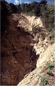
. The rainfall also caused widespread mudslides across the mountainous country.
President of Honduras
This page lists the Presidents of Honduras.Colonial Honduras declared its independence from Spain on 15 September 1821. From 5 January 1822 to 1 July 1823, Honduras was part of the First Mexican Empire of Agustín de Iturbide....
Carlos Roberto Flores
Carlos Roberto Flores
Carlos Roberto Flores Facussé was President of Honduras from 27 January 1998 to 27 January 2002 and President of the National Congress from 25 January 1994 to 25 January 1998.- Biography :...
claimed it destroyed fifty years of progress in the country. An estimated 70–80% of the transportation infrastructure of the entire country was wiped out, including nearly all bridges and secondary roads; the damage was so great that existing maps were rendered obsolete. About 25 small villages were reported to have been entirely destroyed by the landslides caused by the storm. Damages to the transportation and communication network totaled to $529 million (1998 USD, $718 million 2011 USD). Across the country, the storm destroyed 33,000 houses and damaged 50,000 others. In addition, it downed numerous trees, leaving mountainsides bare and more vulnerable to mudslides.
National Climatic Data Center
The United States National Climatic Data Center in Asheville, North Carolina is the world's largest active archive of weather data. The center became established in late 1951, with the move into the new facility occurring in early 1952....
estimated the flooding destroyed at least 70% of the country's crops. Food crops were severely impacted, including destruction of 58% of the corn output, 24% of sorghum, 14% of rice, and 6% of the bean crop. Several important export crops faced similar losses, including 85% of banana, 60% of sugar cane, 29% of melons, 28% of African palms, and 18% of coffee. Crop damage alone was estimated anywhere from $900 million (1998 USD, $1.22 billion 2011 USD) to $1.7 billion (1998 USD, $2.31 billion 2011 USD). Large amounts of animal losses occurred as well, including the death of 50,000 cattle and the loss of 60% of the poultry population. Shrimp production, which had become an important export, faced nearly complete destruction. Total animal losses amounted to $300 million (1998 USD, $407 million 2011 USD).
The extreme flooding and mudslides killed over 6,500, with several thousand missing. Many of the unidentified were buried in mass graves, resulting in great uncertainty over the final death toll. Over 20% of the country's population, possibly as many as 1.5 million people, were left homeless. The severe crop shortages left many villages on the brink of starvation, while lack of sanitation led to outbreaks of malaria
Malaria
Malaria is a mosquito-borne infectious disease of humans and other animals caused by eukaryotic protists of the genus Plasmodium. The disease results from the multiplication of Plasmodium parasites within red blood cells, causing symptoms that typically include fever and headache, in severe cases...
, dengue fever
Dengue fever
Dengue fever , also known as breakbone fever, is an infectious tropical disease caused by the dengue virus. Symptoms include fever, headache, muscle and joint pains, and a characteristic skin rash that is similar to measles...
, and cholera
Cholera
Cholera is an infection of the small intestine that is caused by the bacterium Vibrio cholerae. The main symptoms are profuse watery diarrhea and vomiting. Transmission occurs primarily by drinking or eating water or food that has been contaminated by the diarrhea of an infected person or the feces...
.
On the offshore island of Guanaja
Guanaja
Guanaja is one of the Bay Islands of Honduras, and is in the Caribbean. It is about 70 km off the north coast of Honduras, and 12 km from the island of Roatan. One of the cays off Guanaja, also called Guanaja or Bonnaca or Low Cay , is near the main island, and contains most of the...
, the hurricane spent three days stalling near the island. Strong winds destroyed one third of the island's houses and left most citizens without power for months. The island's two fish packing plants were damaged while two main resorts were closed. Guanaja received little help from the national government, being a small (9 miles long, 14 km) island which has traditionally had an independent and self-reliant streak. Instead, international aid arrived from former Guanaja citizens, enough those citizens from the mainland came to the island to acquire supplies. In all, at least 7,000 were reported dead and damage was pegged at $3.8 billion in Honduras.
Nicaragua
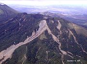
Nicaragua
Nicaragua is the largest country in the Central American American isthmus, bordered by Honduras to the north and Costa Rica to the south. The country is situated between 11 and 14 degrees north of the Equator in the Northern Hemisphere, which places it entirely within the tropics. The Pacific Ocean...
, its large circulation caused extensive rainfall, with estimates of over 50 inches (127 cm). In some places, as much as 25 inches (64 cm) of rain fell on coastal areas. The flank of the Casita
Geography of Nicaragua
Nicaragua is a country in Central America, bordering both the Caribbean Sea and the North Pacific Ocean, between Costa Rica and Honduras. Approximately the size of Greece or the U.S. state of New York, it is the largest country in Central America...
Volcano failed and turned into a lahar
Lahar
A lahar is a type of mudflow or debris flow composed of a slurry of pyroclastic material, rocky debris, and water. The material flows down from a volcano, typically along a river valley. The term is a shortened version of "berlahar" which originated in the Javanese language of...
from excessive rain. The resulting mudslide
Landslide
A landslide or landslip is a geological phenomenon which includes a wide range of ground movement, such as rockfalls, deep failure of slopes and shallow debris flows, which can occur in offshore, coastal and onshore environments...
ultimately covered an area 10 miles (16 km) long and 5 miles (8 km) wide.
Two million people in Nicaragua were directly affected by the hurricane. Across the country, Mitch's heavy rains damaged 17,600 houses and destroyed 23,900, displacing 368,300 of the population. 340 schools and 90 health centers were severely damaged or destroyed. Sewage systems and the electricity subsector were severely damaged, and, combined with property, damage totaled to $300 million (1998 USD, $407 million 2011 USD).
Pan-American Highway
The Pan-American Highway is a network of roads measuring about in total length. Except for an rainforest break, called the Darién Gap, the road links the mainland nations of the Americas in a connected highway system. According to Guinness World Records, the Pan-American Highway is the world's...
. Total transportation damage amounted to $300 million (1998 USD, $407 million 2011 USD). Agricultural losses were significant, including the deaths of 50,000 animals, mostly bovines. Crops and fisheries were affected greatly as well, and, combined with agricultural losses, damage totaled to $185 million (1998 USD, $251 million 2011 USD).
The situation was further compounded by a total of 75,000 live land mine
Land mine
A land mine is usually a weight-triggered explosive device which is intended to damage a target—either human or inanimate—by means of a blast and/or fragment impact....
s—left over from the Contra insurgency of the 1980s—that were calculated to have been uprooted and relocated by the floodwaters.
In all, Hurricane Mitch caused at least 3,800 fatalities in Nicaragua, of which more than 2,000 were killed in the towns of El Provenir and Rolando Rodriguez from the landslide at the Casita volcano. The mudslide buried at least four villages completely in several feet of mud. Throughout the entire country, the hurricane left between 500,000 and 800,000 homeless. In all, damage in Nicaragua is estimated at around $1 billion (1998 USD, $1.36 billion 2011 USD).
Caribbean Sea
Mitch was also responsible for the loss of the Fantome windjammerWindjammer
A windjammer is the ultimate type of large sailing ship with an iron or for the most part steel hull, built to carry cargo in the late nineteenth and early twentieth century...
sailing ship owned by Windjammer Barefoot Cruises
Windjammer Barefoot Cruises
Windjammer Barefoot Cruises was a leisure cruise line based in Miami Beach, Florida. Founded in 1947, the company scheduled one and two week cruises in the Caribbean and Central America, using a fleet of sailing ships. The ships were former yachts and commercial vessels that were refurbished as...
; all 31 of the crew perished. The story was recorded in the book The Ship and The Storm by Jim Carrier. The ship, which was sailing near the center of the hurricane, experienced over 50 foot (15 m) waves and over 100 mph (160 km/h) winds, causing the Fantome to sink off the coast of Honduras.
On the south coast of Cuba
Cuba
The Republic of Cuba is an island nation in the Caribbean. The nation of Cuba consists of the main island of Cuba, the Isla de la Juventud, and several archipelagos. Havana is the largest city in Cuba and the country's capital. Santiago de Cuba is the second largest city...
, the hurricane caused waves of up to 13 feet (4 m) high and winds gusts peaking at 42 mph (67 km/h), causing numerous tourists and workers on the Isle of Youth and Cayo Largo del Sur
Cayo Largo del Sur
Cayo Largo del Sur, also known simply as Cayo Largo, cayo largo means largo island, is a small resort island belonging to Cuba, in the Caribbean Sea no more than long and wide...
to leave for safer grounds.
In Jamaica
Jamaica
Jamaica is an island nation of the Greater Antilles, in length, up to in width and 10,990 square kilometres in area. It is situated in the Caribbean Sea, about south of Cuba, and west of Hispaniola, the island harbouring the nation-states Haiti and the Dominican Republic...
, where officials declared hurricane warnings 12 hours prior to its closest approach, Mitch caused moderate rainfall and gusty winds for days. Strong waves hit western Jamaica, with wave heights unofficially estimated at nearly 7 feet (2 m) in height. The rainfall in outer rainbands, at times severe, flooded many roads across the island and left them covered with debris. One house in Spanish Town
Spanish Town
Spanish Town is the capital and the largest town in the parish of St. Catherine in the county of Middlesex, Jamaica. It was the former Spanish and English capital of Jamaica from the 16th to the 19th century...
collapsed from the flooding, leaving four homeless. Many other homes and buildings were flooded, forcing many to evacuate. A river in northeastern Jamaica overflowed its banks, while heavy rainfall across the mountainous parts of the country caused numerous mudslides. In all, Mitch killed three people on Jamaica.
On the Cayman Islands
Cayman Islands
The Cayman Islands is a British Overseas Territory and overseas territory of the European Union located in the western Caribbean Sea. The territory comprises the three islands of Grand Cayman, Cayman Brac, and Little Cayman, located south of Cuba and northwest of Jamaica...
, the hurricane caused strong waves, gusty winds, and heavy rainfall at times. Damage was relatively minimal, amounting to blown out windows and beach erosion. Strong waves damaged or destroyed many docks on the south shore of the islands, and also sank one dive ship near Grand Cayman
Grand Cayman
Grand Cayman is the largest of the three Cayman Islands and the location of the nation's capital, George Town. In relation to the other two Cayman Islands, it is approximately 75 miles southwest of Little Cayman and 90 miles southwest of Cayman Brac.-Geography:Grand Cayman encompasses 76% of...
. In addition, numerous incoming and outgoing flights were cancelled.
Rest of Central America
Due to Mitch's large circulation, it dropped heavy precipitation as far south as PanamaPanama
Panama , officially the Republic of Panama , is the southernmost country of Central America. Situated on the isthmus connecting North and South America, it is bordered by Costa Rica to the northwest, Colombia to the southeast, the Caribbean Sea to the north and the Pacific Ocean to the south. The...
, especially in the Darién
Darién Province
Darién is a province in eastern Panama. It is also the largest province in Panama. It is hot, humid, heavily forested, and sparsely populated, having 48,378 habitants...
and Chiriquí
Chiriquí Province
Chiriquí is a province of Panama, it is located on the western coast of Panama, and it is also the second most developed province in the country, after the Panamá Province. Its capital is the city of David. It has a total area of 6,490.9 km², with a population of 416,873 as of the year 2010...
provinces. The flooding washed away a few roads and bridges, and damaged numerous houses and schools, leaving thousands homeless. The hurricane left three casualties in Panama.
In Costa Rica
Costa Rica
Costa Rica , officially the Republic of Costa Rica is a multilingual, multiethnic and multicultural country in Central America, bordered by Nicaragua to the north, Panama to the southeast, the Pacific Ocean to the west and the Caribbean Sea to the east....
, Mitch dropped heavy rains, causing flash flooding and mudslides across the country, mostly in the northeastern part of the country. The storm impacted 2,135 homes to some degree, of which 242 were destroyed, leaving 4,000 homeless. Throughout the country, the rainfall and mudslides affected 126 bridges and 800 miles (1300 km) or roads, mostly on the Inter-American Highway
Pan-American Highway
The Pan-American Highway is a network of roads measuring about in total length. Except for an rainforest break, called the Darién Gap, the road links the mainland nations of the Americas in a connected highway system. According to Guinness World Records, the Pan-American Highway is the world's...
which was affected by Hurricane Cesar
Hurricane Cesar-Douglas
Hurricane Cesar–Douglas was a devastating tropical cyclone that killed 122 people throughout Central and South America in late-July 1996. The Category 1 hurricane formed in late July in the Caribbean Sea and pounded Central America with rain, killing 67 people and causing local governments to deem...
, two years prior. Mitch affected 115 sq. miles (300 km2) of crop lands, causing damage to both export and domestic crops. In all, Hurricane Mitch caused $92 million in damage (1998 USD, $124.9 million 2011 USD) and seven deaths.
While drifting through El Salvador
El Salvador
El Salvador or simply Salvador is the smallest and the most densely populated country in Central America. The country's capital city and largest city is San Salvador; Santa Ana and San Miguel are also important cultural and commercial centers in the country and in all of Central America...
, the hurricane dropped immense amounts of precipitation, resulting in flash flooding and mudslides through the country. Multiple rivers, including the Río Grande de San Miguel
Río Grande de San Miguel
Río Grande de San Miguel is a river in southern El Salvador. It empties to the Pacific Ocean in the Usulután Department at ....
and the Lempa River
Lempa River
The Lempa River is a 422 km long river in Central America. Its sources are located in between the Sierra Madre and the Sierra del Merendón in southern Guatemala, near the town of Olopa. In Guatemala the river is called Río Olopa and flows southwards for 30.4 km before entering Honduras and...
overflowed, contributing to overall damage. The flooding damaged more than 10,000 houses, leaving around 84,000 homeless and forcing 500,000 to evacuate. Crop damage was severe, with serious flooding occurring on 386 sq. miles (1000 km2) of pasture or crop land. The flooding destroyed 37% of the bean production, 19% of the corn production, and 20% losses in sugar canes. There were heavy losses in livestock as well, including the deaths of 10,000 cattle. Total agricultural and livestock damaged amounted to $154 million (1998 USD, $209 million 2011 USD). In addition, the flooding destroyed two bridges and damaged 1,200 miles (2000 km) of unpaved roads. In all, Mitch caused nearly $400 million in damage (1998 USD, $543 million 2011 USD) and 240 deaths.
Similar to the rest of Central America, Mitch's heavy rains caused mudslides and severe flooding over Guatemala
Guatemala
Guatemala is a country in Central America bordered by Mexico to the north and west, the Pacific Ocean to the southwest, Belize to the northeast, the Caribbean to the east, and Honduras and El Salvador to the southeast...
. The flooding destroyed 6,000 houses and damaged 20,000 others, displacing over 730,000 and forcing over 100,000 to evacuate. In addition, the flooding destroyed 27 schools and damaged 286 others, 175 severely. Flooding caused major damage to crops, while landslides destroyed crop land across the country. The most severely affected crops for domestic consumption were tomatoes, bananas, corn, other vegetables, and beans, with damaged totaling to $48 million (1998 USD, $65 million 2011 USD). Export crops such as bananas or coffee were greatly damaged as well, with damage amounting to $325 million (1998 USD, $441 million 2011 USD). Damage to plantations and soil totaled to $121 million (1998 USD, $164 million 2011 USD). The flooding also caused severe damage to the transportation infrastructure, including the loss of 37 bridges. Across the country, flooding damaged or destroyed 840 miles (1350 km) of roads, of which nearly 400 miles (640 km) were sections of major highways. In all, Hurricane Mitch caused $748 million (1998 USD, $1.02 billion 2011 USD) and 268 deaths in Guatemala. In addition, Mitch caused 11 indirect deaths when a plane crashed during the storm.
In Belize
Belize
Belize is a constitutional monarchy and the northernmost country in Central America. Belize has a diverse society, comprising many cultures and languages. Even though Kriol and Spanish are spoken among the population, Belize is the only country in Central America where English is the official...
, the hurricane was less severe than initially predicted, though Mitch still caused heavy rainfall across the country. Numerous rivers exceeded their crests, though the rainfall was beneficial to trees in mountainous areas. The flooding caused extensive crop damage and destroyed many roads. Throughout the country, eleven people died because of the hurricane.
Mexico
The United Mexican States , commonly known as Mexico , is a federal constitutional republic in North America. It is bordered on the north by the United States; on the south and west by the Pacific Ocean; on the southeast by Guatemala, Belize, and the Caribbean Sea; and on the east by the Gulf of...
, Mitch produced gusty winds and heavy rains on the Yucatán Peninsula
Yucatán Peninsula
The Yucatán Peninsula, in southeastern Mexico, separates the Caribbean Sea from the Gulf of Mexico, with the northern coastline on the Yucatán Channel...
, with Cancún
Cancún
Cancún is a city of international tourism development certified by the UNWTO . Located on the northeast coast of Quintana Roo in southern Mexico, more than 1,700 km from Mexico City, the Project began operations in 1974 as Integrally Planned Center, a pioneer of FONATUR Cancún is a city of...
on the Quintana Roo
Quintana Roo
Quintana Roo officially Estado Libre y Soberano de Quintana Roo is one of the 31 states which, with the Federal District, comprise the 32 Federal Entities of Mexico. It is divided in 10 municipalities and its capital city is Chetumal....
coast being the worst hit. Nine people were killed from the flooding, though damage was relatively minimal. The maximum 24 hour rainfall total from Mitch was 13.4 inches (340.4 mm) in Campeche
Campeche, Campeche
San Francisco de Campeche is the capital city of the Mexican state of Campeche, located at,...
, while the highest rainfall total was 16.85 inches (428 mm) in Ciudad del Carmen
Ciudad del Carmen
Ciudad del Carmen is a city in the southwest of the Mexican state of Campeche. Ciudad del Carmen is located at on the southwest of Carmen Island, which stands in the Laguna de Términos on the coast of the Gulf of Mexico. The 2005 census population was 154,197 people...
.
Florida
Then a tropical storm, Mitch caused a storm surge of up to four feet in the lower Florida KeysFlorida Keys
The Florida Keys are a coral archipelago in southeast United States. They begin at the southeastern tip of the Florida peninsula, about south of Miami, and extend in a gentle arc south-southwest and then westward to Key West, the westernmost of the inhabited islands, and on to the uninhabited Dry...
before making landfall on the Florida
Florida
Florida is a state in the southeastern United States, located on the nation's Atlantic and Gulf coasts. It is bordered to the west by the Gulf of Mexico, to the north by Alabama and Georgia and to the east by the Atlantic Ocean. With a population of 18,801,310 as measured by the 2010 census, it...
west coast. Key West International Airport
Key West International Airport
Key West International Airport is a county-owned public airport located two miles east of the central business district of Key West, in Monroe County, Florida, United States....
reported peak wind gusts of 55 mph (89 km/h) and sustained winds of 40 mph (64 km/h), the only report of tropical storm force in the state. Offshore, the Fowey Rocks Light
Fowey Rocks Light
Fowey Rocks Light is located seven miles southeast of Cape Florida on Key Biscayne. The lighthouse was completed in 1878, replacing the Cape Florida lighthouse. It was automated on May 7, 1974 and is still in operation today. The structure is cast iron, with a screw-pile foundation, a platform and...
reported a wind gusts of 73 mph (117.5 km/h). In addition, Mitch caused moderate rainfall, peaking at 7 inches (18 cm) in Jupiter
Jupiter, Florida
Jupiter is a town located in Palm Beach County, Florida. As of the 2000 census, the town had a total population of 39,328. The estimate population for 2009 is 50,606. As of 2006, the population had grown to 50,028, according to the University of Florida, Bureau of Economic and Business Research....
, though some estimates indicate localized totals of up to 10 inches (25 cm). The storm spawned five tornadoes over the state, the strongest of which was an F2
Fujita scale
The Fujita scale , or Fujita-Pearson scale, is a scale for rating tornado intensity, based primarily on the damage tornadoes inflict on human-built structures and vegetation...
.
In the Florida Keys, multiple buildings that had been damaged by Hurricane Georges
Hurricane Georges
Hurricane Georges was a very destructive, powerful and long-lived Cape Verde-type Category 4 hurricane. Georges was the seventh tropical storm, fourth hurricane, and second major hurricane of the 1998 Atlantic hurricane season...
were leveled by Mitch. Tornadoes from the storm damaged or destroyed 645 houses across the state, in addition to injuring 65 people. Gusty winds left 100,000 without power during the storm's passage. In all, Mitch caused $40 million in damage (1998 USD, $54.3 million 2011 USD) in Florida and two deaths from drowning when two boats capsized.
Aftermath
Because of the hurricane's destruction in Central America
Central America
Central America is the central geographic region of the Americas. It is the southernmost, isthmian portion of the North American continent, which connects with South America on the southeast. When considered part of the unified continental model, it is considered a subcontinent...
and elsewhere in North America, the World Meteorological Organization
World Meteorological Organization
The World Meteorological Organization is an intergovernmental organization with a membership of 189 Member States and Territories. It originated from the International Meteorological Organization , which was founded in 1873...
retired the name Mitch in the spring of 1999; it will never again be used for an Atlantic hurricane. The name was replaced with Matthew
Tropical Storm Matthew (2004)
Tropical Storm Matthew was a weak tropical storm in the 2004 Atlantic hurricane season that made landfall on Louisiana. Matthew was the thirteenth tropical storm of the season and the ninth storm to affect the United States. Matthew formed over the western Gulf of Mexico on October 8 and struck...
in the 2004 season
2004 Atlantic hurricane season
The 2004 Atlantic hurricane season officially began on June 1, 2004, and lasted until November 30, 2004. These dates conventionally delimit the period of each year when most tropical cyclones form in the Atlantic basin...
.
After the disaster caused by Hurricane Mitch, countries around the world donated significant aid, totaling $6.3 billion (1998 USD, $8.6 billion 2011 USD). Throughout Central America
Central America
Central America is the central geographic region of the Americas. It is the southernmost, isthmian portion of the North American continent, which connects with South America on the southeast. When considered part of the unified continental model, it is considered a subcontinent...
, which was recovering from an economic crisis that occurred in 1996, many wished to continue the growth of the infrastructure and economy. In addition, after witnessing the vulnerability to hurricanes, the affected governments endeavored to prevent such a disaster from occurring again.
Hundreds of thousands of people lost their homes, but many took this as an opportunity to rebuild stronger houses. With a new, structurally improved foundation, homes were redesigned to be able to withstand another hurricane. However, lack of arable crop land took away the jobs from many, decreasing an already low income even lower.
Following the passage of Mitch, disease outbreaks occurred throughout Central America, including cholera
Cholera
Cholera is an infection of the small intestine that is caused by the bacterium Vibrio cholerae. The main symptoms are profuse watery diarrhea and vomiting. Transmission occurs primarily by drinking or eating water or food that has been contaminated by the diarrhea of an infected person or the feces...
, leptospirosis
Leptospirosis
Leptospirosis is caused by infection with bacteria of the genus Leptospira, and affects humans as well as other mammals, birds, amphibians, and reptiles.The...
, and dengue fever
Dengue fever
Dengue fever , also known as breakbone fever, is an infectious tropical disease caused by the dengue virus. Symptoms include fever, headache, muscle and joint pains, and a characteristic skin rash that is similar to measles...
. Over 2,328 cases of cholera were reported, killing 34 people. Guatemala was most affected by the bacterium, where most of the deaths occurred from contaminated food. 450 cases of leptospirosis were reported in Nicaragua, killing seven people. There were over 1,357 cases of dengue reported, though no deaths were reported from the disease.
Coral reef
Coral reefs are underwater structures made from calcium carbonate secreted by corals. Coral reefs are colonies of tiny living animals found in marine waters that contain few nutrients. Most coral reefs are built from stony corals, which in turn consist of polyps that cluster in groups. The polyps...
s. Later, the storm's immense rainfall led to runoff polluted with debris and fresh water. This resulted in diseases occurring within the coral. However, the hurricane's upwelling cooled the warm water temperatures, preventing significant bleaching and destruction of the coral reef.
Honduras, the country most affected by the hurricane, received significant aid for the millions impacted by the hurricane. Mexico quickly gave help, sending 700 tons of food, 11 tons of medicine, four rescue planes, rescue personnel, and trained search dogs. Cuba also volunteered, sending a contingent of physicians to the country. The U.S. administration offered at first troops stationed in Honduras, and then withdrew them a few days after the storm. They also at first offered only $2 million (1998 USD, $2.7 million 2011 USD) in aid, which came as a shock to residents, and president Carlos Roberto Flores alike. The U.S. later increased their offer to $70 million (1998 USD, $95 million 2011 USD). The Honduran government distributed food, water, and medical services to the hurricane victims, including the more than 4 million without water. President Flores turned the administration of the relief efforts to the church, both Protestant and Catholic. The relief effort was carried out with virtually no incidents; only one truck was discovered to be re-routed for personal use, and the person responsible for this was subsequently punished. In addition, the country initially experienced a sharp increase in the unemployment rate, largely due to the destruction of crop lands. However, rebuilding provided jobs in the following years. In Costa Rica
Costa Rica
Costa Rica , officially the Republic of Costa Rica is a multilingual, multiethnic and multicultural country in Central America, bordered by Nicaragua to the north, Panama to the southeast, the Pacific Ocean to the west and the Caribbean Sea to the east....
, reconstruction after the hurricane increased the number of jobs by 5.9%, lowering the unemployment rate slightly.
See also
- List of Category 5 Atlantic hurricanes
- List of deadliest Atlantic hurricanes
- List of retired Atlantic hurricane names
- List of wettest tropical cyclones by country – Mitch was one of the wettest known tropical cyclones for Central America