Encyclopedia
The
Galveston Hurricane of 1900 made landfall on the city of
Galveston,
Texas
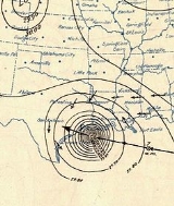
, on September 8, 1900. It had estimated winds of 135 miles per hour at landfall, making it a Category 4 storm on the Saffir-Simpson Hurricane Scale.
The
hurricane caused great loss of life. The death toll has been estimated to be between 6,000 and 12,000 individuals, depending on whether one counts casualties from the city of Galveston itself, the larger island, or the region as a whole. The number most cited in official reports is 8,000, giving the storm the third-highest number of casualties of any
Atlantic hurricane, after the Great Hurricane of 1780, and 1998's
Hurricane Mitch. The Galveston Hurricane of 1900 is to date the deadliest natural disaster ever to strike the
United States. By contrast, the second-deadliest storm to strike the United States, the
1928 Okeechobee Hurricane, caused approximately 2,500 deaths, and the deadliest storm of recent times,
Hurricane Katrina, has caused approximately 1,600 deaths.
The hurricane has no official name and is referred to under various descriptive, unofficial names. Common names for the storm include the
Galveston Hurricane of 1900, the
Great Galveston Hurricane, and in older documentation, the
Galveston Flood. It is often locally known in the Galveston area as
The Great Storm .
The city
The city of Galveston at the end of the 19th century was a booming
metropolis with a population of 42,000. Its position on the natural
harbor of Galveston Bay along the
Gulf of Mexico made it the center of trade and the biggest city in the state of
Texas. With this prosperity came a sense of complacency.
A quarter of a century earlier, the nearby town of
Indianola on Matagorda Bay was undergoing its own boom and was second to Galveston among Texas
ports. Then in 1875, a powerful hurricane blew through, nearly destroying the town. Indianola was rebuilt, but a
second hurricane in 1886 caused residents to simply give up and move elsewhere.
Many Galveston residents took the destruction of Indianola as an object lesson on the threat posed by hurricanes. Galveston was a low, flat
island, little more than a giant
sandbar along the
gulf coast. They called for a
seawall to be constructed to protect the city, but their concerns were dismissed by the majority of the population and the city's government.
Since its formal founding in 1839, the city of Galveston had weathered numerous storms, which the city survived with ease. Residents believed any future storms would be no worse than previous events. In order to provide an official
meteorological statement on the threat of hurricanes, Galveston Weather Bureau section director
Isaac Cline wrote an 1891 article in the
Galveston News in which he argued not only that a seawall was not needed to protect the city, but that it would be impossible for a hurricane of significant strength to strike the island.
The seawall was not built, and development activities on the island actively increased its vulnerability to storms. Sand dunes along the shore were cut down to fill low areas in the city, removing what little barrier there was to the Gulf of Mexico.
Origins
The storm's origins are unclear, due to the limited observation ability at the end of the 19th century. Ship reports were the only reliable tool for observing hurricanes at sea, and because wireless telegraphy was in its infancy, these reports were not available until the ships put in at a harbor.
Like most powerful Atlantic hurricanes, the 1900 storm is believed to have begun as a
Cape Verde-type hurricane—a tropical wave moving off the western coast of
Africa. The first formal sighting of the hurricane's precursor occurred on August 27, about one thousand miles east of the
Windward Islands, when a ship recorded an area of "unsettled weather".
Three days later,
Antigua reported a severe
thunderstorm passing over, followed by the hot, humid calmness that often occurs after the passage of a tropical cyclone. By September 1, U.S. Weather Bureau observers were reporting on a "storm of moderate intensity " southeast of
Cuba.
Warning signs
On September 4, the Galveston office of the
U.S. Weather Bureau began receiving warnings from the Bureau's central office in
Washington, D.C., that a "tropical storm" had moved northward over Cuba. The Weather Bureau forecasters had no way of knowing where the storm was or where it was going.
Conditions in the
Gulf of Mexico were ripe for further strengthening of the storm. The Gulf had seen little cloud cover for several weeks, and the seas were as warm as bathwater, according to one report. For a storm system that feeds off moisture, the Gulf of Mexico was enough to boost the storm from a tropical storm to a hurricane in a matter of days, with further strengthening likely.
The storm was reported to be north of
Key West on September 6, and in the early morning hours of Friday, September 7, the Weather Bureau office in
New Orleans, Louisiana, issued a report of heavy damage along the
Louisiana and
Mississippi coasts. Details of the storm were not widespread; damage to telegraph lines limited communication. The Bureau's central office in
Washington, D.C., ordered storm warnings raised from
Pensacola, Florida, to Galveston.
By the afternoon of the 7th, large swells from the southeast were observed on the Gulf, and clouds at all altitudes began moving in from the northeast. Both of these observations are consistent with a hurricane approaching from the east. The Galveston Weather Bureau office raised its double square flags; a hurricane warning was in effect.
The ship
Louisiana encountered the hurricane at 1 p.m. that day after departing
New Orleans. Captain Halsey estimated wind speeds of 150 mph .
Weather Bureau forecasters believed the storm would travel northeast and affect the mid-Atlantic coast. "To them, the storm appeared to have begun a long turn or 'recurve' that would take it first into Florida, then drive it northeast toward an eventual exit into the Atlantic." Cuban forecasters disagreed, saying the hurricane would continue west. One Cuban forecaster predicted the hurricane would continue into central Texas near
San Antonio.
Early the next morning, the swells continued despite only partly cloudy skies. Largely because of the unremarkable weather, few residents heeded the warning. Few people evacuated across Galveston's bridges to the mainland, and the majority of the population was unconcerned by the rain clouds that had begun rolling in by mid-morning.
Isaac Cline claimed that he took it upon himself to travel along the beach and other low-lying areas warning people personally of the storm's approach. This is based on Cline's own reports and has been called into question in recent years, as no other survivors corroborated his account.
Cline's role in the disaster is the subject of some controversy. Supporters point to Cline's issuing a hurricane warning without permission from the Bureau's central office. Detractors point to Cline's earlier insistence that a seawall was unnecessary and his belief that an intense hurricane could not strike the island.
The storm
The last train to reach Galveston left
Houston on the morning of the September 8 at 9:45 a.m. It found the tracks washed out, and passengers were forced to transfer to a relief train on parallel tracks to complete their journey. Even then, debris on the track kept the train's progress at a crawl.
The ninety-five travelers on the train from Beaumont were not so lucky. They found themselves at the Bolivar Peninsula waiting for the ferry that would carry them, train and all, to the island. When they arrived, the high seas forced the ferry captain to give up on his attempt to dock. The train attempted to return the way it had come, but rising water blocked its path.
By early afternoon, a steady northeastern wind had picked up. By 5 p.m., the Bureau office was recording sustained hurricane force winds. That night, the wind direction shifted to the east, and then to the southeast as the hurricane's eye began to pass over the island.
One of the last messages that reached the mainland was from Cline at 3:30 p.m., reporting "Gulf rising, water covers streets of about half of city."highest measured wind speed was 100 mph just after 6 p.m., but the Weather Bureau's
anemometer was blown off the building shortly after that measurement. The lowest recorded
barometric pressure was 28.48 inHg age:Galveston - 1900 homes.jpg|thumb|left|Homes in Galveston such as this one were reduced to timbers by the hurricane winds and floods.]]
At the Point Bolivar lighthouse, ten refugees from the Beaumont train took refuge with two hundred residents of Port Bolivar. The eighty-five that stayed with the train died when the
storm surge overran the tops of the cars.
By 11 p.m., the wind was southerly and diminishing. On Sunday morning, a 20 mph breeze off the Gulf of Mexico greeted the survivors as they put aside the terror of the storm. The skies were clear as they realized what horror the cleanup would be.
The storm continued on, and was tracked into
Oklahoma. From there, it continued over the
Great Lakes while still sustaining winds of almost 40 mph recorded over Milwaukee, WI, and passed north of
Halifax, Nova Scotia, on September 12. From there it travelled into the
North Atlantic where it disappeared from observations. struction
At the time of the 1900 storm, the highest point in the city of Galveston was only 8.7 feet above sea level. Funeral pyres were set up wherever the dead were found. In the aftermath of the storm, pyres burned for weeks. Authorities had to pass out free whiskey to the work crews that were having to throw the bodies of their wives and children on the burn piles.
Modern observation and forecasting help ensure that if another storm of similar strength threatens Galveston, the city will not be caught by surprise.
Quotations
- "Nature will win if we decide that we can beat it."
— Bill Read, NWS Galveston, Isaac's Storm documentary
See also
References
Online
Print
- Bixel, Patricia Bellis & Turner, Elizabeth Hayes. Galveston and the 1900 Storm: Catastrophe and catalyst . University of Texas Press ISBN 0-292-70883-1
- Larson, Erik. Isaac's Storm: A Man, A Time, and the Deadliest Hurricane in History . New York:Crown Publishers. ISBN 0-609-60233-0
Notes
External links
- from the Galveston and Texas History Center at the Rosenberg Library
-
- Primary Source Adventure, a lesson plan hosted by