

Historical climatology
Encyclopedia
Historical climatology is the study of historical changes in climate
and their effect on human history and development. This differs from paleoclimatology
which encompasses climate change over the entire history of the earth. The study seeks to define periods in human history where temperature or precipitation
varied from what is observed in the present day. The primary sources include written records such as sagas
, chronicles
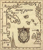
, maps
and local history
literature as well as pictorial representations such as painting
s, drawing
s and even rock art
. The archaeological record is equally important in establishing evidence of settlement, water and land usage.
records of natural processes, for example viticultural
records of grape harvest dates. In preliterate or non-literate societies, researchers must rely on other techniques to find evidence of historical climate differences.
Past population levels and habitable ranges of humans or plants and animals may be used to find evidence of past differences in climate for the region. Palynology
, the study of pollens, can show not only the range of plants and to reconstruct possible ecology, but to estimate the amount of precipitation in a given time period, based on the abundance of pollen in that layer of sediment
or ice.
, 70,000 to 75,000 years ago reduced the average global temperature by 5 degrees Celsius for several years and may have triggered an ice age. It has been postulated that this created a bottleneck in human evolution. A much smaller but similar effect occurred after the eruption of Krakatoa
in 1883, when global temperatures fell for about 5 years in a row.
Before the retreat of glacier
s at the start of the Holocene
(~9600 BC), ice sheet
s covered much of the northern latitude
s and sea level
s were much lower than they are today. The start of our present interglacial
period appears to have helped spur the development of human civilization
.
 Evidence of a warm climate in Europe, for example, comes from archaeological studies of settlement and farming in the Early Bronze Age at altitude
s now beyond cultivation, such as Dartmoor
, Exmoor
, the Lake district
and the Pennines
in England
. The climate appears to have deteriorated towards the Late Bronze Age however. Settlements and field boundaries have been found at high altitude in these areas, which are now wild and uninhabitable. They include Dartmoor
and Exmoor
as well as the Pennines
and Lake District
in the United Kingdom
. Grimspound
on Dartmoor is well preserved and shows the standing remains of an extensive settlement in a now inhospitable environment.
Some parts of the present Sahara
n desert may have been populated when the climate was cooler and wetter, judging by cave art and other signs of settlement in Prehistoric Central North Africa
.
The Medieval Warm Period
was a time of warm weather between about AD 800–1300, during the European Medieval period.
Archaeological evidence supports studies of the Norse sagas whuich describe the settlement of Greenland
in the 9th century AD of land now quite unsuitable for cultivation. For example, excavations at one settlement site have shown the presence of birch trees during the early Viking period. The same period records the discovery of an area called Vinland
, probably in North America, which may also have been warmer than at present, judging by the alleged presence of grape vines. The interlude is known as the Medieval Warm Period
.
, well documented by paintings, documents (such as diaries) and events such as the River Thames frost fairs
held on frozen lakes and rivers in the 17th and 18th centuries. The River Thames
was made more narrow and flowed faster after old London Bridge
was demolished in 1831, and the river was embanked in stages during the 19th century, both of which made the river less liable to freezing. Among the earliest references to the coming climate change is an entry in the Anglo-Saxon Chronicle
s dated 1046:
The Chronicle is the single most important historical source for the period in England between the departure of the Romans and the decades following the Norman Conquest. Much of the information given in the Chronicle is not recorded elsewhere.
 The Little Ice Age brought colder winters to parts of Europe and North America. In the mid-17th century, glaciers in the Swiss Alps
advanced, gradually engulfing farms and crushing entire villages. The River Thames
and the canals and rivers of the Netherlands
often froze over during the winter, and people skated and even held frost fairs on the ice. The first Thames frost fair was in 1607; the last in 1814, although changes to the bridges and the addition of an embankment affected the river flow and depth, hence diminishing the possibility of freezes. The freeze of the Golden Horn
and the southern section of the Bosphorus took place in 1622. In 1658, a Swedish army marched across the Great Belt to Denmark to invade Copenhagen
. The Baltic Sea froze over, enabling sledge rides from Poland to Sweden, with seasonal inns built on the way. The winter of 1794/1795 was particularly harsh when the French invasion army under Pichegru could march on the frozen rivers of the Netherlands, while the Dutch fleet was fixed in the ice in Den Helder harbour. In the winter of 1780, New York
Harbour froze, allowing people to walk from Manhattan
to Staten Island
. Sea ice surrounding Iceland
extended for miles in every direction, closing that island's harbours to shipping.
 The severe winters affected human life in ways large and small. The population of Iceland fell by half, but this was perhaps also due to fluorosis caused by the eruption of the volcano Laki in 1783.Iceland also suffered failures of cereal crops and people moved away from a grain-based diet. The Norse colonies in Greenland starved and vanished (by the 15th century) as crops failed and livestock could not be maintained through increasingly harsh winters, though Jared Diamond
noted that they had exceeded the agricultural carrying capacity before then. In North America, American Indians formed leagues in response to food shortages. In Southern Europe, in Portugal, snow storms were much more frequent while today they are rare. There are reports of heavy snowfalls in the winters of 1665, 1744 and 1886.
In contrast to its uncertain beginning, there is a consensus that the Little Ice Age ended in the mid-19th century.
, desertification
and the salinization of soils may have contributed to or caused other climatic changes throughout human history.
For a discussion of recent human involvement in climatic changes, see Attribution of recent climate change
.
Climate
Climate encompasses the statistics of temperature, humidity, atmospheric pressure, wind, rainfall, atmospheric particle count and other meteorological elemental measurements in a given region over long periods...
and their effect on human history and development. This differs from paleoclimatology
Paleoclimatology
Paleoclimatology is the study of changes in climate taken on the scale of the entire history of Earth. It uses a variety of proxy methods from the Earth and life sciences to obtain data previously preserved within rocks, sediments, ice sheets, tree rings, corals, shells and microfossils; it then...
which encompasses climate change over the entire history of the earth. The study seeks to define periods in human history where temperature or precipitation
Precipitation (meteorology)
In meteorology, precipitation In meteorology, precipitation In meteorology, precipitation (also known as one of the classes of hydrometeors, which are atmospheric water phenomena is any product of the condensation of atmospheric water vapor that falls under gravity. The main forms of precipitation...
varied from what is observed in the present day. The primary sources include written records such as sagas
Sagàs
Sagàs is a small town and municipality located in Catalonia, in the comarca of Berguedà. It is located in the geographical area of the pre-Pyrenees.-Population:...
, chronicles
Chronicles
Chronicles may refer to:* Books of Chronicles, in the Bible* Chronicle: Medieval historical histories, like those in :Category:Chronicles* Holinshed's Chronicles, the collected works of Raphael Holinshed...
, maps
MAPS
Maps is the plural of map, a visual representation of an area.As an acronym, MAPS may refer to:* Mail Abuse Prevention System, an organisation that provides anti-spam support...
and local history
Local history
Local history is the study of history in a geographically local context and it often concentrates on the local community. It incorporates cultural and social aspects of history...
literature as well as pictorial representations such as painting
Painting
Painting is the practice of applying paint, pigment, color or other medium to a surface . The application of the medium is commonly applied to the base with a brush but other objects can be used. In art, the term painting describes both the act and the result of the action. However, painting is...
s, drawing
Drawing
Drawing is a form of visual art that makes use of any number of drawing instruments to mark a two-dimensional medium. Common instruments include graphite pencils, pen and ink, inked brushes, wax color pencils, crayons, charcoal, chalk, pastels, markers, styluses, and various metals .An artist who...
s and even rock art
Rock art
Rock art is a term used in archaeology for any human-made markings made on natural stone. They can be divided into:*Petroglyphs - carvings into stone surfaces*Pictographs - rock and cave paintings...
. The archaeological record is equally important in establishing evidence of settlement, water and land usage.
Techniques of historical climatology
In literate societies, historians may find written evidence of climatic variations over hundreds or thousands of years, such as phenologicalPhenology
Phenology is the study of periodic plant and animal life cycle events and how these are influenced by seasonal and interannual variations in climate...
records of natural processes, for example viticultural
Viticulture
Viticulture is the science, production and study of grapes which deals with the series of events that occur in the vineyard. When the grapes are used for winemaking, it is also known as viniculture...
records of grape harvest dates. In preliterate or non-literate societies, researchers must rely on other techniques to find evidence of historical climate differences.
Past population levels and habitable ranges of humans or plants and animals may be used to find evidence of past differences in climate for the region. Palynology
Palynology
Palynology is the science that studies contemporary and fossil palynomorphs, including pollen, spores, orbicules, dinoflagellate cysts, acritarchs, chitinozoans and scolecodonts, together with particulate organic matter and kerogen found in sedimentary rocks and sediments...
, the study of pollens, can show not only the range of plants and to reconstruct possible ecology, but to estimate the amount of precipitation in a given time period, based on the abundance of pollen in that layer of sediment
Sediment
Sediment is naturally occurring material that is broken down by processes of weathering and erosion, and is subsequently transported by the action of fluids such as wind, water, or ice, and/or by the force of gravity acting on the particle itself....
or ice.
Evidence of climatic variations
The eruption of the Toba supervolcanoToba catastrophe theory
The Toba supereruption was a supervolcanic eruption that occurred some time between 69,000 and 77,000 years ago at Lake Toba . It is recognized as one of the Earth's largest known eruptions...
, 70,000 to 75,000 years ago reduced the average global temperature by 5 degrees Celsius for several years and may have triggered an ice age. It has been postulated that this created a bottleneck in human evolution. A much smaller but similar effect occurred after the eruption of Krakatoa
Krakatoa
Krakatoa is a volcanic island made of a'a lava in the Sunda Strait between the islands of Java and Sumatra in Indonesia. The name is used for the island group, the main island , and the volcano as a whole. The island exploded in 1883, killing approximately 40,000 people, although some estimates...
in 1883, when global temperatures fell for about 5 years in a row.
Before the retreat of glacier
Glacier
A glacier is a large persistent body of ice that forms where the accumulation of snow exceeds its ablation over many years, often centuries. At least 0.1 km² in area and 50 m thick, but often much larger, a glacier slowly deforms and flows due to stresses induced by its weight...
s at the start of the Holocene
Holocene
The Holocene is a geological epoch which began at the end of the Pleistocene and continues to the present. The Holocene is part of the Quaternary period. Its name comes from the Greek words and , meaning "entirely recent"...
(~9600 BC), ice sheet
Ice sheet
An ice sheet is a mass of glacier ice that covers surrounding terrain and is greater than 50,000 km² , thus also known as continental glacier...
s covered much of the northern latitude
Latitude
In geography, the latitude of a location on the Earth is the angular distance of that location south or north of the Equator. The latitude is an angle, and is usually measured in degrees . The equator has a latitude of 0°, the North pole has a latitude of 90° north , and the South pole has a...
s and sea level
Sea level
Mean sea level is a measure of the average height of the ocean's surface ; used as a standard in reckoning land elevation...
s were much lower than they are today. The start of our present interglacial
Interglacial
An Interglacial period is a geological interval of warmer global average temperature lasting thousands of years that separates consecutive glacial periods within an ice age...
period appears to have helped spur the development of human civilization
Civilization
Civilization is a sometimes controversial term that has been used in several related ways. Primarily, the term has been used to refer to the material and instrumental side of human cultures that are complex in terms of technology, science, and division of labor. Such civilizations are generally...
.
Human record
Altitude
Altitude or height is defined based on the context in which it is used . As a general definition, altitude is a distance measurement, usually in the vertical or "up" direction, between a reference datum and a point or object. The reference datum also often varies according to the context...
s now beyond cultivation, such as Dartmoor
Dartmoor
Dartmoor is an area of moorland in south Devon, England. Protected by National Park status, it covers .The granite upland dates from the Carboniferous period of geological history. The moorland is capped with many exposed granite hilltops known as tors, providing habitats for Dartmoor wildlife. The...
, Exmoor
Exmoor
Exmoor is an area of hilly open moorland in west Somerset and north Devon in South West England, named after the main river that flows out of the district, the River Exe. The moor has given its name to a National Park, which includes the Brendon Hills, the East Lyn Valley, the Vale of Porlock and ...
, the Lake district
Lake District
The Lake District, also commonly known as The Lakes or Lakeland, is a mountainous region in North West England. A popular holiday destination, it is famous not only for its lakes and its mountains but also for its associations with the early 19th century poetry and writings of William Wordsworth...
and the Pennines
Pennines
The Pennines are a low-rising mountain range, separating the North West of England from Yorkshire and the North East.Often described as the "backbone of England", they form a more-or-less continuous range stretching from the Peak District in Derbyshire, around the northern and eastern edges of...
in England
England
England is a country that is part of the United Kingdom. It shares land borders with Scotland to the north and Wales to the west; the Irish Sea is to the north west, the Celtic Sea to the south west, with the North Sea to the east and the English Channel to the south separating it from continental...
. The climate appears to have deteriorated towards the Late Bronze Age however. Settlements and field boundaries have been found at high altitude in these areas, which are now wild and uninhabitable. They include Dartmoor
Dartmoor
Dartmoor is an area of moorland in south Devon, England. Protected by National Park status, it covers .The granite upland dates from the Carboniferous period of geological history. The moorland is capped with many exposed granite hilltops known as tors, providing habitats for Dartmoor wildlife. The...
and Exmoor
Exmoor
Exmoor is an area of hilly open moorland in west Somerset and north Devon in South West England, named after the main river that flows out of the district, the River Exe. The moor has given its name to a National Park, which includes the Brendon Hills, the East Lyn Valley, the Vale of Porlock and ...
as well as the Pennines
Pennines
The Pennines are a low-rising mountain range, separating the North West of England from Yorkshire and the North East.Often described as the "backbone of England", they form a more-or-less continuous range stretching from the Peak District in Derbyshire, around the northern and eastern edges of...
and Lake District
Lake District
The Lake District, also commonly known as The Lakes or Lakeland, is a mountainous region in North West England. A popular holiday destination, it is famous not only for its lakes and its mountains but also for its associations with the early 19th century poetry and writings of William Wordsworth...
in the United Kingdom
United Kingdom
The United Kingdom of Great Britain and Northern IrelandIn the United Kingdom and Dependencies, other languages have been officially recognised as legitimate autochthonous languages under the European Charter for Regional or Minority Languages...
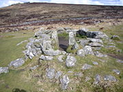
. Grimspound
Grimspound
Grimspound is a late Bronze Age settlement, situated on Dartmoor in Devon, England. It consists of a set of 24 hut circles surrounded by a low stone wall...
on Dartmoor is well preserved and shows the standing remains of an extensive settlement in a now inhospitable environment.
Some parts of the present Sahara
Sahara
The Sahara is the world's second largest desert, after Antarctica. At over , it covers most of Northern Africa, making it almost as large as Europe or the United States. The Sahara stretches from the Red Sea, including parts of the Mediterranean coasts, to the outskirts of the Atlantic Ocean...
n desert may have been populated when the climate was cooler and wetter, judging by cave art and other signs of settlement in Prehistoric Central North Africa
Prehistoric Central North Africa
- Early and middle Paleolithic :Earlier inhabitants of central North Africa have left behind equally significant remains. Early remnants of hominid occupation in North Africa, for example, were found in Ain el Hanech, near Saïda ; in fact, more recent investigations have found signs of Oldowan...
.
The Medieval Warm Period
Medieval Warm Period
The Medieval Warm Period , Medieval Climate Optimum, or Medieval Climatic Anomaly was a time of warm climate in the North Atlantic region, that may also have been related to other climate events around the world during that time, including in China, New Zealand, and other countries lasting from...
was a time of warm weather between about AD 800–1300, during the European Medieval period.
Archaeological evidence supports studies of the Norse sagas whuich describe the settlement of Greenland
Greenland
Greenland is an autonomous country within the Kingdom of Denmark, located between the Arctic and Atlantic Oceans, east of the Canadian Arctic Archipelago. Though physiographically a part of the continent of North America, Greenland has been politically and culturally associated with Europe for...
in the 9th century AD of land now quite unsuitable for cultivation. For example, excavations at one settlement site have shown the presence of birch trees during the early Viking period. The same period records the discovery of an area called Vinland
Vinland
Vinland was the name given to an area of North America by the Norsemen, about the year 1000 CE.There is a consensus among scholars that the Vikings reached North America approximately five centuries prior to the voyages of Christopher Columbus...
, probably in North America, which may also have been warmer than at present, judging by the alleged presence of grape vines. The interlude is known as the Medieval Warm Period
Medieval Warm Period
The Medieval Warm Period , Medieval Climate Optimum, or Medieval Climatic Anomaly was a time of warm climate in the North Atlantic region, that may also have been related to other climate events around the world during that time, including in China, New Zealand, and other countries lasting from...
.
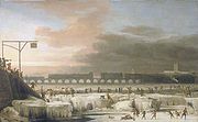
Little Ice Age
Later examples include the Little Ice AgeLittle Ice Age
The Little Ice Age was a period of cooling that occurred after the Medieval Warm Period . While not a true ice age, the term was introduced into the scientific literature by François E. Matthes in 1939...
, well documented by paintings, documents (such as diaries) and events such as the River Thames frost fairs
River Thames frost fairs
River Thames frost fairs were held on the Tideway of the River Thames at London between the 15th and 19th centuries when the river froze over. During that time the British winter was more severe than now, and the river was wider and slower....
held on frozen lakes and rivers in the 17th and 18th centuries. The River Thames
River Thames
The River Thames flows through southern England. It is the longest river entirely in England and the second longest in the United Kingdom. While it is best known because its lower reaches flow through central London, the river flows alongside several other towns and cities, including Oxford,...
was made more narrow and flowed faster after old London Bridge
London Bridge
London Bridge is a bridge over the River Thames, connecting the City of London and Southwark, in central London. Situated between Cannon Street Railway Bridge and Tower Bridge, it forms the western end of the Pool of London...
was demolished in 1831, and the river was embanked in stages during the 19th century, both of which made the river less liable to freezing. Among the earliest references to the coming climate change is an entry in the Anglo-Saxon Chronicle
Anglo-Saxon Chronicle
The Anglo-Saxon Chronicle is a collection of annals in Old English chronicling the history of the Anglo-Saxons. The original manuscript of the Chronicle was created late in the 9th century, probably in Wessex, during the reign of Alfred the Great...
s dated 1046:
- "And in this same year after the 2nd of February came the severe winter with frost and snow, and with all kinds of bad weather, so that there was no man alive who could remember so severe a winter as that, both through mortality of men and disease of cattle; both birds and fishes perished through the great cold and hunger."
The Chronicle is the single most important historical source for the period in England between the departure of the Romans and the decades following the Norman Conquest. Much of the information given in the Chronicle is not recorded elsewhere.
Swiss Alps
The Swiss Alps are the portion of the Alps mountain range that lies within Switzerland. Because of their central position within the entire Alpine range, they are also known as the Central Alps....
advanced, gradually engulfing farms and crushing entire villages. The River Thames
River Thames
The River Thames flows through southern England. It is the longest river entirely in England and the second longest in the United Kingdom. While it is best known because its lower reaches flow through central London, the river flows alongside several other towns and cities, including Oxford,...
and the canals and rivers of the Netherlands
Netherlands
The Netherlands is a constituent country of the Kingdom of the Netherlands, located mainly in North-West Europe and with several islands in the Caribbean. Mainland Netherlands borders the North Sea to the north and west, Belgium to the south, and Germany to the east, and shares maritime borders...
often froze over during the winter, and people skated and even held frost fairs on the ice. The first Thames frost fair was in 1607; the last in 1814, although changes to the bridges and the addition of an embankment affected the river flow and depth, hence diminishing the possibility of freezes. The freeze of the Golden Horn
Golden Horn
The Golden Horn is a historic inlet of the Bosphorus dividing the city of Istanbul and forming the natural harbor that has sheltered Greek, Roman, Byzantine, Ottoman and other ships for thousands of...
and the southern section of the Bosphorus took place in 1622. In 1658, a Swedish army marched across the Great Belt to Denmark to invade Copenhagen
Copenhagen
Copenhagen is the capital and largest city of Denmark, with an urban population of 1,199,224 and a metropolitan population of 1,930,260 . With the completion of the transnational Øresund Bridge in 2000, Copenhagen has become the centre of the increasingly integrating Øresund Region...
. The Baltic Sea froze over, enabling sledge rides from Poland to Sweden, with seasonal inns built on the way. The winter of 1794/1795 was particularly harsh when the French invasion army under Pichegru could march on the frozen rivers of the Netherlands, while the Dutch fleet was fixed in the ice in Den Helder harbour. In the winter of 1780, New York
New York
New York is a state in the Northeastern region of the United States. It is the nation's third most populous state. New York is bordered by New Jersey and Pennsylvania to the south, and by Connecticut, Massachusetts and Vermont to the east...
Harbour froze, allowing people to walk from Manhattan
Manhattan
Manhattan is the oldest and the most densely populated of the five boroughs of New York City. Located primarily on the island of Manhattan at the mouth of the Hudson River, the boundaries of the borough are identical to those of New York County, an original county of the state of New York...
to Staten Island
Staten Island
Staten Island is a borough of New York City, New York, United States, located in the southwest part of the city. Staten Island is separated from New Jersey by the Arthur Kill and the Kill Van Kull, and from the rest of New York by New York Bay...
. Sea ice surrounding Iceland
Iceland
Iceland , described as the Republic of Iceland, is a Nordic and European island country in the North Atlantic Ocean, on the Mid-Atlantic Ridge. Iceland also refers to the main island of the country, which contains almost all the population and almost all the land area. The country has a population...
extended for miles in every direction, closing that island's harbours to shipping.
Jared Diamond
Jared Mason Diamond is an American scientist and author whose work draws from a variety of fields. He is currently Professor of Geography and Physiology at UCLA...
noted that they had exceeded the agricultural carrying capacity before then. In North America, American Indians formed leagues in response to food shortages. In Southern Europe, in Portugal, snow storms were much more frequent while today they are rare. There are reports of heavy snowfalls in the winters of 1665, 1744 and 1886.
In contrast to its uncertain beginning, there is a consensus that the Little Ice Age ended in the mid-19th century.
Evidence of anthropogenic climate change
Through deforestation and agriculture, some scientists have proposed a human component in some historical climatic changes. Human-started fires have been implicated in the transformation of much of Australia from grassland to desert. If true, this would show that even a primitive society could have a role in influencing regional climate. DeforestationDeforestation
Deforestation is the removal of a forest or stand of trees where the land is thereafter converted to a nonforest use. Examples of deforestation include conversion of forestland to farms, ranches, or urban use....
, desertification
Desertification
Desertification is the degradation of land in drylands. Caused by a variety of factors, such as climate change and human activities, desertification is one of the most significant global environmental problems.-Definitions:...
and the salinization of soils may have contributed to or caused other climatic changes throughout human history.
For a discussion of recent human involvement in climatic changes, see Attribution of recent climate change
Attribution of recent climate change
Attribution of recent climate change is the effort to scientifically ascertain mechanisms responsible for recent changes observed in the Earth's climate...
.
See also
- ClimateClimateClimate encompasses the statistics of temperature, humidity, atmospheric pressure, wind, rainfall, atmospheric particle count and other meteorological elemental measurements in a given region over long periods...
- Little Ice AgeLittle Ice AgeThe Little Ice Age was a period of cooling that occurred after the Medieval Warm Period . While not a true ice age, the term was introduced into the scientific literature by François E. Matthes in 1939...
- Medieval Warm PeriodMedieval Warm PeriodThe Medieval Warm Period , Medieval Climate Optimum, or Medieval Climatic Anomaly was a time of warm climate in the North Atlantic region, that may also have been related to other climate events around the world during that time, including in China, New Zealand, and other countries lasting from...
- PaleoclimatologyPaleoclimatologyPaleoclimatology is the study of changes in climate taken on the scale of the entire history of Earth. It uses a variety of proxy methods from the Earth and life sciences to obtain data previously preserved within rocks, sediments, ice sheets, tree rings, corals, shells and microfossils; it then...
, the pre-historical study of EarthEarthEarth is the third planet from the Sun, and the densest and fifth-largest of the eight planets in the Solar System. It is also the largest of the Solar System's four terrestrial planets...
's climate - Global warmingGlobal warmingGlobal warming refers to the rising average temperature of Earth's atmosphere and oceans and its projected continuation. In the last 100 years, Earth's average surface temperature increased by about with about two thirds of the increase occurring over just the last three decades...
- CLIWOCCliwocThe Climatological database for the world's oceans was a research project to convert ships' logbooks into a computerised database. It was funded by the European Union, and the bulk of the work was done between 2001 and 2003...
, Climatological database for the world's oceans (1750–1854) - Temperature recordTemperature recordThe temperature record shows the fluctuations of the temperature of the atmosphere and the oceans through various spans of time. The most detailed information exists since 1850, when methodical thermometer-based records began. There are numerous estimates of temperatures since the end of the...
External links
- HistoricalClimatology.com
- Climate History Network
- US Historical Climatology Network
- Historical climatology and the cultural memory of extreme weather events - Exploring Environmental History Podcast featuring Christian Pfister