

Swiss Alps
Encyclopedia
Alps
The Alps is one of the great mountain range systems of Europe, stretching from Austria and Slovenia in the east through Italy, Switzerland, Liechtenstein and Germany to France in the west....
mountain
Mountain
Image:Himalaya_annotated.jpg|thumb|right|The Himalayan mountain range with Mount Everestrect 58 14 160 49 Chomo Lonzorect 200 28 335 52 Makalurect 378 24 566 45 Mount Everestrect 188 581 920 656 Tibetan Plateaurect 250 406 340 427 Rong River...
range
Mountain range
A mountain range is a single, large mass consisting of a succession of mountains or narrowly spaced mountain ridges, with or without peaks, closely related in position, direction, formation, and age; a component part of a mountain system or of a mountain chain...
that lies within Switzerland
Switzerland
Switzerland name of one of the Swiss cantons. ; ; ; or ), in its full name the Swiss Confederation , is a federal republic consisting of 26 cantons, with Bern as the seat of the federal authorities. The country is situated in Western Europe,Or Central Europe depending on the definition....
. Because of their central position within the entire Alpine range, they are also known as the Central Alps.
The highest summit in the Swiss Alps is Monte Rosa
Monte Rosa
The Monte Rosa Massif is a mountain massif located in the eastern part of the Pennine Alps. It is located between Switzerland and Italy...
(4,634 metres (15,202 ft)) near the Swiss-Italian border. The highest mountain which lies entirely on Swiss territory is the Dom (4,545 metres (14,911 ft)). Other main summits can be found in the list of mountains in Switzerland.
Since the Middle Ages
Middle Ages
The Middle Ages is a periodization of European history from the 5th century to the 15th century. The Middle Ages follows the fall of the Western Roman Empire in 476 and precedes the Early Modern Era. It is the middle period of a three-period division of Western history: Classic, Medieval and Modern...
, transit across the Alps played an important role in history. The region north of the St. Gotthard Pass
St. Gotthard Pass
The Gotthard Pass or St. Gotthard Pass is a high mountain pass in Switzerland between Airolo in the canton of Ticino, and Göschenen in the canton of Uri, connecting the northern German-speaking part of Switzerland with the Italian-speaking part, along the route onwards to Milan.Though the pass...
became the nucleus of the Swiss Confederacy
Old Swiss Confederacy
The Old Swiss Confederacy was the precursor of modern-day Switzerland....
in the early 14th century.
Geography
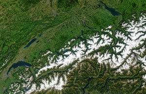
The Alps cover 65% of Switzerland's surface area (41,285 km²), making it one of the most alpine countries. Despite the fact that Switzerland covers only 14% of the Alps total area (192,753 km²), many alpine four-thousanders (48 of 82) are located in the Swiss Alps and the remaining few are within 20 km of the country's border.The glaciers of the Swiss Alps cover an area of 1230 km² (3% of the Swiss territory), representing 44% of the total glaciated area in the Alps (2800 km²).
The Swiss Alps are situated south of the Swiss plateau
Swiss plateau
The Swiss Plateau or Central Plateau constitutes one of the three major landscapes in Switzerland alongside the Jura mountains and the Swiss Alps. It covers about 30% of the Swiss surface...
and north of the national border. The limit between the Alps and the plateau runs from Vevey
Vevey
Vevey is a town in Switzerland in the canton Vaud, on the north shore of Lake Geneva, near Lausanne.It was the seat of the district of the same name until 2006, and is now part of the Riviera-Pays-d'Enhaut District...
on the shores of Lake Geneva
Lake Geneva
Lake Geneva or Lake Léman is a lake in Switzerland and France. It is one of the largest lakes in Western Europe. 59.53 % of it comes under the jurisdiction of Switzerland , and 40.47 % under France...
to Rorschach on the shores of Lake Constance
Lake Constance
Lake Constance is a lake on the Rhine at the northern foot of the Alps, and consists of three bodies of water: the Obersee , the Untersee , and a connecting stretch of the Rhine, called the Seerhein.The lake is situated in Germany, Switzerland and Austria near the Alps...
, passing close to the cities of Thun
Thun
Thun is a municipality in the administrative district of Thun in the canton of Bern in Switzerland with about 42,136 inhabitants , as of 1 January 2006....
and Lucerne
Lucerne
Lucerne is a city in north-central Switzerland, in the German-speaking portion of that country. Lucerne is the capital of the Canton of Lucerne and the capital of the district of the same name. With a population of about 76,200 people, Lucerne is the most populous city in Central Switzerland, and...
.
The countries with which Switzerland shares mountain ranges of the Alps are (from west to east): France
France
The French Republic , The French Republic , The French Republic , (commonly known as France , is a unitary semi-presidential republic in Western Europe with several overseas territories and islands located on other continents and in the Indian, Pacific, and Atlantic oceans. Metropolitan France...
, Italy
Italy
Italy , officially the Italian Republic languages]] under the European Charter for Regional or Minority Languages. In each of these, Italy's official name is as follows:;;;;;;;;), is a unitary parliamentary republic in South-Central Europe. To the north it borders France, Switzerland, Austria and...
, Austria
Austria
Austria , officially the Republic of Austria , is a landlocked country of roughly 8.4 million people in Central Europe. It is bordered by the Czech Republic and Germany to the north, Slovakia and Hungary to the east, Slovenia and Italy to the south, and Switzerland and Liechtenstein to the...
and Liechtenstein
Liechtenstein
The Principality of Liechtenstein is a doubly landlocked alpine country in Central Europe, bordered by Switzerland to the west and south and by Austria to the east. Its area is just over , and it has an estimated population of 35,000. Its capital is Vaduz. The biggest town is Schaan...
.
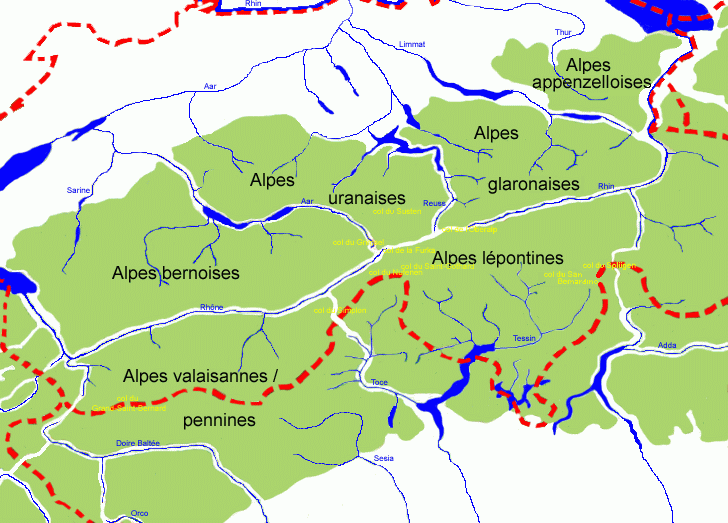
Ranges
The Alps are usually divided into two main parts, the Western Alps and Eastern AlpsEastern Alps
Eastern Alps is the name given to the eastern half of the Alps, usually defined as the area east of the Splügen Pass in eastern Switzerland. North of the Splügen Pass, the Posterior Rhine forms the border, and south of the pass, the Liro river and Lake Como form the boundary line.-Geography:The...
, whose division is along the Rhine from Lake Constance to the Splügen Pass
Splügen Pass
The Splügen Pass is a high mountain pass which marks the boundary between the Lepontine and Rhaetian Alps....
. The western ranges occupy the greatest part of Switzerland while the more numerous eastern ranges are much smaller and are all situated in the canton of Graubünden
Graubünden
Graubünden or Grisons is the largest and easternmost canton of Switzerland. The canton shares borders with the cantons of Ticino, Uri, Glarus and St. Gallen and international borders with Italy, Austria and Liechtenstein...
. The latter are part of the Central Eastern Alps
Central Eastern Alps
The Central Eastern Alps comprise the main chain of the Eastern Alps with its highest peaks, located between the Northern Limestone Alps and the Southern Limestone Alps, from which they differ in geological composition....
, except the Ortler Alps
Ortler Alps
The Ortler Alps are a mountain range in the central Alps of Italy. They are considered to be part of the Central Eastern Alps or the Southern Limestone Alps....
which belong to the Southern Limestone Alps
Southern Limestone Alps
The Southern Limestone Alps are the ranges of the Eastern Alps south of the Central Eastern Alps mainly located in northern Italy and the adjacent lands of Austria and Slovenia. The distinction from the Central Alps, where the higher peaks are located, is based on differences in geological...
. The Pennine
Pennine Alps
The Pennine Alps are a mountain range in the western part of the Alps. They are located in Switzerland and Italy...
, Bernese
Bernese Alps
The Bernese Alps are a group of mountain ranges in the western part of the Alps, in Switzerland. Although the name suggests that they are located in the Bernese Oberland region of the canton of Bern, portions of the Bernese Alps are in the adjacent cantons of Valais, Lucerne, Obwalden, Fribourg and...
and Bernina Range
Bernina Range
The Bernina Range is a mountain range in the Alps of eastern Switzerland and northern Italy. It is considered to be part of the Central Eastern Alps. It is one of the highest ranges of the Alps, covered with many glaciers. Piz Bernina , its highest peak, is the most easterly four thousand-metre...
are the highest ranges of the country, they contain respectively 38, 9 and 1 summit over 4000 metres. The lowest range is the Appenzell Alps
Appenzell Alps
The Appenzell Alps are a mountain range in Switzerland on the northern edge of the Alps. They extend into the cantons of Appenzell Ausserrhoden, Appenzell Innerrhoden and St...
culminating at 2,500 metres.
(*) situated out of the main chain
Main chain of the Alps
The Alpine divide is the central line of mountains that forms the water divide of the range. Main chains of mountain ranges are traditionally designated in this way, and generally include the highest peaks of a range; the Alps are something of an unusual case in that several significant groups of...
Western Alps
| Location | Range | Cantons | Notable peaks | East limit |
|---|---|---|---|---|
| From west to east, north of Rhone Rhône Rhone can refer to:* Rhone, one of the major rivers of Europe, running through Switzerland and France* Rhône Glacier, the source of the Rhone River and one of the primary contributors to Lake Geneva in the far eastern end of the canton of Valais in Switzerland... and Rhine |
||||
| Bernese Alps Bernese Alps The Bernese Alps are a group of mountain ranges in the western part of the Alps, in Switzerland. Although the name suggests that they are located in the Bernese Oberland region of the canton of Bern, portions of the Bernese Alps are in the adjacent cantons of Valais, Lucerne, Obwalden, Fribourg and... * |
Vaud Vaud Vaud is one of the 26 cantons of Switzerland and is located in Romandy, the French-speaking southwestern part of the country. The capital is Lausanne. The name of the Canton in Switzerland's other languages are Vaud in Italian , Waadt in German , and Vad in Romansh.-History:Along the lakes,... , Fribourg Canton of Fribourg The Canton of Fribourg is a canton of Switzerland. It is located in the west of the country. The capital of the canton is Fribourg. The name Fribourg is French, whereas is the German name for both the canton and the town.-History:... , Valais Valais The Valais is one of the 26 cantons of Switzerland in the southwestern part of the country, around the valley of the Rhône from its headwaters to Lake Geneva, separating the Pennine Alps from the Bernese Alps. The canton is one of the drier parts of Switzerland in its central Rhône valley... , Berne Canton of Berne The Canton of Bern is the second largest of the 26 Swiss cantons by both surface area and population. Located in west-central Switzerland, it borders the Canton of Jura and the Canton of Solothurn to the north. To the west lie the Canton of Neuchâtel, the Canton of Fribourg and Vaud. To the south... |
Finsteraarhorn Finsteraarhorn The Finsteraarhorn is the highest mountain in the Bernese Alps and the highest mountain in the canton of Berne. It is also the highest summit in the Alps lying outside the main chain, or watershed. The Finsteraarhorn is the ninth highest and third most prominent peak in the Alps... , Jungfrau Jungfrau The Jungfrau is one of the main summits in the Bernese Alps, situated between the cantons of Valais and Bern in Switzerland... , Eiger Eiger The Eiger is a mountain in the Bernese Alps in Switzerland. It is the easternmost peak of a ridge crest that extends across the Mönch to the Jungfrau at 4,158 m... |
Grimsel Pass Grimsel Pass Grimsel Pass is a Swiss high mountain pass.-Position:It connects the valley of the Rhone River in the canton of Valais and the Haslital in the canton of Bern.... |
|
| Urner Alps Urner Alps The Urner Alps are a mountain range in central Switzerland in the western part of the Alps. They extend into the cantons of Obwalden, Valais, Lucerne, Bern, Uri and Nidwalden and are bordered by the Bernese Alps to the west, the Lepontine Alps to the south and the Glarus Alps to the east.The Urner... * |
Uri Canton of Uri Uri is one of the 26 cantons of Switzerland and a founding member of the Swiss Confederation. It is located in Central Switzerland. The canton's territory covers the valley of the Reuss River between Lake Lucerne and the St. Gotthard Pass. German is the primary language spoken in Uri... , Bern, Valais Valais The Valais is one of the 26 cantons of Switzerland in the southwestern part of the country, around the valley of the Rhône from its headwaters to Lake Geneva, separating the Pennine Alps from the Bernese Alps. The canton is one of the drier parts of Switzerland in its central Rhône valley... , Lucerne Canton of Lucerne Lucerne is a canton of Switzerland. It is located in the centre of Switzerland. The population of the canton is . , the population included 57,268 foreigners, or about 15.8% of the total population. The cantonal capital is Lucerne.-History:... , Obwalden Obwalden Obwalden is a canton of Switzerland. It is located in the centre of Switzerland. The population is 33,997 of which 4,043 are foreigners. Its capital is Sarnen. The canton contains the geographical centre of Switzerland.-History:... , Nidwalden Nidwalden Nidwalden is a canton of Switzerland. It is located in the centre of Switzerland. The population is 40,287 of which 4,046 are foreigners. The capital is Stans.-History:... |
Dammastock Dammastock The Dammastock is the highest mountain in the Urner Alps in Switzerland. Its summit ridge forms the border between the cantons of Uri and the Valais. It is the highest summit in the canton of Uri... , Titlis Titlis The Titlis is a mountain in the Urner Alps of Switzerland. It is located on the border between the cantons of Obwalden and Berne in Switzerland, overlooking Engelberg and is famous as the site of the world's first revolving cable car... |
Reuss river Reuss River The Reuss is a river in Switzerland. With a length of and a drainage basin of , it is the fourth largest river in Switzerland... |
|
| Glarus Alps Glarus Alps The Glarus Alps are a mountain range in central Switzerland. They extend from the Oberalp Pass to the Klausen Pass, and are bordered by the Urner Alps to the west, the Lepontine Alps to the south and the Appenzell Alps to the northeast... * |
Uri Canton of Uri Uri is one of the 26 cantons of Switzerland and a founding member of the Swiss Confederation. It is located in Central Switzerland. The canton's territory covers the valley of the Reuss River between Lake Lucerne and the St. Gotthard Pass. German is the primary language spoken in Uri... , Glarus Canton of Glarus The Canton of Glarus is a canton in east central Switzerland. The capital is Glarus.The population speaks a variety of Alemannic German.The majority of the population identifies as Christian, about evenly split between the Protestant and Catholic confessions.-History:According to legend, the... , Graubünden Graubünden Graubünden or Grisons is the largest and easternmost canton of Switzerland. The canton shares borders with the cantons of Ticino, Uri, Glarus and St. Gallen and international borders with Italy, Austria and Liechtenstein... |
Tödi Tödi The Tödi , or Piz Russein, is the highest mountain in the Glarus Alps and the highest summit in the Canton of Glarus, Switzerland. It is located on the border between the cantons of Graubünden and Glarus... , Glärnisch Glärnisch The Glärnisch is a mountain of the Glarus Alps, overlooking the valley of the Linth in the canton of Glarus. It consists of several summits of which the highest is distinguished by the name Bächistock, followed by the Vrenelisgärtli and the Ruchen .The massif of the Glärnisch consists of two... |
Seeztal Seeztal The Seeztal is a valley of the canton of St. Gallen, Switzerland, extending to the east of Lake Walen for some 10 km, formed by the river Seez. The valley appears to be a left branch off the Rhine valley at Sargans, but there is a divide at Mels... |
|
| Appenzell Alps Appenzell Alps The Appenzell Alps are a mountain range in Switzerland on the northern edge of the Alps. They extend into the cantons of Appenzell Ausserrhoden, Appenzell Innerrhoden and St... * |
Appenzell Innerrhoden Appenzell Innerrhoden Appenzell Innerrhoden is the smallest canton of Switzerland by population and the second smallest by area, Basel-City having less area.-Foundation:... , Appenzell Ausserrhoden Appenzell Ausserrhoden Appenzell Ausserrhoden is a canton of Switzerland. The seat of the government and parliament is Herisau, judicial authorities are in Trogen. Appenzell Ausserrhoden is located in the north east of Switzerland, bordering the cantons of St... , St. Gallen Canton of St. Gallen The Canton of St. Gallen is a canton of Switzerland. St. Gallen is located in the north east of Switzerland. It covers an area of 2,026 km², and has a population of . , the population included 97,461 foreigners, or about 20.9% of the total population. The capital is St. Gallen. Spelling... |
Säntis Säntis At 2,502.9 meters above sea level, Säntis is the tallest mountain in the Alpstein massif of northeastern Switzerland. The mountain is a highly visible landmark thanks to its exposed northerly location within the Alpstein massif. As a consequence, houses called Säntisblick can be found in regions... |
Rhine | |
| From west to east, south of Rhone Rhône Rhone can refer to:* Rhone, one of the major rivers of Europe, running through Switzerland and France* Rhône Glacier, the source of the Rhone River and one of the primary contributors to Lake Geneva in the far eastern end of the canton of Valais in Switzerland... and Rhine |
||||
| Chablais Alps Chablais Alps The Chablais Alps are a mountain range in the western Alps. They are situated between Lake Geneva and the Mont Blanc Massif. The Col des Montets separates them from the Mont Blanc Massif in the south, and the Rhône valley separates them from the Bernese Alps in the east.The Chablais Alps are... |
Valais Valais The Valais is one of the 26 cantons of Switzerland in the southwestern part of the country, around the valley of the Rhône from its headwaters to Lake Geneva, separating the Pennine Alps from the Bernese Alps. The canton is one of the drier parts of Switzerland in its central Rhône valley... |
Dents du Midi Dents du Midi The Dents du Midi is a mountain chain situated in the Chablais Alps in the Canton of Valais, Switzerland. It is composed of seven distinct summits and reaches a height of 3257 metres... |
Arve Arve The Arve river flows for approximately 100 km through France, in the département of Haute-Savoie, and in Switzerland... |
|
| Mont Blanc Massif Mont Blanc Massif The Mont Blanc massif is a mountain range in the western Alps. It is named after Mont Blanc, at 4,810.45 m the highest summit of the Alps. It is located in France , Italy , and Switzerland... |
Valais Valais The Valais is one of the 26 cantons of Switzerland in the southwestern part of the country, around the valley of the Rhône from its headwaters to Lake Geneva, separating the Pennine Alps from the Bernese Alps. The canton is one of the drier parts of Switzerland in its central Rhône valley... |
Aiguille d'Argentière Aiguille d'Argentière The Aiguille d'Argentière is a mountain in the Mont Blanc massif on the border between France and Switzerland.The first ascent of the mountain was by a British party comprising Edward Whymper and A. Reilly with guides Michel Croz, M. Payot, H. Charlet on 15 July 1864... |
Col Ferret Col Ferret The Col Ferret is an Alpine pass between the canton of Valais and the Aosta Valley. This pass separates the Mont Blanc Massif from the Pennine Alps.-See also:* List of highest paved roads in Europe... |
|
| Pennine Alps Pennine Alps The Pennine Alps are a mountain range in the western part of the Alps. They are located in Switzerland and Italy... |
Valais Valais The Valais is one of the 26 cantons of Switzerland in the southwestern part of the country, around the valley of the Rhône from its headwaters to Lake Geneva, separating the Pennine Alps from the Bernese Alps. The canton is one of the drier parts of Switzerland in its central Rhône valley... |
Monte Rosa Monte Rosa The Monte Rosa Massif is a mountain massif located in the eastern part of the Pennine Alps. It is located between Switzerland and Italy... , Weisshorn Weisshorn The Weisshorn is a mountain in the Pennine Alps, in Switzerland. With its summit, it is one of the major peaks in the Alps and overtops the nearby Matterhorn by some 30 metres. It was first climbed in 1861 from Randa by John Tyndall, accompanied by the guides J.J... , Matterhorn Matterhorn The Matterhorn , Monte Cervino or Mont Cervin , is a mountain in the Pennine Alps on the border between Switzerland and Italy. Its summit is 4,478 metres high, making it one of the highest peaks in the Alps. The four steep faces, rising above the surrounding glaciers, face the four compass points... |
Simplon Pass Simplon Pass Simplon Pass is a high mountain pass between the Pennine Alps and the Lepontine Alps in Switzerland. It connects Brig in the canton of Valais with Domodossola in Piedmont . The pass itself and the villages on each side of it, such as Gondo, are in Switzerland... |
|
| Lepontine Alps Lepontine Alps The Lepontine Alps are a mountain range in the central part of the Alps. They are located in Switzerland and Italy .On the north the upper Rhône valley separate them from the Bernese Alps and the Furka Pass and the upper Reuss valley separates them from the Urner Alps; on the west the Simplon Pass... |
Valais Valais The Valais is one of the 26 cantons of Switzerland in the southwestern part of the country, around the valley of the Rhône from its headwaters to Lake Geneva, separating the Pennine Alps from the Bernese Alps. The canton is one of the drier parts of Switzerland in its central Rhône valley... , Ticino Ticino Canton Ticino or Ticino is the southernmost canton of Switzerland. Named after the Ticino river, it is the only canton in which Italian is the sole official language... , Uri Canton of Uri Uri is one of the 26 cantons of Switzerland and a founding member of the Swiss Confederation. It is located in Central Switzerland. The canton's territory covers the valley of the Reuss River between Lake Lucerne and the St. Gotthard Pass. German is the primary language spoken in Uri... Graubünden Graubünden Graubünden or Grisons is the largest and easternmost canton of Switzerland. The canton shares borders with the cantons of Ticino, Uri, Glarus and St. Gallen and international borders with Italy, Austria and Liechtenstein... , |
Monte Leone Monte Leone Monte Leone is the highest mountain of the Lepontine Alps and is located on the border between Switzerland and Italy. The mountain is located on the extreme west of the Lepontine Alps, a few kilometres east of Simplon Pass.-External links:*... , Rheinwaldhorn Rheinwaldhorn The Rheinwaldhorn is the highest point in the Swiss canton of Ticino at 3402m. It lies on the border between the cantons of Graubünden and Ticino, in the Adula massif, part of the St. Gotthard massif of the Lepontine Alps in southern Switzerland.... |
Splügen Pass Splügen Pass The Splügen Pass is a high mountain pass which marks the boundary between the Lepontine and Rhaetian Alps.... |
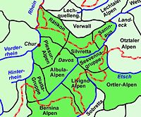
Eastern Alps
| Location | Range | Notable peaks |
|---|---|---|
| From west to east, north of Mera Mera River The Mera is a river in Switzerland and Italy. Its source is near the Maloja Pass, in Graubünden, Switzerland. It flows west through the Val Bregaglia and crosses the Italian border near Soglio... and Inn river Inn River The Inn is a river in Switzerland, Austria and Germany. It is a right tributary of the Danube and is approximately 500km long. The highest point of its drainage basin is the summit of Piz Bernina, at 4,049 metres.- Geography :... |
||
| Oberhalbstein Oberhalbstein Range The Oberhalbstein Range is a mountain range in the Alps of eastern Switzerland and northern Italy. It is considered to be part of the Central Eastern Alps... |
Piz Platta Piz Platta Piz Platta is the highest peak in the Oberhalbstein Range, located in Graubünden, Switzerland. It is 3392 metres high , and is notable for its similarity in shape to the Matterhorn.-External links:*... |
|
| Plessur Plessur Range The Plessur Range is a mountain range in the Alps of eastern Switzerland. It is considered to be part of the Central Eastern Alps. It is named after the river Plessur, which originates from the center of the ranges... * |
Aroser Weisshorn Aroser Weisshorn Aroser Weisshorn is a mountain in the Plessur Range in Switzerland.A two-stage cable car links the top of the mountain with the town and resort of Arosa — the base station is near to Arosa railway station.-External links:*... |
|
| Albula Albula Range The Albula Alps is a mountain range in the Alps of eastern Switzerland. It is considered to be part of the Central Eastern Alps. It is named after the River Albula... |
Piz Kesch Piz Kesch Piz Kesch or Piz d'Es-cha is a peak in the Albula Range of the Rhaetian Alps. At 3,418 m, it is the highest peak in the Albula Range and the municipality of Bergün, Grisons.... , Piz Lunghin Piz Lunghin Piz Lunghin is a mountain in the Swiss canton of Graubünden, located in the Albula range, overlooking the Maloja Pass. It can be considered as the "roof of Europe" as the water running off the mountain can head towards the Atlantic, Mediterranean or Black Sea.-Geography and hydrography:Piz Lunghin... |
|
| Rätikon Rätikon The Rätikon is a mountain range of the Central Eastern Alps located at the border between Vorarlberg, Liechtenstein and Graubünden. It is the geological border between the Eastern and Western Alps and stretches from the Montafon as far as the Rhine. In the south, the Prättigau is its limit, in the... * |
Schesaplana Schesaplana The Schesaplana is the highest mountain in the Rätikon mountain range at the border between Vorarlberg, Austria and Graubuenden, Switzerland. It has an elevation of .... |
|
| Silvretta* | Piz Linard Piz Linard Piz Linard is a pyramid-shaped mountain of the Swiss Alps. At 3,410 m it is the highest peak of the Silvretta mountain range.It was first climbed on August 1, 1835 by the geologist and naturalist Oswald Heer led by Johann Madutz.... , Piz Buin Piz Buin Piz Buin is a mountain in the Silvretta range of the Alps on the border between Austria and Switzerland. It forms the border between the Swiss canton of Graubünden and the Austrian state of Vorarlberg and is the highest peak in Vorarlberg.... |
|
| Samnaun Alps Samnaun Alps The Samnaun Alps are a mountain range of the Central Eastern Alps, named after the Swiss municipality of Samnaun. They are located at the border of the Austrian state of Tyrol and the Graubünden canton of Switzerland.The range includes the following peaks:... * |
Muttler Muttler The Muttler is the highest mountain in the Samnaun Alps. It is located south of Samnaun in Graubünden, Switzerland.-External links:*... |
|
| From west to east, south of Mera Mera River The Mera is a river in Switzerland and Italy. Its source is near the Maloja Pass, in Graubünden, Switzerland. It flows west through the Val Bregaglia and crosses the Italian border near Soglio... and Inn river Inn River The Inn is a river in Switzerland, Austria and Germany. It is a right tributary of the Danube and is approximately 500km long. The highest point of its drainage basin is the summit of Piz Bernina, at 4,049 metres.- Geography :... |
||
| Bregaglia Bregaglia Range The Bregaglia Range is a small group of mostly granite mountains in Graubünden, Switzerland and the Province of Sondrio, northern Italy. It derives its name from the partly Swiss, partly Italian valley, the Val Bregaglia, and is known as Bergell in German... |
Cima di Castello Cima di Castello Cima di Castello is the second highest mountain in the Bregaglia Range, located on the border between Italy and the Swiss canton of Graubünden.-External links:*... , Piz Badile Piz Badile Piz Badile is a mountain in the Bregaglia range in the Swiss canton of Graubünden and Italy, the border between the two countries running along the summit ridge. Its northeast face is considered one of the six great north faces of the Alps.... |
|
| Bernina Bernina Range The Bernina Range is a mountain range in the Alps of eastern Switzerland and northern Italy. It is considered to be part of the Central Eastern Alps. It is one of the highest ranges of the Alps, covered with many glaciers. Piz Bernina , its highest peak, is the most easterly four thousand-metre... |
Piz Bernina Piz Bernina Piz Bernina is the highest mountain of the Eastern Alps and the highest point of the Bernina Range the highest peak in south Rhetic Alps. It is also the farthest easterly mountain higher than 4,000 m in the Alps, the highest point of the Swiss canton of Graubünden, and the fifth-most prominent... , Piz Roseg Piz Roseg Piz Roseg is a mountain in the Bernina Range in Graubünden, Switzerland.There are two summits on its main ridge:*the south-east and higher summit *the north-west summit, known as the Schneekuppe .... |
|
| Albula Albula Range The Albula Alps is a mountain range in the Alps of eastern Switzerland. It is considered to be part of the Central Eastern Alps. It is named after the River Albula... |
Piz Kesch Piz Kesch Piz Kesch or Piz d'Es-cha is a peak in the Albula Range of the Rhaetian Alps. At 3,418 m, it is the highest peak in the Albula Range and the municipality of Bergün, Grisons.... , Piz Lunghin Piz Lunghin Piz Lunghin is a mountain in the Swiss canton of Graubünden, located in the Albula range, overlooking the Maloja Pass. It can be considered as the "roof of Europe" as the water running off the mountain can head towards the Atlantic, Mediterranean or Black Sea.-Geography and hydrography:Piz Lunghin... |
|
| Livigno Livigno Range The Livigno Range is a mountain range in the Alps of eastern Switzerland and northern Italy, around the Italian village Livigno. It is considered to be part of the Central Eastern Alps.... |
Piz Paradisin Piz Paradisin The Piz Paradisin is a mountain in the Livigno Range , located on the border between Italy and Switzerland.-External links:*... |
|
| Ortler Alps Ortler Alps The Ortler Alps are a mountain range in the central Alps of Italy. They are considered to be part of the Central Eastern Alps or the Southern Limestone Alps.... * |
Piz Murtaröl Piz Murtaröl Piz Murtaröl is a mountain in the Livigno Range of the Ortler Alps, located on the border between Italy and Switzerland.-External links:*... |
|
| Sesvenna Sesvenna Range The Sesvenna Range is a mountain range in the Alps of eastern Switzerland, northern Italy and western Austria. It is considered to be part of the Central Eastern Alps.... |
Piz Sesvenna Piz Sesvenna The Piz Sesvenna is the highest mountain of the Sesvenna Range , located in Graubünden, Switzerland. The summit is located close to the Italian border and main watershed.The mountain lies south of Scuol in the Engadin valley.-External links:*... |
Rivers
Rhône
Rhone can refer to:* Rhone, one of the major rivers of Europe, running through Switzerland and France* Rhône Glacier, the source of the Rhone River and one of the primary contributors to Lake Geneva in the far eastern end of the canton of Valais in Switzerland...
, Rhine and Inn river
Inn River
The Inn is a river in Switzerland, Austria and Germany. It is a right tributary of the Danube and is approximately 500km long. The highest point of its drainage basin is the summit of Piz Bernina, at 4,049 metres.- Geography :...
(which is part of the Danube basin) while the south side is mainly drained by the Ticino river
Ticino River
The river Ticino is a left-bank tributary of the Po River. It has given its name to the Swiss canton through which its upper portion flows.-The course:...
(Po basin). The rivers on the north empty into the Mediterranean
Mediterranean Sea
The Mediterranean Sea is a sea connected to the Atlantic Ocean surrounded by the Mediterranean region and almost completely enclosed by land: on the north by Anatolia and Europe, on the south by North Africa, and on the east by the Levant...
, North
North Sea
In the southwest, beyond the Straits of Dover, the North Sea becomes the English Channel connecting to the Atlantic Ocean. In the east, it connects to the Baltic Sea via the Skagerrak and Kattegat, narrow straits that separate Denmark from Norway and Sweden respectively...
and Black Sea
Black Sea
The Black Sea is bounded by Europe, Anatolia and the Caucasus and is ultimately connected to the Atlantic Ocean via the Mediterranean and the Aegean seas and various straits. The Bosphorus strait connects it to the Sea of Marmara, and the strait of the Dardanelles connects that sea to the Aegean...
, on the south the Po empty in the Adriatic Sea
Adriatic Sea
The Adriatic Sea is a body of water separating the Italian Peninsula from the Balkan peninsula, and the system of the Apennine Mountains from that of the Dinaric Alps and adjacent ranges...
. The major triple watersheds in the Alps are located within the country, they are: Piz Lunghin
Piz Lunghin
Piz Lunghin is a mountain in the Swiss canton of Graubünden, located in the Albula range, overlooking the Maloja Pass. It can be considered as the "roof of Europe" as the water running off the mountain can head towards the Atlantic, Mediterranean or Black Sea.-Geography and hydrography:Piz Lunghin...
, Witenwasserenstock
Witenwasserenstock
The Witenwasserenstock is a peak between the Swiss cantons of Valais and Uri, located in the Lepontine Alps. Close to the summit lies the tripoint border between the cantons of Valais, Uri and Ticino and the triple watershed of the Rhine, Po and Rhône basins.-Geography and hydrography:The...
and Monte Forcola
Monte Forcola
Monte Forcola is a peak in Graubünden, Switzerland, close to the Italian border. Near the summit is located the triple watershed of the Adige, Po and Danube basins....
. Between the Witenwasserenstock and Piz Lunghin runs the European Watershed
European Watershed
The European Watershed is the line which divides the drainage basins of the major rivers of Germany: the Rhine, which originates in the Swiss Alps and empties into the North Sea via the Netherlands, and the Danube, which originates in the Black Forest and flows eastward emptying into the Black...
separating the basin of the Atlantic (North Sea) and the Mediterranean Sea (Adriatic and Black Sea). The European watershed lies in fact only partially on the main chain
Main chain of the Alps
The Alpine divide is the central line of mountains that forms the water divide of the range. Main chains of mountain ranges are traditionally designated in this way, and generally include the highest peaks of a range; the Alps are something of an unusual case in that several significant groups of...
. Switzerland possesses 6% of Europe's fresh water, and is sometimes referred to as the "water tower of Europe".
Lakes
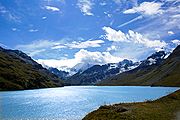
Engadin
The Engadin or Engadine is a long valley in the Swiss Alps located in the canton of Graubünden in southeast Switzerland. It follows the route of the Inn River from its headwaters at Maloja Pass running northeast until the Inn flows into Austria one hundred kilometers downstream...
such as Lake Sils
Lake Sils
Lake Sils is a lake in the Upper Engadine valley, Grisons, Switzerland. It takes its name from the village of Sils im Engadin.The wooded Chasté peninsula extends into the lake at its north-eastern end...
, and Oeschinen
Oeschinen Lake
Oeschinen Lake is a lake in the Bernese Oberland, Switzerland, east of Kandersteg in the Oeschinen valley. At an elevation of , it has a surface area of . Its maximum depth is ....
in the Bernese Oberland). The melting of low-altitude glaciers can generate new lakes, such as the 0.25 km² large Triftsee
Triftsee
The Triftsee is a lake in the Urner Alps near Gadmen in the canton of Berne, Switzerland. It was formed recently by the melting of the lower part of Trift Glacier.- References :*...
which formed between 2002–2003.
Land elevation
The following table gives the surface area above 2000 m and 3000 m and the respective percentage on the total area of each canton whose high point is above 2000 metres.| Canton | Land above 2000m in km² | Land above 2000m in % | Land above 3000m in km² | Land above 3000m in % |
|---|---|---|---|---|
| Appenzell Ausserrhoden Appenzell Ausserrhoden Appenzell Ausserrhoden is a canton of Switzerland. The seat of the government and parliament is Herisau, judicial authorities are in Trogen. Appenzell Ausserrhoden is located in the north east of Switzerland, bordering the cantons of St... |
1 | 0.4 | 0 | 0 |
| Appenzell Innerrhoden Appenzell Innerrhoden Appenzell Innerrhoden is the smallest canton of Switzerland by population and the second smallest by area, Basel-City having less area.-Foundation:... |
4 | 2.3 | 0 | 0 |
| Berne Canton of Berne The Canton of Bern is the second largest of the 26 Swiss cantons by both surface area and population. Located in west-central Switzerland, it borders the Canton of Jura and the Canton of Solothurn to the north. To the west lie the Canton of Neuchâtel, the Canton of Fribourg and Vaud. To the south... |
887 | 15 | 100 | 1.7 |
| Fribourg Canton of Fribourg The Canton of Fribourg is a canton of Switzerland. It is located in the west of the country. The capital of the canton is Fribourg. The name Fribourg is French, whereas is the German name for both the canton and the town.-History:... |
14 | 0.8 | 0 | 0 |
| Glarus Canton of Glarus The Canton of Glarus is a canton in east central Switzerland. The capital is Glarus.The population speaks a variety of Alemannic German.The majority of the population identifies as Christian, about evenly split between the Protestant and Catholic confessions.-History:According to legend, the... |
213 | 31 | 4 | 0.6 |
| Graubünden Graubünden Graubünden or Grisons is the largest and easternmost canton of Switzerland. The canton shares borders with the cantons of Ticino, Uri, Glarus and St. Gallen and international borders with Italy, Austria and Liechtenstein... |
4296 | 60 | 111 | 1.6 |
| Lucerne Canton of Lucerne Lucerne is a canton of Switzerland. It is located in the centre of Switzerland. The population of the canton is . , the population included 57,268 foreigners, or about 15.8% of the total population. The cantonal capital is Lucerne.-History:... |
4 | 0.3 | 0 | 0 |
| Nidwalden Nidwalden Nidwalden is a canton of Switzerland. It is located in the centre of Switzerland. The population is 40,287 of which 4,046 are foreigners. The capital is Stans.-History:... |
20 | 7 | 0 | 0 |
| Obwalden Obwalden Obwalden is a canton of Switzerland. It is located in the centre of Switzerland. The population is 33,997 of which 4,043 are foreigners. Its capital is Sarnen. The canton contains the geographical centre of Switzerland.-History:... |
66 | 13 | 1 | 0.2 |
| Schwyz Canton of Schwyz Schwyz is a canton in central Switzerland between the Alps in the south, Lake Lucerne in the east and Lake Zurich in the north, centered around and named after the town of Schwyz.... |
69 | 8 | 0 | 0 |
| St. Gallen | 184 | 9 | 1 | 0.05 |
| Ticino Ticino Canton Ticino or Ticino is the southernmost canton of Switzerland. Named after the Ticino river, it is the only canton in which Italian is the sole official language... |
781 | 28 | 2 | 0.07 |
| Uri Canton of Uri Uri is one of the 26 cantons of Switzerland and a founding member of the Swiss Confederation. It is located in Central Switzerland. The canton's territory covers the valley of the Reuss River between Lake Lucerne and the St. Gotthard Pass. German is the primary language spoken in Uri... |
562 | 52 | 19 | 1.8 |
| Valais Valais The Valais is one of the 26 cantons of Switzerland in the southwestern part of the country, around the valley of the Rhône from its headwaters to Lake Geneva, separating the Pennine Alps from the Bernese Alps. The canton is one of the drier parts of Switzerland in its central Rhône valley... |
2595 | 50 | 697 | 13 |
| Vaud Vaud Vaud is one of the 26 cantons of Switzerland and is located in Romandy, the French-speaking southwestern part of the country. The capital is Lausanne. The name of the Canton in Switzerland's other languages are Vaud in Italian , Waadt in German , and Vad in Romansh.-History:Along the lakes,... |
92 | 3 | 1 | 0.03 |
| Switzerland Switzerland Switzerland name of one of the Swiss cantons. ; ; ; or ), in its full name the Swiss Confederation , is a federal republic consisting of 26 cantons, with Bern as the seat of the federal authorities. The country is situated in Western Europe,Or Central Europe depending on the definition.... |
9788 | 24 | 936 | 2.3 |
Geology
Austroalpine nappes
The Austroalpine nappes are a geological nappe stack in the European Alps. The Alps contain three such stacks, of which the Austroalpine nappes are structurally on top of the other two...
- Southern Alps
Southern Alps (geology)
The Southern Alps are a geological subdivision of the European Alps. The Southern Alps are the part of the Alps that are found south of the Periadriatic Seam, a major geological faultzone across the Alps...
on the south come originally from the European and African continent respectively. The rocks of the Penninic nappes
Penninic nappes
The Penninic nappes or the Penninicum are one of three nappe stacks and geological zones in which the Alps can be divided. In the western Alps the Penninic nappes are more obviously present than in the eastern Alps , where they crop out as a narrow band...
belong to the former area of the Briançonnais microcontinent
Briançonnais microcontinent
The Briançonnais zone or Briançonnais terrane is a piece of continental crust found in the Penninic nappes of the Alps.According to some paleogeographic reconstructions the rocks of the Briançonnais zone were in fact a part of the microcontinent Iberia, that encompassed not only the Iberian...
and the Tethys Ocean
Tethys Ocean
The Tethys Ocean was an ocean that existed between the continents of Gondwana and Laurasia during the Mesozoic era before the opening of the Indian Ocean.-Modern theory:...
. The closure of the latter by subduction under the African plate (Piemont Ocean
Piemont-Liguria Ocean
The Piemont-Liguria basin or the Piemont-Liguria Ocean was a former piece of oceanic crust that is seen as part of the Tethys Ocean...
first and Valais Ocean
Valais Ocean
The Valais Ocean is a disappeared piece of oceanic crust which was situated between the continent Europe and the microcontinent Iberia or so called Briançonnais microcontinent...
later) preceded the collision between the two plates and the so-called alpine orogeny. The major thrust fault of the Tectonic Arena Sardona
Glarus thrust
The Glarus thrust is a major thrust fault in the Alps of eastern Switzerland. Along the thrust the Helvetic nappes were thrusted more than 100 km to the north over the external Aarmassif and Infrahelvetic complex...
in the eastern Glarus Alps gives a visible illustration of mountain-building processes and was therefore declared a UNESCO World Heritage. Another fine example gives the Alpstein
Alpstein
The Alpstein are a subgroup of the Appenzell Alps in Switzerland. The Alpstein massif is in Appenzell Innerrhoden, Appenzell Ausserrhoden and St...
area with several visible upfolds of Helvetic zone material.
With some exceptions, the Alps north of Rhone
Rhône River
The Rhone is one of the major rivers of Europe, rising in Switzerland and running from there through southeastern France. At Arles, near its mouth on the Mediterranean Sea, the river divides into two branches, known as the Great Rhone and the Little Rhone...
and Rhine river are part of the Helvetic Zone and those on the south side are part of the Penninic nappes. The Austroalpine zone concerns almost only the Eastern Alps, with the notable exception of the Matterhorn
Matterhorn
The Matterhorn , Monte Cervino or Mont Cervin , is a mountain in the Pennine Alps on the border between Switzerland and Italy. Its summit is 4,478 metres high, making it one of the highest peaks in the Alps. The four steep faces, rising above the surrounding glaciers, face the four compass points...
.
The last glaciations greatly transformed Switzerland’s landscape. Many valleys of the Swiss Alps are U-shaped due to glacial erosion. During the maximum extension of the Würm glaciation (18,000 years ago) the glaciers completely covered the Swiss Plateau
Swiss plateau
The Swiss Plateau or Central Plateau constitutes one of the three major landscapes in Switzerland alongside the Jura mountains and the Swiss Alps. It covers about 30% of the Swiss surface...
, before retreating and leaving remnants only in high mountain areas. In modern times the Aletsch Glacier
Aletsch Glacier
The Aletsch Glacier or Great Aletsch Glacier is the largest glacier in the Alps. It has a length of about and covers more than in the eastern Bernese Alps in the Swiss canton of Valais...
in the western Bernese Alps is the largest and longest in the Alps, reaching a maximum depth of 900 metres (2953 ft) at Konkordia. Along with the Fiescher
Fiescher Glacier
The Fiescher Glacier is a valley glacier on the south side of the Bernese Alps in the canton of Valais, Switzerland. in length, it is the second longest glacier in the Alps...
and Aar Glaciers
Aar Glaciers
The Aar Glaciers are glaciers located at the sources of the Aar River in the Bernese Alps, Switzerland. They are constituted by two distinct glacier systems:...
the region became a UNESCO World Heritage Site in 2001. An effect of the retreat of the Rhine Glacier some 10'000 years ago was the Flims Rockslide
Flims Rockslide
Flims Rockslide occurred some 10000 years ago. It is known as the biggest Landslide incident in the Alps and the biggest worldwide whose effects are still visible, moving some of rock, about 300 times that of the historic Swiss Goldau landslide. The town of Flims can be found at the line where...
, the biggest still visible landslide
Landslide
A landslide or landslip is a geological phenomenon which includes a wide range of ground movement, such as rockfalls, deep failure of slopes and shallow debris flows, which can occur in offshore, coastal and onshore environments...
apparently worldwide.
Environment and climate
To protect endengered species some sites have been brought under protection. The Swiss National ParkSwiss National Park
The Swiss National Park is located in the canton of Graubünden in the east of Switzerland between Zernez, S-chanf, Scuol and the Fuorn Pass in the Engadin valley on the border with Italy....
in Graubünden was established in 1914 as the first alpine national park. The Entlebuch
Entlebuch Biosphere
The Entlebuch Biosphere is a natural reserve at the foot of the Alps which includes the 395 km² large valley of the Little Emme River between Bern and Lucerne in the Swiss Canton of Lucerne....
area was designated a biosphere reserve in 2001. The largest protected area in the country is the Parc Ela
Parc Ela
Parc Ela is a Nature Park in the canton of Graubünden, Switzerland. It is intended to protect the regional biotope, help promote its sustainable use and give a boost to an area rich in scenery and national cultural assets, but weak economically.Unlike Switzerland's only National Park, which is...
, opened in 2006, which covers an area of 600 square kilometres. The Jungfrau-Aletsch Protected Area
Jungfrau-Aletsch Protected Area
The Jungfrau-Aletsch protected area is located in south-western Switzerland between the cantons of Berne and Valais. It is a mountainous region in the easternmost side of the Bernese Alps, containing the northern wall of Jungfrau and Eiger, and the largest glaciated area in western Eurasia,...
is the first World Heritage Site in the Alps.
Climate zones
As the temperature decreasesLapse rate
The lapse rate is defined as the rate of decrease with height for an atmospheric variable. The variable involved is temperature unless specified otherwise. The terminology arises from the word lapse in the sense of a decrease or decline; thus, the lapse rate is the rate of decrease with height and...
with altitude (0,56°C per 100 metres on yearly average), three different altitudinal zones, each having distinct climate, are found in the Swiss Alps:
- Subalpine zone
Deciduous
Deciduous means "falling off at maturity" or "tending to fall off", and is typically used in reference to trees or shrubs that lose their leaves seasonally, and to the shedding of other plant structures such as petals after flowering or fruit when ripe...
tree forest being confined to lower elevations. The upper limit of the Subalpine zone is located at about 1,800 metres on the north side of the Alps and at about 2,000 metres on the south side. It can however differ in some regions such as the Appenzell Alps (1,600 metres) or the Engadin valley (2,300 metres).
- Alpine zone
The Alpine zone
Alpine tundra
Alpine tundra is a natural region that does not contain trees because it is at high altitude. Alpine tundra is distinguished from arctic tundra, because alpine soils are generally better drained than arctic soils...
is situated above the tree line and is clear of trees because of low average temperatures. It contains mostly grass and small plants along with mountain flowers. Below the permafrost
Permafrost
In geology, permafrost, cryotic soil or permafrost soil is soil at or below the freezing point of water for two or more years. Ice is not always present, as may be in the case of nonporous bedrock, but it frequently occurs and it may be in amounts exceeding the potential hydraulic saturation of...
limit (at about 2,600 metres), the alpine meadows are often used as pastures. Some villages can still be found on the lowest altitudes such as Riederalp
Riederalp
Riederalp is a municipality in the district of Raron in the canton of Valais in Switzerland. It was created in 2003 through the merger of Goppisberg, Greich and Ried-Mörel.-Geography:...
(1,940 m) or Juf
Juf
Juf is a village in the municipality of Avers in the canton of Graubünden, Switzerland. At above sea level, it is the highest village with permanent residents in Switzerland and in Europe. Juf has a population of about 24 inhabitants divided over 6 families in a concentrated settlement. They were...
(2,130 m). The extend of Alpine zone is limited by the first permanent snow, its altitude greatly vary depending on the location (and orientation), it is comprised between 2,800 and 3,200 metres.
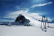
- Glacial zone
The glacial zone is the area of permanent snow and ice. When the steepness of the slope is not too high it results in an accumulation and compaction of snow, which transforms into ice. The glacier formed then flows down the valley and can reach as far down as 1,500 metres (the Upper Grindelwald Glacier
Upper Grindelwald Glacier
The Upper Grindelwald Glacier is one of the two valley glaciers south of Grindelwald on the northern side of the Bernese Alps, in the Canton of Berne...
). Where the slopes are too steep, the snow accumulates to form overhanging serac
Serac
A serac is a block or column of ice formed by intersecting crevasses on a glacier. Often house-sized or larger, they are dangerous to mountaineers since they may topple with little warning...
s, which periodically fall off due to the downwards movement of the glacier and cause ice avalanches. The Bernese Alps, Pennine Alps and Mont Blanc Massif contain most of the glaciated areas in the Alps. Except research stations such as the Sphinx Observatory
Sphinx Observatory
Sphinx Observatory is an observatory located on Jungfraujoch in Switzerland. The mountain top has been hollowed to fit an elevator that leads to the observatory from the train station and ice Palace.-External links:*...
no settlements are to be found in those regions.
Travel and tourism
Tourism in Switzerland
Tourists are drawn to Switzerland's Alpine climate and landscapes, in particular for skiing and mountaineering.As of 2006, tourism accounted for an estimated 3.6% of Switzerland's gross domestic product.- History :...
in the Swiss Alps began with the first ascents of the main peaks of the Alps (Jungfrau
Jungfrau
The Jungfrau is one of the main summits in the Bernese Alps, situated between the cantons of Valais and Bern in Switzerland...
in 1811, Piz Bernina
Piz Bernina
Piz Bernina is the highest mountain of the Eastern Alps and the highest point of the Bernina Range the highest peak in south Rhetic Alps. It is also the farthest easterly mountain higher than 4,000 m in the Alps, the highest point of the Swiss canton of Graubünden, and the fifth-most prominent...
in 1850, Monte Rosa
Monte Rosa
The Monte Rosa Massif is a mountain massif located in the eastern part of the Pennine Alps. It is located between Switzerland and Italy...
in 1855, Matterhorn
Matterhorn
The Matterhorn , Monte Cervino or Mont Cervin , is a mountain in the Pennine Alps on the border between Switzerland and Italy. Its summit is 4,478 metres high, making it one of the highest peaks in the Alps. The four steep faces, rising above the surrounding glaciers, face the four compass points...
in 1856, Dom
Dom (mountain)
The Dom is a mountain in the Pennine Alps above Saas Fee in the canton of Valais. With its summit it is the third highest peak in the Alps and the second highest in Switzerland...
in 1858, Weisshorn
Weisshorn
The Weisshorn is a mountain in the Pennine Alps, in Switzerland. With its summit, it is one of the major peaks in the Alps and overtops the nearby Matterhorn by some 30 metres. It was first climbed in 1861 from Randa by John Tyndall, accompanied by the guides J.J...
in 1861) mostly by British mountain climbers accompanied by the local guides. The construction of facilities for tourists started in the mid nineteenth century with the building of hotels and mountain huts (creation of the Swiss Alpine Club
Swiss Alpine Club
The Swiss Alpine Club is the largest mountaineering club in Switzerland. It was founded in 1863 in Olten and it is now composed of 111 sections with 110,000 members...
in 1863) and the opening of mountain train lines (Mount Rigi in 1873, Mount Pilatus in 1889, Gornergrat
Gornergrat
The Gornergrat is a ridge of the Pennine Alps, Switzerland, overlooking the Gorner Glacier to the south. It can be reached by the Gornergratbahn rack railway from Zermatt...
in 1898). The Jungfraubahn opened in 1912; it leads to the highest train station in Europe, the Jungfraujoch
Jungfraujoch
The Jungfraujoch is a col or saddle between the Mönch and the Jungfrau in the Bernese Alps on the boundary between the cantons of Bern and Valais, inside the Jungfrau-Aletsch Protected Area....
.
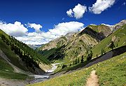
Summer tourism
Switzerland enjoys a 62,000-km network of well-maintained trails, of which 23,000 are located in mountainous areas. Many mountains attract a large number of alpinistAlpinist
Alpinist is a quarterly American magazine focused on mountaineering ascents worldwide. It was originally published out of Jackson, Wyoming and was founded in 2002...
s from around the world, especially the 4000-metre summits and the great north faces
Great north faces of the Alps
In mountaineering, the six great north faces of the Alps are known for their difficulty and great height. They are:*Cima Grande di Lavaredo*Eiger*Grandes Jorasses*Matterhorn*Petit Dru*Piz Badile...
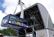
. The large winter resorts are also popular destinations in summer, as most of aerial tramways operate through the year, enabling hikers and mountaineers to reach high altitudes without much effort. The Klein Matterhorn
Klein Matterhorn
The Klein Matterhorn is the highest point in the Zermatt-Cervinia ski area in Switzerland, and the end point of the highest cable car in Europe...
is the highest summit of the European continent to be served by cable car.
Winter tourism
Skiing
Skiing is a recreational activity using skis as equipment for traveling over snow. Skis are used in conjunction with boots that connect to the ski with use of a binding....
and other winter sports are located in Valais
Valais
The Valais is one of the 26 cantons of Switzerland in the southwestern part of the country, around the valley of the Rhône from its headwaters to Lake Geneva, separating the Pennine Alps from the Bernese Alps. The canton is one of the drier parts of Switzerland in its central Rhône valley...
, Bernese Oberland
Bernese Oberland
The Bernese Oberland is the higher part of the canton of Bern, Switzerland, in the southern end of the canton: The area around Lake Thun and Lake Brienz, and the valleys of the Bernese Alps .The flag of the Bernese Oberland consists of a black eagle in a gold field The Bernese Oberland (Bernese...
and Graubünden
Graubünden
Graubünden or Grisons is the largest and easternmost canton of Switzerland. The canton shares borders with the cantons of Ticino, Uri, Glarus and St. Gallen and international borders with Italy, Austria and Liechtenstein...
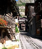
. Some villages are car-free and can be accessed only with public transports such as Riederalp
Riederalp
Riederalp is a municipality in the district of Raron in the canton of Valais in Switzerland. It was created in 2003 through the merger of Goppisberg, Greich and Ried-Mörel.-Geography:...
and Bettmeralp
Bettmeralp
Bettmeralp is a village and ski resort in the Swiss canton of Valais, 1'957 m above sea level, in the municipality of Betten.Bettmeralp is a car free village which can be reached by cable car from the Betten train station . From there another cable car leads near to the summit of Bettmerhorn, which...
. Zermatt
Zermatt
Zermatt is a municipality in the district of Visp in the German-speaking section of the canton of Valais in Switzerland. It has a population of about 5,800 inhabitants....
and Saas-Fee
Saas-Fee
Saas-Fee is the main village in the Saastal, or the Saas Valley, and is a municipality in the district of Visp in the canton of Valais in Switzerland...
have both summer ski areas. The most visited places are:
- DavosDavosDavos is a municipality in the district of Prättigau/Davos in the canton of Graubünden, Switzerland. It has a permanent population of 11,248 . Davos is located on the Landwasser River, in the Swiss Alps, between the Plessur and Albula Range...
- KlostersKlostersKlosters-Serneus is a municipality in the district of Prättigau/Davos in the Swiss canton of Graubünden.Its well-known ski resort lies from Zurich, the nearest international airport. Transfer time is about 1.5 hours. Klosters is from Davos... - ZermattZermattZermatt is a municipality in the district of Visp in the German-speaking section of the canton of Valais in Switzerland. It has a population of about 5,800 inhabitants....
(car-free village) - St. MoritzSt. MoritzSt. Moritz is a resort town in the Engadine valley in Switzerland. It is a municipality in the district of Maloja in the Swiss canton of Graubünden...
- GrindelwaldGrindelwaldGrindelwald is a municipality in the Interlaken-Oberhasli administrative district in the canton of Bern in Switzerland. The village is located at above sea level in the Bernese Alps.-Winter sports:...
- MürrenMürrenMürren is a traditional Walser mountain village in Bernese Oberland, Switzerland, at an elevation of 1,650 m above sea level and unreachable by public road....
- WengenWengenWengen may refer to:*Wengen, a village and winter resort in Switzerland*La Val, a commune in South Tyrol, Italy with the German name "Wengen"*in Germany:**Wengen , a village in the municipality of Nennslingen in Mittelfranken...
(car-free villages) - AdelbodenAdelbodenAdelboden is a municipality in the Frutigen-Niedersimmental administrative district in the Bernese Oberland in Switzerland.-Geography:Adelboden lies in the west of the Berner Oberland, at the end of the valley of the Engstlige river, which flows in Frutigen into the Kander river.Adelboden is a...
- LenkLenkLenk may refer to:Places:* Lenk im Simmental, a municipality in the district of Obersimmental in the canton of Bern in SwitzerlandPeople:* Arthur Lenk, an Israeli diplomat* Maria Lenk, a Brazilian swimmer... - VerbierVerbierVerbier is a village located in southwestern Switzerland in the canton of Valais. It is one of the largest holiday resort and ski areas in the Swiss Alps, is recognized as one of the premiere "off-piste" locations in the world...
- NendazNendazNendaz is a municipality in the district of Conthey in the canton of Valais in Switzerland.-History:Nendaz is first mentioned in 984 as Nenda. It was also known under its German name Neind though that name is no longer used.-Geography:... - GstaadGstaadGstaad is a village in the German-speaking section of the Canton of Berne in southwestern Switzerland. Part of the municipality of Saanen, Gstaad is known as one of the most exclusive ski resorts in the world....
- FlimsFlimsFlims is a municipality in the district of Imboden in the Swiss canton of Graubünden. The town of Flims is dominated by the Flimserstein which you can see from almost anywhere in the area....
- LaaxLaaxLaax is a municipality in the district of Surselva in the Swiss canton of Graubünden.-Geography:Laax has an area, , of . Of this area, 35.8% is used for agricultural purposes, while 30.6% is forested... - LenzerheideLenzerheideLenzerheide is a mountain resort in the canton of Graubünden, Switzerland. It lies at the foot of the Parpaner Rothorn. The village belongs to the municipality Vaz/Obervaz in the district of Albula, sub-district Alvaschein....
- ArosaArosaArosa is a town and a municipality in the district of Plessur in the canton of Graubünden in Switzerland. It is both a summer and a winter tourist resort.-History:... - Crans Montana
Other important destinations on the regional level are Engelberg
Engelberg
Engelberg is a village in the canton of Obwalden in Switzerland. Engelberg has a population of . , 21.0% of the population was made up of foreign nationals.It is the leading mountain resort in central Switzerland...
and Andermatt
Andermatt
Andermatt is a municipality in the canton of Uri in Switzerland.With Realp and Hospental, it is located in the Urseren valley, south of Altdorf.-Geography:...
(Central Switzerland), Leysin
Leysin
Leysin is a municipality of the canton of Vaud in Switzerland, located in the district of Aigle.-History:Leysin is first mentioned around 1231-32 as Leissins. In 1352 it was mentioned as Leisins.-Geography:...
(Vaud), Champéry
Champéry
Champéry is a municipality in the district of Monthey in the canton of Valais in Switzerland.-History:Champéry is first mentioned in 1286 as Champery...
(western Valais) and Samnaun
Samnaun
Samnaun is a municipality in the district of Inn in the Swiss canton of Graubünden.-History:The valley was first used as a seasonal mountain pasture for the villages of Tschlin and Ramosch. By 1220 the first permanent farm houses are mentioned...
(eastern Graubünden).
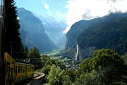
Transportation
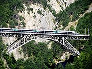
Transport in Switzerland
Being in the centre of Europe, Switzerland has a dense network of roads and railways. The crossing of the Alps is an important route for European transportation, as the Alps separate Switzerland from some of its neighbours. Alpine railway routes began in 1882 with the Gotthard Rail Tunnel, followed...
. Every mountain village can be reached by public transport
Rail transport in Switzerland
The railways of Switzerland include and narrow gauge .*Network size: 5,063 km*standard gauge: , of which is electrified.*narrow gauge: , of which is electrified...
, the main companies are:
- Federal RailwaySBB-CFF-FFSSwiss Federal Railways and SFR are not in official use) is the national railway company of Switzerland headquartered in Bern. Formerly a government institution, it is since 1999 a special stock corporation with all shares held by the Swiss Confederation or the Swiss cantons...
- Rhaetian RailwayRhBThe Rhaetian Railway is a Swiss transport company, owning the largest network of all the private railways in Switzerland. The company operates most of the railways in the Swiss canton of Graubünden as the Swiss federal railway company SBB-CFF-FFS extend only a few kilometres over the cantonal...
- Matterhorn Gotthard Bahn
- Golden PassGolden PassThe GoldenPass Line is a train line in the Swiss Alps which connects Montreux to Lucerne. The line is served by three companies with panoramic trains:*Montreux-Oberland Bernois: From Montreux to Zweisimmen via Gstaad...
- PostBusPostBusPostauto, also called Poschi or Poschti in Swiss German dialect, is the Swiss Standard German term used in Switzerland for the motorized successor to stagecoaches. This linguistic anomaly also exists in the French and Italian-speaking parts of the country, where the terms Car postal and...
Most of mountain regions are within 3 hours travel of Switzerland’s main cities and their respective airport. The Engadin
Engadin
The Engadin or Engadine is a long valley in the Swiss Alps located in the canton of Graubünden in southeast Switzerland. It follows the route of the Inn River from its headwaters at Maloja Pass running northeast until the Inn flows into Austria one hundred kilometers downstream...
Valley in Graubünden
Graubünden
Graubünden or Grisons is the largest and easternmost canton of Switzerland. The canton shares borders with the cantons of Ticino, Uri, Glarus and St. Gallen and international borders with Italy, Austria and Liechtenstein...
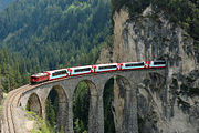
is between 4 to 6 hours away from the large cities; the train journey itself, with the panoramic Glacier Express
Glacier Express
The Glacier Express is an express train connecting railway stations of the two major mountain resorts of St. Moritz and Zermatt in the Swiss Alps. The train is operated jointly by the Matterhorn Gotthard Bahn and Rhaetian Railway...
or Bernina Express
Bernina Express
The Bernina Express is an express train connecting Chur in Switzerland with Poschiavo and Tirano in Italy, by crossing the Swiss Alps from north to south. For most of its journey, the train also passes along and through the World Heritage Site known as the Rhaetian Railway in the Albula / Bernina...
, is popular with tourists.
The Engadin Airport near St. Moritz
St. Moritz
St. Moritz is a resort town in the Engadine valley in Switzerland. It is a municipality in the district of Maloja in the Swiss canton of Graubünden...
at an altitude of 1,707 metres (5,600 ft) is the highest in Europe.
The crossing of the Alps is a key issue at national and international levels, as the European continent is at places divided by the range. Since the beginnings of industrialization Switzerland has improved its transalpine network; it began in 1882, by building the Gotthard Rail Tunnel
Gotthard Rail Tunnel
The Gotthard Rail Tunnel, is a 15-kilometre long railway tunnel and forms the summit of the Gotthard Railway in Switzerland. It connects Göschenen with Airolo and was the first tunnel through the Gotthard massif...
, followed in 1906 by the Simplon Tunnel
Simplon Tunnel
The Simplon Tunnel is an Alpine railway tunnel that connects the Swiss town of Brig with Domodossola in Italy, though its relatively straight trajectory does not run under Simplon Pass itself. It actually consists of two single-track tunnels built nearly 20 years apart...
and more recently, in 2007, by the Lötschberg Base Tunnel
Lötschberg Base Tunnel
The Lötschberg Base Tunnel is a railway tunnel on the BLS Lötschbergbahn's Lötschberg Line cutting through the Alps of Switzerland some below the existing Lötschberg Tunnel. It is currently the world's longest land tunnel and accommodates passenger and freight trains. It runs between Frutigen,...
. The 57-km long Gotthard Base Tunnel
Gotthard Base Tunnel
The Gotthard Base Tunnel is a new railway tunnel beneath the Swiss Alps, expected to open in 2016. With a route length of and a total of of tunnels, shafts and passages, it is the world's longest rail tunnel, surpassing the Japanese Seikan Tunnel....
is slated to be open in 2016, and it will finally provide a direct flat rail link through the Alps.
Toponymy
The different names of the mountains and other landforms are named in the four national languagesLinguistic geography of Switzerland
The four national languages of Switzerland are German, French, Italian, and Romansh. Only three of these languages, however, maintain equal status as official languages at the national level within the Federal Administration of the Swiss Confederation: German, French, and Italian.Native speakers...
. The table below gives the most recurrent names.
| English English language English is a West Germanic language that arose in the Anglo-Saxon kingdoms of England and spread into what was to become south-east Scotland under the influence of the Anglian medieval kingdom of Northumbria... |
German German language German is a West Germanic language, related to and classified alongside English and Dutch. With an estimated 90 – 98 million native speakers, German is one of the world's major languages and is the most widely-spoken first language in the European Union.... |
French French language French is a Romance language spoken as a first language in France, the Romandy region in Switzerland, Wallonia and Brussels in Belgium, Monaco, the regions of Quebec and Acadia in Canada, and by various communities elsewhere. Second-language speakers of French are distributed throughout many parts... |
Italian Italian language Italian is a Romance language spoken mainly in Europe: Italy, Switzerland, San Marino, Vatican City, by minorities in Malta, Monaco, Croatia, Slovenia, France, Libya, Eritrea, and Somalia, and by immigrant communities in the Americas and Australia... |
Romansh | Examples |
|---|---|---|---|---|---|
| Mount | Berg, Stock | Mont | Monte | Munt | Gamsberg Gamsberg The Gamsberg is a mountain in the Appenzell Alps, overlooking the region of Walenstadt in the canton of St. Gallen. Located in the Alvier group it is the culminating point of the range lying between Lake Walenstadt and Toggenburg.... , Dammastock Dammastock The Dammastock is the highest mountain in the Urner Alps in Switzerland. Its summit ridge forms the border between the cantons of Uri and the Valais. It is the highest summit in the canton of Uri... , Mont Vélan Mont Vélan Mont Vélan is a mountain in the Pennine Alps, located on the border between Switzerland and Italy. At 3,727, metres Mont Vélan is the highest summit lying between the Great St Bernard Pass and Grand Combin. Two large glaciers cover its northern flanks: Glacier de Tseudet and Glacier de Valsoray... , Monte Generoso Monte Generoso The Monte Generoso is a mountain in Switzerland, located in the Lepontine Alps,between Lake Lugano and Lake Como. The western and southern flanks of the mountain lie in the Swiss canton of Ticino, whilst the north-eastern flanks are in the Italian region of Lombardy... , Munt Pers Munt Pers The Munt Pers is a mountain in the Bernina Range , located in Graubünden, Switzerland. The mountain lies north of Diavolezza.-External links:*... |
| Summit | Gipfel | Cime | Cima | Tschima | Grenzgipfel Grenzgipfel The Grenzgipfel is a subpeak of Monte Rosa, in Italy and Switzerland. In the German language the peak's name means 'frontier summit'.... , Cima di Gana Bianca Cima di Gana Bianca Cima di Gana Bianca is a mountain in the Lepontine Alps in Switzerland.-External links:*... , Tschima da Flix Tschima da Flix The Tschima da Flix is a mountain in the Albula Range, located in Graubünden, Switzerland.-External links:*... |
| Peak | Spitze | Pointe, Pic | Pizzo | Piz, Péz | Lenzspitze Lenzspitze The Lenzspitze is a mountain in the Pennine Alps in Switzerland. It is the southernmost peak on the Nadelgrat, a high-level ridge running roughly north–south, north of Dom in the Mischabel range, above the resort of Saas Fee to the east, and the Mattertal to the west.It was first climbed in August... , Pointe de Zinal Pointe de Zinal Pointe de Zinal is a mountain in the Pennine Alps in Switzerland. It is located east of Dent Blanche between the valleys of Zinal and Zmutt.... , Pizzo Campo Tencia, Piz Roseg Piz Roseg Piz Roseg is a mountain in the Bernina Range in Graubünden, Switzerland.There are two summits on its main ridge:*the south-east and higher summit *the north-west summit, known as the Schneekuppe .... |
| Needle | Nadel | Aiguille | Ago | Ago | Nadelhorn Nadelhorn The Nadelhorn is a mountain in the Pennine Alps in Switzerland. It is the highest point on the Nadelgrat, a high-level ridge running roughly north–south above the resort of Saas-Fee to the east, and the Mattertal to the west. Its three ridges join to form a sharp-pointed summit, which looks like a... , Aiguille d'Argentière Aiguille d'Argentière The Aiguille d'Argentière is a mountain in the Mont Blanc massif on the border between France and Switzerland.The first ascent of the mountain was by a British party comprising Edward Whymper and A. Reilly with guides Michel Croz, M. Payot, H. Charlet on 15 July 1864... , Ago di Sciora Ago di Sciora Ago di Sciora is a mountain in the Bregaglia Range , located in Graubünden, Switzerland. It forms a sharp needle in the middle of the Sciora group.-External links:*... |
| Horn | Horn | Corne | Corno | Corn | Wetterhorn Wetterhorn The Wetterhorn is a mountain in the Swiss Alps close to the village of Grindelwald. First climbed in 1844, the 1854 ascent by Alfred Wills and party is more celebrated and is generally regarded to have marked the beginning of the golden age of alpinism.The mountain is composed of three distinct... , Corne de Sorebois Corne de Sorebois The Corne de Sorebois is a mountain in the Pennine Alps in Switzerland. It is located near Zinal in Valais. Sorebois is the name of an alpine pasture on the east slopes of the mountain.-External links:*... , Corn da Tinizong Corn da Tinizong The Corn da Tinizong is a mountain in the Albula Range, located in Graubünden, Switzerland.-External links:*... |
| Tower | Turm | Tour | Torre | Tuor | Tour Sallière Tour Sallière The Tour Sallière is a mountain in the Chablais Alps in Switzerland.-External links:*... , Torrone Alto |
| Head | Kopf | Tête | Testa | Tgau | Bürkelkopf Bürkelkopf Bürkelkopf is a mountain in the Samnaun Alps, located on the border between Austria and Switzerland.-External links:*... , Tête Blanche Tête Blanche Tête Blanche is a mountain in the Pennine Alps on the Swiss-Italian border. It is generally the high point of the Haute route between Chamonix and Zermatt and the annually race Patrouille des Glaciers. Tête Blanche lies within a few kilometres of the Matterhorn and Dent d'Hérens on the... |
| Ridge | Grat | Crêt | Cresta | Fil, Cresta | Gornergrat Gornergrat The Gornergrat is a ridge of the Pennine Alps, Switzerland, overlooking the Gorner Glacier to the south. It can be reached by the Gornergratbahn rack railway from Zermatt... , Crêt du Midi Crêt du Midi The Crêt du Midi is a mountain in the Pennine Alps in Switzerland.-External links:*... , Fil de Cassons Fil de Cassons Fil de Cassons is a mountain in the Glarus Alps, located near Flims in the canton of Graubünden, Switzerland.The southern face is referred to as "Flimserstein" , dominating the appearance of the town of Flims... |
| Glacier | Gletscher, Firn | Glacier | Ghiacciaio | Glatscher, Vadret | Unteraargletscher, Hüfifirn, Glacier de Corbassière, Ghiacciaio del Basodino, Vadret da Morteratsch, Glatscher dil Vorab |
| Valley | Tal | Val | Valle, Val | Val | Mattertal Mattertal The Matter Valley is located in southwestern Switzerland, south of the Rhone valley in the canton of Valais. The village of Zermatt is the most important settlement of the valley, which is surrounded by many four-thousanders, including the Matterhorn.-Geography:Located in the Pennine Alps, the... , Val d'Hérens Val d'Hérens Val d'Hérens is an alpine valley in the Valais canton of Switzerland. It was formed by the Hérens glacier, which retreated at the end of the last ice age.... , Valle Maggia Valle Maggia Valle Maggia is an alpine valley of the Maggia River in Ticino, the Italian canton of Switzerland.The valley is dotted with small picturesque villages with traditional stone houses, vineyards and dairy farms... |
| Pass | Pass, Joch | Col, Pas | Passo | Pass | Jungfraujoch Jungfraujoch The Jungfraujoch is a col or saddle between the Mönch and the Jungfrau in the Bernese Alps on the boundary between the cantons of Bern and Valais, inside the Jungfrau-Aletsch Protected Area.... , Panix Pass Panix Pass Panix Pass or Panixer Pass is a Swiss Alpine pass in the canton of Graubünden.... , Pas de Cheville Pas de Cheville The Pas de Cheville is a high mountain pass across the western Bernese Alps, connecting Gryon in the canton of Vaud in Switzerland and Derborence in the canton of Valais.... , Passo del San Gottardo |
Also a large number of peaks outside the Alps were named or nicknamed after Swiss mountains, such as the Wetterhorn Peak
Wetterhorn Peak
Wetterhorn Peak is a fourteen thousand foot mountain peak in the U.S. state of Colorado. It is located in the Uncompahgre Wilderness of the northern San Juan Mountains, in northwestern Hinsdale County and southeastern Ouray County, east of the town of Ouray...
in Colorado
Colorado
Colorado is a U.S. state that encompasses much of the Rocky Mountains as well as the northeastern portion of the Colorado Plateau and the western edge of the Great Plains...
or the Matterhorn Peak
Matterhorn Peak
Matterhorn Peak is located in the Sierra Nevada, in the western U.S. state of California, at the northern boundary of Yosemite National Park. At elevation, it is the tallest peak in the craggy Alps-like Sawtooth Ridge and the northernmost peak in the Sierra Nevada. The peak also supports the...
in California
California
California is a state located on the West Coast of the United States. It is by far the most populous U.S. state, and the third-largest by land area...
(see the Matterhorn article for a list of Matterhorns in the world).
The confluence of the Baltoro Glacier
Baltoro Glacier
The Baltoro Glacier, at 62 kilometers long, is one of the longest glaciers outside the polar regions. It is located in Baltistan, in the Gilgit-Baltistan region of Pakistan, and runs through part of the Karakoram mountain range. The Baltoro Muztagh lies to the north and east of the glacier, while...
and the Godwin-Austen Glacier
Godwin-Austen Glacier
The Godwin-Austen Glacier is located near K2 in the Gilgit-Baltistan region of Pakistan. Its confluence with the Baltoro Glacier is called Concordia and is one of the most favorite spots for trekking in Pakistan since it provides excellent views of four of the five eight-thousanders in Pakistan.The...
south of K2
K2
K2 is the second-highest mountain on Earth, after Mount Everest...
in the Karakoram
Karakoram
The Karakoram, or Karakorum , is a large mountain range spanning the borders between Pakistan, India and China, located in the regions of Gilgit-Baltistan , Ladakh , and Xinjiang region,...
range was named after the Konkordiaplatz
Konkordiaplatz
The Konkordiaplatz or Concordia , is a large flat area of snow and ice lying just to the south of the Jungfrau in the Bernese Alps in the Swiss canton of Valais. Its notable feature is that it is the junction of four large glaciers coming down from the Aletschfirn, the Jungfraufirn, the...
by European explorers.
See also
Tourism- Swiss Alpine ClubSwiss Alpine ClubThe Swiss Alpine Club is the largest mountaineering club in Switzerland. It was founded in 1863 in Olten and it is now composed of 111 sections with 110,000 members...
- Swiss Alpine MuseumSwiss Alpine MuseumThe Swiss Alpine Museum is a museum dedicated to the nature and culture of the Swiss Alps. It is located at Helvetiaplatz 4 in Bern.-History:...
- Haute RouteHaute RouteThe Haute Route, is the name given to a route undertaken on foot or by ski touring between Chamonix, France, and Zermatt, Switzerland....
- Tour du Mont BlancTour du Mont BlancThe Tour du Mont Blanc or TMB is one of the most popular long distance walks in Europe. It circles the Mont Blanc Massif covering a distance of roughly 170 km with 10 km of ascent/descent and passes through parts of Switzerland, Italy and France.It is considered one of the classic long...
- Monte Rosa tourMonte Rosa tourThe Monte Rosa Tour is a circular hiking trail through the Swiss & Italian Alps around Monte Rosa . The tour also encircles the Dom in the Mischabel range.Typical overnight stops are* Zermatt* Theodulpass...
- Alpine Pass RouteAlpine Pass RouteThe Alpine Pass Route is a long-distance hiking trail through the Alps in Switzerland. It starts in Sargans in eastern Switzerland, and crosses the heart of country westwards to finish in Montreux on the shore of Lake Geneva...
- Trans-Swiss TrailTrans-Swiss TrailThe Trans-Swiss Trail is a long-distance hiking trail in Switzerland. It starts in Porrentruy in the north near the French border, and cuts south over the Alps to finish in Lugano....
Sport
- Patrouille des GlaciersPatrouille des GlaciersThe Patrouille des Glaciers is a ski mountaineering race organized every two years by the Swiss Army, in which military and civilian teams compete...
- Lauberhorn Ski RaceLauberhornThe Lauberhorn is a mountain in the Bernese Alps of Switzerland, located between Wengen and Grindelwald. Its summit is at an elevation of 8110 feet above sea level....
- Trophée des GastlosenTrophée des GastlosenThe Trophée des Gastlosen is a Swiss competition of ski mountaineering, which is carried out annually in the region of Charmey since 1993...
- Jungfrau MarathonJungfrau MarathonThe Jungfrau Marathon is one of the best known mountain marathons in the world, in full view of the famous Eiger, Mönch, and Jungfrau mountains in the Bernese Oberland area of the Swiss Alps....
Other
- The AlpsThe AlpsThe Alps is a 2007 American documentary film about the climbing of the north face of the Eiger in the Bernese Alps by John Harlin III, son of John Harlin who died on the same ascent 40 years earlier...
(film) - History of the AlpsHistory of the AlpsThe Alpine region has been populated since ancient times and, due to its central location, its history has always been closely entwined with that of Europe. Currently the Alps sprawl across eight countries...
- Transhumance in the AlpsTranshumance in the AlpsTranshumance in the Alps, or seasonal migration between valley and high pastures is a traditional practice that has shaped much of the landscape in the Alps, as without it, most areas below 2000 m would be forests.While tourism and industry contribute today much to Alpine economy, seasonal...
- AlpTransitAlpTransitAlpTransit, also known as New Railway Link through the Alps NRLA , is a Swiss federal project aimed to build faster north-south rail links across the Swiss Alps by constructing base tunnels several hundred metres below the level of the current tunnels...
- Exploration of the High AlpsExploration of the High AlpsThe higher region of the Alps were long left to the exclusiveattention of the men of the adjoining valleys, even when Alpine travellers began to visit these valleys. It is reckoned that about 20 glacier passes were certainly known before 1600, about 25 more before 1700, and yet another 20 before...
External links
Tourism- General timetable of all public transport
- MySwitzerland.com
- SuisseMobile.com
- Scenic PostBus lines in the Swiss Alps
- MySwissAlps.com
- WalkingSwitzerland.com
Maps
Other