
.gif)
Hawaii (island)
Encyclopedia
The Island of Hawaii, also called the Big Island or Hawaii Island (icon or h; Hawaiian: həˈwɐiʔi or həˈvɐiʔi), is a volcanic
island
(the eastern-most and southern-most in the Hawaiian islands
chain) in the North Pacific Ocean. With an area of 4028 square miles (10,432.5 km²), it is larger than all of the other Hawaiian Islands combined and is the largest island in the United States.
The Island of Hawaii is administered as the County of Hawaii
within the state of Hawaii
. The county seat is Hilo.
In modern times, Hawaii is known as the "Big Island" to reduce confusion between Hawaii Island and the state.
, a place from which the Polynesia
ns originated (see also Manua
), the place where they go in the afterlife, the realm of the gods and goddesses.
Captain James Cook
, who called them the "Sandwich Islands", was killed on the Big Island at Kealakekua Bay
.
Hawaii was the home island of Paiea Kamehameha, called Kamehameha the Great
, who by 1795 united most of the Hawaiian Islands under his rule after several years of war. He gave his Kingdom of Hawaii
the name of his native island, and the islands in chain are known collectively as "Hawaiian Islands
".
has a land area of 4028 square miles (10,432.5 km²) comprising 62% of the Hawaiian Islands
' land area. Measured from its sea floor base to its peak, Mauna Kea
is the world's tallest mountain, taller than Mount Everest
.
es that erupted somewhat sequentially, one overlapping the other. These are (from oldest to youngest):
Geological evidence from exposures of old surfaces on the south and west flanks of Mauna Loa led to the proposal that two ancient volcanic shields (named Ninole and Kulani) were all but buried by the younger Mauna Loa. Geologists now consider these "outcrops" to be part of the earlier building of Mauna Loa. Another volcano which already disappeared below the surface of the ocean is Māhukona
.
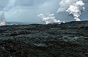
Because Mauna Loa and Kīlauea are active volcanoes, the island of Hawaii is still growing. Between January 1983 and September 2002, lava
flows added 543 acres (219.7 ha) to the island. Lava flowing from Kīlauea has destroyed several towns, including Kapoho
in 1960, and Kalapana and Kaimū in 1990. In 1987 lava filled in Queen's Bath, a large, L-shaped, freshwater pool in the Kalapana area.
 The southernmost point
in the United States, Ka Lae
, is on Hawaii. The nearest landfall to the south would be in the Line Islands
. To the north is the island of Maui
, whose Haleakalā
volcano is visible from Hawaii across the Alenuihāhā Channel
.
Approximately 35 km (21.7 mi) southeast of Hawaii lies the undersea volcano
known as Lōihi
. Lōihi is an erupting seamount that reaches 3200 feet (975.4 m) below the ocean surface. Continued activity from Lōihi will likely cause it to breach the surface of the ocean 10,000–100,000 years from now.
. According to the United States Geological Survey, The Great Crack is the result of crustal dilation from magmatic intrusions into the southwest rift zone of Kilauea. While neither substantial earthquakes 1868 and 1975 caused a measurable change in The Great Crack, lava welled out of the lower 10 kilometres (6.2 mi) of the Great Crack in 1823.
One can find trails, rock walls, and archaeological sites from as old as the 12th century around the Great Crack. Approximately 1951 acres (7.9 km²) of private land were purchased during the Presidency of Bill Clinton
, specifically to protect various artifacts in this area as well as the habitat of local wildlife.
is a 4760 cubic miles (19,840.5 km³) chunk of the south slope of the Kīlauea volcano which is slipping away from the island. Between 1990 and 1993, Global Positioning System
measurements showed a southward displacement up to approximately 10 centimeters per year. Undersea measurements show that a "bench" has formed a buttress and that this buttress may tend to reduce the likelihood of future catastrophic detachment.
with a magnitude estimated between 7.25 and 7.75 on the Richter scale rocked the southeast coast of Hawaii. It triggered a landslide on Mauna Loa, five miles (8 km) north of Pahala, killing 31 people. A tsunami
claimed 46 additional lives. The villages of Punaluu, Nīnole, Kawaa, Honuapo, and Keauhou Landing were severely damaged. The tsunami was reported to roll over the tops of the coconut trees, up to 60 feet (18 m) high, and reach inland a distance of a quarter of a mile in some places.
On November 29, 1975, a 37 miles (60 km) wide section of the Hilina Slump
dropped 11.5 feet (3.5 m) and slid 26 feet (7.9 m) toward the ocean. This movement caused a 7.2 magnitude earthquake and a 48 feet (14.6 m) high tsunami. Oceanfront properties were washed off their foundations in Punaluu. Two deaths were reported at Halapē, and 19 others were injured.
The island suffered tsunami damage from earthquakes in Chile
in 1946 and Alaska
on 27 March 1964. Downtown Hilo was severely damaged in both, with many lives lost. Just north of Hilo, Laupāhoehoe lost 16 school children and 5 teachers in the 1946 tsunami.
In March 2011 a 9.0 magnitude earthquake
off the east coast of Japan again created a tsunami that caused significant damage in Hawaii. The estimated damage to public infrastructure alone was $3 million.
, there were 148,677 people, 52,985 households, and 36,877 families residing in the county. The population density
was 14/km² (37/mi²). There were 62,674 housing units at an average density of 6/km² (16/mi²). The racial makeup of the county was 31.55% White
, 0.47% African American
, 0.45% Kanaka Maoli
, 26.70% Asian
, 11.25% Pacific Islander
, 1.14% from other races, and 28.44% from two or more races. 9.49% of the population were Hispanics or Latinos
of any race.
There were 52,985 households out of which 32.20% had children under the age of 18 living with them, 50.60% were married couples
living together, 13.20% had a woman whose husband did not live with her, and 30.40% were non-families. 23.10% of all households were made up of individuals and 8.00% had someone living alone who was 65 years of age or older. The average household size was 2.75 and the average family size was 3.24.
The age distribution was 26.10% under 18, 8.20% from 18 to 24, 26.20% from 25 to 44, 26.00% from 45 to 64, and 13.50% who were 65 or older. The median age was 39 years. For every 100 females there were 100 males. For every 100 females age 18 and over, there were 98 males.
was the backbone of Hawaii Island's economy
for more than a century (see Sugar plantations in Hawaii
). In the mid-twentieth century, sugar plantation
s began to downsize and in 1996, the last plantation closed.
Most of Hawaii Island's economy is based on tourism
(see Tourism in Hawaii
), centered primarily in resort areas on the western coast of the island in the North Kona
and South Kohala
districts. More recently, Hawaii Island has become a focus for sustainable tourism
.
Diversified agriculture
is a growing sector of the economy. Major crops include Macadamia nuts
, papaya
, flower
s, tropical and temperate
vegetable
s, and coffee beans
. Only coffee grown in the Kona District
of this island may be branded Kona coffee
. The island's orchid agriculture is the largest in the state, and resulted in the unofficial nickname "The Orchid Isle." The island is home to one of the United States' largest cattle ranches: Parker Ranch
, on 175000 acres (708 km²) in Waimea. Hawaii is also known for Astronomy
, and numerous telescope
s are operated on the summit of Mauna Kea
, where atmospheric clarity is excellent and there is little light pollution
.
, Hilo, Hāmākua, Kohala
, Kona
, and Kaū
. The county government
subdivides some of these to form elective districts of the county council. There are no incorporated municipalities on the island. Some of the named towns include:
There are also State highways 270 (Kawaihae
- Hawi) and 180 (the "Kona coffee
road", from Honalo to State highway 190), Saddle Road (Hilo to Waimea, passing between Mauna Loa
and Mauna Kea
), South Point Road (Highway 11 to South Point
), etc.
Rental car offices are at the international airports. Taxi
service is also available. Island-wide zero-fare public transport
is provided by the "Hele-On Bus".
There is also:
Volcano
2. Bedrock3. Conduit 4. Base5. Sill6. Dike7. Layers of ash emitted by the volcano8. Flank| 9. Layers of lava emitted by the volcano10. Throat11. Parasitic cone12. Lava flow13. Vent14. Crater15...
island
Island
An island or isle is any piece of sub-continental land that is surrounded by water. Very small islands such as emergent land features on atolls can be called islets, cays or keys. An island in a river or lake may be called an eyot , or holm...
(the eastern-most and southern-most in the Hawaiian islands
Hawaiian Islands
The Hawaiian Islands are an archipelago of eight major islands, several atolls, numerous smaller islets, and undersea seamounts in the North Pacific Ocean, extending some 1,500 miles from the island of Hawaii in the south to northernmost Kure Atoll...
chain) in the North Pacific Ocean. With an area of 4028 square miles (10,432.5 km²), it is larger than all of the other Hawaiian Islands combined and is the largest island in the United States.
The Island of Hawaii is administered as the County of Hawaii
Hawaii County, Hawaii
Hawaii County is a county located in the U.S. state of Hawaii in the Hawaiian Islands. It is coterminous with the Island of Hawaii, often called the "Big Island" to distinguish it from the state as a whole. As of the 2010 Census the population was 185,079. The county seat is Hilo. There are no...
within the state of Hawaii
Hawaii
Hawaii is the newest of the 50 U.S. states , and is the only U.S. state made up entirely of islands. It is the northernmost island group in Polynesia, occupying most of an archipelago in the central Pacific Ocean, southwest of the continental United States, southeast of Japan, and northeast of...
. The county seat is Hilo.
In modern times, Hawaii is known as the "Big Island" to reduce confusion between Hawaii Island and the state.
History
Hawaii is said to have been named for Hawaiʻiloa, the legendary Polynesian navigator who first discovered it. Other accounts attribute the name to the legendary realm of HawaikiHawaiki
In Māori mythology, Hawaiki is the homeland of the Māori, the original home of the Māori, before they travelled across the sea to New Zealand...
, a place from which the Polynesia
Polynesia
Polynesia is a subregion of Oceania, made up of over 1,000 islands scattered over the central and southern Pacific Ocean. The indigenous people who inhabit the islands of Polynesia are termed Polynesians and they share many similar traits including language, culture and beliefs...
ns originated (see also Manua
Manua
Manua, or the Manua Islands Group , in the Samoan Islands, consists of three main islands: Tau, Ofu and Olosega...
), the place where they go in the afterlife, the realm of the gods and goddesses.
Captain James Cook
James Cook
Captain James Cook, FRS, RN was a British explorer, navigator and cartographer who ultimately rose to the rank of captain in the Royal Navy...
, who called them the "Sandwich Islands", was killed on the Big Island at Kealakekua Bay
Kealakekua Bay
Kealakekua Bay is located on the Kona coast of the island of Hawaii about south of Kailua-Kona.Settled over a thousand years ago, the surrounding area contains many archeological and historical sites such as religious temples, and was listed in the National Register of Historic Places listings on...
.
Hawaii was the home island of Paiea Kamehameha, called Kamehameha the Great
Kamehameha I
Kamehameha I , also known as Kamehameha the Great, conquered the Hawaiian Islands and formally established the Kingdom of Hawaii in 1810. By developing alliances with the major Pacific colonial powers, Kamehameha preserved Hawaii's independence under his rule...
, who by 1795 united most of the Hawaiian Islands under his rule after several years of war. He gave his Kingdom of Hawaii
Kingdom of Hawaii
The Kingdom of Hawaii was established during the years 1795 to 1810 with the subjugation of the smaller independent chiefdoms of Oahu, Maui, Molokai, Lānai, Kauai and Niihau by the chiefdom of Hawaii into one unified government...
the name of his native island, and the islands in chain are known collectively as "Hawaiian Islands
Hawaiian Islands
The Hawaiian Islands are an archipelago of eight major islands, several atolls, numerous smaller islets, and undersea seamounts in the North Pacific Ocean, extending some 1,500 miles from the island of Hawaii in the south to northernmost Kure Atoll...
".
Geology and geography
In greatest dimension, the island is 93 miles (149.7 km) across andhas a land area of 4028 square miles (10,432.5 km²) comprising 62% of the Hawaiian Islands
Hawaiian Islands
The Hawaiian Islands are an archipelago of eight major islands, several atolls, numerous smaller islets, and undersea seamounts in the North Pacific Ocean, extending some 1,500 miles from the island of Hawaii in the south to northernmost Kure Atoll...
' land area. Measured from its sea floor base to its peak, Mauna Kea
Mauna Kea
Mauna Kea is a volcano on the island of Hawaii. Standing above sea level, its peak is the highest point in the state of Hawaii. However, much of the mountain is under water; when measured from its oceanic base, Mauna Kea is over tall—significantly taller than Mount Everest...
is the world's tallest mountain, taller than Mount Everest
Mount Everest
Mount Everest is the world's highest mountain, with a peak at above sea level. It is located in the Mahalangur section of the Himalayas. The international boundary runs across the precise summit point...
.
Volcanism
The Island of Hawaii is built from five separate shield volcanoShield volcano
A shield volcano is a type of volcano usually built almost entirely of fluid lava flows. They are named for their large size and low profile, resembling a warrior's shield. This is caused by the highly fluid lava they erupt, which travels farther than lava erupted from more explosive volcanoes...
es that erupted somewhat sequentially, one overlapping the other. These are (from oldest to youngest):
- KohalaKohala (mountain)Kohala is the oldest of five volcanoes that make up the island of Hawaii. Kohala is an estimated one million years old—so old that it experienced, and recorded, a reversal of magnetic field 780,000 years ago. It is believed to have breached sea level more than 500,000 years ago and to...
—extinct - Mauna KeaMauna KeaMauna Kea is a volcano on the island of Hawaii. Standing above sea level, its peak is the highest point in the state of Hawaii. However, much of the mountain is under water; when measured from its oceanic base, Mauna Kea is over tall—significantly taller than Mount Everest...
—dormant - HualālaiHualalaiHualālai is a dormant shield volcano on the island of Hawaii in the Hawaiian Islands. It is the third-youngest and the third most active of the five volcanoes that form the island of Hawaii, following Kīlauea and the much larger Mauna Loa, and also the westernmost. Its peak is above sea...
—active but not currently erupting - Mauna LoaMauna LoaMauna Loa is one of five volcanoes that form the Island of Hawaii in the U.S. state of Hawaii in the Pacific Ocean, and the largest on Earth in terms of volume and area covered. It is an active shield volcano, with a volume estimated at approximately , although its peak is about lower than that...
—active, partly within Hawaii Volcanoes National ParkHawaii Volcanoes National ParkHawaii Volcanoes National Park, established in 1916, is a United States National Park located in the U.S. State of Hawaii on the island of Hawaii. It encompasses two active volcanoes: Kīlauea, one of the world's most active volcanoes, and Mauna Loa, the world's most massive volcano... - KīlaueaKilaueaKīlauea is a volcano in the Hawaiian Islands, and one of five shield volcanoes that together form the island of Hawaii. Kīlauea means "spewing" or "much spreading" in the Hawaiian language, referring to its frequent outpouring of lava. The Puu Ōō cone has been continuously erupting in the eastern...
—active: has been erupting continuously since 1983; part of Hawaii Volcanoes National Park
Geological evidence from exposures of old surfaces on the south and west flanks of Mauna Loa led to the proposal that two ancient volcanic shields (named Ninole and Kulani) were all but buried by the younger Mauna Loa. Geologists now consider these "outcrops" to be part of the earlier building of Mauna Loa. Another volcano which already disappeared below the surface of the ocean is Māhukona
Mahukona
Māhukona is a submerged shield volcano on the northwestern flank of the Island of Hawaii. A drowned coral reef at about 3,770 feet below sea level and a major break in slope at about 4,400 feet below sea level represent old shorelines. The summit of the shield volcano was once 800 feet above...
.
Because Mauna Loa and Kīlauea are active volcanoes, the island of Hawaii is still growing. Between January 1983 and September 2002, lava
Lava
Lava refers both to molten rock expelled by a volcano during an eruption and the resulting rock after solidification and cooling. This molten rock is formed in the interior of some planets, including Earth, and some of their satellites. When first erupted from a volcanic vent, lava is a liquid at...
flows added 543 acres (219.7 ha) to the island. Lava flowing from Kīlauea has destroyed several towns, including Kapoho
Kapoho, Hawai'i
Kapoho, Hawaii was a town in Puna district, Hawaii County, Hawaii, located near the eastern tip of the island of Hawaii, in the easternmost end of the graben overlying Kīlauea's east rift zone.-Eruption of January 1960:...
in 1960, and Kalapana and Kaimū in 1990. In 1987 lava filled in Queen's Bath, a large, L-shaped, freshwater pool in the Kalapana area.
Extreme points of the United States
This is a list of the extreme points of the United States, the points that are farther north, south, east, or west than any other location in the country. Also included are extreme points in elevation, extreme distances, and other points of peculiar geographic interest.-Northernmost:*Point Barrow,...
in the United States, Ka Lae
Ka Lae
Ka Lae , also known as South Point, is the southernmost point of the Big Island of Hawaii and of the 50 United States. The Ka Lae area is registered as a National Historic Landmark District under the name South Point Complex...
, is on Hawaii. The nearest landfall to the south would be in the Line Islands
Line Islands
The Line Islands, Teraina Islands or Equatorial Islands, is a chain of eleven atolls and low coral islands in the central Pacific Ocean, south of the Hawaiian Islands, that stretches for 2,350 km in a northwest-southeast direction, making it one of the longest islands chains of the world...
. To the north is the island of Maui
Maui
The island of Maui is the second-largest of the Hawaiian Islands at and is the 17th largest island in the United States. Maui is part of the state of Hawaii and is the largest of Maui County's four islands, bigger than Lānai, Kahoolawe, and Molokai. In 2010, Maui had a population of 144,444,...
, whose Haleakalā
Haleakala
Haleakalā , or the East Maui Volcano, is a massive shield volcano that forms more than 75% of the Hawaiian Island of Maui. The western 25% of the island is formed by the West Maui Mountains.- History :...
volcano is visible from Hawaii across the Alenuihāhā Channel
Hawaiian islands channels
In an archipelago like the Hawaiian Islands the water between islands is typically called a channel or passage. Described here are the channels between the islands of Hawaii, arranged from southeast to northwest.- Alenuihāhā Channel :...
.
Approximately 35 km (21.7 mi) southeast of Hawaii lies the undersea volcano
Submarine volcano
Submarine volcanoes are underwater fissures in the Earth's surface from which magma can erupt. They are estimated to account for 75% of annual magma output. The vast majority are located near areas of tectonic plate movement, known as ocean ridges...
known as Lōihi
Loihi Seamount
Lōihi Seamount is an active undersea volcano located around off the southeast coast of the island of Hawaii about below sea level. It lies on the flank of Mauna Loa, the largest shield volcano on Earth...
. Lōihi is an erupting seamount that reaches 3200 feet (975.4 m) below the ocean surface. Continued activity from Lōihi will likely cause it to breach the surface of the ocean 10,000–100,000 years from now.
The Great Crack
The Great Crack is an 8 miles (13 km) long, 60 feet (18 m) wide and 60 feet (18 m) deep fissure in the island, in the district of KaūKau, Hawaii
thumb|right|300px|The districts of the [[Hawaii |Big Island]]. From Northernmost, clockwise; [[Kohala, Hawaii|Kohala]], [[Hamakua]], [[Hilo, Hawaii|Hilo]], [[Puna, Hawaii|Puna]], Kau , [[Kona District, Hawaii|Kona]]...
. According to the United States Geological Survey, The Great Crack is the result of crustal dilation from magmatic intrusions into the southwest rift zone of Kilauea. While neither substantial earthquakes 1868 and 1975 caused a measurable change in The Great Crack, lava welled out of the lower 10 kilometres (6.2 mi) of the Great Crack in 1823.
One can find trails, rock walls, and archaeological sites from as old as the 12th century around the Great Crack. Approximately 1951 acres (7.9 km²) of private land were purchased during the Presidency of Bill Clinton
Presidency of Bill Clinton
The United States Presidency of Bill Clinton, also known as the Clinton Administration, was the executive branch of the federal government of the United States from January 20, 1993 to January 20, 2001. Clinton was the first Democratic president since Franklin D. Roosevelt to win a second full term...
, specifically to protect various artifacts in this area as well as the habitat of local wildlife.
The Hilina Slump
The Hilina SlumpHilina Slump
The Hilina Slump is a 5,000 cubic mile chunk of the big island of Hawaii on the south flank of the Kilauea volcano. Between 1990 and 1993, Global Positioning System measurements showed a southward displacement of the south flank of Kilauea up to approximately 10 centimeters per year...
is a 4760 cubic miles (19,840.5 km³) chunk of the south slope of the Kīlauea volcano which is slipping away from the island. Between 1990 and 1993, Global Positioning System
Global Positioning System
The Global Positioning System is a space-based global navigation satellite system that provides location and time information in all weather, anywhere on or near the Earth, where there is an unobstructed line of sight to four or more GPS satellites...
measurements showed a southward displacement up to approximately 10 centimeters per year. Undersea measurements show that a "bench" has formed a buttress and that this buttress may tend to reduce the likelihood of future catastrophic detachment.
Earthquakes and Tsunamis
On April 2, 1868, an earthquake1868 Hawaii earthquake
The 1868 Hawaii earthquake is the largest recorded in the history of Hawaii island, causing a landslide and tsunami that led to 77 deaths. The earthquake occurred at 4 p.m. local time on April 2, 1868...
with a magnitude estimated between 7.25 and 7.75 on the Richter scale rocked the southeast coast of Hawaii. It triggered a landslide on Mauna Loa, five miles (8 km) north of Pahala, killing 31 people. A tsunami
Tsunami
A tsunami is a series of water waves caused by the displacement of a large volume of a body of water, typically an ocean or a large lake...
claimed 46 additional lives. The villages of Punaluu, Nīnole, Kawaa, Honuapo, and Keauhou Landing were severely damaged. The tsunami was reported to roll over the tops of the coconut trees, up to 60 feet (18 m) high, and reach inland a distance of a quarter of a mile in some places.
On November 29, 1975, a 37 miles (60 km) wide section of the Hilina Slump
Hilina Slump
The Hilina Slump is a 5,000 cubic mile chunk of the big island of Hawaii on the south flank of the Kilauea volcano. Between 1990 and 1993, Global Positioning System measurements showed a southward displacement of the south flank of Kilauea up to approximately 10 centimeters per year...
dropped 11.5 feet (3.5 m) and slid 26 feet (7.9 m) toward the ocean. This movement caused a 7.2 magnitude earthquake and a 48 feet (14.6 m) high tsunami. Oceanfront properties were washed off their foundations in Punaluu. Two deaths were reported at Halapē, and 19 others were injured.
The island suffered tsunami damage from earthquakes in Chile
Chile
Chile ,officially the Republic of Chile , is a country in South America occupying a long, narrow coastal strip between the Andes mountains to the east and the Pacific Ocean to the west. It borders Peru to the north, Bolivia to the northeast, Argentina to the east, and the Drake Passage in the far...
in 1946 and Alaska
Alaska
Alaska is the largest state in the United States by area. It is situated in the northwest extremity of the North American continent, with Canada to the east, the Arctic Ocean to the north, and the Pacific Ocean to the west and south, with Russia further west across the Bering Strait...
on 27 March 1964. Downtown Hilo was severely damaged in both, with many lives lost. Just north of Hilo, Laupāhoehoe lost 16 school children and 5 teachers in the 1946 tsunami.
In March 2011 a 9.0 magnitude earthquake
2011 Tōhoku earthquake and tsunami
The 2011 earthquake off the Pacific coast of Tohoku, also known as the 2011 Tohoku earthquake, or the Great East Japan Earthquake, was a magnitude 9.0 undersea megathrust earthquake off the coast of Japan that occurred at 14:46 JST on Friday, 11 March 2011, with the epicenter approximately east...
off the east coast of Japan again created a tsunami that caused significant damage in Hawaii. The estimated damage to public infrastructure alone was $3 million.
Demographics
, the island had a resident population of 175,784., there were 148,677 people, 52,985 households, and 36,877 families residing in the county. The population density
Population density
Population density is a measurement of population per unit area or unit volume. It is frequently applied to living organisms, and particularly to humans...
was 14/km² (37/mi²). There were 62,674 housing units at an average density of 6/km² (16/mi²). The racial makeup of the county was 31.55% White
White American
White Americans are people of the United States who are considered or consider themselves White. The United States Census Bureau defines White people as those "having origins in any of the original peoples of Europe, the Middle East, or North Africa...
, 0.47% African American
African American
African Americans are citizens or residents of the United States who have at least partial ancestry from any of the native populations of Sub-Saharan Africa and are the direct descendants of enslaved Africans within the boundaries of the present United States...
, 0.45% Kanaka Maoli
Native Hawaiians
Native Hawaiians refers to the indigenous Polynesian people of the Hawaiian Islands or their descendants. Native Hawaiians trace their ancestry back to the original Polynesian settlers of Hawaii.According to the U.S...
, 26.70% Asian
Asian American
Asian Americans are Americans of Asian descent. The U.S. Census Bureau definition of Asians as "Asian” refers to a person having origins in any of the original peoples of the Far East, Southeast Asia, or the Indian subcontinent, including, for example, Cambodia, China, India, Indonesia, Japan,...
, 11.25% Pacific Islander
Pacific Islander American
Pacific Islander Americans, also known as Oceanian Americans, are residents of the United States with original ancestry from Oceania. They represent the smallest racial group counted in the United States census of 2000. They numbered 874,000 people or 0.3 percent of the United States population...
, 1.14% from other races, and 28.44% from two or more races. 9.49% of the population were Hispanics or Latinos
Hispanic and Latino Americans
Hispanic or Latino Americans are Americans with origins in the Hispanic countries of Latin America or in Spain, and in general all persons in the United States who self-identify as Hispanic or Latino.1990 Census of Population and Housing: A self-designated classification for people whose origins...
of any race.
There were 52,985 households out of which 32.20% had children under the age of 18 living with them, 50.60% were married couples
Marriage
Marriage is a social union or legal contract between people that creates kinship. It is an institution in which interpersonal relationships, usually intimate and sexual, are acknowledged in a variety of ways, depending on the culture or subculture in which it is found...
living together, 13.20% had a woman whose husband did not live with her, and 30.40% were non-families. 23.10% of all households were made up of individuals and 8.00% had someone living alone who was 65 years of age or older. The average household size was 2.75 and the average family size was 3.24.
The age distribution was 26.10% under 18, 8.20% from 18 to 24, 26.20% from 25 to 44, 26.00% from 45 to 64, and 13.50% who were 65 or older. The median age was 39 years. For every 100 females there were 100 males. For every 100 females age 18 and over, there were 98 males.
Economy
SugarcaneSugarcane
Sugarcane refers to any of six to 37 species of tall perennial grasses of the genus Saccharum . Native to the warm temperate to tropical regions of South Asia, they have stout, jointed, fibrous stalks that are rich in sugar, and measure two to six metres tall...
was the backbone of Hawaii Island's economy
Economic system
An economic system is the combination of the various agencies, entities that provide the economic structure that defines the social community. These agencies are joined by lines of trade and exchange along which goods, money etc. are continuously flowing. An example of such a system for a closed...
for more than a century (see Sugar plantations in Hawaii
Sugar plantations in Hawaii
Sugarcane was introduced to Hawaii by its first inhabitants in approximately 600 AD and was observed by Captain Cook upon arrival in the islands in 1778. Sugar quickly turned into a big business and generated rapid population growth in the islands with 337,000 people immigrating over the span of a...
). In the mid-twentieth century, sugar plantation
Plantation
A plantation is a long artificially established forest, farm or estate, where crops are grown for sale, often in distant markets rather than for local on-site consumption...
s began to downsize and in 1996, the last plantation closed.
Most of Hawaii Island's economy is based on tourism
Tourism
Tourism is travel for recreational, leisure or business purposes. The World Tourism Organization defines tourists as people "traveling to and staying in places outside their usual environment for not more than one consecutive year for leisure, business and other purposes".Tourism has become a...
(see Tourism in Hawaii
Tourism in Hawaii
Hawaii is the name of several islands and are among the numerous Pacific Islands in the Pacific Ocean. Of these, the islands which have significant tourism are: Hawaii, Oahu, Maui, Kauai, and Lānai....
), centered primarily in resort areas on the western coast of the island in the North Kona
Kona District, Hawaii
Kona is the name of a moku or district on the Big Island of Hawaii in the State of Hawaii. In the current system of administration of Hawaii County, the moku of Kona is divided into North Kona District and South Kona District . The term "Kona" is sometimes used to refer to its largest town,...
and South Kohala
Kohala
Kohala may refer to:*Kohala, Hawaii, two districts on the island of Hawaii*Kohala , an extinct volcano in Hawaii*Kohala, Pakistan, a city*Kohala Bridge, a bridge*Kohala, Jalandhar a village in Punjab, India...
districts. More recently, Hawaii Island has become a focus for sustainable tourism
Sustainable tourism
Sustainable tourism is tourism attempting to make a low impact on the environment and local culture, while helping to generate future employment for local people. The aim of sustainable tourism is to ensure that development brings a positive experience for local people, tourism companies and the...
.
Diversified agriculture
Agriculture
Agriculture is the cultivation of animals, plants, fungi and other life forms for food, fiber, and other products used to sustain life. Agriculture was the key implement in the rise of sedentary human civilization, whereby farming of domesticated species created food surpluses that nurtured the...
is a growing sector of the economy. Major crops include Macadamia nuts
Macadamia
Macadamia is a genus of nine species of flowering plants in the family Proteaceae, with a disjunct distribution native to eastern Australia , New Caledonia and Sulawesi in Indonesia ....
, papaya
Papaya
The papaya , papaw, or pawpaw is the fruit of the plant Carica papaya, the sole species in the genus Carica of the plant family Caricaceae...
, flower
Flower
A flower, sometimes known as a bloom or blossom, is the reproductive structure found in flowering plants . The biological function of a flower is to effect reproduction, usually by providing a mechanism for the union of sperm with eggs...
s, tropical and temperate
Temperate
In geography, temperate or tepid latitudes of the globe lie between the tropics and the polar circles. The changes in these regions between summer and winter are generally relatively moderate, rather than extreme hot or cold...
vegetable
Vegetable
The noun vegetable usually means an edible plant or part of a plant other than a sweet fruit or seed. This typically means the leaf, stem, or root of a plant....
s, and coffee beans
Coffee
Coffee is a brewed beverage with a dark,init brooo acidic flavor prepared from the roasted seeds of the coffee plant, colloquially called coffee beans. The beans are found in coffee cherries, which grow on trees cultivated in over 70 countries, primarily in equatorial Latin America, Southeast Asia,...
. Only coffee grown in the Kona District
Kona District, Hawaii
Kona is the name of a moku or district on the Big Island of Hawaii in the State of Hawaii. In the current system of administration of Hawaii County, the moku of Kona is divided into North Kona District and South Kona District . The term "Kona" is sometimes used to refer to its largest town,...
of this island may be branded Kona coffee
Kona coffee
Kona coffee is the market name for coffee cultivated on the slopes of Hualalai and Mauna Loa in the North and South Kona Districts of the Big Island of Hawaii. It is one of the most expensive coffees in the world. Only coffee from the Kona Districts can be described as "Kona"...
. The island's orchid agriculture is the largest in the state, and resulted in the unofficial nickname "The Orchid Isle." The island is home to one of the United States' largest cattle ranches: Parker Ranch
Parker Ranch
Parker Ranch is a working cattle ranch on the Island of Hawaii in the state of Hawaii, now run by a charitable trust.-History:The ranch was founded in 1847 and is one of the oldest ranches in the United States, pre-dating many mainland ranches in Texas and other southwestern states by more than 30...
, on 175000 acres (708 km²) in Waimea. Hawaii is also known for Astronomy
Astronomy
Astronomy is a natural science that deals with the study of celestial objects and phenomena that originate outside the atmosphere of Earth...
, and numerous telescope
Telescope
A telescope is an instrument that aids in the observation of remote objects by collecting electromagnetic radiation . The first known practical telescopes were invented in the Netherlands at the beginning of the 1600s , using glass lenses...
s are operated on the summit of Mauna Kea
Mauna Kea
Mauna Kea is a volcano on the island of Hawaii. Standing above sea level, its peak is the highest point in the state of Hawaii. However, much of the mountain is under water; when measured from its oceanic base, Mauna Kea is over tall—significantly taller than Mount Everest...
, where atmospheric clarity is excellent and there is little light pollution
Light pollution
Light pollution, also known as photopollution or luminous pollution, is excessive or obtrusive artificial light.The International Dark-Sky Association defines light pollution as:...
.
Places of interest
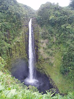
- Akaka FallsAkaka Falls State ParkAkaka Falls State Park is a state park on Hawaii Island, in the US state of Hawaii.The park is about north from Hilo, west of Honomū off the Hawaii Belt Road at the end of Hawaii Route 220, . It includes Akaka Falls, a tall waterfall. Akaka in the Hawaiian language means "A rent, split, chink,...
; the second tallest waterfall on the island. - Amy B. H. Greenwell Ethnobotanical GardenAmy B. H. Greenwell Ethnobotanical GardenThe Amy B. H. Greenwell Ethnobotanical Garden is a botanical garden near Captain Cook, Hawaii in the Kona District on the Big Island of Hawaii.-Description:The garden is operated by the Bernice P. Bishop Museum...
houses many endangered endemic plants. - East Hawaii Cultural CenterEast Hawaii Cultural CenterThe East Hawaii Cultural Center is a cultural center in Hilo, Hawaii, that has regular art exhibits and holds workshops and classes...
- Hawaii Tropical Botanical GardenHawaii Tropical Botanical GardenThe Hawaii Tropical Botanical Garden is a nonprofit botanical garden and nature preserve located off Route 19 at 27-717 Old Māmalahoa Highway , Pāpa'ikou, Hawaii , Hawaii. It is open daily; an admission fee is charged....
- Hawaii Volcanoes National ParkHawaii Volcanoes National ParkHawaii Volcanoes National Park, established in 1916, is a United States National Park located in the U.S. State of Hawaii on the island of Hawaii. It encompasses two active volcanoes: Kīlauea, one of the world's most active volcanoes, and Mauna Loa, the world's most massive volcano...
; comprising the active volcanoes Kīlauea and Mauna Loa - Hulihee PalaceHulihee PalaceThe Hulihee Palace is located in historic Kailua-Kona, Hawaii, on Alii Drive. The former vacation home of Hawaiian royalty, it was converted to a museum run by the Daughters of Hawaii, showcasing furniture and artifacts.-History:...
; a royal palaceKingdom of HawaiiThe Kingdom of Hawaii was established during the years 1795 to 1810 with the subjugation of the smaller independent chiefdoms of Oahu, Maui, Molokai, Lānai, Kauai and Niihau by the chiefdom of Hawaii into one unified government...
in Kailua-Kona - Imiloa Astronomy Center of Hawaii in Hilo
- Ka LaeKa LaeKa Lae , also known as South Point, is the southernmost point of the Big Island of Hawaii and of the 50 United States. The Ka Lae area is registered as a National Historic Landmark District under the name South Point Complex...
, the southernmost point in the United States - Laupahoehoe Train Museum
- Lyman House Memorial MuseumLyman House Memorial MuseumThe Lyman House Memorial Museum, also known as the Lyman Museum, is a Hilo, Hawaii-based natural history museum founded in 1931 in the Lyman family mission house, originally built in 1838.-The mission:...
in Hilo - Manuka State Wayside ParkManuka State Wayside ParkThe Manuka State Wayside Park is a state park of with an arboretum located approximately west of Naalehu, on the Mamalahoa Highway section of the Hawaii Belt Road, on the island of Hawaii, Hawaii, coordinates...
- Mauna Kea ObservatoryMauna Kea ObservatoryThe Observatories at Mauna Kea, , are an independent collection of astronomical research facilities located on the summit of Mauna Kea on the Big Island of Hawai'i, USA. The facilities are located in a special land use zone known as the "Astronomy Precinct," which is located in the Mauna Kea...
; Mauna Kea Observatories - Nani Mau GardensNani Mau GardensNani Mau Gardens are commercial botanical gardens located at 421 Makalika Street, Hilo, Hawaii on the island of Hawaii, coordinates . They are open daily, and an admission fee is charged. The gardens' name, Nani Mau, means "forever beautiful"...
- Onizuka Center for International AstronomyOnizuka Center for International AstronomyThe Onizuka Center for International Astronomy, also known as Hale Pōhaku, is a complex of support facilities for the telescopes and other instruments that comprise the Mauna Kea Observatory atop Mauna Kea, on Hawaii island.-History:...
- Onizuka Space Center; museum dedicated to the memory of ChallengerSpace Shuttle ChallengerSpace Shuttle Challenger was NASA's second Space Shuttle orbiter to be put into service, Columbia having been the first. The shuttle was built by Rockwell International's Space Transportation Systems Division in Downey, California...
astronaut Ellison OnizukaEllison Onizukawas a Japanese American astronaut from Kealakekua, Kona, Hawaii, who successfully flew into space with the Space Shuttle Discovery on STS-51-C, before losing his life to the destruction of the Space Shuttle Challenger, where he was serving as Mission Specialist for mission STS-51-L...
located in Kona's Keahole Airport - Pacific Tsunami MuseumPacific Tsunami MuseumPacific Tsunami Museum is a museum in Hilo, Hawaii dedicated to the history of the April 1, 1946 Pacific tsunami and the May 23, 1960 Chilean tsunami which devastated much of the east coast of the Big Island, especially Hilo. The museum also has a mission to educate people in general about...
overlooking Hilo Bay - Pana'ewa Rainforest ZooPana'ewa Rainforest ZooPanaewa Rainforest Zoo is located in Hilo on the Big Island of Hawaii. This small zoo is the only one in the United States located in a rainforest...
in Hilo - Pua Mau Place Arboretum and Botanical GardenPua Mau Place Arboretum and Botanical GardenPua Mau Place Arboretum and Botanical Garden is an early-stage, nonprofit arboretum and botanical garden located off Highway 270 at 10 Ala Kahua, Kawaihae, on the dry slopes of the Kohala Mountain Range on Hawaii , Hawaii. It is open daily with an admission fee.The garden was established in 1974...
- Puuhonua o Hōnaunau National Historical ParkPu'uhonua o Honaunau National Historical ParkPuuhonua o Hōnaunau National Historical Park is a United States National Historical Park located on the west coast of the island of Hawaii in the U.S. state of Hawaii. The historical park preserves the site where, up until the early 19th century, Hawaiians who broke a kapu could avoid certain...
- Rainbow Falls State ParkRainbow Falls (Hawaii)Rainbow Falls is a waterfall located in Hilo, Hawaii. It is tall and almost in diameter.At Rainbow Falls, the Wailuku River rushes into a large pool below. The gorge is blanketed by lush, dense tropical foliage and the turquoise colored pool is bordered by beautiful wild ginger...
- Sadie Seymour Botanical GardensSadie Seymour Botanical GardensThe Sadie Seymour Botanical Gardens are nonprofit botanical gardens located on the grounds of the Kona Outdoor Circle Educational Center at 76-6280 Kuakini Highway, Kailua-Kona, Hawaii island, Hawaii. Coordinates are . They are open daily; admission is free, but donations accepted.Sadie Seymour ...
- Umauma FallsUmauma FallsThe Umauma Falls are located on the Umauma River on the Big Island of Hawaii, approximately 16 miles north of Hilo.They are unique in Hawaii as being a series of three waterfalls in close proximity. They are easily viewed from an overlook located on private botanical garden property accessible for...
- University of Hawaii at Hilo Botanical GardensUniversity of Hawaii at Hilo Botanical GardensThe University of Hawaii at Hilo Botanical Gardens are botanical gardens on the University of Hawaii at Hilo campus, located at 200 West Kawili Street, Hilo, Hawaii on the island of Hawaii. They are open daily without charge....
- World Botanical GardensWorld Botanical GardensWorld Botanical Gardens and Waterfalls is a commercial botanical gardens with a large waterfall, located between Umauma and Hakalau, at the corner of Leopolino Road and Hawaii Belt Road, State Highway 19, 16 miles north of Hilo, Island of Hawaii, Hawaii. The gardens are open daily with an...
- Waipio ValleyWaipio valleyWaipio Valley is a valley located in the Hamakua District of the Big Island of Hawaii. "Waipio" means "curved water" in the Hawaiian language.It was the capital and permanent residence of many early Hawaiian alii up until the time of King Umi...
- Wao Kele o PunaWao Kele o PunaWao Kele O Puna is Hawaii's largest remaining lowland wet forest, about south of the city of Hilo, along the East Rift Zone of Kīlauea volcano on the Island of Hawaii. The name means the upland rainforest of Puna. Puna is one of 9 districts on the island...
Cities and towns
The island was traditionally divided into districts called moku. The names of the districts are (counter-clockwise, from the southeast): PunaPuna, Hawaii
Puna is one of the nine districts in Hawaii County, Big Island, Hawaii. The District of Puna is located on the easternmost portion of the island and shares borders to the north with the District of South Hilo and a border to the west with the District of Kaū...
, Hilo, Hāmākua, Kohala
Kohala, Hawaii
thumb|right|300px|The districts of the [[Hawaii |Big Island]]. From Northernmost, clockwise; Kohala , [[Hamakua|Hāmākua]], [[Hilo, Hawaii|Hilo]], [[Puna, Hawaii|Puna]], [[Kau, Hawaii|Kaū]], [[Kona District, Hawaii|Kona]]...
, Kona
Kona District, Hawaii
Kona is the name of a moku or district on the Big Island of Hawaii in the State of Hawaii. In the current system of administration of Hawaii County, the moku of Kona is divided into North Kona District and South Kona District . The term "Kona" is sometimes used to refer to its largest town,...
, and Kaū
Kau, Hawaii
thumb|right|300px|The districts of the [[Hawaii |Big Island]]. From Northernmost, clockwise; [[Kohala, Hawaii|Kohala]], [[Hamakua]], [[Hilo, Hawaii|Hilo]], [[Puna, Hawaii|Puna]], Kau , [[Kona District, Hawaii|Kona]]...
. The county government
Hawaii County, Hawaii
Hawaii County is a county located in the U.S. state of Hawaii in the Hawaiian Islands. It is coterminous with the Island of Hawaii, often called the "Big Island" to distinguish it from the state as a whole. As of the 2010 Census the population was 185,079. The county seat is Hilo. There are no...
subdivides some of these to form elective districts of the county council. There are no incorporated municipalities on the island. Some of the named towns include:
|
Keauhou, Hawaii Keauhou is an unincorporated community on the island of Hawaii in Hawaii County, Hawaii, United States. Its elevation is 13 feet . Because the community has borne multiple names, the Board on Geographic Names officially designated it "Keauhou" in 1914... |
Milolii, Hawaii Milolii is an unincorporated community on the island of Hawaii in the U.S. state of Hawaii. Situated at the bottom of a 1926 lava flow 33 miles south of Kailua-Kona, Milolii is purported to be "the last Hawaiian fishing village" according to a wooden sign in their community center.Without... Ninole, Hawaii Nīnole is the name of two unincorporated communities on the island of Hawaii in Hawaii County, Hawaii, United States. In the Hawaiian language Nīnole means "bending"... 'O'okala, Hawaii Ōōkala is an unincorporated community on the island of Hawaii in Hawaii County, Hawaii, United States. It lies along Hawaii Route 19 north of Hilo, the county seat of Hawaii County. Its elevation is 371 feet , and it is located at... Papa'aloa, Hawaii Papaaloa is an unincorporated community on the island of Hawaii in Hawaii County, Hawaii, United States. It lies along Hawaii Route 19 north of Hilo, the county seat of Hawaii County... Wainaku, Hawaii Wainaku is a census-designated place in Hawaii County, Hawaii, United States. The population was 1,227 at the 2000 census.-Geography:Wainaku is located at .... |
Colleges and universities
- University of Hawaii at HiloUniversity of Hawaii at HiloThe University of Hawaii at Hilo, UHH, or UH Hilo is one of the ten branches of the University of Hawaii system anchored by the University of Hawaii at Mānoa in Honolulu, Hawaii...
- University of the NationsUniversity of the NationsThe University of the Nations is a global Christian university with branch campuses in 600 locations in 142 countries, providing coursework in over 100 languages around the world. Its largest locations are in Kona, Hawaii , Jeju, South Korea, and Perth, Australia...
- Hawaii Community CollegeHawaii Community CollegeHawaii Community College is a public, co-educational commuter college in Hilo, Hawaii on the Island of Hawaii. It is one of ten branches of the University of Hawaii system anchored by the University of Hawaii at Mānoa in Honolulu and is accredited by the Western Association of Schools and...
Roads
Two roads connect the two major cities, Hilo on the east coast and Kailua-Kona on the west coast of the island:- State highways 19 & 190, the northern route via WaimeaWaimea-Places:United States*Waimea, Hawaii County, Hawaii *Waimea, Kauai County, Hawaii*Waimea Bay, Hawaii on Oahu*Waimea Canyon State Park on Kauai*Waimea Ditch on Kauai*Waimea River on Kauai*Waimea Valley on OahuNew Zealand...
- State highway 11, the southern route via Hawaii Volcanoes National ParkHawaii Volcanoes National ParkHawaii Volcanoes National Park, established in 1916, is a United States National Park located in the U.S. State of Hawaii on the island of Hawaii. It encompasses two active volcanoes: Kīlauea, one of the world's most active volcanoes, and Mauna Loa, the world's most massive volcano...
There are also State highways 270 (Kawaihae
Kawaihae
Kawaihae is an unincorporated community on the west side of the island of Hawaii in the U.S. state of Hawaii, north of Kailua-Kona. Its harbor includes a fuel depot, shipping terminal and military landing site. Outside of the man-made breakwall of the harbor is a popular surf spot and the Pua...
- Hawi) and 180 (the "Kona coffee
Kona coffee
Kona coffee is the market name for coffee cultivated on the slopes of Hualalai and Mauna Loa in the North and South Kona Districts of the Big Island of Hawaii. It is one of the most expensive coffees in the world. Only coffee from the Kona Districts can be described as "Kona"...
road", from Honalo to State highway 190), Saddle Road (Hilo to Waimea, passing between Mauna Loa
Mauna Loa
Mauna Loa is one of five volcanoes that form the Island of Hawaii in the U.S. state of Hawaii in the Pacific Ocean, and the largest on Earth in terms of volume and area covered. It is an active shield volcano, with a volume estimated at approximately , although its peak is about lower than that...
and Mauna Kea
Mauna Kea
Mauna Kea is a volcano on the island of Hawaii. Standing above sea level, its peak is the highest point in the state of Hawaii. However, much of the mountain is under water; when measured from its oceanic base, Mauna Kea is over tall—significantly taller than Mount Everest...
), South Point Road (Highway 11 to South Point
Ka Lae
Ka Lae , also known as South Point, is the southernmost point of the Big Island of Hawaii and of the 50 United States. The Ka Lae area is registered as a National Historic Landmark District under the name South Point Complex...
), etc.
Rental car offices are at the international airports. Taxi
Taxicab
A taxicab, also taxi or cab, is a type of vehicle for hire with a driver, used by a single passenger or small group of passengers, often for a non-shared ride. A taxicab conveys passengers between locations of their choice...
service is also available. Island-wide zero-fare public transport
Zero-fare public transport
Free public transport, also often called free public transit or zero-fare public transport, is a single or network of transport services funded in full by means other than collecting a full fare from passengers. It may be funded by national, regional or local government through taxation or by...
is provided by the "Hele-On Bus".
Airports
Two commercial airports serve Hawaii Island:- Hilo International AirportHilo International AirportHilo International Airport , formerly General Lyman Field, is owned and operated by the Hawaii state Department of Transportation. Located in Hilo, Hawaii County, the airport encompasses and is one of two major airports on Hawaii Island and one of five major airports in the state...
- Kona International AirportKona International AirportKona International Airport at Keāhole is an airport on the Island of Hawaii, in Kalaoa CDP, Hawaii County, Hawaii, United States. The airport serves leeward, or Western Hawaii island, including the town of Kailua-Kona and the major resorts of the North Kona and South Kohala districts.- History...
There is also:
- Waimea-Kohala AirportWaimea-Kohala AirportWaimea-Kohala Airport is an airport located one nautical mile southwest of Kamuela , an unincorporated town in Hawai‘i County, Hawai‘i, United States....
(MUE) - Upolu AirportUpolu AirportUpolu Airport is a regional airport of the State of Hawai'i in Hawai'i County. Located on the northern tip of the Big Island, Upolu Airport is northwest of the unincorporated town of Hawi.- Facilities and aircraft :...
(UPP)
Seaports
Major commercial ports are Hilo on the East side and Kawaihae on the West side of the island. Cruise ships often stop at Kailua-Kona.See also
- National Register of Historic Places listings on the island of HawaiiNational Register of Historic Places listings on the island of HawaiiThis is a list of properties and districts on the island of Hawaii in the U.S. state of Hawaii that are listed on the National Register of Historic Places. The island is coterminous with Hawaii County, the state's only county that covers exactly one island...
External links
- Hawaii State overview
- The West Hawaii Today
- Hawaii Tribune-Herald - East Hawaii Newspaper
- Big Island Video News - video news for Hawaii island
- Hawaii Weather Today - Glenn's daily Weather Narrative
- Pacific Disaster Center - The Source for Daily Pacific Disaster News
- http://hvo.wr.usgs.gov/earthquakes/destruct/1975Nov29/ - Hilina Slump information from Hawai'i Volcanoes Observatory