
Line Islands
Encyclopedia

The Line Islands, Teraina Islands or Equatorial Islands, is a chain of eleven atoll
Atoll
An atoll is a coral island that encircles a lagoon partially or completely.- Usage :The word atoll comes from the Dhivehi word atholhu OED...
s and low coral island
Island
An island or isle is any piece of sub-continental land that is surrounded by water. Very small islands such as emergent land features on atolls can be called islets, cays or keys. An island in a river or lake may be called an eyot , or holm...
s in the central Pacific Ocean
Pacific Ocean
The Pacific Ocean is the largest of the Earth's oceanic divisions. It extends from the Arctic in the north to the Southern Ocean in the south, bounded by Asia and Australia in the west, and the Americas in the east.At 165.2 million square kilometres in area, this largest division of the World...
, south of the Hawaiian Islands
Hawaiian Islands
The Hawaiian Islands are an archipelago of eight major islands, several atolls, numerous smaller islets, and undersea seamounts in the North Pacific Ocean, extending some 1,500 miles from the island of Hawaii in the south to northernmost Kure Atoll...
, that stretches for 2,350 km in a northwest-southeast direction, making it one of the longest islands chains of the world. Eight of the islands form part of Kiribati
Kiribati
Kiribati , officially the Republic of Kiribati, is an island nation located in the central tropical Pacific Ocean. The permanent population exceeds just over 100,000 , and is composed of 32 atolls and one raised coral island, dispersed over 3.5 million square kilometres, straddling the...
, while the remaining three are United States
United States
The United States of America is a federal constitutional republic comprising fifty states and a federal district...
territories grouped with the United States Minor Outlying Islands
United States Minor Outlying Islands
The United States Minor Outlying Islands, a statistical designation defined by the International Organization for Standardization's ISO 3166-1 code, consists of nine United States insular areas in the Pacific Ocean and Caribbean Sea: Baker Island, Howland Island, Jarvis Island, Johnston Atoll,...
.
Those that are part of Kiribati are in the world's farthest forward time zone
Time zone
A time zone is a region on Earth that has a uniform standard time for legal, commercial, and social purposes. In order for the same clock time to always correspond to the same portion of the day as the Earth rotates , different places on the Earth need to have different clock times...
, UTC
Coordinated Universal Time
Coordinated Universal Time is the primary time standard by which the world regulates clocks and time. It is one of several closely related successors to Greenwich Mean Time. Computer servers, online services and other entities that rely on having a universally accepted time use UTC for that purpose...
+14
UTC+14
UTC+14 is an identifier for a +14 hour time offset from UTC. This is the highest time zone, meaning that areas in this zone are the first to see a new day, and therefore the first to celebrate a new year....
. The time of day is the same as in Hawaii
Hawaii
Hawaii is the newest of the 50 U.S. states , and is the only U.S. state made up entirely of islands. It is the northernmost island group in Polynesia, occupying most of an archipelago in the central Pacific Ocean, southwest of the continental United States, southeast of Japan, and northeast of...
, but the date is one day ahead. The time is 26 hours ahead of some other islands in Oceania
Oceania
Oceania is a region centered on the islands of the tropical Pacific Ocean. Conceptions of what constitutes Oceania range from the coral atolls and volcanic islands of the South Pacific to the entire insular region between Asia and the Americas, including Australasia and the Malay Archipelago...
like Baker Island
Baker Island
Baker Island is an uninhabited atoll located just north of the equator in the central Pacific Ocean about southwest of Honolulu. The island lies almost halfway between Hawaii and Australia, and is a possession of the United States. Its nearest neighbor is Howland Island, to the north.Located at...
which have UTC
Coordinated Universal Time
Coordinated Universal Time is the primary time standard by which the world regulates clocks and time. It is one of several closely related successors to Greenwich Mean Time. Computer servers, online services and other entities that rely on having a universally accepted time use UTC for that purpose...
-12
UTC-12
UTC−12:00 is an identifier for a time offset from UTC of −12 hours.-As standard time :* Baker Island and Howland Island are assigned to this time zone....
.
The United States previously claimed all the Line Islands under the Guano Islands Act
Guano Islands Act
The Guano Islands Act is federal legislation passed by the U.S. Congress, on August 18, 1856. It enables citizens of the U.S. to take possession of islands containing guano deposits. The islands can be located anywhere, so long as they are not occupied and not within the jurisdiction of other...
. This claim was relinquished under the Treaty of Tarawa
Treaty of Tarawa
On September 20, 1979, representatives of the newly independent Republic of Kiribati and of the United States met in Tarawa to sign a treaty of friendship between the two nations, known as the Treaty of Tarawa. In this treaty, the U.S. acknowledged Kiribati sovereignty over fourteen islands...
, which recognised Kiribati's sovereignty over the majority of the chain.
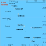
The group is geographically divided into three subgroups; The Northern, Central, and Southern Line Islands. The Central Line Islands are sometimes grouped with the Southern Line Islands. The table below lists the islands from North to South.
| Atoll Atoll An atoll is a coral island that encircles a lagoon partially or completely.- Usage :The word atoll comes from the Dhivehi word atholhu OED... /Island Island An island or isle is any piece of sub-continental land that is surrounded by water. Very small islands such as emergent land features on atolls can be called islets, cays or keys. An island in a river or lake may be called an eyot , or holm... /Reef Reef In nautical terminology, a reef is a rock, sandbar, or other feature lying beneath the surface of the water .... | Island Areakm² | Lagoon Lagoon A lagoon is a body of shallow sea water or brackish water separated from the sea by some form of barrier. The EU's habitat directive defines lagoons as "expanses of shallow coastal salt water, of varying salinity or water volume, wholly or partially separated from the sea by sand banks or shingle,... km² | Population | Coordinates | Status |
|---|---|---|---|---|---|
Northern Line Islands (Fanning's Group) |
|||||
| Kingman Reef Kingman Reef Kingman Reef is a largely submerged, uninhabited triangular shaped reef, east-west and north-south, located in the North Pacific Ocean, roughly half way between the Hawaiian Islands and American Samoa at... |
0.03 | 60 | 0 | 6°24′N 162°24′W | U.S. United States The United States of America is a federal constitutional republic comprising fifty states and a federal district... unincorporated territory |
| Palmyra Atoll Palmyra Atoll Palmyra Atoll is an essentially unoccupied equatorial Northern Pacific atoll administered as an unorganized incorporated territory by the United States federal government... |
6.56 | 15 | ~4 | 5°52′N 162°6′W | U.S. United States The United States of America is a federal constitutional republic comprising fifty states and a federal district... incorporated territory Incorporated territory Territories of the United States are one of the four types of political division of the United States, overseen directly by the federal government of the United States and not any part of a U.S. state. These territories were created to govern newly acquired land while the borders of the United... |
| Teraina Teraina Teraina, also known as Washington Island is a coral atoll in the central Pacific Ocean and part of the Northern Line Islands which belongs to Kiribati. Obsolete names of Teraina are Prospect Island and New York Island. The island is located approximately 4.71° North latitude and 160.76° West... (Washington Island) |
14.2 | 2* | 1,155 | 4°43′N 160°24′W | part of Kiribati Kiribati Kiribati , officially the Republic of Kiribati, is an island nation located in the central tropical Pacific Ocean. The permanent population exceeds just over 100,000 , and is composed of 32 atolls and one raised coral island, dispersed over 3.5 million square kilometres, straddling the... |
| Tabuaeran Tabuaeran Tabuaeran, also known as Fanning Island or Fanning Atoll is one of the Line Islands of the central Pacific Ocean, and part of Kiribati. It is an atoll located at... (Fanning Island) |
33.7 | 110 | 2,539 | 3°52′N 159°22′W | part of Kiribati Kiribati Kiribati , officially the Republic of Kiribati, is an island nation located in the central tropical Pacific Ocean. The permanent population exceeds just over 100,000 , and is composed of 32 atolls and one raised coral island, dispersed over 3.5 million square kilometres, straddling the... |
| Kiritimati Kiritimati Kiritimati or Christmas Island is a Pacific Ocean raised coral atoll in the northern Line Islands, and part of the Republic of Kiribati.... (Christmas Island) |
c.322 | c.320 | 5,115 | 1°53′N 157°24′W | part of Kiribati Kiribati Kiribati , officially the Republic of Kiribati, is an island nation located in the central tropical Pacific Ocean. The permanent population exceeds just over 100,000 , and is composed of 32 atolls and one raised coral island, dispersed over 3.5 million square kilometres, straddling the... |
Central Line Islands |
|||||
| Jarvis Island Jarvis Island Jarvis Island is an uninhabited 4.5 square kilometer coral island located in the South Pacific Ocean at , about halfway between Hawaii and the Cook Islands... |
4.45 | - | 0 | 0°22′S 160°03′W | U.S. United States The United States of America is a federal constitutional republic comprising fifty states and a federal district... unincorporated territory |
| Malden Island Malden Island Malden Island, sometimes called Independence Island in the nineteenth century, is a low, arid, uninhabited island in the central Pacific Ocean, about in area... |
39.3 | 13* | 0 | 4°01′S 154°59′W | part of Kiribati Kiribati Kiribati , officially the Republic of Kiribati, is an island nation located in the central tropical Pacific Ocean. The permanent population exceeds just over 100,000 , and is composed of 32 atolls and one raised coral island, dispersed over 3.5 million square kilometres, straddling the... |
| Filippo Reef Filippo Reef Filippo Reef is a reef that is asserted to be located in the Pacific Ocean at , 450 km east of Starbuck Island in the Line Islands, which was reported by the master of the Italian barque Filippo as having been seen on 28 June 1886... |
- | 1.5 | 0 | 5°30′S 151°50′W | outside EEZ |
| Starbuck Island Starbuck Island Starbuck Island is an uninhabited coral atoll in the central Pacific, and is part of the Central Line Islands of Kiribati... |
21 | 25 | 0 | 5°37′S 155°56′W | part of Kiribati Kiribati Kiribati , officially the Republic of Kiribati, is an island nation located in the central tropical Pacific Ocean. The permanent population exceeds just over 100,000 , and is composed of 32 atolls and one raised coral island, dispersed over 3.5 million square kilometres, straddling the... |
Southern Line Islands |
|||||
| Caroline Island Caroline Island Caroline Island or Caroline Atoll , is the easternmost of the uninhabited coral atolls which comprise the southern Line Islands in the central Pacific Ocean.... |
3.76 | 6.3 | 0 | 9°57′S 150°13′W | part of Kiribati Kiribati Kiribati , officially the Republic of Kiribati, is an island nation located in the central tropical Pacific Ocean. The permanent population exceeds just over 100,000 , and is composed of 32 atolls and one raised coral island, dispersed over 3.5 million square kilometres, straddling the... |
| Vostok Island Vostok Island Vostok Island also known as Staver Island, is an uninhabited coral island in the central Pacific Ocean, part of the Line Islands belonging to Kiribati... |
0.24 | - | 0 | 10°06′S 152°25′W | part of Kiribati Kiribati Kiribati , officially the Republic of Kiribati, is an island nation located in the central tropical Pacific Ocean. The permanent population exceeds just over 100,000 , and is composed of 32 atolls and one raised coral island, dispersed over 3.5 million square kilometres, straddling the... |
| Flint Island Flint Island Flint Island is an uninhabited coral atoll in the central Pacific Ocean, part of the Southern Line Islands under the jurisdiction of Kiribati.-Geography:... |
3 | - | 0 | 11°26′S 151°48′W | part of Kiribati Kiribati Kiribati , officially the Republic of Kiribati, is an island nation located in the central tropical Pacific Ocean. The permanent population exceeds just over 100,000 , and is composed of 32 atolls and one raised coral island, dispersed over 3.5 million square kilometres, straddling the... |
| Line Islands | 514.74 | 542 | 8,809 | ||
* The lagoon areas marked with an asterisk are contained within the island areas of the previous column because they are, unlike in the case of a typical atoll, inland waters completely sealed off from the sea.
Only three islands are inhabited, with a total population of 8,809 (census
Census
A census is the procedure of systematically acquiring and recording information about the members of a given population. It is a regularly occurring and official count of a particular population. The term is used mostly in connection with national population and housing censuses; other common...
of 2005), of which 5,115 are on Kiritimati
Kiritimati
Kiritimati or Christmas Island is a Pacific Ocean raised coral atoll in the northern Line Islands, and part of the Republic of Kiribati....
, 2,539 on Tabuaeran
Tabuaeran
Tabuaeran, also known as Fanning Island or Fanning Atoll is one of the Line Islands of the central Pacific Ocean, and part of Kiribati. It is an atoll located at...
, and 1,155 on Teraina
Teraina
Teraina, also known as Washington Island is a coral atoll in the central Pacific Ocean and part of the Northern Line Islands which belongs to Kiribati. Obsolete names of Teraina are Prospect Island and New York Island. The island is located approximately 4.71° North latitude and 160.76° West...
. The total population of these three atolls in 1900 was about 300.
Kiritimati is the largest atoll
Atoll
An atoll is a coral island that encircles a lagoon partially or completely.- Usage :The word atoll comes from the Dhivehi word atholhu OED...
in the world in terms of land area. The islands were annexed by Britain
United Kingdom
The United Kingdom of Great Britain and Northern IrelandIn the United Kingdom and Dependencies, other languages have been officially recognised as legitimate autochthonous languages under the European Charter for Regional or Minority Languages...
in 1888 with a view to laying the Pacific cable
All Red Line
The All Red Line was an informal name for the system of electrical telegraphs that linked much of the British Empire.It was inaugurated on 31 October 1902. It had this name because on many political maps, British Empire territory was coloured red ....
with Tabuaeran (then Fanning Island) as a relay station. Said cable functioned between 1902 and 1963 except for a short period in 1914.
Copra
Copra
Copra is the dried meat, or kernel, of the coconut. Coconut oil extracted from it has made copra an important agricultural commodity for many coconut-producing countries. It also yields coconut cake which is mainly used as feed for livestock.-Production:...
and "Petfish" are the main export products (with seaweed).