
Kilauea
Encyclopedia
Kīlauea is a volcano
in the Hawaiian Islands
, and one of five shield volcano
es that together form the island of Hawaii
. Kīlauea means "spewing" or "much spreading" in the Hawaiian language
, referring to its frequent outpouring of lava
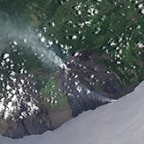
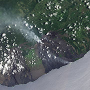
. The Puu Ōō cone has been continuously erupting in the eastern rift-zone since 1983, making it the longest rift-zone eruption of the last 200 years. Thirty-five eruptions have taken place since 1952, not including the current episode. Lava less than 1000 years old covers 90% of Kīlauea, and the volume of erupted material is large enough to pave a road around the world three times.
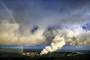
Kīlauea is one of the most active volcanoes on the planet and an invaluable resource for volcanologists
who are able to study it up close due to its exclusively non-violent effusive
activity. Since 2008, rising emissions of sulphur dioxide from the Halemaumau crater
at Kīlauea's summit have led to increased levels of volcanic smog
and air quality concerns. Located within Hawaii Volcanoes National Park
, Kīlauea is visited by millions of tourists each year, making it the most visited attraction in Hawaii and the most visited volcano in the world. Despite its relative safety for researchers and visitors alike, Kīlauea is regarded by the USGS as the most dangerous volcano in the U.S. In 2010 and early 2011, lava destroyed several houses in the Kalapana area. According to the United States Geological Survey, the Volcanic-Alert Level for Kīlauea as of June 2011 is "Watch". Since April 2011, Kīlauea surface volcanic activity remains confined inside or near two vents: one in the summit caldera, inside Halemaumau, and the other on the east rift zone at Pu'u 'Ō'ō.
In the Hawaiian religion
, Kīlauea is home to Pele, the goddess of volcanoes.
Kīlauea lies against the southeast flank of the much larger Mauna Loa volcano. Mauna Loa's massive size and elevation (13,677 feet or 4,169 m) is a stark contrast to Kīlauea, which rises only 4,091 feet (1,247 m) above sea level, and thus from the summit caldera appears as a broad shelf of uplands well beneath the long profile of occasionally snow-capped Mauna Loa, 15 miles (24.1 km) distant.
Kīlauea is a very low, flat shield volcano
— vastly different in profile from the high, sharply sloping peaks of stratovolcano
es like Mt. Fuji, Mount Hood
, and Mount St. Helens
.
flank of Mauna Loa. The crossing onto lava flows issued from Kīlauea is not until about 1 miles (1.6 km) west of Glenwood, 18 miles (29 km) from Hilo. The verdant, forested Mauna Loa flows are several thousand years old, whereas the lightly vegetated Kīlauea flows are only 350 to 500 years old.
 Driving south from Kailua-Kona on the west coast of Hawaii, Kīlauea is 98 miles (157.7 km) distant along the Hawaii Belt Road, which passes through Kaū, the southernmost district of the island. After passing around the southern end of Mauna Loa's lengthy lower flank, the highway then turns northeast towards Kīlauea. The route through Kaū is different from the verdant forests seen when coming from Hilo: The route from the south approaches Kīlauea through the Kaū Desert, on the volcano's leeward slope. Kīlauea's height of 4000 feet (1,219.2 m) is sufficient to force most of the moisture out of the impinging northeasterly trade winds, leaving much of Kaū in the rain shadow
of the "low" mountain, creating a desert effect. The desert effect is also produced by the acid rain resulting from sulfur dioxide emitted by the volcano. This area is also the very active southwest rift zone
of Kīlauea, a prolific ash
producer. Winds redistribute the ash, causing dust storm
s and dune
s barren of most vegetation.
As from the Hilo side, the long gradual climb from near sea level to the summit is actually all on the flank of Mauna Loa. Not until the Sulfur Bank scarp
(the northwestern edge of Kīlauea Caldera), near the intersection of Crater Rim Drive in Hawaii Volcanoes National Park, does the road cross over onto Kīlauea. From near Punaluu at the coast to the caldera at the summit, the highway parallels the line of contact between the two volcanoes — always less than 1 miles (1.6 km) southeast of that line.
encompasses a portion of Kīlauea, and the Kīlauea Visitor Center is located near the margin of the summit caldera
, overlooking a large pit crater
called Halema`uma`u. The roughly circular caldera measures 3x5 km (or 6x6 km, including the outermost ring faults). The Visitor Center features exhibits about volcano, the plants and animals in the park, and the island's cultural history.
, an eruption killed a party of warriors and their families. These soldiers were part of the army controlled by Keōua Kuahuula
, the last chief on the island to resist Kamehameha I
. In 1825, Admiral Lord Byron
, cousin of the famous poet, visited the volcano. His campsite, still known as "Byron's Ledge" is located at coordinates 19°24′54"N 155°15′23"W.
While Kīlauea is currently known for its largely non-explosive eruptions, it has had large explosive eruptions in the past. The most recent of such explosive eruptions occurred in 1924, when magma interacted with groundwater as the long-standing lava lake
in Halemaumau Crater drained. Eruption column
s are inferred to have risen at least as high as 9 km (5.6 mi) and possibly up to 15–20 km (9–12 miles)—much higher than the cruising altitude of airliners. One of the most spectacular episodes of Kīlauea lava fountain
ing occurred in 1959 during the Kīlauea Iki
eruption. Lava sprayed nearly 580 meters (1900 ft) high. Eruptions from Kīlauea also are known for creating vog
(volcanic smog), which usually affects parts of Hawaii
, but can extend over many areas of the Hawaiian Islands
whenever winds come out of the south or southeast.
 Eruptions at Kīlauea occur primarily either from the summit caldera or along either of the East and Southwest rift zone
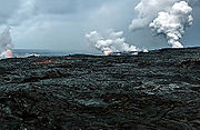
s that extend from the caldera and run approximately parallel to the coastline. In recent decades, eruptions have been continuous, with many of the lava flows reaching to the Pacific Ocean
shore. About 90% of the surface of Kīlauea is lava flows less than 1,100 years old; 70% of the surface is younger than 600 years. There were 45 eruptions of Kīlauea in the 20th century.
in recorded history. The eruption created a new vent, covered massive amounts of land with lava
, and added new land to the island. The eruption first started as a fissure between two pit crater
s, Āloi and Alae, where the Mauna Ulu shield would eventually form. Both pāhoehoe and aā lava erupted from the volcano. Early on, fountains of lava burst out as much as 540 meters (1772 ft) high. In early 1973, an earthquake occurred that caused Kīlauea to stop erupting near the original Mauna Ulu site and instead erupt near the craters Pauahi
and Hiiaka. However, the eruption site soon returned to normal.
In the early morning of March 19, 2008, Halemaumau experienced its first explosive event since 1924 and the first eruption in the Kīlauea caldera since September 1982. A steam vent that had recently opened near the overlook area exploded, generating a magnitude 3.7 earthquake, and scattering rocks over a 75 acres (303,514.5 m²) area. A small amount of ash was also reported at a nearby community. The explosion debris covered part of Crater Rim Drive and damaged Halemaumau overlook. The explosion did not release any lava, which suggests to scientists that it was driven by hydrothermal or gas sources.
This explosion event followed increased sulfur dioxide gas levels from the Halemaumau crater. The dangerous increase of sulfur dioxide gas has prompted closures of Crater Rim Drive between Kīlauea Military Camp south/southeast to Chain of Craters Road
, Crater Rim Trail from Kīlauea Military Camp southsoutheast to Chain of Craters Road, and all trails leading to Halemaumau crater, including those from Byron Ledge, Iliahi (Sandalwood) Trail, and Kaū Desert Trail.
Early in the morning of March 24, 2008, the white gas ejection changed to brown-gray ash, and lava particles were thrown from the vent, forming Pele's hair
, Pele's tears
, and 4 inches (101.6 mm) lava spatters around the vent. This is the first time fresh lava has been erupted in the crater since 1982.
 The current Kīlauea eruption began on January 3, 1983, along the East rift zone at the Pu'u 'Ō'ō vent, where vigorous fountaining built up Puu Ōō cone and sent lava flows downslope. In 1986, activity shifted downrift to a new vent, named Kupaianaha ("mysterious" or "astonishing" in Hawaiian), where it took on a more effusive character. Kupaianaha built into a low, broad shield rather than a cone, and tube
-fed lava flows extended 11 to 12 km to the sea. In 1992, the eruption moved back to Puu Ōō, but continued in the same manner, covering nearly all of the 1983-86 lava flows and large areas of coastline. This eruption has covered over 117 km² of land on the southern flank of Kīlauea and has built out into the sea 2 km² (230 hectares) of new land. Since 1983 more than 2.7 km³ of lava has been erupted, making the 1983-to-present eruption the largest historically known for Kīlauea. 189 structures have been destroyed.
At 1:42 p.m. on March 5, 2011, Puu Ōō began to rapidly deflate followed 18 minutes later by Kīlauea's summit. As magma began to drain from both, harmonic tremors substantially increased along the east rift zone. As the magma continued to drain away, Puu Ōō suffered several collapses as its crater floor continued to subside. At 5:15 p.m. a new eruption was observed to have begun from a fissure located between Napau Crater and Puu Ōō. At the same time, the lava stream to the coastal flows turned sluggish, and by March 7, all activity at Kalapana had stopped.
The new eruption was given the name of the 'Kamoamoa Fissure Eruption' by volcanologists, and a National Park ranger stated that the volume of lava being produced by the vents was estimated to be five times that of the previous eruption on the East Rift, with the new vents generating about 2.5 million cubic meters of molten rock a day. About 120 acres were said to have been covered with lava by March 8, all within the National Park in a remote area.
. The 1990 lava flows were notable for their destruction; the towns of Kalapana and Kaimū were totally destroyed, as were Kaimū Bay, Kalapana black sand beach, and a large section of Route 130, which now abruptly dead-ends at the lava flow.
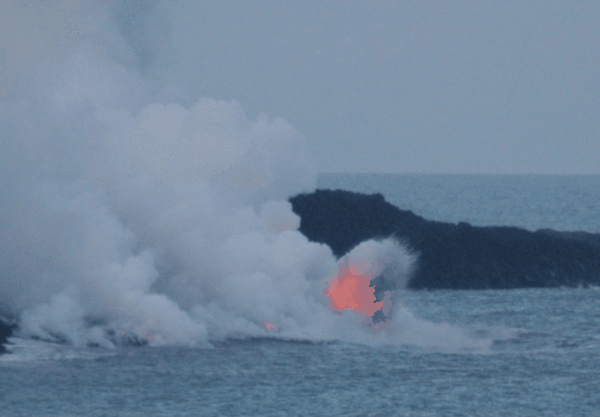
Lava from Kīlauea destroyed three abandoned houses in the week of February 25, 2008, in a nearly deserted neighborhood. On the night of March 5, 2008, lava from the flows again reached the ocean off the Puna
coast, creating a spectacular show of light and color. Hawaii County Civil Defense officials set up a viewing center nearby for the public to observe the phenomenon; however, the site was covered with lava July 17, 2010, by a flow that was heading east towards houses near the Kalapana Gardens subdivision built on the 1990 lava flows, with one home at that time being evacuated as a precaution. The home was destroyed by lava July 25; it was reportedly the first occupied home to be claimed by the volcano in a decade, although 17 abandoned "structures" in the Royal Gardens subdivision had been overrun by lava in 2008-09. Lava also reached the ocean and again entered the water.
On November 27, 2010, another home near Kalapana Gardens was destroyed as a result of a slow-moving Kilauea lava flow. The house had already been evacuated. The relocated public viewing area was closed as a precaution. Other lava flows were reported in the region but none directly threatened the remaining homes in the subdivision at that time. Lava continued to flow into the water at the Puhi o Kalaikini ocean entry.
January 17, 2011, saw another Kalapana area home taken by the lava. The homeowner, who had worked for years to replant the three-acre lot that the home was built on, was quoted as saying "We'll probably be back to start over."
 For Native Hawaiians, Kīlauea is considered the "body" of Pele, the volcano goddess of ancient Hawaiian legend. Several lava formations are named after her, including Pele's tears
(small droplets of lava that cool in the air and retain their teardrop shapes) and Pele's hair
(thin, brittle strands of volcanic glass that often form during the explosions that accompany a lava flow as it enters the ocean).
In Hawaiian mythology
, Kīlauea is where most of the conflict between Pele and the rain god Kamapuaa
took place. Halemaumau, "House of the amaumau fern", derives its name from the final struggle between the two gods: since it was the favorite residence of Pele, Kamapuaa, hard-pressed by Pele's ability to make lava spout from the ground at will, covered it with the fronds of the fern. Choking from the smoke which could not escape anymore, Pele emerged. Realizing that each could threaten the other with destruction, the gods had to call their fight a draw and divided the island between them: Kamapuaa got the windward northeastern side, and Pele got the drier Kona (or leeward) side. The rusty singed appearance of the young fronds of the amaumau was said to be a product of the legendary struggle.
Volcano
2. Bedrock3. Conduit 4. Base5. Sill6. Dike7. Layers of ash emitted by the volcano8. Flank| 9. Layers of lava emitted by the volcano10. Throat11. Parasitic cone12. Lava flow13. Vent14. Crater15...
in the Hawaiian Islands
Hawaiian Islands
The Hawaiian Islands are an archipelago of eight major islands, several atolls, numerous smaller islets, and undersea seamounts in the North Pacific Ocean, extending some 1,500 miles from the island of Hawaii in the south to northernmost Kure Atoll...
, and one of five shield volcano
Shield volcano
A shield volcano is a type of volcano usually built almost entirely of fluid lava flows. They are named for their large size and low profile, resembling a warrior's shield. This is caused by the highly fluid lava they erupt, which travels farther than lava erupted from more explosive volcanoes...
es that together form the island of Hawaii
Hawaii (island)
The Island of Hawaii, also called the Big Island or Hawaii Island , is a volcanic island in the North Pacific Ocean...
. Kīlauea means "spewing" or "much spreading" in the Hawaiian language
Hawaiian language
The Hawaiian language is a Polynesian language that takes its name from Hawaii, the largest island in the tropical North Pacific archipelago where it developed. Hawaiian, along with English, is an official language of the state of Hawaii...
, referring to its frequent outpouring of lava
Lava
Lava refers both to molten rock expelled by a volcano during an eruption and the resulting rock after solidification and cooling. This molten rock is formed in the interior of some planets, including Earth, and some of their satellites. When first erupted from a volcanic vent, lava is a liquid at...
. The Puu Ōō cone has been continuously erupting in the eastern rift-zone since 1983, making it the longest rift-zone eruption of the last 200 years. Thirty-five eruptions have taken place since 1952, not including the current episode. Lava less than 1000 years old covers 90% of Kīlauea, and the volume of erupted material is large enough to pave a road around the world three times.
Kīlauea is one of the most active volcanoes on the planet and an invaluable resource for volcanologists
Volcanology
Volcanology is the study of volcanoes, lava, magma, and related geological, geophysical and geochemical phenomena. The term volcanology is derived from the Latin word vulcan. Vulcan was the ancient Roman god of fire....
who are able to study it up close due to its exclusively non-violent effusive
Effusive eruption
An effusive eruption is a volcanic eruption characterized by the outpouring of lava onto the ground...
activity. Since 2008, rising emissions of sulphur dioxide from the Halemaumau crater
Halemaumau Crater
Halemaumau crater is a pit crater located within the much larger summit caldera of Kīlauea in Hawaii Volcanoes National Park. The roughly circular crater floor is x and is below the floor of Kīlauea caldera, located at coordinates . Halemaumau is home to Pele, Goddess of Hawaiian Volcanoes,...
at Kīlauea's summit have led to increased levels of volcanic smog
Vog
Vog is a form of air pollution that results when sulfur dioxide and other gases and particles emitted by an erupting volcano react with oxygen and moisture in the presence of sunlight. The word is a portmanteau of the words "volcanic" and "smog"...
and air quality concerns. Located within Hawaii Volcanoes National Park
Hawaii Volcanoes National Park
Hawaii Volcanoes National Park, established in 1916, is a United States National Park located in the U.S. State of Hawaii on the island of Hawaii. It encompasses two active volcanoes: Kīlauea, one of the world's most active volcanoes, and Mauna Loa, the world's most massive volcano...
, Kīlauea is visited by millions of tourists each year, making it the most visited attraction in Hawaii and the most visited volcano in the world. Despite its relative safety for researchers and visitors alike, Kīlauea is regarded by the USGS as the most dangerous volcano in the U.S. In 2010 and early 2011, lava destroyed several houses in the Kalapana area. According to the United States Geological Survey, the Volcanic-Alert Level for Kīlauea as of June 2011 is "Watch". Since April 2011, Kīlauea surface volcanic activity remains confined inside or near two vents: one in the summit caldera, inside Halemaumau, and the other on the east rift zone at Pu'u 'Ō'ō.
In the Hawaiian religion
Hawaiian religion
Hawaiian religion is the term used to describe the folk religious beliefs and practises of the Hawaiian people. It is unrelated to, though commonly confused with, the philosophy of Huna....
, Kīlauea is home to Pele, the goddess of volcanoes.
Description
The island of Hawaii is built from five separate shield volcanoes that erupted somewhat sequentially, one overlapping the other. Listed from oldest to youngest, these are:- KohalaKohala (mountain)Kohala is the oldest of five volcanoes that make up the island of Hawaii. Kohala is an estimated one million years old—so old that it experienced, and recorded, a reversal of magnetic field 780,000 years ago. It is believed to have breached sea level more than 500,000 years ago and to...
(extinct); - Mauna KeaMauna KeaMauna Kea is a volcano on the island of Hawaii. Standing above sea level, its peak is the highest point in the state of Hawaii. However, much of the mountain is under water; when measured from its oceanic base, Mauna Kea is over tall—significantly taller than Mount Everest...
(dormant); - HualālaiHualalaiHualālai is a dormant shield volcano on the island of Hawaii in the Hawaiian Islands. It is the third-youngest and the third most active of the five volcanoes that form the island of Hawaii, following Kīlauea and the much larger Mauna Loa, and also the westernmost. Its peak is above sea...
(dormant); - Mauna LoaMauna LoaMauna Loa is one of five volcanoes that form the Island of Hawaii in the U.S. state of Hawaii in the Pacific Ocean, and the largest on Earth in terms of volume and area covered. It is an active shield volcano, with a volume estimated at approximately , although its peak is about lower than that...
(active, partly within Hawaii Volcanoes National ParkHawaii Volcanoes National ParkHawaii Volcanoes National Park, established in 1916, is a United States National Park located in the U.S. State of Hawaii on the island of Hawaii. It encompasses two active volcanoes: Kīlauea, one of the world's most active volcanoes, and Mauna Loa, the world's most massive volcano...
); and - Kīlauea (very active; part of Hawaii Volcanoes National Park).
Kīlauea lies against the southeast flank of the much larger Mauna Loa volcano. Mauna Loa's massive size and elevation (13,677 feet or 4,169 m) is a stark contrast to Kīlauea, which rises only 4,091 feet (1,247 m) above sea level, and thus from the summit caldera appears as a broad shelf of uplands well beneath the long profile of occasionally snow-capped Mauna Loa, 15 miles (24.1 km) distant.
Kīlauea is a very low, flat shield volcano
Shield volcano
A shield volcano is a type of volcano usually built almost entirely of fluid lava flows. They are named for their large size and low profile, resembling a warrior's shield. This is caused by the highly fluid lava they erupt, which travels farther than lava erupted from more explosive volcanoes...
— vastly different in profile from the high, sharply sloping peaks of stratovolcano
Stratovolcano
A stratovolcano, also known as a composite volcano, is a tall, conical volcano built up by many layers of hardened lava, tephra, pumice, and volcanic ash. Unlike shield volcanoes, stratovolcanoes are characterized by a steep profile and periodic, explosive eruptions...
es like Mt. Fuji, Mount Hood
Mount Hood
Mount Hood, called Wy'east by the Multnomah tribe, is a stratovolcano in the Cascade Volcanic Arc of northern Oregon. It was formed by a subduction zone and rests in the Pacific Northwest region of the United States...
, and Mount St. Helens
Mount St. Helens
Mount St. Helens is an active stratovolcano located in Skamania County, Washington, in the Pacific Northwest region of the United States. It is south of Seattle, Washington and northeast of Portland, Oregon. Mount St. Helens takes its English name from the British diplomat Lord St Helens, a...
.
Approaches
From Hilo, the Hawaii Belt Road, Route 11, heads south to Keaau, then turns westward to begin the climb to the Kīlauea caldera. For some 20 miles (32.2 km) the road runs relatively straight, making a very gradual 4000 feet (1,219.2 m) ascent. However, most of this climb is actually on the heavily vegetated, cloud forestCloud forest
A cloud forest, also called a fog forest, is a generally tropical or subtropical evergreen montane moist forest characterized by a persistent, frequent or seasonal low-level cloud cover, usually at the canopy level. Cloud forests often exhibit an abundance of mosses covering the ground and...
flank of Mauna Loa. The crossing onto lava flows issued from Kīlauea is not until about 1 miles (1.6 km) west of Glenwood, 18 miles (29 km) from Hilo. The verdant, forested Mauna Loa flows are several thousand years old, whereas the lightly vegetated Kīlauea flows are only 350 to 500 years old.
Rain shadow
A rain shadow is a dry area on the lee side of a mountainous area. The mountains block the passage of rain-producing weather systems, casting a "shadow" of dryness behind them. As shown by the diagram to the right, the warm moist air is "pulled" by the prevailing winds over a mountain...
of the "low" mountain, creating a desert effect. The desert effect is also produced by the acid rain resulting from sulfur dioxide emitted by the volcano. This area is also the very active southwest rift zone
Rift zone
A rift zone is a feature of some volcanoes, especially the shield volcanoes of Hawaii, in which a linear series of fissures in the volcanic edifice allows lava to be erupted from the volcano's flank instead of from its summit...
of Kīlauea, a prolific ash
Volcanic ash
Volcanic ash consists of small tephra, which are bits of pulverized rock and glass created by volcanic eruptions, less than in diameter. There are three mechanisms of volcanic ash formation: gas release under decompression causing magmatic eruptions; thermal contraction from chilling on contact...
producer. Winds redistribute the ash, causing dust storm
Dust storm
A dust / sand storm is a meteorological phenomenon common in arid and semi-arid regions. Dust storms arise when a gust front or other strong wind blows loose sand and dirt from a dry surface. Particles are transported by saltation and suspension, causing soil to move from one place and deposition...
s and dune
Dune
In physical geography, a dune is a hill of sand built by wind. Dunes occur in different forms and sizes, formed by interaction with the wind. Most kinds of dunes are longer on the windward side where the sand is pushed up the dune and have a shorter "slip face" in the lee of the wind...
s barren of most vegetation.
As from the Hilo side, the long gradual climb from near sea level to the summit is actually all on the flank of Mauna Loa. Not until the Sulfur Bank scarp
Escarpment
An escarpment is a steep slope or long cliff that occurs from erosion or faulting and separates two relatively level areas of differing elevations.-Description and variants:...
(the northwestern edge of Kīlauea Caldera), near the intersection of Crater Rim Drive in Hawaii Volcanoes National Park, does the road cross over onto Kīlauea. From near Punaluu at the coast to the caldera at the summit, the highway parallels the line of contact between the two volcanoes — always less than 1 miles (1.6 km) southeast of that line.
Hawaii Volcanoes National Park
Hawaii Volcanoes National ParkHawaii Volcanoes National Park
Hawaii Volcanoes National Park, established in 1916, is a United States National Park located in the U.S. State of Hawaii on the island of Hawaii. It encompasses two active volcanoes: Kīlauea, one of the world's most active volcanoes, and Mauna Loa, the world's most massive volcano...
encompasses a portion of Kīlauea, and the Kīlauea Visitor Center is located near the margin of the summit caldera
Caldera
A caldera is a cauldron-like volcanic feature usually formed by the collapse of land following a volcanic eruption, such as the one at Yellowstone National Park in the US. They are sometimes confused with volcanic craters...
, overlooking a large pit crater
Pit crater
A pit crater is a depression formed by a sinking of the ground surface lying above a void or empty chamber, rather than by the eruption of a volcano or lava vent. It is often found in chains or troughs. Several craters may merge into a linear alignment...
called Halema`uma`u. The roughly circular caldera measures 3x5 km (or 6x6 km, including the outermost ring faults). The Visitor Center features exhibits about volcano, the plants and animals in the park, and the island's cultural history.
Activity
The volcano erupts frequently, with written records recording historical eruptions as early as 1820. In an earlier episode around 17901790 Footprints
The 1790 Footprints refer to a set of footprints found near the Kīlauea volcano in present-day Hawaii Volcanoes National Park on the island of Hawaii...
, an eruption killed a party of warriors and their families. These soldiers were part of the army controlled by Keōua Kuahuula
Keoua Kuahuula
Keōua Kuahuula was an Alii during the time of the unification of the Kingdom of Hawaii.His name means Keōua of the "red altar"....
, the last chief on the island to resist Kamehameha I
Kamehameha I
Kamehameha I , also known as Kamehameha the Great, conquered the Hawaiian Islands and formally established the Kingdom of Hawaii in 1810. By developing alliances with the major Pacific colonial powers, Kamehameha preserved Hawaii's independence under his rule...
. In 1825, Admiral Lord Byron
George Byron, 7th Baron Byron
Admiral George Anson Byron, 7th Baron Byron was a British naval officer, and the seventh Baron Byron, in 1824 succeeding his cousin the poet George Gordon Byron in that peerage...
, cousin of the famous poet, visited the volcano. His campsite, still known as "Byron's Ledge" is located at coordinates 19°24′54"N 155°15′23"W.
While Kīlauea is currently known for its largely non-explosive eruptions, it has had large explosive eruptions in the past. The most recent of such explosive eruptions occurred in 1924, when magma interacted with groundwater as the long-standing lava lake
Lava lake
Lava lakes are large volumes of molten lava, usually basaltic, contained in a volcanic vent, crater, or broad depression. The term is used to describe both lava lakes that are wholly or partly molten and those that are solidified...
in Halemaumau Crater drained. Eruption column
Eruption column
An eruption column consists of hot volcanic ash emitted during an explosive volcanic eruption. The ash forms a column rising many kilometres into the air above the peak of the volcano. In the most explosive eruptions, the eruption column may rise over 40 km, penetrating the stratosphere...
s are inferred to have risen at least as high as 9 km (5.6 mi) and possibly up to 15–20 km (9–12 miles)—much higher than the cruising altitude of airliners. One of the most spectacular episodes of Kīlauea lava fountain
Lava fountain
A lava fountain is a volcanic phenomenon in which lava is forcefully but non-explosively ejected from a crater, vent, or fissure. Lava fountains may reach heights of up to . They may occur as a series of short pulses, or a continuous jet of lava. They are commonly seen in Hawaiian eruptions.-See...
ing occurred in 1959 during the Kīlauea Iki
Kilauea Iki
Kīlauea Iki is a pit crater which is next to the main summit caldera of Kīlauea.- Kilauea volcano eruption :In August 1959, a swarm of deep earthquakes was detected by the Hawaiian Volcano Observatory. In October it was indicated by seismographs that Kilauea summit was filling with magma...
eruption. Lava sprayed nearly 580 meters (1900 ft) high. Eruptions from Kīlauea also are known for creating vog
Vog
Vog is a form of air pollution that results when sulfur dioxide and other gases and particles emitted by an erupting volcano react with oxygen and moisture in the presence of sunlight. The word is a portmanteau of the words "volcanic" and "smog"...
(volcanic smog), which usually affects parts of Hawaii
Hawaii
Hawaii is the newest of the 50 U.S. states , and is the only U.S. state made up entirely of islands. It is the northernmost island group in Polynesia, occupying most of an archipelago in the central Pacific Ocean, southwest of the continental United States, southeast of Japan, and northeast of...
, but can extend over many areas of the Hawaiian Islands
Hawaiian Islands
The Hawaiian Islands are an archipelago of eight major islands, several atolls, numerous smaller islets, and undersea seamounts in the North Pacific Ocean, extending some 1,500 miles from the island of Hawaii in the south to northernmost Kure Atoll...
whenever winds come out of the south or southeast.
Rift zone
A rift zone is a feature of some volcanoes, especially the shield volcanoes of Hawaii, in which a linear series of fissures in the volcanic edifice allows lava to be erupted from the volcano's flank instead of from its summit...
s that extend from the caldera and run approximately parallel to the coastline. In recent decades, eruptions have been continuous, with many of the lava flows reaching to the Pacific Ocean
Pacific Ocean
The Pacific Ocean is the largest of the Earth's oceanic divisions. It extends from the Arctic in the north to the Southern Ocean in the south, bounded by Asia and Australia in the west, and the Americas in the east.At 165.2 million square kilometres in area, this largest division of the World...
shore. About 90% of the surface of Kīlauea is lava flows less than 1,100 years old; 70% of the surface is younger than 600 years. There were 45 eruptions of Kīlauea in the 20th century.
Mauna Ulu eruption (1969–74)
The Mauna Ulu eruption of Kīlauea began on May 24, 1969, and ended on July 22, 1974. At the time, Mauna Ulu was the longest flank eruption of any Hawaiian volcanoVolcano
2. Bedrock3. Conduit 4. Base5. Sill6. Dike7. Layers of ash emitted by the volcano8. Flank| 9. Layers of lava emitted by the volcano10. Throat11. Parasitic cone12. Lava flow13. Vent14. Crater15...
in recorded history. The eruption created a new vent, covered massive amounts of land with lava
Lava
Lava refers both to molten rock expelled by a volcano during an eruption and the resulting rock after solidification and cooling. This molten rock is formed in the interior of some planets, including Earth, and some of their satellites. When first erupted from a volcanic vent, lava is a liquid at...
, and added new land to the island. The eruption first started as a fissure between two pit crater
Pit crater
A pit crater is a depression formed by a sinking of the ground surface lying above a void or empty chamber, rather than by the eruption of a volcano or lava vent. It is often found in chains or troughs. Several craters may merge into a linear alignment...
s, Āloi and Alae, where the Mauna Ulu shield would eventually form. Both pāhoehoe and aā lava erupted from the volcano. Early on, fountains of lava burst out as much as 540 meters (1772 ft) high. In early 1973, an earthquake occurred that caused Kīlauea to stop erupting near the original Mauna Ulu site and instead erupt near the craters Pauahi
Pauahi (crater)
The Pauahi Crater is a depression 2000 feet long and about 300 feet deep located approximately 3 miles along the Chain of Craters Road on the Big Island of Hawaii...
and Hiiaka. However, the eruption site soon returned to normal.
Summit crater explosion (2008)
In the early morning of March 19, 2008, Halemaumau experienced its first explosive event since 1924 and the first eruption in the Kīlauea caldera since September 1982. A steam vent that had recently opened near the overlook area exploded, generating a magnitude 3.7 earthquake, and scattering rocks over a 75 acres (303,514.5 m²) area. A small amount of ash was also reported at a nearby community. The explosion debris covered part of Crater Rim Drive and damaged Halemaumau overlook. The explosion did not release any lava, which suggests to scientists that it was driven by hydrothermal or gas sources.
This explosion event followed increased sulfur dioxide gas levels from the Halemaumau crater. The dangerous increase of sulfur dioxide gas has prompted closures of Crater Rim Drive between Kīlauea Military Camp south/southeast to Chain of Craters Road
Chain of Craters Road
Chain of Craters Road is a 23 mile winding paved road through the East Rift and coastal area of the Hawaii Volcanoes National Park on the island of Hawaii, in the state of Hawaii, United States. The original road, built in 1928, connected Crater Rim Drive to Makaopuhi Crater...
, Crater Rim Trail from Kīlauea Military Camp southsoutheast to Chain of Craters Road, and all trails leading to Halemaumau crater, including those from Byron Ledge, Iliahi (Sandalwood) Trail, and Kaū Desert Trail.
Early in the morning of March 24, 2008, the white gas ejection changed to brown-gray ash, and lava particles were thrown from the vent, forming Pele's hair
Pele's hair
Pele's hair is a geological term for volcanic glass threads or fibers formed when small particles of molten material are thrown into the air and spun out by the wind into long hair-like strands. The diameter of the strands is less than 0.5 mm, and they can be as long as 2 meters. Pele’s...
, Pele's tears
Pele's tears
Pele’s tears is a geological term for small pieces of solidified lava drops formed when airborne particles of molten material fuse into tearlike drops of volcanic glass. Pele’s tears are jet black in color and are often found on one end of a strand of Pele's hair...
, and 4 inches (101.6 mm) lava spatters around the vent. This is the first time fresh lava has been erupted in the crater since 1982.
1983-2011
Lava tube
Lava tubes are natural conduits through which lava travels beneath the surface of a lava flow, expelled by a volcano during an eruption. They can be actively draining lava from a source, or can be extinct, meaning the lava flow has ceased and the rock has cooled and left a long, cave-like...
-fed lava flows extended 11 to 12 km to the sea. In 1992, the eruption moved back to Puu Ōō, but continued in the same manner, covering nearly all of the 1983-86 lava flows and large areas of coastline. This eruption has covered over 117 km² of land on the southern flank of Kīlauea and has built out into the sea 2 km² (230 hectares) of new land. Since 1983 more than 2.7 km³ of lava has been erupted, making the 1983-to-present eruption the largest historically known for Kīlauea. 189 structures have been destroyed.
Kamoamoa Fissure Eruption
At 1:42 p.m. on March 5, 2011, Puu Ōō began to rapidly deflate followed 18 minutes later by Kīlauea's summit. As magma began to drain from both, harmonic tremors substantially increased along the east rift zone. As the magma continued to drain away, Puu Ōō suffered several collapses as its crater floor continued to subside. At 5:15 p.m. a new eruption was observed to have begun from a fissure located between Napau Crater and Puu Ōō. At the same time, the lava stream to the coastal flows turned sluggish, and by March 7, all activity at Kalapana had stopped.
The new eruption was given the name of the 'Kamoamoa Fissure Eruption' by volcanologists, and a National Park ranger stated that the volume of lava being produced by the vents was estimated to be five times that of the previous eruption on the East Rift, with the new vents generating about 2.5 million cubic meters of molten rock a day. About 120 acres were said to have been covered with lava by March 8, all within the National Park in a remote area.
Property damage
Lava flows in 1987 buried much of the Royal Gardens subdivision, which was near the boundary of Hawaii Volcanoes National ParkHawaii Volcanoes National Park
Hawaii Volcanoes National Park, established in 1916, is a United States National Park located in the U.S. State of Hawaii on the island of Hawaii. It encompasses two active volcanoes: Kīlauea, one of the world's most active volcanoes, and Mauna Loa, the world's most massive volcano...
. The 1990 lava flows were notable for their destruction; the towns of Kalapana and Kaimū were totally destroyed, as were Kaimū Bay, Kalapana black sand beach, and a large section of Route 130, which now abruptly dead-ends at the lava flow.
Lava from Kīlauea destroyed three abandoned houses in the week of February 25, 2008, in a nearly deserted neighborhood. On the night of March 5, 2008, lava from the flows again reached the ocean off the Puna
Puna, Hawaii
Puna is one of the nine districts in Hawaii County, Big Island, Hawaii. The District of Puna is located on the easternmost portion of the island and shares borders to the north with the District of South Hilo and a border to the west with the District of Kaū...
coast, creating a spectacular show of light and color. Hawaii County Civil Defense officials set up a viewing center nearby for the public to observe the phenomenon; however, the site was covered with lava July 17, 2010, by a flow that was heading east towards houses near the Kalapana Gardens subdivision built on the 1990 lava flows, with one home at that time being evacuated as a precaution. The home was destroyed by lava July 25; it was reportedly the first occupied home to be claimed by the volcano in a decade, although 17 abandoned "structures" in the Royal Gardens subdivision had been overrun by lava in 2008-09. Lava also reached the ocean and again entered the water.
On November 27, 2010, another home near Kalapana Gardens was destroyed as a result of a slow-moving Kilauea lava flow. The house had already been evacuated. The relocated public viewing area was closed as a precaution. Other lava flows were reported in the region but none directly threatened the remaining homes in the subdivision at that time. Lava continued to flow into the water at the Puhi o Kalaikini ocean entry.
January 17, 2011, saw another Kalapana area home taken by the lava. The homeowner, who had worked for years to replant the three-acre lot that the home was built on, was quoted as saying "We'll probably be back to start over."
Pele
Pele's tears
Pele’s tears is a geological term for small pieces of solidified lava drops formed when airborne particles of molten material fuse into tearlike drops of volcanic glass. Pele’s tears are jet black in color and are often found on one end of a strand of Pele's hair...
(small droplets of lava that cool in the air and retain their teardrop shapes) and Pele's hair
Pele's hair
Pele's hair is a geological term for volcanic glass threads or fibers formed when small particles of molten material are thrown into the air and spun out by the wind into long hair-like strands. The diameter of the strands is less than 0.5 mm, and they can be as long as 2 meters. Pele’s...
(thin, brittle strands of volcanic glass that often form during the explosions that accompany a lava flow as it enters the ocean).
In Hawaiian mythology
Hawaiian mythology
Hawaiian mythology refers to the legends, historical tales and sayings of the ancient Hawaiian people. It is considered a variant of a more general Polynesian mythology, developing its own unique character for several centuries before about 1800. It is associated with the Hawaiian religion...
, Kīlauea is where most of the conflict between Pele and the rain god Kamapuaa
Kamapua'a
In Hawaiian mythology, Kamapuaa is a hog-man fertility demi-god associated with Lono, the god of agriculture. The son of Hina and Kahiki-ula, the chief of Kauai, Kamapua'a was particularly connected with the island of Maui....
took place. Halemaumau, "House of the amaumau fern", derives its name from the final struggle between the two gods: since it was the favorite residence of Pele, Kamapuaa, hard-pressed by Pele's ability to make lava spout from the ground at will, covered it with the fronds of the fern. Choking from the smoke which could not escape anymore, Pele emerged. Realizing that each could threaten the other with destruction, the gods had to call their fight a draw and divided the island between them: Kamapuaa got the windward northeastern side, and Pele got the drier Kona (or leeward) side. The rusty singed appearance of the young fronds of the amaumau was said to be a product of the legendary struggle.
External links
- Hawaii Volcanoes National Park website
- Hawaiian Volcano Observatory's Kīlauea website
- Hawaiian Volcano Observatory's Kīlauea eruption update website (updated daily)
- Live webcam of Halema`uma`u Crater
- Live webcam of Puu OO vent
- Littoral lava fountains at ocean entry 18 and 21 Aug 2008
- Kilauea Visitor Center
- Hiking the Kilauea Iki
- Video footage of the March 2011 Kamoamoa Fissure Eruption and the collapse of Puʻu ʻŌʻō crater