
Geology of Australia
Encyclopedia

Australia
Australia , officially the Commonwealth of Australia, is a country in the Southern Hemisphere comprising the mainland of the Australian continent, the island of Tasmania, and numerous smaller islands in the Indian and Pacific Oceans. It is the world's sixth-largest country by total area...
is a continent
Continent
A continent is one of several very large landmasses on Earth. They are generally identified by convention rather than any strict criteria, with seven regions commonly regarded as continents—they are : Asia, Africa, North America, South America, Antarctica, Europe, and Australia.Plate tectonics is...
situated on the Indo-Australian Plate
Indo-Australian Plate
The Indo-Australian Plate is a major tectonic plate that includes the continent of Australia and surrounding ocean, and extends northwest to include the Indian subcontinent and adjacent waters...
.
The geology of Australia includes virtually all known rock types and from all geological time periods spanning over 3.8 billion years of the Earth's history
History of Earth
The history of the Earth describes the most important events and fundamental stages in the development of the planet Earth from its formation 4.578 billion years ago to the present day. Nearly all branches of natural science have contributed to the understanding of the main events of the Earth's...
.
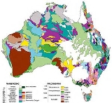
Components
Australia's geology can be divided into several main sections; the Archaean cratonCraton
A craton is an old and stable part of the continental lithosphere. Having often survived cycles of merging and rifting of continents, cratons are generally found in the interiors of tectonic plates. They are characteristically composed of ancient crystalline basement rock, which may be covered by...
ic shields, Proterozoic
Proterozoic
The Proterozoic is a geological eon representing a period before the first abundant complex life on Earth. The name Proterozoic comes from the Greek "earlier life"...
fold belt
Orogeny
Orogeny refers to forces and events leading to a severe structural deformation of the Earth's crust due to the engagement of tectonic plates. Response to such engagement results in the formation of long tracts of highly deformed rock called orogens or orogenic belts...
s and sedimentary basin
Sedimentary basin
The term sedimentary basin is used to refer to any geographical feature exhibiting subsidence and consequent infilling by sedimentation. As the sediments are buried, they are subjected to increasing pressure and begin the process of lithification...
s, Phanerozoic
Phanerozoic
The Phanerozoic Eon is the current eon in the geologic timescale, and the one during which abundant animal life has existed. It covers roughly 542 million years and goes back to the time when diverse hard-shelled animals first appeared...
sedimentary basins, and Phanerozoic metamorphic and igneous rocks.
Australia as a separate continent began to form after the breakup of Gondwana
Gondwana
In paleogeography, Gondwana , originally Gondwanaland, was the southernmost of two supercontinents that later became parts of the Pangaea supercontinent. It existed from approximately 510 to 180 million years ago . Gondwana is believed to have sutured between ca. 570 and 510 Mya,...
in the Permian, with the separation of the continental landmass from the African continent and Indian subcontinent. Australia rifted from Antarctica in the Cretaceous.
The current Australian continental mass is composed of a thick subcontinental lithosphere
Lithosphere
The lithosphere is the rigid outermost shell of a rocky planet. On Earth, it comprises the crust and the portion of the upper mantle that behaves elastically on time scales of thousands of years or greater.- Earth's lithosphere :...
, over 200 km thick in the western two thirds and 100 km thick in the younger eastern third. The Australian continental crust
Continental crust
The continental crust is the layer of igneous, sedimentary, and metamorphic rocks which form the continents and the areas of shallow seabed close to their shores, known as continental shelves. This layer is sometimes called sial due to more felsic, or granitic, bulk composition, which lies in...
, excluding the thinned margins, has an average thickness of 38 km, with a range in thickness from 24 km to 59 km. The continental crust is composed primarily of Archaean, Proterozoic and some Palaeozoic granites and gneisses. A thin veneer of mainly Phanerozoic
Phanerozoic
The Phanerozoic Eon is the current eon in the geologic timescale, and the one during which abundant animal life has existed. It covers roughly 542 million years and goes back to the time when diverse hard-shelled animals first appeared...
sedimentary basins cover much of the Australian landmass (these are up to 7 km thick). These in turn are currently undergoing erosion by a combination of aeolian and fluvial processes, forming extensive sand dune systems, deep and prolonged development of laterite
Laterite
Laterites are soil types rich in iron and aluminium, formed in hot and wet tropical areas. Nearly all laterites are rusty-red because of iron oxides. They develop by intensive and long-lasting weathering of the underlying parent rock...
and saprolite
Saprolite
Saprolite is a chemically weathered rock. Saprolites form in the lower zones of soil profiles and represent deep weathering of the bedrock surface. In most outcrops its color comes from ferric compounds...
profiles, and development of playa lakes, salt lakes and ephemeral drainage.
Blocks
The main continental blocks of the Australian continent are;- The Yilgarn CratonYilgarn cratonThe Yilgarn Craton is a large craton which constitutes the bulk of the Western Australian land mass. It is bounded by a mixture of sedimentary basins and Proterozoic fold and thrust belts...
, of Archaean age - The Pilbara CratonPilbara cratonThe Pilbara craton , along with the Kaapvaal craton are the only remaining areas of pristine Archaean 3.6-2.7 Ga crust on Earth...
of Archaean to Proterozoic age - The Gawler CratonGawler cratonThe Gawler Craton covers approximately 440,000 square kilometres of central South Australia. Its Precambrian crystalline basement crustal block was cratonised ca. 1550-1450 Ma...
and Willyama Block, of Archaean to Proterozoic age.
These are in turn flanked by several Proterozoic orogenic belts and sedimentary basins, notably the
- Musgrave BlockMusgrave BlockThe Musgrave Block is an east-west trending belt of Proterozoic granulite-gneiss basement rocks approximately 500km long. The Musgrave Block extends from western South Australia into Western Australia....
of granuliteGranuliteGranulites are medium to coarse–grained metamorphic rocks that have experienced high temperature metamorphism, composed mainly of feldspars sometimes associated with quartz and anhydrous ferromagnesian minerals, with granoblastic texture and gneissose to massive structure...
gneissGneissGneiss is a common and widely distributed type of rock formed by high-grade regional metamorphic processes from pre-existing formations that were originally either igneous or sedimentary rocks.-Etymology:...
and igneous rocks - The Arunta Block of amphiboliteAmphiboliteAmphibolite is the name given to a rock consisting mainly of hornblende amphibole, the use of the term being restricted, however, to metamorphic rocks. The modern terminology for a holocrystalline plutonic igneous rocks composed primarily of hornblende amphibole is a hornblendite, which are...
grade metamorphic rocks and granites - The Gascoyne ComplexGascoyne ComplexThe Gascoyne Complex is a terrane of Proterozoic granite and metamorphic rock in the central-western part of Western Australia. The complex outcrops at the exposed western end of the Capricorn Orogen, a 1,000 km-long arcuate belt of folded, faulted and metamorphosed rocks between two Archean...
, Glengarry Basin, and Bangemall Basin sandwiched between the Yilgarn and Arunta Blocks
Geological history
The geological history of the Australian continental mass is extremely prolonged and involved, continuing from the Archaean to the recent. In a gross pattern, continental Australia grew from west to east, with Archean rocks mostly in the west, Proterozoic rocks in the centre, and Phanerozoic rocks in the east. Recent geological events are confined to intraplate earthquakes, as the continent of Australia sits distant from the plate boundary.The Australian continent evolved in five broad but distinct time periods, namely: 3800–2100 Ma, 2100–1300 Ma, 1300–600 Ma, 600–160 Ma and 160 Ma to the present. The first period saw the growth of nuclei about which cratonic elements grew, whereas the latter four periods involved the amalgamation and dispersal of Nuna
Nuna
Nuna is the name of a series of manned solar powered vehicles that won the World solar challenge in Australia four times in a row, in 2001 , 2003 , 2005 and 2007...
, Rodinia
Rodinia
In geology, Rodinia is the name of a supercontinent, a continent which contained most or all of Earth's landmass. According to plate tectonic reconstructions, Rodinia existed between 1.1 billion and 750 million years ago, in the Neoproterozoic era...
and Pangea-Gondwana, respectively.
Tectonic setting
The Australian landmass has been part of all major supercontinentSupercontinent
In geology, a supercontinent is a landmass comprising more than one continental core, or craton. The assembly of cratons and accreted terranes that form Eurasia qualifies as a supercontinent today.-History:...
s, but its association with Gondwana
Gondwana
In paleogeography, Gondwana , originally Gondwanaland, was the southernmost of two supercontinents that later became parts of the Pangaea supercontinent. It existed from approximately 510 to 180 million years ago . Gondwana is believed to have sutured between ca. 570 and 510 Mya,...
is especially notable as important correlations have been made geologically with the African continental mass and Antarctica.
Australia separated from Antarctica over a prolonged period beginning in the Permian
Permian
The PermianThe term "Permian" was introduced into geology in 1841 by Sir Sir R. I. Murchison, president of the Geological Society of London, who identified typical strata in extensive Russian explorations undertaken with Edouard de Verneuil; Murchison asserted in 1841 that he named his "Permian...
and continuing through to the Cretaceous
Cretaceous
The Cretaceous , derived from the Latin "creta" , usually abbreviated K for its German translation Kreide , is a geologic period and system from circa to million years ago. In the geologic timescale, the Cretaceous follows the Jurassic period and is followed by the Paleogene period of the...
(84 Ma).
New Zealand
New Zealand is an island country in the south-western Pacific Ocean comprising two main landmasses and numerous smaller islands. The country is situated some east of Australia across the Tasman Sea, and roughly south of the Pacific island nations of New Caledonia, Fiji, and Tonga...
, Indonesia
Indonesia
Indonesia , officially the Republic of Indonesia , is a country in Southeast Asia and Oceania. Indonesia is an archipelago comprising approximately 13,000 islands. It has 33 provinces with over 238 million people, and is the world's fourth most populous country. Indonesia is a republic, with an...
and New Guinea
New Guinea
New Guinea is the world's second largest island, after Greenland, covering a land area of 786,000 km2. Located in the southwest Pacific Ocean, it lies geographically to the east of the Malay Archipelago, with which it is sometimes included as part of a greater Indo-Australian Archipelago...
, and the Himalaya (transmitted through the Indian and Capricorn plates). South of latitude -30º, the stress trajectories are oriented east–west to northwest–southeast. North of this latitude, the stress trajectories are closer to the present day plate motion, being oriented east-northeast–west-southwest to northeast–southwest. Notably, the main stress trajectories diverge most markedly from one another in north–central New South Wales (east–southeast to north–northeast), although the area is not known historically for earthquake activity. Young mountain building (< 5 Ma) in the Flinders Ranges
Flinders Ranges
Flinders Ranges is the largest mountain range in South Australia, which starts approximately north west of Adelaide. The discontinuous ranges stretch for over from Port Pirie to Lake Callabonna...
of South Australia is driven from plate convergence at the boundary in New Zealand
New Zealand
New Zealand is an island country in the south-western Pacific Ocean comprising two main landmasses and numerous smaller islands. The country is situated some east of Australia across the Tasman Sea, and roughly south of the Pacific island nations of New Caledonia, Fiji, and Tonga...
.
Australia is currently moving toward Eurasia at the rate of 6-7 centimetres a year.
Archaean
There are three main cratonCraton
A craton is an old and stable part of the continental lithosphere. Having often survived cycles of merging and rifting of continents, cratons are generally found in the interiors of tectonic plates. They are characteristically composed of ancient crystalline basement rock, which may be covered by...
ic shields of recognised Archaean age within the Australian landmass: The Yilgarn
Yilgarn craton
The Yilgarn Craton is a large craton which constitutes the bulk of the Western Australian land mass. It is bounded by a mixture of sedimentary basins and Proterozoic fold and thrust belts...
, the Pilbara
Pilbara craton
The Pilbara craton , along with the Kaapvaal craton are the only remaining areas of pristine Archaean 3.6-2.7 Ga crust on Earth...
and the Gawler
Gawler craton
The Gawler Craton covers approximately 440,000 square kilometres of central South Australia. Its Precambrian crystalline basement crustal block was cratonised ca. 1550-1450 Ma...
cratons. Several other Archaean-Proterozoic orogenic belts exist, usually sandwiched around the edges of these major cratonic shields.
The history of the Archaean cratons is extremely complex and protracted. The cratons appear to have been assembled to form the greater Australian landmass in the late Archaean to mesoProterozoic, (~2400 Ma to 1,600 Ma).
Chiefly the Capricorn Orogeny is partly responsible for the assembly of the West Australian landmass by joining the Yilgarn and Pilbara cratons. The Capricorn Orogeny is exposed in the rocks of the Bangemall Basin, Gascoyne Complex
Gascoyne Complex
The Gascoyne Complex is a terrane of Proterozoic granite and metamorphic rock in the central-western part of Western Australia. The complex outcrops at the exposed western end of the Capricorn Orogen, a 1,000 km-long arcuate belt of folded, faulted and metamorphosed rocks between two Archean...
granite
Granite
Granite is a common and widely occurring type of intrusive, felsic, igneous rock. Granite usually has a medium- to coarse-grained texture. Occasionally some individual crystals are larger than the groundmass, in which case the texture is known as porphyritic. A granitic rock with a porphyritic...
-gneiss
Gneiss
Gneiss is a common and widely distributed type of rock formed by high-grade regional metamorphic processes from pre-existing formations that were originally either igneous or sedimentary rocks.-Etymology:...
es and the Glengarry, Yerrida and Padbury basins. Unknown Proterozoic orogenic belts, possibly similar to the Albany Complex in southern Western Australia and the Musgrave Block
Musgrave Block
The Musgrave Block is an east-west trending belt of Proterozoic granulite-gneiss basement rocks approximately 500km long. The Musgrave Block extends from western South Australia into Western Australia....
, represent the Proterozoic link between the Yilgarn and Gawler cratons, covered by the Proterozoic-Palaeozoic Officer
Officer Basin
The Officer Basin is a large intracratonic sedimentary basin in Australia, lying across the states of South Australia and Western Australia. It is named after Officer Creek which is a watercourse that drains a small part of the basin. Deposition of up to 10 km of marine and non-marine sedimentary...
and Amadeus
Amadeus Basin
The Amadeus Basin is a large intracratonic sedimentary basin in central Australia, lying mostly within the southern Northern Territory, but extending into the state of Western Australia. It is named after Lake Amadeus which lies within the basin...
basins
Sedimentary basin
The term sedimentary basin is used to refer to any geographical feature exhibiting subsidence and consequent infilling by sedimentation. As the sediments are buried, they are subjected to increasing pressure and begin the process of lithification...
.
See also:
- Narryer Gneiss TerraneNarryer Gneiss TerraneThe Narryer Gneiss Terrane is a geological complex in Western Australia that is composed of a tectonically interleaved and polydeformed mixture of granite, mafic intrusions and metasedimentary rocks in excess of 3.3 billion years old, with the majority of the Narryer Gneiss Terrane in excess of 3.6...
Palaeoproterozoic
Western Australian EventsThe assembly of the Archaean Yilgarn and Pilbara cratons of Australia was initiated at ~2200 Ma during the first phases of the Capricorn orogen.
The last stages of the 2770-2300 Ma Hamersley Basin on the southern margin of the Pilbara Craton are Palaeoproterozoic and record the last stable submarine-fluviatile environments between the two cratons prior to the rifting, contraction and assembly of the intracratonic ~1800 Ma Ashburton and Blair basins, the 1600-1070 Ma Edmund and Collier basins , the 1840-1620 Ma northern Gascoyne Complex
Gascoyne Complex
The Gascoyne Complex is a terrane of Proterozoic granite and metamorphic rock in the central-western part of Western Australia. The complex outcrops at the exposed western end of the Capricorn Orogen, a 1,000 km-long arcuate belt of folded, faulted and metamorphosed rocks between two Archean...
, the 2000-1780 Ma Glenburgh Terrane in the southern Gascoyne Complex and the Errabiddy Shear Zone at the northwestern margin of the Yilgarn Craton.
Between approximately 2000-1800 Ma, on the northern margin of the Yilgarn Craton, the c. 1890 Ma Narracoota Volcanics of the Bryah Basin formed in a transverse back-arc rift sag basin during collision. Culmination of the cratonic collision resulted in the foreland sedimentary Padbury Basin. To the east the Yerrida and Eerarheedy Basins were passive margins along the Yilgarn's northern margin.
The c. 1830 Ma phase of the Capricorn Orogeny in this section of the Pilbara-Yilgarn boundary resulted in deformation of the Bryah-Padbury Basin and the western fringe of the Yerrida Basin, along with flood basalts. The Yapungku Orogeny (~1790 Ma) formed the Stanley Fold Belt on the northern margin of the Eerarheedy Basin, via assembly of the Archaean-Proterozoic fold belts of Northern Australia.
East Australian Events
The Palaeoproterozoic in southeastern Australia is represented by the polydeformed high-grade gneiss terranes of the Willyama Supergroup, Olary Block and Broken Hill Block, in South Australia and New South Wales. The Palaeoproterozoic in the north of Australia is represented mostly by the Mount Isa
Mount Isa, Queensland
-Culture and sport:The local theatre group, the Mount Isa Theatrical Society, or MITS, often holds plays and musicals, at least once every few months or so....
Block and complex fold-thrust belts.
These rocks, aside from suffering intense deformation, record a period of widespread platform cover sedimentation, ensialic rift-sag sedimentation including widespread dolomite platform cover, and extensive phosphorite deposition in the deeper sea beds.
Mesoproterozoic
The oldest rocks in TasmaniaGeology of Tasmania
Tasmania has a complex geological history, with the world's biggest exposure of diabase, or dolerite. The rock record contains representatives of each period of the Neoproterozoic, Paleozoic, Mesozoic and Cainozoic eras. It is one of the few southern hemisphere areas glaciated during the...
formed in the Mesoproterozoic
Mesoproterozoic
The Mesoproterozoic Era is a geologic era that occurred between 1600 Ma and 1000 Ma . The Mesoproterozoic was the first period of Earth's history with a respectable geological record. Continents existed in the Paleoproterozoic, but we know little about them...
on King Island and in the Tyennan Block.
Neoproterozoic
Neoproterozoic events include,- the Giles Complex mafic-ultramafic intrusions in the Musgrave Block at ~1080 Ma
- widespread sills in the Bangemall Basin and the Glenayle area at ~1080 Ma
- The Warukurna Large Igneous Province of ~1080Ma
Cambrian
The Stavely ZoneGeology of Victoria
Victoria is an Australian state, situated at the southern end of the Great Dividing Range. The Great Dividing Range stretches along the east coast of the continent and terminates near the Victorian city of Ballarat west of the capital Melbourne, though the nearby Grampians may be considered to be...
in Victoria is a boninite to MORB basalt terrane considered to have been connected with the boninites the Mount Read Volcanics of Northern Tasmania. In New South Wales, extensive deepwater sedimentation formed the Adaminaby Beds in Victoria and New South Wales. The Lachlan Fold Belt
Lachlan Fold Belt
The Lachlan Fold Belt or Lachlan Orogen is a geological subdivision of the east part of Australia. It is a zone of folded and faulted rocks of similar age. It dominates New South Wales and Victoria, also extending into Tasmania, the Australian Capital Territory and Queensland. It was formed in...
ophiolite sequences are considered to be of Cambrian age, and are obducted during the Lachlan Orogen.
The Petermann Orogeny
Petermann Orogeny
The Petermann Orogeny was an intracontinental event that affected basement rocks of the northern Musgrave Province and Proterozoic sediments of the southern Amadeus Basin between ~550-535 Ma....
in Central Australia occurred in the Cambrian, shedding a thick intracontinental sequence of fluvial sediments into the central Australian landmass. Marginal platforms and passive margin basins existed in South Australia - - formed in the foreland of the Delamerian Orogeny. Western Australian passive margin basins and platform cover begin at this stage.
The extensive Antrim Plateau flood basalts, covering in excess of 12,000 square kilometres, erupt in the Cambrian of Western Australia, providing a useful chronostratigraphic marker.
- Stansbury basin
- Gascoyne Sub-basin - begins Cambrian, through to Tertiary
- Bonaparte Gulf Basin
Ordovician
OrdovicianOrdovician
The Ordovician is a geologic period and system, the second of six of the Paleozoic Era, and covers the time between 488.3±1.7 to 443.7±1.5 million years ago . It follows the Cambrian Period and is followed by the Silurian Period...
geological events in Australia involved Alpinotype orogeny
Orogeny
Orogeny refers to forces and events leading to a severe structural deformation of the Earth's crust due to the engagement of tectonic plates. Response to such engagement results in the formation of long tracts of highly deformed rock called orogens or orogenic belts...
in the Lachlan Fold Belt
Lachlan Fold Belt
The Lachlan Fold Belt or Lachlan Orogen is a geological subdivision of the east part of Australia. It is a zone of folded and faulted rocks of similar age. It dominates New South Wales and Victoria, also extending into Tasmania, the Australian Capital Territory and Queensland. It was formed in...
, resulting in the great serpentinite
Serpentinite
Serpentinite is a rock composed of one or more serpentine group minerals. Minerals in this group are formed by serpentinization, a hydration and metamorphic transformation of ultramafic rock from the Earth's mantle...
belts of western New South Wales, and accretion of deepwater molasse
Molasse
The term "molasse" refers to the sandstones, shales and conglomerates formed as terrestrial or shallow marine deposits in front of rising mountain chains. The molasse is deposited in a foreland basin, especially on top of flysch, for example that left from the rising Alps, or erosion in the Himalaya...
and flysch
Flysch
Flysch is a sequence of sedimentary rocks that is deposited in a deep marine facies in the foreland basin of a developing orogen. Flysch is typically deposited during an early stage of the orogenesis. When the orogen evolves the foreland basin becomes shallower and molasse is deposited on top of...
exemplified by the slate
Slate
Slate is a fine-grained, foliated, homogeneous metamorphic rock derived from an original shale-type sedimentary rock composed of clay or volcanic ash through low-grade regional metamorphism. The result is a foliated rock in which the foliation may not correspond to the original sedimentary layering...
belts of Victoria and eastern New South Wales.
Victoria - 490-440 Ma
The late Cambrian to early Ordovician saw deepwater sedimentation of the St Arnaud and Castlemaine Group turbidites, which are now emplaced in the Stawell and Bendigo Zones. The middle Ordovician saw the deposition of the Sunbury Group in the Melbourne Zone, Bendoc Group and formation of the Molong Arc, a calc-alkaline volcanic arc which is related to the Kiandra Group turbidites.
Ordovician orogenies include the Lachlan Orogeny.
Silurian
During the SilurianSilurian
The Silurian is a geologic period and system that extends from the end of the Ordovician Period, about 443.7 ± 1.5 Mya , to the beginning of the Devonian Period, about 416.0 ± 2.8 Mya . As with other geologic periods, the rock beds that define the period's start and end are well identified, but the...
Period most of the Australian continent in the west and centre was dry land. However from Geraldton north to Exmouth Gulf
Exmouth Gulf
Exmouth Gulf is a gulf in the north west of Western Australia. It lies between North West Cape and the main coastline of Western Australia. It is considered to be part of the region of the North West Shelf and in the Canning Basin area.-Environment:...
along the far Western Australian coast a fluvial sediment basin
Sediment basin
A sediment basin is a temporary pond built on a construction site to capture eroded or disturbed soil that is washed off during rain storms, and protect the water quality of a nearby stream, river, lake, or bay. The sediment-laden soil settles in the pond before the runoff is discharged...
existed. Near Kalbarri on the Murchison River
Murchison River (Western Australia)
The Murchison River is the second longest river in Western Australia. It flows for about from the southern edge of the Robinson Ranges to the Indian Ocean at Kalbarri. It has a mean annual flow of about 200 million cubic metres.-Course:...
the footprints of a giant water scorpion were found on land, the first animal to walk on the Australian continent. A gulf linked to the sea existed under what is now the Great Sandy Desert
Great Sandy Desert
The Great Sandy Desert is a desert located in the North West of Western Australia straddling the Pilbara and southern Kimberley regions. It is the second largest desert in Australia after the Great Victoria Desert and encompasses an area of...
. Meanwhile in the east there were volcanic arcs in New England, also west of Townsville and Cairns, and in NSW and Victoria and the Australian Capital Territory. Deep water sediments formed in the Cowra, Tumut and Hillend Troughs. The Yass Molong rise was a row of volcanoes. Granite
Granite
Granite is a common and widely occurring type of intrusive, felsic, igneous rock. Granite usually has a medium- to coarse-grained texture. Occasionally some individual crystals are larger than the groundmass, in which case the texture is known as porphyritic. A granitic rock with a porphyritic...
intrusions formed in New South Wales and Victoria from 435 to 425 Mya, with the Bega batholith as young as 400 Mya. In NSW granites the distinction between I-type and S-type granites was discovered.
Devonian
During the DevonianDevonian
The Devonian is a geologic period and system of the Paleozoic Era spanning from the end of the Silurian Period, about 416.0 ± 2.8 Mya , to the beginning of the Carboniferous Period, about 359.2 ± 2.5 Mya...
Period conditions were warm in Australia. There was a large bay in the great Sandy Desert with reefs. The Calliope Arc went from the north of Rockhampton south to Grafton. Most of the centre and west of Australia was land mass. There were volcanic mountains off the current east coast supplying sediment into a basin on parts of the east. The basin contained limestone and river deposited sand. Andesite and Rhyolite volcanoes were found in central NSW, the Snowy Mountains, Eden, New England and near Clermont, Queensland
Clermont, Queensland
Clermont is an agricultural town in the Isaac Region, Queensland, Australia. It is 274 km south-west of Mackay on the junction of the Gregory and Peak Downs highways...
. Baragwanathia
Baragwanathia
Baragwanathia is a genus of extinct plants of the division Lycopodiophyta of Late Silurian to Early Devonian age , fossils of which have been found in Australia, Canada and China.-Description:...
longifolia was the first Australian land plant appearing at this time.
The Tabberabberan Orogeny compressed the eastern seaboard in an east west direction, with Tasmania, Victoria and southern New South Wales folded 385 - 380 Mya. Northern NSW and Queensland was compressed 377 to 352 Mya. A major river drained the continental interior and passed eastwards at Parkes. The Bungle Bungle Range
Bungle Bungle Range
Bungle Bungle Range is the landform that is the major component of the Purnululu National Park in Western Australia - it is often used as a direct synonym for the national park area.-The origin of the landscape :...
sandstone was formed in Western Australia from river sands. More Granite was intruded in the Devonian.
The Connors Arc and Baldwin arc formed behind Mackay and Western New England.
Carboniferous
The Carboniferous Period saw the Eastern Highlands of Australia form as a result of its collsion with what are now parts of South AmericaSouth America
South America is a continent situated in the Western Hemisphere, mostly in the Southern Hemisphere, with a relatively small portion in the Northern Hemisphere. The continent is also considered a subcontinent of the Americas. It is bordered on the west by the Pacific Ocean and on the north and east...
(e.g. the Sierra de Cordoba
Sierra de Córdoba
The Sierras de Córdoba is a mountain range in central Argentina, located between the Pampas to the east and south, the Chaco to the north and the foothills of the Andes to the west...
) and New Zealand
New Zealand
New Zealand is an island country in the south-western Pacific Ocean comprising two main landmasses and numerous smaller islands. The country is situated some east of Australia across the Tasman Sea, and roughly south of the Pacific island nations of New Caledonia, Fiji, and Tonga...
.
At the time they were formed they are believed to have been as high as any mountains on the planet today, but they have been almost completely eroded in the 280 million years since.
Another notable feature of Carboniferous Australia was a major ice age
Ice age
An ice age or, more precisely, glacial age, is a generic geological period of long-term reduction in the temperature of the Earth's surface and atmosphere, resulting in the presence or expansion of continental ice sheets, polar ice sheets and alpine glaciers...
which left over half of the continent glaciated. Evidence for the cold conditions can be seen not only in glacial features dating from this period but also in fossil Gelisols
Gelisols
Gelisols are an order in USDA soil taxonomy. They are soils of very cold climates which are defined as containing permafrost within two meters of the soil surface...
from as far north as the Hunter River
Hunter River
The Hunter River is a major river in New South Wales, Australia. The Hunter River rises in the Liverpool Range and flows generally south and then east, reaching the Pacific Ocean at Newcastle, the second largest city in New South Wales and a major port....
basin.
Permo-Triassic
The PermianPermian
The PermianThe term "Permian" was introduced into geology in 1841 by Sir Sir R. I. Murchison, president of the Geological Society of London, who identified typical strata in extensive Russian explorations undertaken with Edouard de Verneuil; Murchison asserted in 1841 that he named his "Permian...
to Triassic
Triassic
The Triassic is a geologic period and system that extends from about 250 to 200 Mya . As the first period of the Mesozoic Era, the Triassic follows the Permian and is followed by the Jurassic. Both the start and end of the Triassic are marked by major extinction events...
in Australia is dominated by subduction zones on the eastern margin of the landmass, part of the Hunter-Bowen Orogeny
Hunter-Bowen orogeny
The Hunter-Bowen Orogeny was a significant arc accretion event in the Permian and Triassic periods affecting approximately 2,500 km of the Australian continental margin....
. This was a major arc-accretion, subduction and back-arc sedimentary basin forming event which persisted episodically from approximately late Carboniferous in its initial stages, through the Permian and terminated in the Middle Triassic at around 229Ma to 225Ma.
In Western and Central Australia the then-extensive central Australian mountain ranges such as the Petermann Ranges were eroded by the Permian glacial event, resulting in thick marine to fluvial glacial tillite and fossiliferous limestone deposits and extensive platform cover. Rifting of Australia from India and Africa began in the Permian, resulting in the production of a rift basin and half-grabens of the basal portions of the long-lived Perth Basin
Perth basin
The Perth Basin is a thick sedimentary basin in Western Australia. It lies beneath the Swan Coastal Plain west of the Darling Scarp, representing the western limit of the much older Yilgarn Craton, and extends further west offshore...
. Petroleum
Petroleum
Petroleum or crude oil is a naturally occurring, flammable liquid consisting of a complex mixture of hydrocarbons of various molecular weights and other liquid organic compounds, that are found in geologic formations beneath the Earth's surface. Petroleum is recovered mostly through oil drilling...
was formed in the Swan Coastal Plain
Swan Coastal Plain
The Swan Coastal Plain in Western Australia is the geographic feature which contains the Swan River as it travels west to the Indian Ocean. The coastal plain continues well beyond the boundaries of the Swan River and its tributaries, as a geological and biological zone, one of Western Australia's...
and Pilbara during this rifting, presumably in a rift valley lake where the bottom was deoxygenated (akin to Africa's Lake Tanganyika
Lake Tanganyika
Lake Tanganyika is an African Great Lake. It is estimated to be the second largest freshwater lake in the world by volume, and the second deepest, after Lake Baikal in Siberia; it is also the world's longest freshwater lake...
today)
See also:
- Perth BasinPerth basinThe Perth Basin is a thick sedimentary basin in Western Australia. It lies beneath the Swan Coastal Plain west of the Darling Scarp, representing the western limit of the much older Yilgarn Craton, and extends further west offshore...
- Bowen BasinBowen BasinThe Bowen Basin contains the largest coal reserves in Australia. This major coal producing region contains one of the world's largest deposits of bituminous coal. The Basin contains much of the known Permian coal resources in Queensland including virtually all of the known mineable prime coking coal...
- Gunnedah basin
- Sydney basinSydney BasinThe Sydney Basin is a sedimentary basin on the east coast of New South Wales, Australia consisting of Permian and Triassic sedimentary rocks...
- Ipswich basin/Clarence-Moreton Basin
Jurassic
In the west of Australia the JurassicJurassic
The Jurassic is a geologic period and system that extends from about Mya to Mya, that is, from the end of the Triassic to the beginning of the Cretaceous. The Jurassic constitutes the middle period of the Mesozoic era, also known as the age of reptiles. The start of the period is marked by...
was a tropical savannah to jungle environment, shown by advanced tropical weathering preserved in the regolith
Regolith
Regolith is a layer of loose, heterogeneous material covering solid rock. It includes dust, soil, broken rock, and other related materials and is present on Earth, the Moon, some asteroids, and other terrestrial planets and moons.-Etymology:...
of the Yilgarn craton
Yilgarn craton
The Yilgarn Craton is a large craton which constitutes the bulk of the Western Australian land mass. It is bounded by a mixture of sedimentary basins and Proterozoic fold and thrust belts...
which is still preserved today.
Australia began rifting away from Antarctica in the Jurassic, which formed the Gippsland, Bass and Otway Basins in Victoria and the offshore shelf basins of South Australia and Western Australia, all of which host significant oil and gas deposits.
Jurassic coal-bearing basins were formed in north central Queensland, with significant marine platform cover extending across most of central Australia.
Continued passive-margin subsidence and marine transgressions in the Perth Basin of Western Australia continued, with the Jurassic Cattamarra Coal
Coal
Coal is a combustible black or brownish-black sedimentary rock usually occurring in rock strata in layers or veins called coal beds or coal seams. The harder forms, such as anthracite coal, can be regarded as metamorphic rock because of later exposure to elevated temperature and pressure...
Measures a notable fluvial terrigenous formation of the Jurassic.
See also
- Surat BasinSurat BasinThe Surat Basin is a part of the Great Artesian Basin of Australia. The Surat Basin extends across an area of 270,000 square kilometres and the southern third of the basin occupies a large part of northern New South Wales, the remainder is in Queensland. It comprises Jurassic through to Cretaceous...
- Perth BasinPerth basinThe Perth Basin is a thick sedimentary basin in Western Australia. It lies beneath the Swan Coastal Plain west of the Darling Scarp, representing the western limit of the much older Yilgarn Craton, and extends further west offshore...
Cretaceous
The initial rifting of Australia and Antarctica in the Jurassic continued through the Cretaceous, with offshore development of a mid ocean ridge seafloor spreading centre. Tasmania was rifted off during this stage.Cretaceous
Cretaceous
The Cretaceous , derived from the Latin "creta" , usually abbreviated K for its German translation Kreide , is a geologic period and system from circa to million years ago. In the geologic timescale, the Cretaceous follows the Jurassic period and is followed by the Paleogene period of the...
volcanism in the offshore of Queensland
Queensland
Queensland is a state of Australia, occupying the north-eastern section of the mainland continent. It is bordered by the Northern Territory, South Australia and New South Wales to the west, south-west and south respectively. To the east, Queensland is bordered by the Coral Sea and Pacific Ocean...
was related to a minor episode of arc formation, typified by the Whitsunday Islands
Whitsunday Islands
The Whitsunday Islands are a collection of continental islands of various sizes off the central coast of Queensland, Australia, situated between just south of Bowen and to the north of Mackay, some north of Brisbane. The island group is centred on Whitsunday Island, while the group's commercial...
, followed by development of offshore coral platforms, passive margin basins and far-field volcanism throughout the quiet Hunter-Bowen orogenic belt.
Cretaceous sedimentation continued in the Surat Basin. Some small Cretaceous volcanism was present at the edges of basement highs in the Great Artesian Basin, resulting in some sparse volcanic plugs today.
Cretaceous sedimentation continued in the Perth Basin
Perth basin
The Perth Basin is a thick sedimentary basin in Western Australia. It lies beneath the Swan Coastal Plain west of the Darling Scarp, representing the western limit of the much older Yilgarn Craton, and extends further west offshore...
.
Tertiary
The TertiaryTertiary
The Tertiary is a deprecated term for a geologic period 65 million to 2.6 million years ago. The Tertiary covered the time span between the superseded Secondary period and the Quaternary...
saw the majority of Australian tectonism cease. Sparse examples of intraplate volcanism exist, for instance the Glasshouse Mountains in Queensland, which are Tertiary examples of a chain of small volcanic plugs which decrease in age to the south, where they result in ~10,000 year old maar
Maar
A maar is a broad, low-relief volcanic crater that is caused by a phreatomagmatic eruption, an explosion caused by groundwater coming into contact with hot lava or magma. A maar characteristically fills with water to form a relatively shallow crater lake. The name comes from the local Moselle...
volcanoes and basalts of the Newer Volcanics
Newer Volcanics Province
The Newer Volcanics Province is a complex of volcanic centres formed by the East Australia hotspot across south-eastern Australia. It has an area of 6,000 square miles with over 400 vents and contains the youngest volcanoes in Australia...
in South Australia and Victoria
Victoria (Australia)
Victoria is the second most populous state in Australia. Geographically the smallest mainland state, Victoria is bordered by New South Wales, South Australia, and Tasmania on Boundary Islet to the north, west and south respectively....
.
Geology Maps
See also - by state and territory
- Geology of the Australian Capital Territory
- Geology of TasmaniaGeology of TasmaniaTasmania has a complex geological history, with the world's biggest exposure of diabase, or dolerite. The rock record contains representatives of each period of the Neoproterozoic, Paleozoic, Mesozoic and Cainozoic eras. It is one of the few southern hemisphere areas glaciated during the...
- Geology of VictoriaGeology of VictoriaVictoria is an Australian state, situated at the southern end of the Great Dividing Range. The Great Dividing Range stretches along the east coast of the continent and terminates near the Victorian city of Ballarat west of the capital Melbourne, though the nearby Grampians may be considered to be...
:Category:Geology of Western Australia