
Geology of Tasmania
Encyclopedia
Tasmania
has a complex geological history, with the world's biggest exposure of diabase, or dolerite
. The rock record contains representatives of each period of the Neoproterozoic
, Paleozoic
, Mesozoic
and Cainozoic eras. It is one of the few southern hemisphere areas glaciated during the Pleistocene
with glacial landforms in the higher parts. The west coast region hosts significant mineralisation and numerous active and historic mines.
. After this there are many signs of glaciation from the Cryogenian
, as well as the global warming
that occurred at the start of the Ediacaran
period. An orogeny
folded the older Precambrian
rocks. In the Cambrian
time the Tyennan block forming the south west
and central Tasmania, was pushed up and slightly over the land of north west Tasmania, the Tyennan Orogeny. Then there were volcanic action and sediments from the Cambrian and Ordovician
. The large ore deposits were formed on the West Coast
. The north east of Tasmania began to form as part of the Lachlan Orogen with turbidity flows of mud and sand on to the ocean floor. In the Devonian the Taberabban Orogeny caused more folding, and intrusion of granite
on the west and east coasts, and probably joined the east of Tasmania to the west.
In the Permian
period, conditions were again glacial and the Tasmania basin formed, with low sea levels in the Triassic
. A giant intrusion of magma happened in the Jurassic
forming diabase
, or dolerite which gives many of the Tasmanian mountains their characteristic appearance. Continental breakup happened in the Cretaceous
and Tertiary
Periods, splitting off undersea plateaus, forming Bass Strait
and ultimately breaking Tasmania away from Antarctica. In the Tertiary, a couple of basins extended inland from Macquarie Harbour
and the northern Midlands. The higher mountains were glaciated during the Pleistocene
.
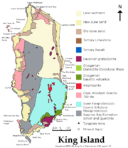 On King Island now in Bass Strait, the oldest Tasmanian rocks are found. On the west side of King Island, there are basalt
s that have been metamorphosed by amphibolite
grade metamorphism at . Sedimentary rocks such as feldspathic sandstone that have been altered to schist
and quartzite. A dolerite sill
was intruded. Granite intruded in the Cryogenian. The granite contains inherited zircon
s from . The Wickham deformation affected the earlier rocks by heating to 470 to 480 °C at pressures below 300 MPa
, and tight folding
. This was followed later in the Neoproterozoic
on the eastern side of the island with beds of diamictite
, dolomite
, mudstone
, tholeiite
, and picrite interleaved with conglomerate
. Also dykes
of augite
syenite
, picrite and tholeiite dolerite were intruded. An interpretation is that deposits occurred in a tidal area, with a continental
rift
allowing magma
from the mantle
to intrude. These newer Proterozoic sediments were then tilted and faulted.
In the Rocky Cape Block west of Wynyard
and north of Granville Harbour, the Precambrian rocks consist of the Rocky Cape group from the Stenian
period, with Cowrie Siltstone
, Detention Subgroup, Irby Siltstone, and Jacob Quartzite. The sequence covers most of the element and is over 5700 meters thick. Currents travelled either northwesterly or southeasterly. The metamorphic belt titled the Arthur Lineament forms the limits of the Rocky Cape Group to the south east. The Burnie Formation followed in the Tonian
period south east of the lineament with greywacke
and slaty mudstone, and also some basic pillow lava
s. The Oonah Formation has even more varieties of rock than the Burnie formation, also including conglomerate, quartz sandstone, dolomite and chert
. The Bowry Formation in the Cryogenian was intruded by granite (Bowry granitoids) . These have been metamorphosed to the blueschist
level. In the Smithton Synclinorium the Togari Group followed with conglomerate from the Sturtian and Marinoan glaciation
s and dolomite marking the end of Cryogenian and on into the Ediacaran and Cambrian. The Togari group contains greywacke, conglomerate, diamictite, mafic volcanic rocks, and quartz sandstone, and mudstone. The components of the Togari Group are called Forest Conglomerate and Quartzite, Black River Dolomite, Kanunnah subgroup (containing the lavas) and Smithton Dolomite. These rocks are important for determining the boundary between the Cryogenian and Ediacaran periods as they contain volcanics that can be dated and dolostones marking the end of glaciations and marking the period boundary.
Near Corinna
the Ahrberg group is correlated with the Togari Group and the Success Creek Group. It contains Donaldson Formation (a marine fan), Savage Dolomite which contains stromatolite
s; Bernafai Volcanics containing albite
epidote
actinolite
chlorite
; Corinna Dolomite, and Tunnelrace Volcanics. Where the dolomite has been dissolved away over million of years it has left layers of very pure silica flour, an important mineral resource.
The Dundas Element lowest level starts with the Oonah Formation with greywacke, dolomite and basic volcanics. The Oonah Formation appeared between . It has three sections, Mount Bischoff Inlier
, the Ramsay River Inlier and the Dundas Inlier. The Success Creek Group from the Cryogenian has diamictite, quartz sandstone (Dalcoath Formation), and mudstone. It includes the Renison Bell Formation named after the Renison Bell
mine. The red rock member is hematite
stained chert. The sediments slumped while soft forming folds and breccia
and mélange
. They were then capped with limestone
. The group is up to 1000 meters thick. The Crimson Creek Formation consists of greywacke with tholeiitic basalt. It is from 4000 to 5000 meters thick. This formation could be as late as the early Cambrian. The basalt is probably the same as mafic lavas of the Kanunnah Subgroup.
The Sheffield Element extends from Wynyard past Devonport
and the Asbestos Range on the north coast and as far south east as Golden Valley. It contains structural elements called Dial Range Trough, Forth Massif, Fossey Mountains Trough. The oldest Precambrian rocks are the Ulverstone Metamorphic Complex and Forth Metamorphic Complex. This is assumed to be the same age as metamorphic rocks from the Tyennan Block, at from the Stenian
. This contains zircons predominately dated , but also from 1710, 1851, the oldest being , and the youngest . The Burnie or Oonah Formation with Greywacke is possibly from the Tonian period, dated around . Slate from both the Burnie and Oonah formations is dated at . Both of these formations came from a shallow marine shelf. The Cooee Dolerite intruded the Burnie Formation at . Zircon grains in the Cooee Dolerite are from mostly .
The Barrington Chert is finely laminated and has flaggy bedding. It is found in the Dial Range and Fossey Mountain Troughs, up to 1 km thick. The Motton Spilite lies on top of the chert. It consists of pillow lava, massive lava flows, sediments made from volcanic fragments, and chert breccia. The basalt is an ocean floor type. The Badger Head Inlier consists of deformed Burnie Formation. The Andersons Creek Ultramafic Complex is west of Beaconsfield
and east of the inlier with serpentinite
, pyroxenite
, gabbro
and a sliver of oolitic
chert introduced as a fault bounded block. To the west of the Badger Head Inlier is the Port Sorell Formation, a tectonic mélange of marine sediments and dolerite.
 In the Tyennan block, the Precambrian basement that forms the central core of Tasmania there are two formations. First, the Oonah Formation contains turbidite
with quartz sandstone
interbedded with siltstone deposited by gravity flows. This has been deformed with tight folds that have been overturned, and exhibits crenulation cleavage
and brittle faulting. Zircons in the quartzite have peak numbers aged and . Secondly, the Scotchfire Metamorphic Complex contains quartzite deposited in the sea from windblown desert sands, schist
and phyllite
possibly from a delta. Small quantities of dolomite and boulder conglomerate
are also included. The complex includes boudinage structure
and en echelon veins
. Phyllite
near Strathgordon
has been dated at . Metamorphism to greenschist facies occurred at around 400° and 300MPa. The Franklin Metamorphic Complex is near Mount Franklin. At Raglan Range the rocks are a mixture of quartzite and knotted schist
. Metamorphism in this area was higher grade with almandine
garnet
forming. The Collingwood area experienced the highest grade of metamorphism with garnet-mica schist, mica schist and garnet-mica-kyanite
gneiss
present, and enough heat to form veins of migmatite
. Eclogite
and garnet amphibolite are believed to be the remains of basalt. The eclogite has been heated to 700° at 1520 MPa, a burial depth of perhaps 50 km. Metamorphism happened at the same time as the Cambrian ultramafic complexes were introduced.
In the Neoproterozoic in the Jane River basin, the very thick Jane River Dolomite appeared.
The Adamsfield Jubilee element is east of the Tyennan Block. It has a strip exposed on the surface that includes the Florentine Synclinorium, The Adamsfield District, the Jubilee Region, and down to the South Coast at Precipitous Bluff and Surprise Bay. It also underlies the Tasmania Basin across southeastern Tasmania, but not including the east coast. The subsurface structure has been studied from a few outliers, boreholes, xenolith
s, and gravity and magnetic surveys. The basement at 5 km deep is the same as the Tyennan metamorphic rocks (Scotchfire Metamorphic Complex). Its oldest exposed rocks are from the Clark Group, of pelitic rocks, some with stromatolites, and evaporite
s, and overlaid with orthoquartzite. The Weld River Group lies above, starting with 0.5 km thickness of conglomerate and sandstone, then up to 3 km of dolostone
, interbedded with sandstone, mudstone and diamictite. Glacial dropstones are found in the interbedding, suggesting Cryogenian age, however carbon isotope results suggest Ediacaran age instead. Gravity and magnetic studies indicate that this sort of dolomite (dense and non-magnetic) underlies Hobart and Bruny Island in a north south strip, and also in a region west of Hobart.
The Cape Sorell Block is a region of metamorphosed sediments from the Mesoproterozoic
, to the south of the west end of Macquarie Harbour. It is separated from Neoproterozoic
rocks by a low angle thrust fault
. The Neoproterozoic rocks contain greywacke, mudstone and pillow lavas of the Lucas Creek Volcanics (matching the Crimson
Creek Formation), mudstone, siltstone (matching the Success Creek Group) and dolomite (correlating with the Togari Group). South east of this is a metamorphosed belt of dolomite rich sediments correlated with the Oonah Formation. An ultramafic belt called Point Hibbs Mélange reaches the coast near Point Hibbs. This has been complexly faulted with Cambrian, Ordovician
and Devonian
sediments and limestone.
At the end of the Precambrian uplift there were several raised blocks forming land above the sea: the Tyennan Uplift in the central and south west Tasmania, the Rocky Cape uplift in the north west, and the Forth uplift, near Forth in the north. The far north west also had uplift as probably also did some region to the east. Basins formed were the Smithton Basin, Dial Range Basin, Fossey Mountain Basin and the Adamsfield Basin.
collided with eastern Australia. This resulted in deep oceanic crust being thrust in a sheet over the top of the Precambrian rocks. This has left behind several ultramafic complexes bounded with faults from the older rocks. These take the form of layered pyroxenite
and dunite
; layered dunite, and harzburgite
; and layered pyroxenite, peridotite and gabbro. The layering has developed sedimentary like structures. This has been serpentinised, with magnetite
separating out. Several mineral deposits are associated such as osmiridium
, and chromium
. The ultrabasic rocks are rich in orthopyroxene, which is unusual, usually clinopyroxene is found. They were formed at high temperature but low pressure. The Heazlewood Ultramafic Complex solidified at . Other ultramaphic occurrences are called Cape Sorell and Serpentine Hill Complex.
As part of this collision, three exotic suites of basalt were tectonically introduced into the Dundas Block. Near Waratah
is a sub-alkaline basalt from an ocean floor, another is a high-magnesium andesite
-basalt with chrome
spinel
and clinoenstatite
named boninitic rock
after the Bonin Islands. This magma produced the layered pyroxenite dunite in the ultramafic area. Thirdly there is a low titanium
basalt-andesite with extreme light rare earth element
depletion that produced the layered pyroxenite-peridotite and associated gabbro cumulate
.
Two kinds of basalt from the Birchs Inlet–Mainwaring River Volcanics, occur in a belt north from Veridian Point and west of the south end of Birchs Inlet
.
In the Adamsfield
area The Ragged Basin Complex is a broken up formation of chert, sandstone, red mudstone and mafic magma derived rocks. The sandstone is derived from metamorphic and volcanic fragments. Ultramafic rocks are serpentinised. They are not ophiolites, but instead are cumulates of heavy minerals in a shallow magma chamber. The densest mineral, osmiridium
has been concentrated and mined at Adamsfield. These rocks are allochthon
ous, meaning that they were inserted into position by tectonic processes.
are a 250 km long belt that is 10 to 20 km wide attached to the western edge of the Tyennan Block or eastern side of the Dundas Element. The volcanics consist of underwater eruptions interbedded with sediment. A range of lava from basic through intermediate to acid are present along with intrusions and volcanic clastics such as breccia
and pumice
. The breccia includes pieces of andesite, dacite
and massive sulfide
. The massive sulfides were formed by hot spring
s on the sea floor. These have become ore
deposits for copper
, lead, zinc
and silver
. The volcanics extend south to Elliot Bay. The Noddy Creek Volcanics extend north of high Rocky Point to Macquarie Harbour
with pyroxene and feldspar containing andesite as lava, breccia and intrusives.
The Sticht Range
Beds form a sedimentary base sitting on the Tyennan Block metamorphic rocks. Parts of the volcanics were from , and the younger Tyndall Groups
has a dating of . Fossils also indicate a late middle Cambrian age. Zircons in the volcanics have two age groups: matching the metamorphic rock in the Tyennan block; and without a satisfactory explanation.
In the Dial Range Trough the middle Cambrian saw the deposition of the Cateena Group of conglomerate (of purple mudstone pebbles), sandstone with feldspar, mudstone and greywacke and some felsic volcanics. The age is Florian to Undillan. This was followed by the Radfords Creek Group which has a base of a conglomerate of chert and basalt fragments. The age is Boomerangian to Late Mindyallan.
In the Adamsfield area the Trial Ridge Beds, Island Road Formation, and Boyd River Formation consists of conglomerate and greywacke. They contain fossils of agnostoids.
, Rosebery
and Henty. Granite also intruded in the Cambrian at Low Rocky Point
and Elliott Bay.
The north west element was altered by the Tyennan Orogeny around . The Arthur Lineament was metamorphosed to phyllite, slate and schist
ose quartzite, The Burnie and Oonah Formation were folded in various ways, and the Rocky Cape Group and the Smithton Synclinorium developed cleavage texture. The Tyennan Orogeny corresponds with the first phase of the Delamerian Orogeny in South Australia
and the Ross Orogeny in North Victoria Land
, Antarctica.
The Dove Granite intruded the Tyennan Block metamorphics with several small plugs in the north dated at .
on the Precambrian basement. The kind of rock is sandstone, laminated mudstone and a pebble conglomerate in which the pebbles consist of quartzite, sandstone and green mudstone. The group was formed as a submarine fan. The conglomerate includes volcanic fragments where it borders the Mount Read Volcanics, indicating that it was deposited at the same time. The Huskisson Group is from the same time period.
In the Smithton Synclinorium the Scopus Formation is from the same period between Boomerangian and Idamean. The rocks are wacke and mudstone in a submarine fan with currents flowing to the north. A channel is marked by conglomerate. Most of the material came from volcanics, but also included grit from the older Precambrian rocks.
The Fossey Mountains Trough contains Cambrian intermediate volcanics, and greywacke where trilobite fossils show the age as late Middle Cambrian. Boomerangian age fossils were found in Paradise.
Tasmania was near the equator and was joined to Gondwana
. The Tyennan Block was uplifted with the Great Lyell Scarp as an active fault.
The Owen Conglomerate, part of the Denison group lies conformably on the Dundas Group, but unconformably on the Mount Read Volcanics. The pebbles include quartz, quartzite, quartz sandstone, pale pink mudstone and chert, embedded in a matrix of sand. The Owen Group rocks are found on the West Coast Range. The conglomerate was derived from the highlands of the uplifted Tyennan Block and is up to 1500 meters thick. The lowest section is the Jukes Conglomerate, with Lower Owen Conglomerate and Middle Owen Conglomerate above. Upper Owen Sandstone is found in Queenstown
, it formed while the Great Lyell Fault was active, resulting in folding of the lower parts. The Pioneer Beds are the top layer, containing chert
and chromite
. Correlated rocks also occur in a syncline south west of Brichs Inlet, and around the upper part of the Wanderer River, and in the Dial Range Trough the unit is called Duncan Conglomerate. This Duncan Conglomerate has pebbles mostly of chert, but also some of quartzite, limonite or lava. On the west side of the Dial Range trough at Penguuin
the Beecraft Megabreccia sits on top of the Burnie Formation. It consists of blocks of chert up to 120 meters long, embedded in conglomerate. The Teatree Point Megabreccia is similar about 150 meters thick. The Lobster Creek Volcanics is actually an intrusion of plagioclase pyroxene hornblende porphyry from .
Conglomerate and sandstone in the Fossey Mountains Trough is exposed in a band on Black Bluff Range, Mount Roland
, and Gog Range. Another band runs through Saint Valentines Peak, Loyetea, Gunns Plains
to the Dial Range
. On top of this is sandstone, a dolerite sill, and basalts altered to chlorite
and hematite
. In the past these units were called Roland Conglomerate and Moina Sandstone, but should be termed the middle Owen Conglomerate.
The Gordon limestone belongs to the Gordon group. It is formed over western Tasmania and is conformable on the Owen Conglomerate and lies unconformably over the Precambrian rocks north of Zeehan. The limestone occurs in the Dundas and Sheffield Elements and the Florentine Synclinorium. The conditions of its formation were in or near the intertidal zone. The time of its formation was between early Caradoc
and mid Ashgil. A type section is at Mole Creek. The Flowery Gully Limestone started deposition at an earlier time Llanvirn or Llandeilo than the limestones further west.
In the central north of the Sheffield element is the Early Arenig age Caroline Creek Sandstone on a bed of chert conglomerate. The Cabbage Tree Formation is east of the Andersons Creek Ultramafic Complex, and is sandstone and conglomerate.
In North east Tasmania the Mathinna Group starts in the Ordovician with Stony Head Sandstone, a quartz sandstone formed in turbidity flows. Turquoise Bluff Slate formed from shale. Fossils are rare, and ages hard to determine.
The Wurawina Supergroup formed in the Duck Creek Syncline amongst other places. This syncline is oriented east-west, located on the west coast south of the mouth of the Pieman River
. It consists of conglomerate equivalent to Mount Zeehan Conglomerate, sandstone, siltstone, shale and micrite equivalent to the Gordon Group, and finally equivalents to the Eldon Group (to Devonian). The Wurawina Supergroup also occurs in the Adamsfield Element with the Denison Group consisting of Singing Creek Formation (of quartzawacke), Great Dome Sandstone, Reeds Conglomerate, Squirrel Creek Formation. Then above this the Gordon Group consists of Karmberg Limestone, Cashions Creek Limestone, Benjamin Limestone, and Arndell Sandstone all from shallow marine conditions. Limestones are also found at Lune River, Precipitous Bluff and produced in deeper water at Surprise Bay on the south Coast.
period with Bellingham Formation and Sidling Sandstone. In western Tasmania, after the Gordon Group came the Eldon Group consisting of Crotty Quartzite, Amber Slate, Keel Quartzite, Austral Creek Siltstone, Florence Quartzite and Bell Shale. The time of the Eldon group is between Aeronian and Pragian, but with a depositional gap in the Ludlow
and early Pridoli.
In the Adamsfield element is the Tiger Range Group with Gell Quartzite, Richea Siltstone, Currawong Quartzite and possibly McLeod Creek
Formation. Upper layers have been removed by erosion.
the Tabberabban Orogeny compressed Tasmania in the east-west direction. Reverse faults were activated, and folding with axes running north west and north-north east were formed. Tight folds were formed with axes in the north south direction at first. Later folding in the northwest to west-northwest direction was superimposed. Faulting relieved some stress and cleavage developed in the rocks. In the Fossey Mountains Trough, the intersecting folds have made dome
and basin
shaped structures. Uplift and erosion occurred. A quartz-feldspar porphyry intruded the Timbs Group in the southern Arthur Lineament at .
In the north east of Tasmania the Mathinna Group received its last deposits in the form of turbidites in the Bellingham Formation and Sidling Sandstone containing more feldspar.
Granites were intruded in the east of Tasmania around . The St Marys Porphyrite is an ash flow of dacite from . Three large batholith
s are in the north east: Scottsdale, Eddystone and Blue Tier. Gravity measurements show that granite underlies most of north east Tasmania at depth. Its western edge is a shelf running from Noland Bay in the north to Great Oyster Bay on the east coast. Granite also underlies the east coast with outcrops on Freycinet Peninsula, Maria Island, and Tasman Peninsula and the Hyppolite Rocks. The eastern Bass Strait Islands also show large exposures of granite, including Flinders, Cape Barren, and Clarke Island. Even the Tasmanian islands in the far north of Bass Strait are composed of granite, including Rodondo Island, Moncoeur Island, Kent Group including Deal Island, and Judgement Rocks. Hogan Island and Curtis Island. These islands formed a land bridge in the last ice age and butt up against Wilsons Promontory
in Victoria. In the Blue Tier Granite, granodiorite
came first. Adamellite intruded, named Mount Pearson Pluton and feeding the St Marys Porphyrite at . A second stage of adamellite came at and alkali-feldspar granite derived by fractional crystallisation followed at . Similar ages and sequences of types apply to the other batholiths. In the batholiths there are quartz-feldspar porphyry and dolerite dykes. S-type granite is only found for sure in the Eddystone Batholith in the most extreme north east. Away from the east the I-type granite proportion increases.
Veins of gold were crystallised in the Mathinna-Alberton Gold Lineament, a line from Scottsdale to Blue Tier. The Scamander
field originated from the edge of the Mount Pearson biotite adamellite-granite pluton, containing tungsten
-molybdenum
, tin
-copper
and silver
-lead
-zinc
veins.
Folding and foliation occurred in northeast Tasmania during the Devonian after the granites appeared.
The Eldon Group finished forming in a shallow marine environment with quartz sandstone and mudstone lying conformably on the Gordon Group rocks. Fossils include brachiopod
s, gastropods, bryozoans, and tentaculite
s.
The Heemskirk Granite is a D-shaped double intrusion of 120 km2. It has two parts, one part red, and another white granite that intrudes the red, it is high in tourmaline
. Mineralisation from the Heemskirk Granite with cassiterite
or tin and tungsten
skarn
, or silver lead and zinc veins occur in the Zeehan field. The Pieman Granite is a similar age at , but without useful mineral deposits. The Cox Bight granite is white aged at . The South West Cape Granite is dated at . It is foliated and white to cream with biotite
and feldspar
in large crystals.
The Meredith Batholith contains biotite adamellite. It contains ten separate plutons. A contact aureole of 2.5 km thickness surrounds the batholith in the form of albite
epidote
hornfels
. The granite formed . Geophysical exploration and a borehole has revealed a large granite mass a kilometer below Zeehan, Renison, Dundas, Rosebery mineral fields. This is the Heemskirk–Granite Tor subsurface ridge. Lamprophyre dykes near Queenstown is . The Grandfathers Granite is an adamellite under 2 km deep south and offshore from Cape Sorell. It has a few isolated outcrops on the surface. Lamprophyre
dykes and sheets have intruded at Hibbs Bay and nearby on the south west coast .
The Housetop Granite outcrops over 120 km2 at the western end of the Sheffield Element. It is a biotite granite solidified . It produced some mineral veins with lead, silver, zinc, copper and tin-tungsten skarn at Kara. The Dolcoath Granite outcrops near Cethana but extends underground to the west. It has produced magnetite
-fluorite
-vesuvianite
mineral deposits at Moina
, and tin tungsten bismuth
veins at the Shepherd and Murphy Mine. The Beulah Granite outcrops near Paradise and Beulah and it extends underground to the north and west.
Granite Tor Granite as it appears on the surface is just a small part of a large buried granite body that may connect with the Heemskirk Granite. Its age is .
and Bold Head Adamellite in the south east, and Sea Elephant Adamellite on the north east is richer in feldspar.
Megakinking caused shortening in the NNW-SSE direction in north east Tasmania with blocks up to 9 km across rotated.
 In the Permian, glacial conditions predominated with, icecaps
on the land, and ice floating on the sea, as a result of which tillite is found at the base of the Permian deposits. Mudstone with dropstone
s was formed in the sea areas, particularly in the eastern half of Tasmania. This eastern zone is known as the Tasmania Basin. The rocks are undeformed and cover the central part of the state, most of the east coast, down to the south coast, and with extensions to the north coast near Launceston
and Devonport. What is now visible has been reduced by erosion.
The Permian and Triassic deposits together are known as the Parmeener Super Group. The lowest levels are a discontinuous dark grey pebbly tillite up to several hundreds of meters thick. It has been found at Cygnet (Truro Tillite), Glenorchy
, Margate
, Woodbridge
, Maydena
, Shoemaker Point and Hastings. Mount Anne
, Mount Mueller
, and Mount Wedge are the most south west extension of the tillite. In the north it occurs at Wynyard as the Wynyard Tillite. In the west is the Zeehan Tillite. The broken fragments of rocks are often faceted and scratched, and can be up to boulder sized. They are embedded in rock flour and silt. The ice that brought the till flowed from the west of Tasmania in an easterly direction. The tillite may have started appearing in the Late Carboniferous.
Siltstone with varve
s is found at Maydena, it is called laminite. Above the tillite is massive mudstone and siltstone with occasional dropstones, the Woody Island Siltstone in southern Tasmania and Quamby Mudstone in the northern half. The upper levels of the marine sequence are silstone and sandstone with frequent dropstones and fossils. These are the Bundella Formation and Golden Valley Group. Oil shale
forms a layer in the north and at Douglas River in the east. The shale is known as tasmanite
. Above this are freshwater deposits of conglomerate, sandstone with pebbles, siltstone with quartz or mica. These freshwater beds can be up to 30m thick. They are called Faulkner Group, the Liffey Group and the Mersey coal Measures. Above this in south east Tasmania are more marine units that include Nassau Formation Berriedale Limestone, up to 60 m thick, siltstone and sandstone rich in fossils and dropstones (Malbina Formation, and
Deep Bay Formation), and the upper part is dark grey siltstone rich in dropstones. The very top layers are coloured black, probably from an estuary (Risdon Sandstone and the Abels Bay Formation). Felsic
volcanic ash
is found near the top of the sequence of sediments.
Fresh water deposits form the Upper Parmeener Super Group. The layer commence with poorly cemented sandstone, mudstone, carbonaceous mudstone and coal
(Cygnet Coal Measures). Glossopteris
is frequently found as well as Dulhuntyspora. In the past coal was mined at Mount Cygnet and Adventure Bay and at Mount Ossa. These sandstones were laid down by east flowing rivers.
remains. The Triassic sediments are also part of the Parmeener Super Group. The lowest levels are a sparkling clean quartz sandstone free of coal. The uppermost parts have sandstone and beds of coal. Coal was mined at Newtown
, Kaoota, Mount Lloyd, Strathblane, and on the Tasman Peninsula
. The sandstone has also been heavily used as building stone.
At St Marys
there were two volcanic eruptions of alkali-olivine basalt at . Tuff
from calc-alckaline volcanoes to the east of Tasmania produced some layers in the upper sediments. One ashfall at the top of the Carnina is dated at .
 A major intrusion of dolerite occurred in the Jurassic. This was a widespread phenomena covering over one third of Tasmania, and possibly more in the past. This intrusion also affected Antarctica
, Argentina
and South Africa
at . This has been called the Karoo-Ferrar
large igneous province
. Three to five million cubic kilometers of magma
were intruded overall, being the planet's fourth largest known magma intrusion. This caused the Toarcian
extinction due to an oceanic anoxic event
. Henrik Svensen claimed that the magma baked coal and oil shale
producing up to 27.4 teratonnes of carbon dioxide
, some of which entered the Earth's atmosphere
.
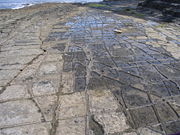
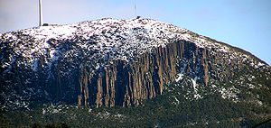
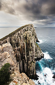
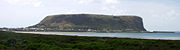
Tasmania has the largest exposure of dolerite in the world of 30000 km2 and a volume of 15000 km3. In Tasmania the rock is characteristic of many mountains with its columnar joining and dark blue grey colour. The composition is 40% plagioclase
, 20% clinopyroxene, 20% quartz, 5% ilmenite
and small percentages of potassium feldspar and amphibole
. The rock is altered by water to smectite and kaolinite
with quartz being left unaltered. The soil surface concentrates zirconium
and titanium
. The soils on dolerite also contain nodules of hematite
and may contain a buried layer of stones called a stone line.
Most of the intrusions are in the form of sills
up to 500 m thick. Mostly the sills are in the Parmeener Super Group rocks. There are also stepped sills, inclined sheets, cones and some dykes. Closely adjacent country rocks were metamorphosed to hornfels
. The upper parts of sills may be more coarsely grained. Dolerite is crushed to use as road metal, and aggregate.
Mount Anne, Mount Mueller, and Mount Wedge in the south west are capped in dolerite, where it also makes contact with Precambrian rocks.
It appears that the magma came from the crust rather than the mantle. Solidification occurred at .
A Jurassic forest was buried in an andestic volcanic eruption at Lune River. Here beneath the lava flow is mudstone with fossil wood and leaves.
On King Island, there was an intrusion of a biotite lamprophyre dyke at . Xenolith
s of granulite
-facies metamorphic rock resemble those found in eastern Antarctica.
continental breakup of Gondwana
started near Tasmania.
About a rift entered the east coast of Tasmania from the south and split off the Lord Howe Rise
. Sea floor spreading continued to move this continental sliver away to the east from Tasmania and Australia, and the rift jumped into the Lord Howe Rise and separated off the East Tasman Plateau. This East Tasman Plateau
microcontinent was originally off the southeast of Tasmania; it is a circular piece of continental rocks surrounded by oceanic crust. Volcanism occurred there .
In the Cretaceous Bass Strait was stretched and thinned and became filled with water. Vulcanism occurred in the Bass Basin. Flowering plants moved into Tasmania about .
At these times Tasmania was still connected to Antarctica with the southwest abutting Oates Land
and the Wilson Hills. South from Tasmania is an extension of continental crust called the South Tasman Rise
, The Gilbert Seamount was split from the South Tasman Rise by sea floor spreading about .
This extension created a number of sedimentary basins: Bass, Durroon, Gippsland, Otway and Sorell Basins. They each contain several kilometers of sediment from the late Mesozoic to Cainoozoic time periods. Bass Basin, between King Island, and north from the Tamar River, has up to 12 km of sediment, actually starting from the Jurassic. The lowest layer is the Otway Group of sandstone made from rock fragments. The Eastern View Coal
Measures follow. The Latrobe Group found in the Otway Basin, closer to Victoria, is from the same time and produces the oil found in the area. From Late Paleocene to early Eocene there was an unconformity. A shale from Demons Bluff Formation follows in the Eocene, deposited in calm sea water. The Torquay Group reaches from Oligocene to the current day, with marl
and limestone formed in open sea water.
The Durroon Basin is south east of the Bass Basin. Late Cretaceous rocks are conglomerate, with sandstones above. From there was a high thermal gradient of 55° per km. Around there was uplift and erosion of 900 m of sediment called Southern Ocean breakup
unconformity. A layer of olivine basalt lies on this, followed by carbonaceous shale for 300 m called Durroon Mudstone . This was deposited in a lake. Non marine sediment follow from Cretaceous, through Paleocene to Eocene . From the Demons Bluff
Formation sandstone formed, and finally the Torquay Group with more sandstone and shale than in the Bass Basin.
Rocks from the Cretaceous include syenite
porphyry sills and dykes near Cygnet around . They intrude the Lower Parmeener Group rocks, and dolerite. There are two kinds of composition, one is high alkali, alumina, silicon and barium containing melanite garnet
; the other is high in potassium with nepheline
and hauyne
. This rock is banatite. Clay from this was mined at Police point, and there are also some gold deposits. There is likely to be a giant laccolith
of syenite below Cygnet.
Cape Portland is host to andesite, lamprophyre and porphyrite intrusions and eruptions from . Musselroe Bay nearby has a lamprophyre and basalt from .
, but the Sorell Basin continued into the Oligocene
. Tertiary age deposits are found in the northern midlands (Tamar Graben), and south of Macquarie Harbour
in the Macquarie Harbour Graben. In the south east are the Derwent Graben and the Coal River Graben. Thick layers of Tertiary rocks are found in the estuary of the Derwent River, D'Entrecasteaux Channel
, Sandy Bay, Taroona, Middleton, Craigow Hill, and Spring Bay. The rocks are mostly silstone and clay. The deep estuary rocks are from the Paleocene
. Travertine
is found at Geilston Bay. Silcrete
and laterite
from this time is found too.
The Macquarie Harbour graben
deposits dating from Palaeocene and Eocene are poorly consolidated sand, and gravel, with some beds of lignite
and clay. Sediments are up to 500 meters thick, with the lowest layers consisting of dolerite boulders.
The Tamar Graben was an extension to the south of the Bass Basin onto the Tasmanian island. Sediments started in the graben at the very end of the Cretaceous, and into the Paleocene and Eocene with conglomerate, sandstone, mudstone and lignite. Basalt and conglomerate is buried south of White Hills. There is Eocene carbonaceous silt. The Longford Sub-basin extends inland south of the Tamar Graben, and is filled with 800 m of clay, sand and gravel, with some basalt towards the top layers, mostly from the Eocene.
The Devonport-Port Sorell Sub-Basin was formed in Paleocene with carbonaceous mudstone and sandstone. The Thirlstane Basalt is above at , an alkali-olivine basalt. Then the Wesley Vale Sand follows, and the Moriarty Basalt is 50 meters thick at .
The Sorell Basin forms the continental shelf
off the west coast. It has sub-basins of King Island, Sandy Cape, Strahan, and Port Davey which were formed in the Early Cretaceous. The King Island Basin is terminated on the east by a normal fault. It is south of King Island and north west of Tasmania. It has a basement of the Rocky Cape Group from the Proterozoic. The first sediments are red conglomerate beds for 190 m. mid-Upper Cretaceous sandstone and mudstone follow, the same age as the Sherbrook Group. Then more conglomerate sandstone and mudstone matching the Wangerrip Group up to early Eocene. Quartz sandstone is above this, with marl, mudstone and limestone from Oligocene and Miocene
age. There is an unconformity
at the Pliocene
base. Approximately 4 km of sediment is found in each subbasin.
just above sea level. The Scottsdale sub-basin is up to 225 meters thick from the late Oligocene to early Miocene.
 Volcanic vents opened up . Lava flows of basalt up to 20 meters thick were formed. Some volcanoes were explosive with bombs, and pyroclastic tuff
. The eruptions are probably from the Oligocene and Miocene. The earliest eruption was at Bream Creek on the east coast at . From Weldborough it is but mostly eroded.
In the south east, basalt from Sandy Bay dates from . Campania
has an alkali basalt from but it also has younger flows of olivine tholeiites. From near Hobart there is olivine basalt from .
In north east Tasmania, there are many lava flows from middle Eocene to early Miocene. There are at least four types: alkali olivine basalt, quartz tholeiite , alkaline basalt, and olivine nephelinite
. Lava flows in the north east flowed down valleys to the sea.
In the north west, there was so much lava that valleys filled and overflowed. A plain resulted with up to 750 meters thickness, and maximum extent south of Wynyard and Burnie. In the late Eocene and early Oligocene lakes were formed near Waratah
. Older alkaline basalt in the north west is from , at Table Cape basanite
from and at Stanley basanite is dated to and . Mount Cameron West has olivine basalt from 15.5 and 14.4 Ma.
On the southern part of the Central Plateau, there are olivine melilite
nephelinite, olivine nephelinite, quartz tholeiite lava flows. These ran south down tributaries of the Derwent River . On the east side of the Central Pateau an olivine nephelinite is from , and a flow of nepheline hawaiite
is from . In the western Midlands there is basalt from , and hawaiites from 25 and .
Around Launceston, igneous rocks were intruded into Tertiary sediments forming dolerite and monzonite.
 In the Ice age
there were valley glaciers and a 1000 km2 ice cap
.
Glaciation on Mount Field
occurred 41-44 ka during MIS 3, and 18 ka during MIS 2 with ice free conditions at 16 ka.
The ice cap on the Central Plateau
was around 65 km in diameter. Its western limit was the Du Cane Range
and Lake St Clair
. The central part under the ice cap was eroded. Significant areas of till are found in the central highlands arranged roughly in a circle around the former ice cap. Glaciers flowed out into the Franklin River
, the Canning Valley, and north into Forth and Mersey
Rivers.
Glaciers were in a number of locations on the west coast - at Mount Murchison
, Mount Tyndall and the Eldon Range
. Glaciers flowed into the Henty River and King River. Moraines were deposited at Crotty
and the Henty Road. Ice pushed out from the King River Glacier into Linda
, Comstock and Nelson Valleys. Wood from the Linda moraine had a carbon-14
age of 26480 years. There are also cirque
s on Frenchmans Cap, the West Coast Range, the Denison Range, and King William Range.
Several cave
s have developed in dolomite and limestone. Well known are King Solomons Cave and Marakoopa Cave at Mole Creek, and the Newdgate Cave at Hastings.
Periglacial
activity broke up rocks with ice wedge
s and formed block fields and block streams.
Gravels are also left from rivers in Quaternary times. These include the Huon River
with gravel at Randals Bay, Judbury and Beaupre Point. The pebbles are mostly quartzite, but include dolerite and agate
.
The film Walking with Dinosaurs
was filmed in part in central Tasmania where forests of gymnosperm
s similar to vegetation in the Cretaceous still grow.
 Macquarie Island
is politically part of the state of Tasmania, but comes from a very different geological context. It has formed as part of the oceanic crust
and mantle was buckled upwards. It is the only place in the world where a complete section of oceanic crust is exposed above water in the place it was formed. The rock composing the island was formed at the ridge
along the boundary of the Australian Plate and the Pacific Plate
in Eocene
times . Spreading from the ridge became less perpendicular (ESE-WNW), more oblique (SE-NW) and eventually almost parallel to the ridge (NNE-SSW). The plate boundary is now entirely a transform fault
a few kilometers to the west of the island. This left fracture zones and spreading fabric in the rock. The Geomagnetic reversals leave a magnetic anomaly
trace in the rock. Transpression on the plate boundary has deformed the oceanic crust in the vicinity to make the Macquarie Ridge Complex, raising Macquarie Island out of the water. It is studied to understand seafloor spreading
and transform faults, and hydrothermal alteration
of the undersea floor. Most of the south of the island consists of sub oceanic basalt layered between Globigerina ooze. The part north of Langdon Point and Ballast Bay consists of serpentinite
derived from gabbro, troctolite
, and peridotite
(dunite
, wehrlite, and harzburgite
). This was formed in the deep crust and mantle.
The two different rock zones are separated by the Finch-Langdon fault zone. It consists of seven segments of faults, subsidiary faults and splays. The fault is a transform fault with a corner at the spreading ridge. South of the fault on the west coast is breccia interbedded with the basalts. The breccia matrix is mud, and the stones consist of basalt, dolerite, and gabbro. The southern end of Bauer Bay has a talus
of breccia 140 m thick. On top is greywacke
and chert
. Many other faults cut the rock due to stress from the transform, and uplift. Some of these have scarps
that dam lakes.
Tasmania can be subdivided into two terranes, separated by the Tamar Fracture System, on a line from the Tamar River to Sorell in the south east. The West Tasmania Terrane constitutes most of the state, including all the Precambrian and Cambrian rocks. The East Tasmania Terrane makes up the north east and east coasts dating from the Ordovician.
(one of the largest earthquakes ever recorded) rocked the island, but caused little damage.
The last major earthquake in Tasmania was between magnitude 6.5 and 7 at the Lake Edgar Fault
in the Recent Period, but more than 200 years ago.
On 4 June 1872, a large landslip collapsed part of the side of Mount Arthur. A huge debris flow descended Humphrys Rivulet, stripping the upstream parts of trees and regolith. Where Glenorchy is now, a flood 600 meters wide engulfed farms. Broken trees, boulders, and mud were deposited. Remarkably no one lost their life as all escaped to safety when hearing the rumbling in the distance.
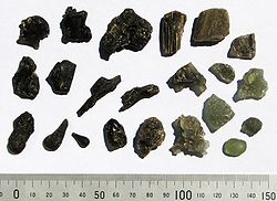
 Several unusual minerals are known from Tasmania: crocoite
, stichtite
, ferroaxinite from Dundas, sellaite
,
chondrodite
, norbergite, wagnerite
and fluoborite
from Mount Bischoff, heazlewoodite
(Originally discovered in Tasmania) and shandite
from the Trial Harbour nickel mine. From Mount Lyell there are rare minerals: mawsonite, betechtinite, florenceite, hessite
, jalpaite
, magnesiofoitite, svanbergite
-woodhousite, stannoidite
, stromeyerite
, and zunyite
.
Tasmanite
the mineral named after Tasmania is in Dana's classification as an Oxygenated hydrocarbon. It consists of reddish brown scales about 1 mm across. It is insoluble in benzene
, carbon disulfide
, turpentine
, ether or alcohol. It contains about 5% sulfur. It is found on the banks of the Mersey River. The shale it is present in, is a kind of oil shale
.
Pelionite is a name for cannel coal
from Mount Pelion East
and Barn Bluff
. This term is no longer used.
William Frederick Petterd was an amateur who studied minerals in Tasmania. He built up the Petterd collection which was donated to the Royal Society of Tasmania
and stored at the Tasmanian Museum and Art Gallery
. He discovered dundasite
, named from the mine where it was found. Dundaisite has formula PbAl2(CO3)2(OH)4.H2O. It is a silky milk white spherical aggregate.
Philipsbornite, PbAl3(AsO4)2(OH)5.H2O was originally found in the Adelaide mine and identified as a new mineral by Professor Walenta. It was named after another German professor Philipsborn. It occurs as several other mines and appears as a greenish grey earth.
Shandite
, Ni3Pb2S2, was first discovered at Trial Harbour by P. Ramdohr in 1960.
was measured at a gas seep in Smithton
as 26.4 degrees/km. Forest has 27.8 °/km. The Otway Basin has a gradient of 36°/km. Several companies are exploring for hot rocks for geothermal energy. The granite areas have a gradient of 30°/km, whereas the Parmeener sedimentary areas have a gradient of 40°/km. Heat flow is between 85 and 159 mW/m2.
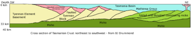 Active seismic exploration reveals the nature of the deep crust. It shows that the Tyennan block plumbs the depth to the moho
which is about 33 km underneath. The Tyennan Block slopes below the Adamsfield-Jubilee Element. Under the Tasmania Basin the block is stretched, with faults in to several large blocks that have tilted down. Above these the Adamsfield-Jubilee Element sediments have filled in the topography. Below the north east element the moho is 36 km deep with alternating seismically fast and slow rocks in the mid crust.
The Tyennan Block and the Rocky Cape Element have a boundary that dips at 30D to the east to the base of the crust. The Dundas Element lies on top of this boundary. A shallower Moho occurs under the Rocky Cape Block at 26 to 28 km. A deep segment is found under the central north of the state, down to 34 km. Bass Strait is a low seismic velocity zone.
Magnetic field measurements show that the different elements making up Tasmania have very different signatures. Wherever there is Jurassic Dolerite, the magnetic map shows fine ripples, so the Tasmania Basin stands out, as does the smaller intrusions in the other elements. The North east element is smooth, as is the Tyennan Block, and the Adamsfield-Jubilee Element. The Dundas Element has a smooth background with prominent north-south ridges. The Rocky Cape Element is densely packed with linear textures parallel to the Arthur Lineament, with the Smithton Syncline showing as a Y shape. King Island also shows north-south texture. Basalt south of Wynyard also shows a wrinkly magnetic signature.
The stress field in the crust has not yet been measured.
, Rosebery
, Zeehan, Que River, Henty
and Savage River. Many are hosted in the Mount Read Volcanics. They are in the form of massive sulfides. The Mount Lyell mine extracts copper and gold. The Renison Bell
mine was the largest primary tin producer in Australia. Mount Lyell gold and copper deposit was discovered in 1883, formerly the biggest copper mine, and operating till this day.
The Savage River ore body is in the Bowry Formation in the Arthur Metamorphic Complex. It consists of magnetite
, pyrite
, chalcopyrite
and tiny amounts of sphalerite
,
ilmenite
and rutile
. The ore was formed under the sea in association with volcanism. The Savage River area also contains deposits of Magnesite
in the form of marble.
At Beaconsfield
, gold
is mined from a quartz reef in a fault. The largest Tasmanian gold nugget
was found at Rocky River in 1883, weighing 243 ounces.
An oil exploration boom happened in the 1920s with two companies making bold claims, but earning nothing from oil shale
.
Asbestos
was mined from the Cape Sorell and Serpentine Hill ultramafic complexes.
A. W. Humphrey, a mineralogist, collected rocks and minerals from 1804. W. H. Twelvetrees
and W. F. Petterd did petrographic investigations in Cygnet, around 1899. Other unpaid people studied Tasmanian geology such as Paweł Edmund Strzelecki, Joseph Milligan who was a surgeon, Charles Darwin
, John Lhotsky
and Joseph Jukes
.
Joseph Milligan sent specimens of a manganese mineral from Frenchman's Cap and Galena
to the 1851 Great Exhibition in London. Small amounts of gold were discovered at Fingal
and Lefroy in 1851. William B. Clarke a geologist and Anglican parson predicted that gold would be found in Tasmania at 146 degrees east longitude line. In 17 July 1859 Charles Gould
a geologist recruited from England was appointed as the Geological Surveyor of Tasmania by the Tasmanian governor. He began the search for worthwhile minerals in the west, gave up and studied the geology of the eastern half of the state instead. He was commissioned by the Tasmanian Government in 1862 to return to the west coast
, he named mountains in the West Coast Range: Mount Lyell
after Charles Lyell
, Mount Darwin, Mount Huxley and opponents of Charles Darwin were commemorated with Mount Owen, Mount Sedgwick, and Mount Jukes. Gould returned several times but did not find worthwhile mineral deposits. James "Philosopher" Smith
discovered the Mount Bischoff tin deposit, the world's largest, on 4 December 1871. This discovery inspired Renison Bell to find more tin, and Dally found the gold reef at Beaconsfield and at Lefroy.
In 1882, Gustav Thureau was appointed Inspector of Mines, later called Inspector and Mining Geologist. In 1889, the position became Geological Surveyor. William Harper Twelvetrees
took up the position. He established the Geological Survey library, and mineral and rock collection at the Queen Victoria Museum in Launceston. In 1883, the Mines Office was created from the Commissioners and registrars for mines and goldfields that worked in the Mines Branch of the Lands and Works Department. Bernard Shaw was appointed the Secretary for Mines. The Mines Office gained a Minister for Mines in 1894 and changed its name to Mines Department. Bernard Shaw later became the Police Commissioner. The Mines Department lost its separate existence in July 1989 when it was merged to the Department of Resources and Energy, which has since changed its name several times. The current name for the Mines Office is Mineral Resources Tasmania.
Tannatt William Edgeworth David a geologist working out of Sydney was a proponent of the idea of Permo-Carboniferous glaciations. He studied the evidence for past glaciations in Tasmania.
 Professor S. Warren Carey established the Department of Geology at the University of Tasmania
in 27 October 1946. He was an early proponent of continental drift and the unauthodox expanding earth theory. He had become the Government Geologist of Tasmania in 1944 where he organised the understanding of Paleozoic formations in the west coast mineral fields, and introduced the Cenozoic rift valley idea, and the policy of publishing the results of the Geologic Survey. Carey introduced terms such as orocline and sphenochasm and the concept of the hotspot
. The University of Tasmania building for Geology and Geography was constructed in 1962. It had exhibitions of a Foucault pendulum
, a seismometer
recording drum, a mosaic illustrating crystal symmetry, and a large terrestrial globe. Carey organised and hosted the Continental Drift Symposium in 1956.
The Tasmanian Seismic Net was established in 1957.
Professor Carey founded the Tasmanian Caverneering Club.
Tasmania
Tasmania is an Australian island and state. It is south of the continent, separated by Bass Strait. The state includes the island of Tasmania—the 26th largest island in the world—and the surrounding islands. The state has a population of 507,626 , of whom almost half reside in the greater Hobart...
has a complex geological history, with the world's biggest exposure of diabase, or dolerite
Diabase
Diabase or dolerite is a mafic, holocrystalline, subvolcanic rock equivalent to volcanic basalt or plutonic gabbro. In North American usage, the term diabase refers to the fresh rock, whilst elsewhere the term dolerite is used for the fresh rock and diabase refers to altered material...
. The rock record contains representatives of each period of the Neoproterozoic
Neoproterozoic
The Neoproterozoic Era is the unit of geologic time from 1,000 to 542.0 ± 1.0 million years ago. The terminal Era of the formal Proterozoic Eon , it is further subdivided into the Tonian, Cryogenian, and Ediacaran Periods...
, Paleozoic
Paleozoic
The Paleozoic era is the earliest of three geologic eras of the Phanerozoic eon, spanning from roughly...
, Mesozoic
Mesozoic
The Mesozoic era is an interval of geological time from about 250 million years ago to about 65 million years ago. It is often referred to as the age of reptiles because reptiles, namely dinosaurs, were the dominant terrestrial and marine vertebrates of the time...
and Cainozoic eras. It is one of the few southern hemisphere areas glaciated during the Pleistocene
Pleistocene
The Pleistocene is the epoch from 2,588,000 to 11,700 years BP that spans the world's recent period of repeated glaciations. The name pleistocene is derived from the Greek and ....
with glacial landforms in the higher parts. The west coast region hosts significant mineralisation and numerous active and historic mines.
Geological history
The earliest geological history is recorded in rocks from over . These older rocks from western Tasmania and King Island were strongly folded and metamorphosed into rocks such as quartziteQuartzite
Quartzite is a hard metamorphic rock which was originally sandstone. Sandstone is converted into quartzite through heating and pressure usually related to tectonic compression within orogenic belts. Pure quartzite is usually white to gray, though quartzites often occur in various shades of pink...
. After this there are many signs of glaciation from the Cryogenian
Cryogenian
The Cryogenian is a geologic period that lasted from . It forms the second geologic period of the Neoproterozoic Era, preceded by the Tonian Period and followed by the Ediacaran...
, as well as the global warming
Global warming
Global warming refers to the rising average temperature of Earth's atmosphere and oceans and its projected continuation. In the last 100 years, Earth's average surface temperature increased by about with about two thirds of the increase occurring over just the last three decades...
that occurred at the start of the Ediacaran
Ediacaran
The Ediacaran Period , named after the Ediacara Hills of South Australia, is the last geological period of the Neoproterozoic Era and of the Proterozoic Eon, immediately preceding the Cambrian Period, the first period of the Paleozoic Era and of the Phanerozoic Eon...
period. An orogeny
Orogeny
Orogeny refers to forces and events leading to a severe structural deformation of the Earth's crust due to the engagement of tectonic plates. Response to such engagement results in the formation of long tracts of highly deformed rock called orogens or orogenic belts...
folded the older Precambrian
Precambrian
The Precambrian is the name which describes the large span of time in Earth's history before the current Phanerozoic Eon, and is a Supereon divided into several eons of the geologic time scale...
rocks. In the Cambrian
Cambrian
The Cambrian is the first geological period of the Paleozoic Era, lasting from Mya ; it is succeeded by the Ordovician. Its subdivisions, and indeed its base, are somewhat in flux. The period was established by Adam Sedgwick, who named it after Cambria, the Latin name for Wales, where Britain's...
time the Tyennan block forming the south west
South West Tasmania
South West Tasmania is a region in Tasmania that has evolved over the fifty years between its consideration as a potential resource for development to its consideration as World Heritage wilderness...
and central Tasmania, was pushed up and slightly over the land of north west Tasmania, the Tyennan Orogeny. Then there were volcanic action and sediments from the Cambrian and Ordovician
Ordovician
The Ordovician is a geologic period and system, the second of six of the Paleozoic Era, and covers the time between 488.3±1.7 to 443.7±1.5 million years ago . It follows the Cambrian Period and is followed by the Silurian Period...
. The large ore deposits were formed on the West Coast
West Coast, Tasmania
The West Coast of Tasmania is the part of the state that is strongly associated with wilderness, mining and tourism, rough country and isolation...
. The north east of Tasmania began to form as part of the Lachlan Orogen with turbidity flows of mud and sand on to the ocean floor. In the Devonian the Taberabban Orogeny caused more folding, and intrusion of granite
Granite
Granite is a common and widely occurring type of intrusive, felsic, igneous rock. Granite usually has a medium- to coarse-grained texture. Occasionally some individual crystals are larger than the groundmass, in which case the texture is known as porphyritic. A granitic rock with a porphyritic...
on the west and east coasts, and probably joined the east of Tasmania to the west.
In the Permian
Permian
The PermianThe term "Permian" was introduced into geology in 1841 by Sir Sir R. I. Murchison, president of the Geological Society of London, who identified typical strata in extensive Russian explorations undertaken with Edouard de Verneuil; Murchison asserted in 1841 that he named his "Permian...
period, conditions were again glacial and the Tasmania basin formed, with low sea levels in the Triassic
Triassic
The Triassic is a geologic period and system that extends from about 250 to 200 Mya . As the first period of the Mesozoic Era, the Triassic follows the Permian and is followed by the Jurassic. Both the start and end of the Triassic are marked by major extinction events...
. A giant intrusion of magma happened in the Jurassic
Jurassic
The Jurassic is a geologic period and system that extends from about Mya to Mya, that is, from the end of the Triassic to the beginning of the Cretaceous. The Jurassic constitutes the middle period of the Mesozoic era, also known as the age of reptiles. The start of the period is marked by...
forming diabase
Diabase
Diabase or dolerite is a mafic, holocrystalline, subvolcanic rock equivalent to volcanic basalt or plutonic gabbro. In North American usage, the term diabase refers to the fresh rock, whilst elsewhere the term dolerite is used for the fresh rock and diabase refers to altered material...
, or dolerite which gives many of the Tasmanian mountains their characteristic appearance. Continental breakup happened in the Cretaceous
Cretaceous
The Cretaceous , derived from the Latin "creta" , usually abbreviated K for its German translation Kreide , is a geologic period and system from circa to million years ago. In the geologic timescale, the Cretaceous follows the Jurassic period and is followed by the Paleogene period of the...
and Tertiary
Tertiary
The Tertiary is a deprecated term for a geologic period 65 million to 2.6 million years ago. The Tertiary covered the time span between the superseded Secondary period and the Quaternary...
Periods, splitting off undersea plateaus, forming Bass Strait
Bass Strait
Bass Strait is a sea strait separating Tasmania from the south of the Australian mainland, specifically the state of Victoria.-Extent:The International Hydrographic Organization defines the limits of the Bass Strait as follows:...
and ultimately breaking Tasmania away from Antarctica. In the Tertiary, a couple of basins extended inland from Macquarie Harbour
Macquarie Harbour
Macquarie Harbour is a large, shallow, but navigable by shallow draft vessels inlet on the West Coast of Tasmania, Australia.-History:James Kelly wrote in his narrative "First Discovery of Port Davey and Macquarie Harbour" how he sailed from Hobart in a small open five-oared whaleboat to discover...
and the northern Midlands. The higher mountains were glaciated during the Pleistocene
Pleistocene
The Pleistocene is the epoch from 2,588,000 to 11,700 years BP that spans the world's recent period of repeated glaciations. The name pleistocene is derived from the Greek and ....
.
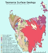
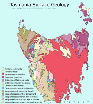
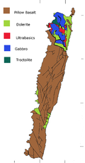
Precambrian
The oldest rocks in Tasmania from the Precambrian form several blocks. The blocks are King Island; Rocky Cape in the North West, Dundas Element in the mid west; Sheffield Element in the central north; Tyennan Element in the west central and south west; and the Adamsfield-Jubilee Element in the south central to south coast.Basalt
Basalt is a common extrusive volcanic rock. It is usually grey to black and fine-grained due to rapid cooling of lava at the surface of a planet. It may be porphyritic containing larger crystals in a fine matrix, or vesicular, or frothy scoria. Unweathered basalt is black or grey...
s that have been metamorphosed by amphibolite
Amphibolite
Amphibolite is the name given to a rock consisting mainly of hornblende amphibole, the use of the term being restricted, however, to metamorphic rocks. The modern terminology for a holocrystalline plutonic igneous rocks composed primarily of hornblende amphibole is a hornblendite, which are...
grade metamorphism at . Sedimentary rocks such as feldspathic sandstone that have been altered to schist
Schist
The schists constitute a group of medium-grade metamorphic rocks, chiefly notable for the preponderance of lamellar minerals such as micas, chlorite, talc, hornblende, graphite, and others. Quartz often occurs in drawn-out grains to such an extent that a particular form called quartz schist is...
and quartzite. A dolerite sill
Sill (geology)
In geology, a sill is a tabular sheet intrusion that has intruded between older layers of sedimentary rock, beds of volcanic lava or tuff, or even along the direction of foliation in metamorphic rock. The term sill is synonymous with concordant intrusive sheet...
was intruded. Granite intruded in the Cryogenian. The granite contains inherited zircon
Zircon
Zircon is a mineral belonging to the group of nesosilicates. Its chemical name is zirconium silicate and its corresponding chemical formula is ZrSiO4. A common empirical formula showing some of the range of substitution in zircon is 1–x4x–y...
s from . The Wickham deformation affected the earlier rocks by heating to 470 to 480 °C at pressures below 300 MPa
MPA
-Academic degrees:* Master of Professional Accountancy* Master of Public Administration* Master of Public Affairs* Master of Physician's Assistant-Chemicals:* Medroxyprogesterone acetate, also known by the brand name Depo-Provera* Morpholide of pelargonic acid...
, and tight folding
Fold (geology)
The term fold is used in geology when one or a stack of originally flat and planar surfaces, such as sedimentary strata, are bent or curved as a result of permanent deformation. Synsedimentary folds are those due to slumping of sedimentary material before it is lithified. Folds in rocks vary in...
. This was followed later in the Neoproterozoic
Neoproterozoic
The Neoproterozoic Era is the unit of geologic time from 1,000 to 542.0 ± 1.0 million years ago. The terminal Era of the formal Proterozoic Eon , it is further subdivided into the Tonian, Cryogenian, and Ediacaran Periods...
on the eastern side of the island with beds of diamictite
Diamictite
Diamictite : through and µεικτός : mixed) is a poorly or non-sorted conglomerate or breccia with a wide range of clasts, up to 25% of them gravel sized...
, dolomite
Dolomite
Dolomite is a carbonate mineral composed of calcium magnesium carbonate CaMg2. The term is also used to describe the sedimentary carbonate rock dolostone....
, mudstone
Mudstone
Mudstone is a fine grained sedimentary rock whose original constituents were clays or muds. Grain size is up to 0.0625 mm with individual grains too small to be distinguished without a microscope. With increased pressure over time the platey clay minerals may become aligned, with the...
, tholeiite
Tholeiite
The tholeiitic magma series is one of two main magma series in igneous rocks, the other magma series being the calc–alkaline. A magma series is a series of compositions that describes the evolution of a mafic magma, which is high in magnesium and iron and produces basalt or gabbro, as it...
, and picrite interleaved with conglomerate
Conglomerate (geology)
A conglomerate is a rock consisting of individual clasts within a finer-grained matrix that have become cemented together. Conglomerates are sedimentary rocks consisting of rounded fragments and are thus differentiated from breccias, which consist of angular clasts...
. Also dykes
Dike (geology)
A dike or dyke in geology is a type of sheet intrusion referring to any geologic body that cuts discordantly across* planar wall rock structures, such as bedding or foliation...
of augite
Augite
Augite is a single chain inosilicate mineral, 2O6. The crystals are monoclinic and prismatic. Augite has two prominent cleavages, meeting at angles near 90 degrees.-Characteristics:Augite is a solid solution in the pyroxene group...
syenite
Syenite
Syenite is a coarse-grained intrusive igneous rock of the same general composition as granite but with the quartz either absent or present in relatively small amounts Syenite is a coarse-grained intrusive igneous rock of the same general composition as granite but with the quartz either absent or...
, picrite and tholeiite dolerite were intruded. An interpretation is that deposits occurred in a tidal area, with a continental
Continental crust
The continental crust is the layer of igneous, sedimentary, and metamorphic rocks which form the continents and the areas of shallow seabed close to their shores, known as continental shelves. This layer is sometimes called sial due to more felsic, or granitic, bulk composition, which lies in...
rift
Rift
In geology, a rift or chasm is a place where the Earth's crust and lithosphere are being pulled apart and is an example of extensional tectonics....
allowing magma
Magma
Magma is a mixture of molten rock, volatiles and solids that is found beneath the surface of the Earth, and is expected to exist on other terrestrial planets. Besides molten rock, magma may also contain suspended crystals and dissolved gas and sometimes also gas bubbles. Magma often collects in...
from the mantle
Mantle (geology)
The mantle is a part of a terrestrial planet or other rocky body large enough to have differentiation by density. The interior of the Earth, similar to the other terrestrial planets, is chemically divided into layers. The mantle is a highly viscous layer between the crust and the outer core....
to intrude. These newer Proterozoic sediments were then tilted and faulted.
In the Rocky Cape Block west of Wynyard
Wynyard, Tasmania
Wynyard is a rural town on the north-west coast of Tasmania, Australia. It lies west of Burnie on the Bass Highway at the mouth of the Inglis River....
and north of Granville Harbour, the Precambrian rocks consist of the Rocky Cape group from the Stenian
Stenian
The Stenian is the final geologic period in the Mesoproterozoic Era and lasted from 1200 Mya to 1000 Mya . Instead of being based on stratigraphy, these dates are defined chronometrically...
period, with Cowrie Siltstone
Siltstone
Siltstone is a sedimentary rock which has a grain size in the silt range, finer than sandstone and coarser than claystones.- Description :As its name implies, it is primarily composed of silt sized particles, defined as grains 1/16 - 1/256 mm or 4 to 8 on the Krumbein phi scale...
, Detention Subgroup, Irby Siltstone, and Jacob Quartzite. The sequence covers most of the element and is over 5700 meters thick. Currents travelled either northwesterly or southeasterly. The metamorphic belt titled the Arthur Lineament forms the limits of the Rocky Cape Group to the south east. The Burnie Formation followed in the Tonian
Tonian
The Tonian is the first geologic period in the Neoproterozoic Era and lasted from 1000 Mya to 850 Mya...
period south east of the lineament with greywacke
Greywacke
Greywacke or Graywacke is a variety of sandstone generally characterized by its hardness, dark color, and poorly sorted angular grains of quartz, feldspar, and small rock fragments or lithic fragments set in a compact, clay-fine matrix. It is a texturally immature sedimentary rock generally found...
and slaty mudstone, and also some basic pillow lava
Pillow lava
Pillow lavas are lavas that contain characteristic pillow-shaped structures that are attributed to the extrusion of the lava under water, or subaqueous extrusion. Pillow lavas in volcanic rock are characterized by thick sequences of discontinuous pillow-shaped masses, commonly up to one metre in...
s. The Oonah Formation has even more varieties of rock than the Burnie formation, also including conglomerate, quartz sandstone, dolomite and chert
Chert
Chert is a fine-grained silica-rich microcrystalline, cryptocrystalline or microfibrous sedimentary rock that may contain small fossils. It varies greatly in color , but most often manifests as gray, brown, grayish brown and light green to rusty red; its color is an expression of trace elements...
. The Bowry Formation in the Cryogenian was intruded by granite (Bowry granitoids) . These have been metamorphosed to the blueschist
Blueschist
Blueschist is a rock that forms by the metamorphism of basalt and rocks with similar composition at high pressures and low temperatures, approximately corresponding to a depth of 15 to 30 kilometers and 200 to ~500 degrees Celsius....
level. In the Smithton Synclinorium the Togari Group followed with conglomerate from the Sturtian and Marinoan glaciation
Marinoan glaciation
The Marinoan glaciation was a period of worldwide glaciation that lasted from approximately 650 to 635 Ma during the Cryogenian period. The glaciation may have covered the entire planet, in an event called the Snowball Earth...
s and dolomite marking the end of Cryogenian and on into the Ediacaran and Cambrian. The Togari group contains greywacke, conglomerate, diamictite, mafic volcanic rocks, and quartz sandstone, and mudstone. The components of the Togari Group are called Forest Conglomerate and Quartzite, Black River Dolomite, Kanunnah subgroup (containing the lavas) and Smithton Dolomite. These rocks are important for determining the boundary between the Cryogenian and Ediacaran periods as they contain volcanics that can be dated and dolostones marking the end of glaciations and marking the period boundary.
Near Corinna
Corinna
Corinna or Korinna was an Ancient Greek poet, traditionally attributed to the 6th century BC. According to ancient sources such as Plutarch and Pausanias, she came from Tanagra in Boeotia, where she was a teacher and rival to the better-known Theban poet Pindar...
the Ahrberg group is correlated with the Togari Group and the Success Creek Group. It contains Donaldson Formation (a marine fan), Savage Dolomite which contains stromatolite
Stromatolite
Stromatolites or stromatoliths are layered accretionary structures formed in shallow water by the trapping, binding and cementation of sedimentary grains by biofilms of microorganisms, especially cyanobacteria ....
s; Bernafai Volcanics containing albite
Albite
Albite is a plagioclase feldspar mineral. It is the sodium endmember of the plagioclase solid solution series. As such it represents a plagioclase with less than 10% anorthite content. The pure albite endmember has the formula NaAlSi3O8. It is a tectosilicate. Its color is usually pure white, hence...
epidote
Epidote
Epidote is a calcium aluminium iron sorosilicate mineral, Ca2Al2O, crystallizing in the monoclinic system. Well-developed crystals are of frequent occurrence: they are commonly prismatic in habit, the direction of elongation being perpendicular to the single plane of symmetry. The faces are often...
actinolite
Actinolite
Actinolite is an amphibole silicate mineral with the chemical formula .-Etymology:The name actinolite is derived from the Greek word aktis , meaning "beam" or "ray", because of the mineral's fibrous nature...
chlorite
Chlorite group
The chlorites are a group of phyllosilicate minerals. Chlorites can be described by the following four endmembers based on their chemistry via substitution of the following four elements in the silicate lattice; Mg, Fe, Ni, and Mn....
; Corinna Dolomite, and Tunnelrace Volcanics. Where the dolomite has been dissolved away over million of years it has left layers of very pure silica flour, an important mineral resource.
The Dundas Element lowest level starts with the Oonah Formation with greywacke, dolomite and basic volcanics. The Oonah Formation appeared between . It has three sections, Mount Bischoff Inlier
Inliers and outliers (geology)
An inlier is an area of older rocks surrounded by younger rocks. Inliers are typically formed by the erosion of overlying younger rocks to reveal a limited exposure of the older underlying rocks. Faulting or folding may also contribute to the observed outcrop pattern...
, the Ramsay River Inlier and the Dundas Inlier. The Success Creek Group from the Cryogenian has diamictite, quartz sandstone (Dalcoath Formation), and mudstone. It includes the Renison Bell Formation named after the Renison Bell
Renison Bell
Renison Bell is an underground tin mine and locality on the West Coast of Tasmania, Australia.-History:In 1890 tin-bearing gossan was found near Argent River by George Renison Bell...
mine. The red rock member is hematite
Hematite
Hematite, also spelled as haematite, is the mineral form of iron oxide , one of several iron oxides. Hematite crystallizes in the rhombohedral system, and it has the same crystal structure as ilmenite and corundum...
stained chert. The sediments slumped while soft forming folds and breccia
Breccia
Breccia is a rock composed of broken fragments of minerals or rock cemented together by a fine-grained matrix, that can be either similar to or different from the composition of the fragments....
and mélange
Mélange
In geology, a mélange is a large-scale breccia, a mappable body of rock characterized by a lack of continuous bedding and the inclusion of fragments of rock of all sizes, contained in a fine-grained deformed matrix. The mélange typically consists of a jumble of large blocks of varied lithologies...
. They were then capped with limestone
Limestone
Limestone is a sedimentary rock composed largely of the minerals calcite and aragonite, which are different crystal forms of calcium carbonate . Many limestones are composed from skeletal fragments of marine organisms such as coral or foraminifera....
. The group is up to 1000 meters thick. The Crimson Creek Formation consists of greywacke with tholeiitic basalt. It is from 4000 to 5000 meters thick. This formation could be as late as the early Cambrian. The basalt is probably the same as mafic lavas of the Kanunnah Subgroup.
The Sheffield Element extends from Wynyard past Devonport
Devonport, Tasmania
-Sport:The Devonport Football Club is an Australian Rules team competing in the Tasmanian Statewide League. The Devonport Rugby Club is a Rugby Union team competing in the Tasmanian Rugby Union Statewide League...
and the Asbestos Range on the north coast and as far south east as Golden Valley. It contains structural elements called Dial Range Trough, Forth Massif, Fossey Mountains Trough. The oldest Precambrian rocks are the Ulverstone Metamorphic Complex and Forth Metamorphic Complex. This is assumed to be the same age as metamorphic rocks from the Tyennan Block, at from the Stenian
Stenian
The Stenian is the final geologic period in the Mesoproterozoic Era and lasted from 1200 Mya to 1000 Mya . Instead of being based on stratigraphy, these dates are defined chronometrically...
. This contains zircons predominately dated , but also from 1710, 1851, the oldest being , and the youngest . The Burnie or Oonah Formation with Greywacke is possibly from the Tonian period, dated around . Slate from both the Burnie and Oonah formations is dated at . Both of these formations came from a shallow marine shelf. The Cooee Dolerite intruded the Burnie Formation at . Zircon grains in the Cooee Dolerite are from mostly .
The Barrington Chert is finely laminated and has flaggy bedding. It is found in the Dial Range and Fossey Mountain Troughs, up to 1 km thick. The Motton Spilite lies on top of the chert. It consists of pillow lava, massive lava flows, sediments made from volcanic fragments, and chert breccia. The basalt is an ocean floor type. The Badger Head Inlier consists of deformed Burnie Formation. The Andersons Creek Ultramafic Complex is west of Beaconsfield
Beaconsfield, Tasmania
Beaconsfield is a town near the Tamar River, in the north-east of Tasmania, Australia. It lies 40 kilometres north of Launceston on the West Tamar Highway. It is part of the Municipality of West Tamar...
and east of the inlier with serpentinite
Serpentinite
Serpentinite is a rock composed of one or more serpentine group minerals. Minerals in this group are formed by serpentinization, a hydration and metamorphic transformation of ultramafic rock from the Earth's mantle...
, pyroxenite
Pyroxenite
Pyroxenite is an ultramafic igneous rock consisting essentially of minerals of the pyroxene group, such as augite and diopside, hypersthene, bronzite or enstatite. They are classified into clinopyroxenites, orthopyroxenites, and the websterites which contain both pyroxenes...
, gabbro
Gabbro
Gabbro refers to a large group of dark, coarse-grained, intrusive mafic igneous rocks chemically equivalent to basalt. The rocks are plutonic, formed when molten magma is trapped beneath the Earth's surface and cools into a crystalline mass....
and a sliver of oolitic
Oolite
Oolite is a sedimentary rock formed from ooids, spherical grains composed of concentric layers. The name derives from the Hellenic word òoion for egg. Strictly, oolites consist of ooids of diameter 0.25–2 mm; rocks composed of ooids larger than 2 mm are called pisolites...
chert introduced as a fault bounded block. To the west of the Badger Head Inlier is the Port Sorell Formation, a tectonic mélange of marine sediments and dolerite.
Turbidite
Turbidite geological formations have their origins in turbidity current deposits, which are deposits from a form of underwater avalanche that are responsible for distributing vast amounts of clastic sediment into the deep ocean.-The ideal turbidite sequence:...
with quartz sandstone
Sandstone
Sandstone is a sedimentary rock composed mainly of sand-sized minerals or rock grains.Most sandstone is composed of quartz and/or feldspar because these are the most common minerals in the Earth's crust. Like sand, sandstone may be any colour, but the most common colours are tan, brown, yellow,...
interbedded with siltstone deposited by gravity flows. This has been deformed with tight folds that have been overturned, and exhibits crenulation cleavage
Cleavage (geology)
This article is about rock cleavage, for cleavage in minerals see Cleavage Cleavage, in structural geology and petrology, describes a type of planar rock feature that develops as a result of deformation and metamorphism. The degree of deformation and metamorphism along with rock type determines the...
and brittle faulting. Zircons in the quartzite have peak numbers aged and . Secondly, the Scotchfire Metamorphic Complex contains quartzite deposited in the sea from windblown desert sands, schist
Schist
The schists constitute a group of medium-grade metamorphic rocks, chiefly notable for the preponderance of lamellar minerals such as micas, chlorite, talc, hornblende, graphite, and others. Quartz often occurs in drawn-out grains to such an extent that a particular form called quartz schist is...
and phyllite
Phyllite
Phyllite is a type of foliated metamorphic rock primarily composed of quartz, sericite mica, and chlorite; the rock represents a gradation in the degree of metamorphism between slate and mica schist. Minute crystals of graphite, sericite, or chlorite impart a silky, sometimes golden sheen to the...
possibly from a delta. Small quantities of dolomite and boulder conglomerate
Conglomerate (geology)
A conglomerate is a rock consisting of individual clasts within a finer-grained matrix that have become cemented together. Conglomerates are sedimentary rocks consisting of rounded fragments and are thus differentiated from breccias, which consist of angular clasts...
are also included. The complex includes boudinage structure
Boudinage
thumb|Boudinaged quartz vein in shear foliation, Starlight Pit, Fortnum Gold Mine, Western Australia.Boudinage is a geological term for structures formed by extension, where a rigid tabular body such as a bed of sandstone, is stretched and deformed amidst less competent surroundings...
and en echelon veins
Vein (geology)
In geology, a vein is a distinct sheetlike body of crystallized minerals within a rock. Veins form when mineral constituents carried by an aqueous solution within the rock mass are deposited through precipitation...
. Phyllite
near Strathgordon
Strathgordon, Tasmania
Strathgordon is a locality in Tasmania, Australia at the end of the Gordon River Road, the most south westerly road in the south west of Tasmania.It is remote by Tasmanian standards with the nearest basic services away along a winding road at Maydena....
has been dated at . Metamorphism to greenschist facies occurred at around 400° and 300MPa. The Franklin Metamorphic Complex is near Mount Franklin. At Raglan Range the rocks are a mixture of quartzite and knotted schist
Schist
The schists constitute a group of medium-grade metamorphic rocks, chiefly notable for the preponderance of lamellar minerals such as micas, chlorite, talc, hornblende, graphite, and others. Quartz often occurs in drawn-out grains to such an extent that a particular form called quartz schist is...
. Metamorphism in this area was higher grade with almandine
Almandine
Almandine , also known incorrectly as almandite, is a species of mineral belonging to the garnet Group. The name is a corruption of alabandicus, which is the name applied by Pliny the Elder to a stone found or worked at Alabanda, a town in Caria in Asia Minor. Almandine is an iron alumina garnet,...
garnet
Garnet
The garnet group includes a group of minerals that have been used since the Bronze Age as gemstones and abrasives. The name "garnet" may come from either the Middle English word gernet meaning 'dark red', or the Latin granatus , possibly a reference to the Punica granatum , a plant with red seeds...
forming. The Collingwood area experienced the highest grade of metamorphism with garnet-mica schist, mica schist and garnet-mica-kyanite
Kyanite
Kyanite, whose name derives from the Greek word kuanos sometimes referred to as "kyanos", meaning deep blue, is a typically blue silicate mineral, commonly found in aluminium-rich metamorphic pegmatites and/or sedimentary rock. Kyanite in metamorphic rocks generally indicates pressures higher than...
gneiss
Gneiss
Gneiss is a common and widely distributed type of rock formed by high-grade regional metamorphic processes from pre-existing formations that were originally either igneous or sedimentary rocks.-Etymology:...
present, and enough heat to form veins of migmatite
Migmatite
Migmatite is a rock at the frontier between igneous and metamorphic rocks. They can also be known as diatexite.Migmatites form under extreme temperature conditions during prograde metamorphism, where partial melting occurs in pre-existing rocks. Migmatites are not crystallized from a totally...
. Eclogite
Eclogite
Eclogite is a mafic metamorphic rock. Eclogite is of special interest for at least two reasons. First, it forms at pressures greater than those typical of the crust of the Earth...
and garnet amphibolite are believed to be the remains of basalt. The eclogite has been heated to 700° at 1520 MPa, a burial depth of perhaps 50 km. Metamorphism happened at the same time as the Cambrian ultramafic complexes were introduced.
In the Neoproterozoic in the Jane River basin, the very thick Jane River Dolomite appeared.
The Adamsfield Jubilee element is east of the Tyennan Block. It has a strip exposed on the surface that includes the Florentine Synclinorium, The Adamsfield District, the Jubilee Region, and down to the South Coast at Precipitous Bluff and Surprise Bay. It also underlies the Tasmania Basin across southeastern Tasmania, but not including the east coast. The subsurface structure has been studied from a few outliers, boreholes, xenolith
Xenolith
A xenolith is a rock fragment which becomes enveloped in a larger rock during the latter's development and hardening. In geology, the term xenolith is almost exclusively used to describe inclusions in igneous rock during magma emplacement and eruption...
s, and gravity and magnetic surveys. The basement at 5 km deep is the same as the Tyennan metamorphic rocks (Scotchfire Metamorphic Complex). Its oldest exposed rocks are from the Clark Group, of pelitic rocks, some with stromatolites, and evaporite
Evaporite
Evaporite is a name for a water-soluble mineral sediment that result from concentration and crystallization by evaporation from an aqueous solution. There are two types of evaporate deposits, marine which can also be described as ocean deposits, and non-marine which are found in standing bodies of...
s, and overlaid with orthoquartzite. The Weld River Group lies above, starting with 0.5 km thickness of conglomerate and sandstone, then up to 3 km of dolostone
Dolostone
Dolostone or dolomite rock is a sedimentary carbonate rock that contains a high percentage of the mineral dolomite. In old U.S.G.S. publications it was referred to as magnesian limestone. Most dolostone formed as a magnesium replacement of limestone or lime mud prior to lithification. It is...
, interbedded with sandstone, mudstone and diamictite. Glacial dropstones are found in the interbedding, suggesting Cryogenian age, however carbon isotope results suggest Ediacaran age instead. Gravity and magnetic studies indicate that this sort of dolomite (dense and non-magnetic) underlies Hobart and Bruny Island in a north south strip, and also in a region west of Hobart.
The Cape Sorell Block is a region of metamorphosed sediments from the Mesoproterozoic
Mesoproterozoic
The Mesoproterozoic Era is a geologic era that occurred between 1600 Ma and 1000 Ma . The Mesoproterozoic was the first period of Earth's history with a respectable geological record. Continents existed in the Paleoproterozoic, but we know little about them...
, to the south of the west end of Macquarie Harbour. It is separated from Neoproterozoic
Neoproterozoic
The Neoproterozoic Era is the unit of geologic time from 1,000 to 542.0 ± 1.0 million years ago. The terminal Era of the formal Proterozoic Eon , it is further subdivided into the Tonian, Cryogenian, and Ediacaran Periods...
rocks by a low angle thrust fault
Thrust fault
A thrust fault is a type of fault, or break in the Earth's crust across which there has been relative movement, in which rocks of lower stratigraphic position are pushed up and over higher strata. They are often recognized because they place older rocks above younger...
. The Neoproterozoic rocks contain greywacke, mudstone and pillow lavas of the Lucas Creek Volcanics (matching the Crimson
Creek Formation), mudstone, siltstone (matching the Success Creek Group) and dolomite (correlating with the Togari Group). South east of this is a metamorphosed belt of dolomite rich sediments correlated with the Oonah Formation. An ultramafic belt called Point Hibbs Mélange reaches the coast near Point Hibbs. This has been complexly faulted with Cambrian, Ordovician
Ordovician
The Ordovician is a geologic period and system, the second of six of the Paleozoic Era, and covers the time between 488.3±1.7 to 443.7±1.5 million years ago . It follows the Cambrian Period and is followed by the Silurian Period...
and Devonian
Devonian
The Devonian is a geologic period and system of the Paleozoic Era spanning from the end of the Silurian Period, about 416.0 ± 2.8 Mya , to the beginning of the Carboniferous Period, about 359.2 ± 2.5 Mya...
sediments and limestone.
At the end of the Precambrian uplift there were several raised blocks forming land above the sea: the Tyennan Uplift in the central and south west Tasmania, the Rocky Cape uplift in the north west, and the Forth uplift, near Forth in the north. The far north west also had uplift as probably also did some region to the east. Basins formed were the Smithton Basin, Dial Range Basin, Fossey Mountain Basin and the Adamsfield Basin.
Early Cambrian
Next an oceanic arcVolcanic arc
A volcanic arc is a chain of volcanoes positioned in an arc shape as seen from above. Offshore volcanoes form islands, resulting in a volcanic island arc. Generally they result from the subduction of an oceanic tectonic plate under another tectonic plate, and often parallel an oceanic trench...
collided with eastern Australia. This resulted in deep oceanic crust being thrust in a sheet over the top of the Precambrian rocks. This has left behind several ultramafic complexes bounded with faults from the older rocks. These take the form of layered pyroxenite
Pyroxenite
Pyroxenite is an ultramafic igneous rock consisting essentially of minerals of the pyroxene group, such as augite and diopside, hypersthene, bronzite or enstatite. They are classified into clinopyroxenites, orthopyroxenites, and the websterites which contain both pyroxenes...
and dunite
Dunite
Dunite is an igneous, plutonic rock, of ultramafic composition, with coarse-grained or phaneritic texture. The mineral assemblage is greater than 90% olivine, with minor amounts of other minerals such as pyroxene, chromite and pyrope. Dunite is the olivine-rich end-member of the peridotite group...
; layered dunite, and harzburgite
Harzburgite
The ultramafic igneous rock, harzburgite, is a variety of peridotite consisting mostly of the two minerals, olivine and low-calcium pyroxene ; it is named for occurrences in the Harz Mountains of Germany. It commonly contains a few percent chromium-rich spinel as an accessory mineral...
; and layered pyroxenite, peridotite and gabbro. The layering has developed sedimentary like structures. This has been serpentinised, with magnetite
Magnetite
Magnetite is a ferrimagnetic mineral with chemical formula Fe3O4, one of several iron oxides and a member of the spinel group. The chemical IUPAC name is iron oxide and the common chemical name is ferrous-ferric oxide. The formula for magnetite may also be written as FeO·Fe2O3, which is one part...
separating out. Several mineral deposits are associated such as osmiridium
Osmiridium
Osmiridium, are names given to natural alloys of osmium and iridium, with traces of other platinum group metals. Osmiridium has been defined as containing a higher proportion of iridium, while iridosmine contains more osmium...
, and chromium
Chromium
Chromium is a chemical element which has the symbol Cr and atomic number 24. It is the first element in Group 6. It is a steely-gray, lustrous, hard metal that takes a high polish and has a high melting point. It is also odorless, tasteless, and malleable...
. The ultrabasic rocks are rich in orthopyroxene, which is unusual, usually clinopyroxene is found. They were formed at high temperature but low pressure. The Heazlewood Ultramafic Complex solidified at . Other ultramaphic occurrences are called Cape Sorell and Serpentine Hill Complex.
As part of this collision, three exotic suites of basalt were tectonically introduced into the Dundas Block. Near Waratah
Waratah, Tasmania
Waratah is a town in western Tasmania. It was constructed to support a tin mine at Mount Bischoff. The town is built at the top of a waterfall, and water was diverted from the stream to provide water for mine sluicing and processing. At the 2006 census, Waratah had a population of 227.Tin was...
is a sub-alkaline basalt from an ocean floor, another is a high-magnesium andesite
Andesite
Andesite is an extrusive igneous, volcanic rock, of intermediate composition, with aphanitic to porphyritic texture. In a general sense, it is the intermediate type between basalt and dacite. The mineral assemblage is typically dominated by plagioclase plus pyroxene and/or hornblende. Magnetite,...
-basalt with chrome
Chromium
Chromium is a chemical element which has the symbol Cr and atomic number 24. It is the first element in Group 6. It is a steely-gray, lustrous, hard metal that takes a high polish and has a high melting point. It is also odorless, tasteless, and malleable...
spinel
Spinel
Spinel is the magnesium aluminium member of the larger spinel group of minerals. It has the formula MgAl2O4. Balas ruby is an old name for a rose-tinted variety.-Spinel group:...
and clinoenstatite
Enstatite
Enstatite is the magnesium endmember of the pyroxene silicate mineral series enstatite - ferrosilite . The magnesium rich members of the solid solution series are common rock-forming minerals found in igneous and metamorphic rocks...
named boninitic rock
Boninite
Boninite is a mafic extrusive rock high in both magnesium and silica, formed in fore-arc environments, typically during the early stages of subduction. The rock is named for its occurrence in the Izu-Bonin arc south of Japan...
after the Bonin Islands. This magma produced the layered pyroxenite dunite in the ultramafic area. Thirdly there is a low titanium
Titanium
Titanium is a chemical element with the symbol Ti and atomic number 22. It has a low density and is a strong, lustrous, corrosion-resistant transition metal with a silver color....
basalt-andesite with extreme light rare earth element
Rare earth element
As defined by IUPAC, rare earth elements or rare earth metals are a set of seventeen chemical elements in the periodic table, specifically the fifteen lanthanides plus scandium and yttrium...
depletion that produced the layered pyroxenite-peridotite and associated gabbro cumulate
Cumulate rock
Cumulate rocks are igneous rocks formed by the accumulation of crystals from a magma either by settling or floating. Cumulate rocks are named according to their texture; cumulate texture is diagnostic of the conditions of formation of this group of igneous rocks.-Formation:Cumulate rocks are the...
.
Two kinds of basalt from the Birchs Inlet–Mainwaring River Volcanics, occur in a belt north from Veridian Point and west of the south end of Birchs Inlet
Birchs Inlet
Birchs Inlet, also spelt Birch's Inlet or Birches Inlet, is a narrow cove or coastal inlet on the south-western side of Macquarie Harbour on the west coast of Tasmania, Australia. It is named after Thomas William Birch , a surgeon, whaler, merchant and shipowner who settled in Tasmania in 1808...
.
In the Adamsfield
Adamsfield, Tasmania
Adamsfield is a locality in Tasmania Australia where osmiridium was discovered in 1925. Alluvial mining resulted in one of the world's largest sources of osmium and iridium metal.-References:...
area The Ragged Basin Complex is a broken up formation of chert, sandstone, red mudstone and mafic magma derived rocks. The sandstone is derived from metamorphic and volcanic fragments. Ultramafic rocks are serpentinised. They are not ophiolites, but instead are cumulates of heavy minerals in a shallow magma chamber. The densest mineral, osmiridium
Osmiridium
Osmiridium, are names given to natural alloys of osmium and iridium, with traces of other platinum group metals. Osmiridium has been defined as containing a higher proportion of iridium, while iridosmine contains more osmium...
has been concentrated and mined at Adamsfield. These rocks are allochthon
Allochthon
thumb|right|250px|Schematic overview of a thrust system. The hanging wall block is called a [[nappe]]. If an [[erosion]]al hole is created in the nappe that is called a [[window |window]]...
ous, meaning that they were inserted into position by tectonic processes.
Mount Read Volcanics
The Mount Read VolcanicsMount Read Volcanics
The Mount Read Volcanics is a Cambrian volcanic belt that exists in Western Tasmania.It is a complex belt due to folding, faulting and a range of tectonic events....
are a 250 km long belt that is 10 to 20 km wide attached to the western edge of the Tyennan Block or eastern side of the Dundas Element. The volcanics consist of underwater eruptions interbedded with sediment. A range of lava from basic through intermediate to acid are present along with intrusions and volcanic clastics such as breccia
Breccia
Breccia is a rock composed of broken fragments of minerals or rock cemented together by a fine-grained matrix, that can be either similar to or different from the composition of the fragments....
and pumice
Pumice
Pumice is a textural term for a volcanic rock that is a solidified frothy lava typically created when super-heated, highly pressurized rock is violently ejected from a volcano. It can be formed when lava and water are mixed. This unusual formation is due to the simultaneous actions of rapid...
. The breccia includes pieces of andesite, dacite
Dacite
Dacite is an igneous, volcanic rock. It has an aphanitic to porphyritic texture and is intermediate in composition between andesite and rhyolite. The relative proportions of feldspars and quartz in dacite, and in many other volcanic rocks, are illustrated in the QAPF diagram...
and massive sulfide
Sulfide
A sulfide is an anion of sulfur in its lowest oxidation state of 2-. Sulfide is also a slightly archaic term for thioethers, a common type of organosulfur compound that are well known for their bad odors.- Properties :...
. The massive sulfides were formed by hot spring
Hot spring
A hot spring is a spring that is produced by the emergence of geothermally heated groundwater from the Earth's crust. There are geothermal hot springs in many locations all over the crust of the earth.-Definitions:...
s on the sea floor. These have become ore
Ore
An ore is a type of rock that contains minerals with important elements including metals. The ores are extracted through mining; these are then refined to extract the valuable element....
deposits for copper
Copper
Copper is a chemical element with the symbol Cu and atomic number 29. It is a ductile metal with very high thermal and electrical conductivity. Pure copper is soft and malleable; an exposed surface has a reddish-orange tarnish...
, lead, zinc
Zinc
Zinc , or spelter , is a metallic chemical element; it has the symbol Zn and atomic number 30. It is the first element in group 12 of the periodic table. Zinc is, in some respects, chemically similar to magnesium, because its ion is of similar size and its only common oxidation state is +2...
and silver
Silver
Silver is a metallic chemical element with the chemical symbol Ag and atomic number 47. A soft, white, lustrous transition metal, it has the highest electrical conductivity of any element and the highest thermal conductivity of any metal...
. The volcanics extend south to Elliot Bay. The Noddy Creek Volcanics extend north of high Rocky Point to Macquarie Harbour
Macquarie Harbour
Macquarie Harbour is a large, shallow, but navigable by shallow draft vessels inlet on the West Coast of Tasmania, Australia.-History:James Kelly wrote in his narrative "First Discovery of Port Davey and Macquarie Harbour" how he sailed from Hobart in a small open five-oared whaleboat to discover...
with pyroxene and feldspar containing andesite as lava, breccia and intrusives.
The Sticht Range
Sticht Range
Sticht Range is a mountain range in the West Coast, Tasmania. It runs between two tributaries of the Eldon River. It was named after Robert Carl Sticht the manager of the Mount Lyell Mining and Railway Company-Location:...
Beds form a sedimentary base sitting on the Tyennan Block metamorphic rocks. Parts of the volcanics were from , and the younger Tyndall Groups
Mount Tyndall
Mount Tyndall is a peak in the Mount Whitney region of the Sierra Nevada in the U.S. state of California. It rises to , and is the tenth highest peak in the state...
has a dating of . Fossils also indicate a late middle Cambrian age. Zircons in the volcanics have two age groups: matching the metamorphic rock in the Tyennan block; and without a satisfactory explanation.
In the Dial Range Trough the middle Cambrian saw the deposition of the Cateena Group of conglomerate (of purple mudstone pebbles), sandstone with feldspar, mudstone and greywacke and some felsic volcanics. The age is Florian to Undillan. This was followed by the Radfords Creek Group which has a base of a conglomerate of chert and basalt fragments. The age is Boomerangian to Late Mindyallan.
In the Adamsfield area the Trial Ridge Beds, Island Road Formation, and Boyd River Formation consists of conglomerate and greywacke. They contain fossils of agnostoids.
Cambrian granites
The Murchison Granite intruded east of the Mount Read Volcanics. It consists of dioritic granodiorite. Major mineral deposits were formed at Mount LyellMount Lyell (Tasmania)
Mount Lyell is a mountain in the West Coast Range, Tasmania, named by Charles Gould in 1863 Charles Lyell was named during the nineteenth century controversy about the theory of evolution put forward by Charles Darwin, Lyell was a supporter of Darwin's....
, Rosebery
Rosebery, Tasmania
Rosebery is a town on the west coast of Tasmania, Australia. It is situated at the northern end of the West Coast Range, in the shadow of Mount Black and adjacent to the Pieman River now Lake Pieman....
and Henty. Granite also intruded in the Cambrian at Low Rocky Point
Low Rocky Point
The Low Rocky Point is a location on the coast of South West Tasmania that is used a location for weather forecasting in Tasmania. It is almost due west of Hobart, it is south of Point Hibbs and north of South West Cape...
and Elliott Bay.
The north west element was altered by the Tyennan Orogeny around . The Arthur Lineament was metamorphosed to phyllite, slate and schist
Schist
The schists constitute a group of medium-grade metamorphic rocks, chiefly notable for the preponderance of lamellar minerals such as micas, chlorite, talc, hornblende, graphite, and others. Quartz often occurs in drawn-out grains to such an extent that a particular form called quartz schist is...
ose quartzite, The Burnie and Oonah Formation were folded in various ways, and the Rocky Cape Group and the Smithton Synclinorium developed cleavage texture. The Tyennan Orogeny corresponds with the first phase of the Delamerian Orogeny in South Australia
South Australia
South Australia is a state of Australia in the southern central part of the country. It covers some of the most arid parts of the continent; with a total land area of , it is the fourth largest of Australia's six states and two territories.South Australia shares borders with all of the mainland...
and the Ross Orogeny in North Victoria Land
Victoria Land
Victoria Land is a region of Antarctica bounded on the east by the Ross Ice Shelf and the Ross Sea and on the west by Oates Land and Wilkes Land. It was discovered by Captain James Clark Ross in January 1841 and named after the UK's Queen Victoria...
, Antarctica.
The Dove Granite intruded the Tyennan Block metamorphics with several small plugs in the north dated at .
Dundas Group
The Dundas group are Cambrian sedimentary beds that interfinger with the Mount Read Volcanics. They lie unconformablyUnconformity
An unconformity is a buried erosion surface separating two rock masses or strata of different ages, indicating that sediment deposition was not continuous. In general, the older layer was exposed to erosion for an interval of time before deposition of the younger, but the term is used to describe...
on the Precambrian basement. The kind of rock is sandstone, laminated mudstone and a pebble conglomerate in which the pebbles consist of quartzite, sandstone and green mudstone. The group was formed as a submarine fan. The conglomerate includes volcanic fragments where it borders the Mount Read Volcanics, indicating that it was deposited at the same time. The Huskisson Group is from the same time period.
In the Smithton Synclinorium the Scopus Formation is from the same period between Boomerangian and Idamean. The rocks are wacke and mudstone in a submarine fan with currents flowing to the north. A channel is marked by conglomerate. Most of the material came from volcanics, but also included grit from the older Precambrian rocks.
The Fossey Mountains Trough contains Cambrian intermediate volcanics, and greywacke where trilobite fossils show the age as late Middle Cambrian. Boomerangian age fossils were found in Paradise.
Ordovician
During the OrdovicianOrdovician
The Ordovician is a geologic period and system, the second of six of the Paleozoic Era, and covers the time between 488.3±1.7 to 443.7±1.5 million years ago . It follows the Cambrian Period and is followed by the Silurian Period...
Tasmania was near the equator and was joined to Gondwana
Gondwana
In paleogeography, Gondwana , originally Gondwanaland, was the southernmost of two supercontinents that later became parts of the Pangaea supercontinent. It existed from approximately 510 to 180 million years ago . Gondwana is believed to have sutured between ca. 570 and 510 Mya,...
. The Tyennan Block was uplifted with the Great Lyell Scarp as an active fault.
The Owen Conglomerate, part of the Denison group lies conformably on the Dundas Group, but unconformably on the Mount Read Volcanics. The pebbles include quartz, quartzite, quartz sandstone, pale pink mudstone and chert, embedded in a matrix of sand. The Owen Group rocks are found on the West Coast Range. The conglomerate was derived from the highlands of the uplifted Tyennan Block and is up to 1500 meters thick. The lowest section is the Jukes Conglomerate, with Lower Owen Conglomerate and Middle Owen Conglomerate above. Upper Owen Sandstone is found in Queenstown
Queenstown, Tasmania
Queenstown is a town in the West Coast region of the island of Tasmania. It is located in a valley on western slopes of Mount Owen on the West Coast Range.It had a population of 5,119 people . At the 2006 census, Queenstown had a population of 2,117....
, it formed while the Great Lyell Fault was active, resulting in folding of the lower parts. The Pioneer Beds are the top layer, containing chert
Chert
Chert is a fine-grained silica-rich microcrystalline, cryptocrystalline or microfibrous sedimentary rock that may contain small fossils. It varies greatly in color , but most often manifests as gray, brown, grayish brown and light green to rusty red; its color is an expression of trace elements...
and chromite
Chromite
Chromite is an iron chromium oxide: FeCr2O4. It is an oxide mineral belonging to the spinel group. Magnesium can substitute for iron in variable amounts as it forms a solid solution with magnesiochromite ; substitution of aluminium occurs leading to hercynite .-Occurrence:Chromite is found in...
. Correlated rocks also occur in a syncline south west of Brichs Inlet, and around the upper part of the Wanderer River, and in the Dial Range Trough the unit is called Duncan Conglomerate. This Duncan Conglomerate has pebbles mostly of chert, but also some of quartzite, limonite or lava. On the west side of the Dial Range trough at Penguuin
Penguin, Tasmania
Penguin is a town in the north-west coast of Tasmania, Australia. It is located in the Central Coast Council Local Government Area on the Bass Highway, between Burnie and Ulverstone. At the 2006 census, Penguin had a population of 2,943....
the Beecraft Megabreccia sits on top of the Burnie Formation. It consists of blocks of chert up to 120 meters long, embedded in conglomerate. The Teatree Point Megabreccia is similar about 150 meters thick. The Lobster Creek Volcanics is actually an intrusion of plagioclase pyroxene hornblende porphyry from .
Conglomerate and sandstone in the Fossey Mountains Trough is exposed in a band on Black Bluff Range, Mount Roland
Mount Roland Conservation Area
Mount Roland is a Conservation area in Tasmania. It is in the north of the island, near the town of Sheffield. It rises to 1234 metres and there are a number of well-marked bushwalks suitable for a day of pleasant exercise. There are walking tracks from both Claude Road and Gowrie Park to the summit....
, and Gog Range. Another band runs through Saint Valentines Peak, Loyetea, Gunns Plains
Gunns Plains
Gunns Plains is located 20 km south of Ulverstone on the north-west coast of Tasmania.This valley has a population of approximately 300. The Leven River winds slowly through its pastures that support a variety of grazing stock...
to the Dial Range
Dial Range
The Dial Range is a small mountain range in northwest Tasmania, south of the town of Penguin near the coast. It extends about north to south and 4-5 km west to east. It is bordered on the east and south by the Leven River, with the Gunns Plains to the south....
. On top of this is sandstone, a dolerite sill, and basalts altered to chlorite
Chlorite
The chlorite ion is ClO2−. A chlorite is a compound that contains this group,with chlorine in oxidation state +3. Chlorites are also known as salts of chlorous acid.-Oxidation states:...
and hematite
Hematite
Hematite, also spelled as haematite, is the mineral form of iron oxide , one of several iron oxides. Hematite crystallizes in the rhombohedral system, and it has the same crystal structure as ilmenite and corundum...
. In the past these units were called Roland Conglomerate and Moina Sandstone, but should be termed the middle Owen Conglomerate.
The Gordon limestone belongs to the Gordon group. It is formed over western Tasmania and is conformable on the Owen Conglomerate and lies unconformably over the Precambrian rocks north of Zeehan. The limestone occurs in the Dundas and Sheffield Elements and the Florentine Synclinorium. The conditions of its formation were in or near the intertidal zone. The time of its formation was between early Caradoc
Caradoc
Caradoc Vreichvras Arm) was a semi-legendary ancestor to the kings of Gwent. He lived during the 5th or 6th century. He is remembered in Arthurian legend as a Knight of the Round Table as Carados Briefbras ....
and mid Ashgil. A type section is at Mole Creek. The Flowery Gully Limestone started deposition at an earlier time Llanvirn or Llandeilo than the limestones further west.
In the central north of the Sheffield element is the Early Arenig age Caroline Creek Sandstone on a bed of chert conglomerate. The Cabbage Tree Formation is east of the Andersons Creek Ultramafic Complex, and is sandstone and conglomerate.
In North east Tasmania the Mathinna Group starts in the Ordovician with Stony Head Sandstone, a quartz sandstone formed in turbidity flows. Turquoise Bluff Slate formed from shale. Fossils are rare, and ages hard to determine.
The Wurawina Supergroup formed in the Duck Creek Syncline amongst other places. This syncline is oriented east-west, located on the west coast south of the mouth of the Pieman River
Pieman River
The Pieman River is a river on the West Coast of Tasmania, Australia. It was dammed with the 122m high Reece Dam in 1986 - creating Lake Pieman.-Name:...
. It consists of conglomerate equivalent to Mount Zeehan Conglomerate, sandstone, siltstone, shale and micrite equivalent to the Gordon Group, and finally equivalents to the Eldon Group (to Devonian). The Wurawina Supergroup also occurs in the Adamsfield Element with the Denison Group consisting of Singing Creek Formation (of quartzawacke), Great Dome Sandstone, Reeds Conglomerate, Squirrel Creek Formation. Then above this the Gordon Group consists of Karmberg Limestone, Cashions Creek Limestone, Benjamin Limestone, and Arndell Sandstone all from shallow marine conditions. Limestones are also found at Lune River, Precipitous Bluff and produced in deeper water at Surprise Bay on the south Coast.
Silurian
The Mathinna Group continued in the SilurianSilurian
The Silurian is a geologic period and system that extends from the end of the Ordovician Period, about 443.7 ± 1.5 Mya , to the beginning of the Devonian Period, about 416.0 ± 2.8 Mya . As with other geologic periods, the rock beds that define the period's start and end are well identified, but the...
period with Bellingham Formation and Sidling Sandstone. In western Tasmania, after the Gordon Group came the Eldon Group consisting of Crotty Quartzite, Amber Slate, Keel Quartzite, Austral Creek Siltstone, Florence Quartzite and Bell Shale. The time of the Eldon group is between Aeronian and Pragian, but with a depositional gap in the Ludlow
Ludlow
Ludlow is a market town in Shropshire, England close to the Welsh border and in the Welsh Marches. It lies within a bend of the River Teme, on its eastern bank, forming an area of and centred on a small hill. Atop this hill is the site of Ludlow Castle and the market place...
and early Pridoli.
In the Adamsfield element is the Tiger Range Group with Gell Quartzite, Richea Siltstone, Currawong Quartzite and possibly McLeod Creek
Formation. Upper layers have been removed by erosion.
Devonian
In early to mid DevonianDevonian
The Devonian is a geologic period and system of the Paleozoic Era spanning from the end of the Silurian Period, about 416.0 ± 2.8 Mya , to the beginning of the Carboniferous Period, about 359.2 ± 2.5 Mya...
the Tabberabban Orogeny compressed Tasmania in the east-west direction. Reverse faults were activated, and folding with axes running north west and north-north east were formed. Tight folds were formed with axes in the north south direction at first. Later folding in the northwest to west-northwest direction was superimposed. Faulting relieved some stress and cleavage developed in the rocks. In the Fossey Mountains Trough, the intersecting folds have made dome
Dome (geology)
In structural geology, a dome is a deformational feature consisting of symmetrically-dipping anticlines; their general outline on a geologic map is circular or oval...
and basin
Basin (geology)
A structural basin is a large-scale structural formation of rock strata formed by tectonic warping of previously flat lying strata. Structural basins are geological depressions, and are the inverse of domes. Some elongated structural basins are also known as synclines...
shaped structures. Uplift and erosion occurred. A quartz-feldspar porphyry intruded the Timbs Group in the southern Arthur Lineament at .
In the north east of Tasmania the Mathinna Group received its last deposits in the form of turbidites in the Bellingham Formation and Sidling Sandstone containing more feldspar.
Granites were intruded in the east of Tasmania around . The St Marys Porphyrite is an ash flow of dacite from . Three large batholith
Batholith
A batholith is a large emplacement of igneous intrusive rock that forms from cooled magma deep in the Earth's crust...
s are in the north east: Scottsdale, Eddystone and Blue Tier. Gravity measurements show that granite underlies most of north east Tasmania at depth. Its western edge is a shelf running from Noland Bay in the north to Great Oyster Bay on the east coast. Granite also underlies the east coast with outcrops on Freycinet Peninsula, Maria Island, and Tasman Peninsula and the Hyppolite Rocks. The eastern Bass Strait Islands also show large exposures of granite, including Flinders, Cape Barren, and Clarke Island. Even the Tasmanian islands in the far north of Bass Strait are composed of granite, including Rodondo Island, Moncoeur Island, Kent Group including Deal Island, and Judgement Rocks. Hogan Island and Curtis Island. These islands formed a land bridge in the last ice age and butt up against Wilsons Promontory
Wilsons Promontory
Wilsons Promontory is a peninsula that forms the southernmost part of the Australian mainland and is located at . South Point at is the southernmost tip of Wilsons Promontory and hence of mainland Australia...
in Victoria. In the Blue Tier Granite, granodiorite
Granodiorite
Granodiorite is an intrusive igneous rock similar to granite, but containing more plagioclase than orthoclase-type feldspar. Officially, it is defined as a phaneritic igneous rock with greater than 20% quartz by volume where at least 65% of the feldspar is plagioclase. It usually contains abundant...
came first. Adamellite intruded, named Mount Pearson Pluton and feeding the St Marys Porphyrite at . A second stage of adamellite came at and alkali-feldspar granite derived by fractional crystallisation followed at . Similar ages and sequences of types apply to the other batholiths. In the batholiths there are quartz-feldspar porphyry and dolerite dykes. S-type granite is only found for sure in the Eddystone Batholith in the most extreme north east. Away from the east the I-type granite proportion increases.
Veins of gold were crystallised in the Mathinna-Alberton Gold Lineament, a line from Scottsdale to Blue Tier. The Scamander
Scamander
In Greek mythology, Scamander was a river god, son of Oceanus and Tethys according to Hesiod. Scamander is also thought of as the river god, son of Zeus. By Idaea, he fathered King Teucer....
field originated from the edge of the Mount Pearson biotite adamellite-granite pluton, containing tungsten
Tungsten
Tungsten , also known as wolfram , is a chemical element with the chemical symbol W and atomic number 74.A hard, rare metal under standard conditions when uncombined, tungsten is found naturally on Earth only in chemical compounds. It was identified as a new element in 1781, and first isolated as...
-molybdenum
Molybdenum
Molybdenum , is a Group 6 chemical element with the symbol Mo and atomic number 42. The name is from Neo-Latin Molybdaenum, from Ancient Greek , meaning lead, itself proposed as a loanword from Anatolian Luvian and Lydian languages, since its ores were confused with lead ores...
, tin
Tin
Tin is a chemical element with the symbol Sn and atomic number 50. It is a main group metal in group 14 of the periodic table. Tin shows chemical similarity to both neighboring group 14 elements, germanium and lead and has two possible oxidation states, +2 and the slightly more stable +4...
-copper
Copper
Copper is a chemical element with the symbol Cu and atomic number 29. It is a ductile metal with very high thermal and electrical conductivity. Pure copper is soft and malleable; an exposed surface has a reddish-orange tarnish...
and silver
Silver
Silver is a metallic chemical element with the chemical symbol Ag and atomic number 47. A soft, white, lustrous transition metal, it has the highest electrical conductivity of any element and the highest thermal conductivity of any metal...
-lead
Lead
Lead is a main-group element in the carbon group with the symbol Pb and atomic number 82. Lead is a soft, malleable poor metal. It is also counted as one of the heavy metals. Metallic lead has a bluish-white color after being freshly cut, but it soon tarnishes to a dull grayish color when exposed...
-zinc
Zinc
Zinc , or spelter , is a metallic chemical element; it has the symbol Zn and atomic number 30. It is the first element in group 12 of the periodic table. Zinc is, in some respects, chemically similar to magnesium, because its ion is of similar size and its only common oxidation state is +2...
veins.
Folding and foliation occurred in northeast Tasmania during the Devonian after the granites appeared.
The Eldon Group finished forming in a shallow marine environment with quartz sandstone and mudstone lying conformably on the Gordon Group rocks. Fossils include brachiopod
Brachiopod
Brachiopods are a phylum of marine animals that have hard "valves" on the upper and lower surfaces, unlike the left and right arrangement in bivalve molluscs. Brachiopod valves are hinged at the rear end, while the front can be opened for feeding or closed for protection...
s, gastropods, bryozoans, and tentaculite
Tentaculite
Tentaculites is an extinct genus of molluscs known from Devonian age fossils, ranging from 360-410 million years ago. The taxonomic classification of tentaculitids is uncertain, but some group them with pteropods. They may also be related to other conical shells of uncertain affinity including...
s.
Granite
In the west of the state there were thirteen small granitic intrusions around . The western plutons were associated with mineralization at Zeehan.The Heemskirk Granite is a D-shaped double intrusion of 120 km2. It has two parts, one part red, and another white granite that intrudes the red, it is high in tourmaline
Tourmaline
Tourmaline is a crystal boron silicate mineral compounded with elements such as aluminium, iron, magnesium, sodium, lithium, or potassium. Tourmaline is classified as a semi-precious stone and the gem comes in a wide variety of colors...
. Mineralisation from the Heemskirk Granite with cassiterite
Cassiterite
Cassiterite is a tin oxide mineral, SnO2. It is generally opaque, but it is translucent in thin crystals. Its luster and multiple crystal faces produce a desirable gem...
or tin and tungsten
Tungsten
Tungsten , also known as wolfram , is a chemical element with the chemical symbol W and atomic number 74.A hard, rare metal under standard conditions when uncombined, tungsten is found naturally on Earth only in chemical compounds. It was identified as a new element in 1781, and first isolated as...
skarn
Skarn
Skarn is an old Swedish mining term originally used to describe a type of silicate gangue, or waste rock, associated with iron-ore bearing sulfide deposits apparently replacing Archean age limestones in Sweden's Persberg mining district. In modern usage the term "skarn" has been expanded to refer...
, or silver lead and zinc veins occur in the Zeehan field. The Pieman Granite is a similar age at , but without useful mineral deposits. The Cox Bight granite is white aged at . The South West Cape Granite is dated at . It is foliated and white to cream with biotite
Biotite
Biotite is a common phyllosilicate mineral within the mica group, with the approximate chemical formula . More generally, it refers to the dark mica series, primarily a solid-solution series between the iron-endmember annite, and the magnesium-endmember phlogopite; more aluminous endmembers...
and feldspar
Feldspar
Feldspars are a group of rock-forming tectosilicate minerals which make up as much as 60% of the Earth's crust....
in large crystals.
The Meredith Batholith contains biotite adamellite. It contains ten separate plutons. A contact aureole of 2.5 km thickness surrounds the batholith in the form of albite
Albite
Albite is a plagioclase feldspar mineral. It is the sodium endmember of the plagioclase solid solution series. As such it represents a plagioclase with less than 10% anorthite content. The pure albite endmember has the formula NaAlSi3O8. It is a tectosilicate. Its color is usually pure white, hence...
epidote
Epidote
Epidote is a calcium aluminium iron sorosilicate mineral, Ca2Al2O, crystallizing in the monoclinic system. Well-developed crystals are of frequent occurrence: they are commonly prismatic in habit, the direction of elongation being perpendicular to the single plane of symmetry. The faces are often...
hornfels
Hornfels
Hornfels is the group designation for a series of contact metamorphic rocks that have been baked and indurated by the heat of intrusive igneous masses and have been rendered...
. The granite formed . Geophysical exploration and a borehole has revealed a large granite mass a kilometer below Zeehan, Renison, Dundas, Rosebery mineral fields. This is the Heemskirk–Granite Tor subsurface ridge. Lamprophyre dykes near Queenstown is . The Grandfathers Granite is an adamellite under 2 km deep south and offshore from Cape Sorell. It has a few isolated outcrops on the surface. Lamprophyre
Lamprophyre
Lamprophyres are uncommon, small volume ultrapotassic igneous rocks primarily occurring as dikes, lopoliths, laccoliths, stocks and small intrusions...
dykes and sheets have intruded at Hibbs Bay and nearby on the south west coast .
The Housetop Granite outcrops over 120 km2 at the western end of the Sheffield Element. It is a biotite granite solidified . It produced some mineral veins with lead, silver, zinc, copper and tin-tungsten skarn at Kara. The Dolcoath Granite outcrops near Cethana but extends underground to the west. It has produced magnetite
Magnetite
Magnetite is a ferrimagnetic mineral with chemical formula Fe3O4, one of several iron oxides and a member of the spinel group. The chemical IUPAC name is iron oxide and the common chemical name is ferrous-ferric oxide. The formula for magnetite may also be written as FeO·Fe2O3, which is one part...
-fluorite
Fluorite
Fluorite is a halide mineral composed of calcium fluoride, CaF2. It is an isometric mineral with a cubic habit, though octahedral and more complex isometric forms are not uncommon...
-vesuvianite
Vesuvianite
Vesuvianite, also known as idocrase, is a green, brown, yellow, or blue silicate mineral. Vesuvianite occurs as tetragonal crystals in skarn deposits and limestones that have been subjected to contact metamorphism...
mineral deposits at Moina
Moina, Tasmania
Moina is a town situated 45 km inland from Devonport on the north-west coast of Tasmania, Australia's island state. Moina was the site of a brief gold rush in the late nineteenth century and then one of the largest Wolfram and Bismuth mines in Tasmania...
, and tin tungsten bismuth
Bismuth
Bismuth is a chemical element with symbol Bi and atomic number 83. Bismuth, a trivalent poor metal, chemically resembles arsenic and antimony. Elemental bismuth may occur naturally uncombined, although its sulfide and oxide form important commercial ores. The free element is 86% as dense as lead...
veins at the Shepherd and Murphy Mine. The Beulah Granite outcrops near Paradise and Beulah and it extends underground to the north and west.
Granite Tor Granite as it appears on the surface is just a small part of a large buried granite body that may connect with the Heemskirk Granite. Its age is .
Carboniferous
On the eastern side of King Island some small stocks of granite with dykes intruded. The granites are adamellite-granodiorite with large crystals of K-feldspar. They are around . They are known as Grassy Granodiorite,and Bold Head Adamellite in the south east, and Sea Elephant Adamellite on the north east is richer in feldspar.
Megakinking caused shortening in the NNW-SSE direction in north east Tasmania with blocks up to 9 km across rotated.
Permian
Ice cap
An ice cap is an ice mass that covers less than 50 000 km² of land area . Masses of ice covering more than 50 000 km² are termed an ice sheet....
on the land, and ice floating on the sea, as a result of which tillite is found at the base of the Permian deposits. Mudstone with dropstone
Dropstone
Dropstones are isolated fragments of rock found within finer-grained water-deposited sedimentary rocks. They range in size from small pebbles to boulders...
s was formed in the sea areas, particularly in the eastern half of Tasmania. This eastern zone is known as the Tasmania Basin. The rocks are undeformed and cover the central part of the state, most of the east coast, down to the south coast, and with extensions to the north coast near Launceston
Launceston, Tasmania
Launceston is a city in the north of the state of Tasmania, Australia at the junction of the North Esk and South Esk rivers where they become the Tamar River. Launceston is the second largest city in Tasmania after the state capital Hobart...
and Devonport. What is now visible has been reduced by erosion.
The Permian and Triassic deposits together are known as the Parmeener Super Group. The lowest levels are a discontinuous dark grey pebbly tillite up to several hundreds of meters thick. It has been found at Cygnet (Truro Tillite), Glenorchy
Glenorchy, Tasmania
Glenorchy is a business district and suburb in the northern part of greater Hobart, capital of the state of Tasmania, Australia. The land was originally used for agriculture but is now a largely suburban, working-class area...
, Margate
Margate, Tasmania
Margate is a small seaside town located on the Channel Highway between North-West Bay and the Snug Tiers, south of Kingston in Tasmania, Australia. At the 2006 census, Margate had a population of 1,368. Although more people live in the immediate region around the town...
, Woodbridge
Woodbridge, Tasmania
Woodbridge is a town in southern Tasmania, Australia. The town is located south of the state capital, Hobart. At the 2006 census, Woodbridge had a population of 271.-External links:*...
, Maydena
Maydena, Tasmania
-References:...
, Shoemaker Point and Hastings. Mount Anne
Mount Anne
Mount Anne is a mountain in the Southwest National Park in Tasmania, Australia. It is within the UNESCO World Heritage listed Tasmanian Wilderness....
, Mount Mueller
Mount Mueller
Mount Mueller is an ice-covered mountain standing close east of Mount Storegutt, 22 nautical miles west of Edward VIll Bay. It was mapped from aerial photos taken by ANARE in 1956 and named for F. von Mueller, a member of the Australian Antarctic Exploration Committee of 1886....
, and Mount Wedge are the most south west extension of the tillite. In the north it occurs at Wynyard as the Wynyard Tillite. In the west is the Zeehan Tillite. The broken fragments of rocks are often faceted and scratched, and can be up to boulder sized. They are embedded in rock flour and silt. The ice that brought the till flowed from the west of Tasmania in an easterly direction. The tillite may have started appearing in the Late Carboniferous.
Siltstone with varve
Varve
A varve is an annual layer of sediment or sedimentary rock.The word 'varve' is derived from the Swedish word varv whose meanings and connotations include 'revolution', 'in layers', and 'circle'. The term first appeared as Hvarfig lera on the first map produced by the Geological Survey of Sweden in...
s is found at Maydena, it is called laminite. Above the tillite is massive mudstone and siltstone with occasional dropstones, the Woody Island Siltstone in southern Tasmania and Quamby Mudstone in the northern half. The upper levels of the marine sequence are silstone and sandstone with frequent dropstones and fossils. These are the Bundella Formation and Golden Valley Group. Oil shale
Oil shale
Oil shale, an organic-rich fine-grained sedimentary rock, contains significant amounts of kerogen from which liquid hydrocarbons called shale oil can be produced...
forms a layer in the north and at Douglas River in the east. The shale is known as tasmanite
Tasmanite
Tasmanite is a rock type almost entirely consisting of the prasinophyte alga Tasmanites. It is commonly associated with high-latitude, nutrient-rich, marginal marine settings find in Tasmania. It is classified as marine type oil shale. It is found in many oil-prone source rocks and, when present,...
. Above this are freshwater deposits of conglomerate, sandstone with pebbles, siltstone with quartz or mica. These freshwater beds can be up to 30m thick. They are called Faulkner Group, the Liffey Group and the Mersey coal Measures. Above this in south east Tasmania are more marine units that include Nassau Formation Berriedale Limestone, up to 60 m thick, siltstone and sandstone rich in fossils and dropstones (Malbina Formation, and
Deep Bay Formation), and the upper part is dark grey siltstone rich in dropstones. The very top layers are coloured black, probably from an estuary (Risdon Sandstone and the Abels Bay Formation). Felsic
Felsic
The word "felsic" is a term used in geology to refer to silicate minerals, magma, and rocks which are enriched in the lighter elements such as silicon, oxygen, aluminium, sodium, and potassium....
volcanic ash
Volcanic ash
Volcanic ash consists of small tephra, which are bits of pulverized rock and glass created by volcanic eruptions, less than in diameter. There are three mechanisms of volcanic ash formation: gas release under decompression causing magmatic eruptions; thermal contraction from chilling on contact...
is found near the top of the sequence of sediments.
Fresh water deposits form the Upper Parmeener Super Group. The layer commence with poorly cemented sandstone, mudstone, carbonaceous mudstone and coal
Coal
Coal is a combustible black or brownish-black sedimentary rock usually occurring in rock strata in layers or veins called coal beds or coal seams. The harder forms, such as anthracite coal, can be regarded as metamorphic rock because of later exposure to elevated temperature and pressure...
(Cygnet Coal Measures). Glossopteris
Glossopteris
Glossopteris is the largest and best-known genus of the extinct order of seed ferns known as Glossopteridales ....
is frequently found as well as Dulhuntyspora. In the past coal was mined at Mount Cygnet and Adventure Bay and at Mount Ossa. These sandstones were laid down by east flowing rivers.
Triassic
Continental conditions resulted in sandstone deposits, which contain small dinosaurDinosaur
Dinosaurs are a diverse group of animals of the clade and superorder Dinosauria. They were the dominant terrestrial vertebrates for over 160 million years, from the late Triassic period until the end of the Cretaceous , when the Cretaceous–Paleogene extinction event led to the extinction of...
remains. The Triassic sediments are also part of the Parmeener Super Group. The lowest levels are a sparkling clean quartz sandstone free of coal. The uppermost parts have sandstone and beds of coal. Coal was mined at Newtown
New Town, Tasmania
New Town is a suburb of the city of Hobart, Tasmania, Australia, located about 4 km north of the central business district of Hobart. One of the city's oldest suburbs, it is now an inner city residential suburb. Many of its streets are lined with Federation style cottages...
, Kaoota, Mount Lloyd, Strathblane, and on the Tasman Peninsula
Tasman Peninsula
Tasman Peninsula is located around by road south-east of Hobart, at the south east corner of Tasmania, Australia.-Description:The Tasman Peninsula lies south and west of Forestier Peninsula, to which it is connected by an isthmus called Eaglehawk Neck...
. The sandstone has also been heavily used as building stone.
At St Marys
St Marys, Tasmania
St Marys is a small township nestled at the junction of the Tasman Highway and the Esk Highway on the East Coast of Tasmania, Australia just 10 kilometres from the coast....
there were two volcanic eruptions of alkali-olivine basalt at . Tuff
Tuff
Tuff is a type of rock consisting of consolidated volcanic ash ejected from vents during a volcanic eruption. Tuff is sometimes called tufa, particularly when used as construction material, although tufa also refers to a quite different rock. Rock that contains greater than 50% tuff is considered...
from calc-alckaline volcanoes to the east of Tasmania produced some layers in the upper sediments. One ashfall at the top of the Carnina is dated at .
Jurassic
Geology of Antarctica
-Geological history and paleontology:More than 170 million years ago, Antarctica was part of the supercontinent Gondwana. Over time Gondwana broke apart and Antarctica as we know it today was formed around 25 million years ago.-Paleozoic era :...
, Argentina
Argentina
Argentina , officially the Argentine Republic , is the second largest country in South America by land area, after Brazil. It is constituted as a federation of 23 provinces and an autonomous city, Buenos Aires...
and South Africa
South Africa
The Republic of South Africa is a country in southern Africa. Located at the southern tip of Africa, it is divided into nine provinces, with of coastline on the Atlantic and Indian oceans...
at . This has been called the Karoo-Ferrar
Karoo-Ferrar
Karoo and Ferrar denote a major geologic province consisting of flood basalt, which mostly covers South Africa and Antarctica, although portions extend further into southern Africa and into South America, India, Australia and New Zealand...
large igneous province
Large igneous province
A Large Igneous Province is an extremely large accumulation of igneous rocks—intrusive, extrusive, or both—in the earth's crust...
. Three to five million cubic kilometers of magma
Magma
Magma is a mixture of molten rock, volatiles and solids that is found beneath the surface of the Earth, and is expected to exist on other terrestrial planets. Besides molten rock, magma may also contain suspended crystals and dissolved gas and sometimes also gas bubbles. Magma often collects in...
were intruded overall, being the planet's fourth largest known magma intrusion. This caused the Toarcian
Toarcian
The Toarcian is, in the ICS' geologic timescale, an age or stage in the Early or Lower Jurassic. It spans the time between 183.0 Ma and 175.6 Ma...
extinction due to an oceanic anoxic event
Anoxic event
Oceanic anoxic events or anoxic events occur when the Earth's oceans become completely depleted of oxygen below the surface levels. Although anoxic events have not happened for millions of years, the geological record shows that they happened many times in the past. Anoxic events may have caused...
. Henrik Svensen claimed that the magma baked coal and oil shale
Oil shale
Oil shale, an organic-rich fine-grained sedimentary rock, contains significant amounts of kerogen from which liquid hydrocarbons called shale oil can be produced...
producing up to 27.4 teratonnes of carbon dioxide
Carbon dioxide
Carbon dioxide is a naturally occurring chemical compound composed of two oxygen atoms covalently bonded to a single carbon atom...
, some of which entered the Earth's atmosphere
Earth's atmosphere
The atmosphere of Earth is a layer of gases surrounding the planet Earth that is retained by Earth's gravity. The atmosphere protects life on Earth by absorbing ultraviolet solar radiation, warming the surface through heat retention , and reducing temperature extremes between day and night...
.
Tasmania has the largest exposure of dolerite in the world of 30000 km2 and a volume of 15000 km3. In Tasmania the rock is characteristic of many mountains with its columnar joining and dark blue grey colour. The composition is 40% plagioclase
Plagioclase
Plagioclase is an important series of tectosilicate minerals within the feldspar family. Rather than referring to a particular mineral with a specific chemical composition, plagioclase is a solid solution series, more properly known as the plagioclase feldspar series...
, 20% clinopyroxene, 20% quartz, 5% ilmenite
Ilmenite
Ilmenite is a weakly magnetic titanium-iron oxide mineral which is iron-black or steel-gray. It is a crystalline iron titanium oxide . It crystallizes in the trigonal system, and it has the same crystal structure as corundum and hematite....
and small percentages of potassium feldspar and amphibole
Amphibole
Amphibole is the name of an important group of generally dark-colored rock-forming inosilicate minerals, composed of double chain tetrahedra, linked at the vertices and generally containing ions of iron and/or magnesium in their structures.-Mineralogy:...
. The rock is altered by water to smectite and kaolinite
Kaolinite
Kaolinite is a clay mineral, part of the group of industrial minerals, with the chemical composition Al2Si2O54. It is a layered silicate mineral, with one tetrahedral sheet linked through oxygen atoms to one octahedral sheet of alumina octahedra...
with quartz being left unaltered. The soil surface concentrates zirconium
Zirconium
Zirconium is a chemical element with the symbol Zr and atomic number 40. The name of zirconium is taken from the mineral zircon. Its atomic mass is 91.224. It is a lustrous, grey-white, strong transition metal that resembles titanium...
and titanium
Titanium
Titanium is a chemical element with the symbol Ti and atomic number 22. It has a low density and is a strong, lustrous, corrosion-resistant transition metal with a silver color....
. The soils on dolerite also contain nodules of hematite
Hematite
Hematite, also spelled as haematite, is the mineral form of iron oxide , one of several iron oxides. Hematite crystallizes in the rhombohedral system, and it has the same crystal structure as ilmenite and corundum...
and may contain a buried layer of stones called a stone line.
Most of the intrusions are in the form of sills
Sill (geology)
In geology, a sill is a tabular sheet intrusion that has intruded between older layers of sedimentary rock, beds of volcanic lava or tuff, or even along the direction of foliation in metamorphic rock. The term sill is synonymous with concordant intrusive sheet...
up to 500 m thick. Mostly the sills are in the Parmeener Super Group rocks. There are also stepped sills, inclined sheets, cones and some dykes. Closely adjacent country rocks were metamorphosed to hornfels
Hornfels
Hornfels is the group designation for a series of contact metamorphic rocks that have been baked and indurated by the heat of intrusive igneous masses and have been rendered...
. The upper parts of sills may be more coarsely grained. Dolerite is crushed to use as road metal, and aggregate.
Mount Anne, Mount Mueller, and Mount Wedge in the south west are capped in dolerite, where it also makes contact with Precambrian rocks.
It appears that the magma came from the crust rather than the mantle. Solidification occurred at .
A Jurassic forest was buried in an andestic volcanic eruption at Lune River. Here beneath the lava flow is mudstone with fossil wood and leaves.
On King Island, there was an intrusion of a biotite lamprophyre dyke at . Xenolith
Xenolith
A xenolith is a rock fragment which becomes enveloped in a larger rock during the latter's development and hardening. In geology, the term xenolith is almost exclusively used to describe inclusions in igneous rock during magma emplacement and eruption...
s of granulite
Granulite
Granulites are medium to coarse–grained metamorphic rocks that have experienced high temperature metamorphism, composed mainly of feldspars sometimes associated with quartz and anhydrous ferromagnesian minerals, with granoblastic texture and gneissose to massive structure...
-facies metamorphic rock resemble those found in eastern Antarctica.
Cretaceous
In the CretaceousCretaceous
The Cretaceous , derived from the Latin "creta" , usually abbreviated K for its German translation Kreide , is a geologic period and system from circa to million years ago. In the geologic timescale, the Cretaceous follows the Jurassic period and is followed by the Paleogene period of the...
continental breakup of Gondwana
Gondwana
In paleogeography, Gondwana , originally Gondwanaland, was the southernmost of two supercontinents that later became parts of the Pangaea supercontinent. It existed from approximately 510 to 180 million years ago . Gondwana is believed to have sutured between ca. 570 and 510 Mya,...
started near Tasmania.
About a rift entered the east coast of Tasmania from the south and split off the Lord Howe Rise
Lord Howe Rise
The Lord Howe Rise is an underwater plateau that extends from southwest of New Caledonia to the Challenger Plateau, west of New Zealand. To its west is the Tasman Basin and to the east is the New Caledonia Basin. Lord Howe Rise has a total area of about 1,500,000 square km, and generally lies about...
. Sea floor spreading continued to move this continental sliver away to the east from Tasmania and Australia, and the rift jumped into the Lord Howe Rise and separated off the East Tasman Plateau. This East Tasman Plateau
East Tasman Plateau
In the Cretaceous period, the continental breakup of Gondwana started near Tasmania. About a rift entered the east coast of Tasmania from the south and split off the Lord Howe Rise. Sea floor spreading continued to move this continental sliver away to the east from Tasmania and Australia, and...
microcontinent was originally off the southeast of Tasmania; it is a circular piece of continental rocks surrounded by oceanic crust. Volcanism occurred there .
In the Cretaceous Bass Strait was stretched and thinned and became filled with water. Vulcanism occurred in the Bass Basin. Flowering plants moved into Tasmania about .
At these times Tasmania was still connected to Antarctica with the southwest abutting Oates Land
Oates Land
Oates Land is a wedge-shaped segment of East Antarctica stretching along and inland from the Oates Coast. Part of the Australian claim to the Antarctic, it extends between 153°45' E and 150° E, forming a wedge between 60° S and the South Pole. It is bounded in the east by the Ross Dependency and in...
and the Wilson Hills. South from Tasmania is an extension of continental crust called the South Tasman Rise
South Tasman Rise
The South Tasman Rise is an area of seafloor that lies 550 km south of Hobart, Tasmania in the Southern Ocean where water depths are about 1500 metres. The South Tasman Rise is also known as the Tasmania Ridge or South Tasmania Ridge...
, The Gilbert Seamount was split from the South Tasman Rise by sea floor spreading about .
This extension created a number of sedimentary basins: Bass, Durroon, Gippsland, Otway and Sorell Basins. They each contain several kilometers of sediment from the late Mesozoic to Cainoozoic time periods. Bass Basin, between King Island, and north from the Tamar River, has up to 12 km of sediment, actually starting from the Jurassic. The lowest layer is the Otway Group of sandstone made from rock fragments. The Eastern View Coal
Measures follow. The Latrobe Group found in the Otway Basin, closer to Victoria, is from the same time and produces the oil found in the area. From Late Paleocene to early Eocene there was an unconformity. A shale from Demons Bluff Formation follows in the Eocene, deposited in calm sea water. The Torquay Group reaches from Oligocene to the current day, with marl
Marl
Marl or marlstone is a calcium carbonate or lime-rich mud or mudstone which contains variable amounts of clays and aragonite. Marl was originally an old term loosely applied to a variety of materials, most of which occur as loose, earthy deposits consisting chiefly of an intimate mixture of clay...
and limestone formed in open sea water.
The Durroon Basin is south east of the Bass Basin. Late Cretaceous rocks are conglomerate, with sandstones above. From there was a high thermal gradient of 55° per km. Around there was uplift and erosion of 900 m of sediment called Southern Ocean breakup
unconformity. A layer of olivine basalt lies on this, followed by carbonaceous shale for 300 m called Durroon Mudstone . This was deposited in a lake. Non marine sediment follow from Cretaceous, through Paleocene to Eocene . From the Demons Bluff
Formation sandstone formed, and finally the Torquay Group with more sandstone and shale than in the Bass Basin.
Rocks from the Cretaceous include syenite
Syenite
Syenite is a coarse-grained intrusive igneous rock of the same general composition as granite but with the quartz either absent or present in relatively small amounts Syenite is a coarse-grained intrusive igneous rock of the same general composition as granite but with the quartz either absent or...
porphyry sills and dykes near Cygnet around . They intrude the Lower Parmeener Group rocks, and dolerite. There are two kinds of composition, one is high alkali, alumina, silicon and barium containing melanite garnet
Garnet
The garnet group includes a group of minerals that have been used since the Bronze Age as gemstones and abrasives. The name "garnet" may come from either the Middle English word gernet meaning 'dark red', or the Latin granatus , possibly a reference to the Punica granatum , a plant with red seeds...
; the other is high in potassium with nepheline
Nepheline
Nepheline, also called nephelite , is a feldspathoid: a silica-undersaturated aluminosilicate, Na3KAl4Si4O16, that occurs in intrusive and volcanic rocks with low silica, and in their associated pegmatites...
and hauyne
Hauyne
Hauyne, haüyne or hauynite was first described in 1807 from samples discovered in Vesuvian lavas in Monte Somma, Italy, and was named in 1807 by Brunn-Neergard for the French crystallographer René Just Haüy . It is a tectosilicate mineral with sulfate, with endmember formula Na3CaO12. As much as...
. This rock is banatite. Clay from this was mined at Police point, and there are also some gold deposits. There is likely to be a giant laccolith
Laccolith
A laccolith is a sheet intrusion that has been injected between two layers of sedimentary rock. The pressure of the magma is high enough that the overlying strata are forced upward, giving the laccolith a dome or mushroom-like form with a generally planar base.Laccoliths tend to form at relatively...
of syenite below Cygnet.
Cape Portland is host to andesite, lamprophyre and porphyrite intrusions and eruptions from . Musselroe Bay nearby has a lamprophyre and basalt from .
Tectonics
Tasmania finally disconnected from Antarctica . Several basins were formed by faulting. Faulting was connected with continental breakup. Most faulting was finished by the EoceneEocene
The Eocene Epoch, lasting from about 56 to 34 million years ago , is a major division of the geologic timescale and the second epoch of the Paleogene Period in the Cenozoic Era. The Eocene spans the time from the end of the Palaeocene Epoch to the beginning of the Oligocene Epoch. The start of the...
, but the Sorell Basin continued into the Oligocene
Oligocene
The Oligocene is a geologic epoch of the Paleogene Period and extends from about 34 million to 23 million years before the present . As with other older geologic periods, the rock beds that define the period are well identified but the exact dates of the start and end of the period are slightly...
. Tertiary age deposits are found in the northern midlands (Tamar Graben), and south of Macquarie Harbour
Macquarie Harbour
Macquarie Harbour is a large, shallow, but navigable by shallow draft vessels inlet on the West Coast of Tasmania, Australia.-History:James Kelly wrote in his narrative "First Discovery of Port Davey and Macquarie Harbour" how he sailed from Hobart in a small open five-oared whaleboat to discover...
in the Macquarie Harbour Graben. In the south east are the Derwent Graben and the Coal River Graben. Thick layers of Tertiary rocks are found in the estuary of the Derwent River, D'Entrecasteaux Channel
D'Entrecasteaux Channel
The D'Entrecasteaux Channel is a region of water between Bruny Island and the south-east of the mainland of Tasmania. It extends between the estuaries of the Derwent, and the Huon Rivers...
, Sandy Bay, Taroona, Middleton, Craigow Hill, and Spring Bay. The rocks are mostly silstone and clay. The deep estuary rocks are from the Paleocene
Paleocene
The Paleocene or Palaeocene, the "early recent", is a geologic epoch that lasted from about . It is the first epoch of the Palaeogene Period in the modern Cenozoic Era...
. Travertine
Travertine
Travertine is a form of limestone deposited by mineral springs, especially hot springs. Travertine often has a fibrous or concentric appearance and exists in white, tan, and cream-colored varieties. It is formed by a process of rapid precipitation of calcium carbonate, often at the mouth of a hot...
is found at Geilston Bay. Silcrete
Silcrete
Silcrete is an indurated soil duricrust formed when silica is dissolved and resolidifies as a cement. It is a hard and resistant material, and though different in origin and nature, appears similar to quartzite...
and laterite
Laterite
Laterites are soil types rich in iron and aluminium, formed in hot and wet tropical areas. Nearly all laterites are rusty-red because of iron oxides. They develop by intensive and long-lasting weathering of the underlying parent rock...
from this time is found too.
The Macquarie Harbour graben
Graben
In geology, a graben is a depressed block of land bordered by parallel faults. Graben is German for ditch. Graben is used for both the singular and plural....
deposits dating from Palaeocene and Eocene are poorly consolidated sand, and gravel, with some beds of lignite
Lignite
Lignite, often referred to as brown coal, or Rosebud coal by Northern Pacific Railroad,is a soft brown fuel with characteristics that put it somewhere between coal and peat...
and clay. Sediments are up to 500 meters thick, with the lowest layers consisting of dolerite boulders.
The Tamar Graben was an extension to the south of the Bass Basin onto the Tasmanian island. Sediments started in the graben at the very end of the Cretaceous, and into the Paleocene and Eocene with conglomerate, sandstone, mudstone and lignite. Basalt and conglomerate is buried south of White Hills. There is Eocene carbonaceous silt. The Longford Sub-basin extends inland south of the Tamar Graben, and is filled with 800 m of clay, sand and gravel, with some basalt towards the top layers, mostly from the Eocene.
The Devonport-Port Sorell Sub-Basin was formed in Paleocene with carbonaceous mudstone and sandstone. The Thirlstane Basalt is above at , an alkali-olivine basalt. Then the Wesley Vale Sand follows, and the Moriarty Basalt is 50 meters thick at .
The Sorell Basin forms the continental shelf
Continental shelf
The continental shelf is the extended perimeter of each continent and associated coastal plain. Much of the shelf was exposed during glacial periods, but is now submerged under relatively shallow seas and gulfs, and was similarly submerged during other interglacial periods. The continental margin,...
off the west coast. It has sub-basins of King Island, Sandy Cape, Strahan, and Port Davey which were formed in the Early Cretaceous. The King Island Basin is terminated on the east by a normal fault. It is south of King Island and north west of Tasmania. It has a basement of the Rocky Cape Group from the Proterozoic. The first sediments are red conglomerate beds for 190 m. mid-Upper Cretaceous sandstone and mudstone follow, the same age as the Sherbrook Group. Then more conglomerate sandstone and mudstone matching the Wangerrip Group up to early Eocene. Quartz sandstone is above this, with marl, mudstone and limestone from Oligocene and Miocene
Miocene
The Miocene is a geological epoch of the Neogene Period and extends from about . The Miocene was named by Sir Charles Lyell. Its name comes from the Greek words and and means "less recent" because it has 18% fewer modern sea invertebrates than the Pliocene. The Miocene follows the Oligocene...
age. There is an unconformity
Unconformity
An unconformity is a buried erosion surface separating two rock masses or strata of different ages, indicating that sediment deposition was not continuous. In general, the older layer was exposed to erosion for an interval of time before deposition of the younger, but the term is used to describe...
at the Pliocene
Pliocene
The Pliocene Epoch is the period in the geologic timescale that extends from 5.332 million to 2.588 million years before present. It is the second and youngest epoch of the Neogene Period in the Cenozoic Era. The Pliocene follows the Miocene Epoch and is followed by the Pleistocene Epoch...
base. Approximately 4 km of sediment is found in each subbasin.
Sea level
The sea level was high in the very early Miocene, and sandstone and calcarenite deposits are up to 30 meters above sea level in the north west and on King Island. In the late early Miocene sea level was up to 100 meters higher than now. There is Pliocene limestone on Flinders IslandFlinders Island
Flinders Island may refer to:In Australia:* Flinders Island , in the Furneaux Group, is the largest and best known* Flinders Island * Flinders Island , in the Investigator Group* Flinders Island...
just above sea level. The Scottsdale sub-basin is up to 225 meters thick from the late Oligocene to early Miocene.
Basalt
Tuff
Tuff is a type of rock consisting of consolidated volcanic ash ejected from vents during a volcanic eruption. Tuff is sometimes called tufa, particularly when used as construction material, although tufa also refers to a quite different rock. Rock that contains greater than 50% tuff is considered...
. The eruptions are probably from the Oligocene and Miocene. The earliest eruption was at Bream Creek on the east coast at . From Weldborough it is but mostly eroded.
In the south east, basalt from Sandy Bay dates from . Campania
Campania, Tasmania
Campania is a township located in Tasmania's Coal River Valley. It is located in the Southern Midlands Council.It is one of the most important wine-producing regions of Tasmania, and has had commercial vineyards since the mid-19th century.-History:...
has an alkali basalt from but it also has younger flows of olivine tholeiites. From near Hobart there is olivine basalt from .
In north east Tasmania, there are many lava flows from middle Eocene to early Miocene. There are at least four types: alkali olivine basalt, quartz tholeiite , alkaline basalt, and olivine nephelinite
Nephelinite
Nephelinite is a fine-grained or aphanitic igneous rock made up almost entirely of nepheline and clinopyroxene . If olivine is present, the rock may be classified as an olivine nephelinite. Nephelinite is dark in color and may resemble basalt in hand specimen...
. Lava flows in the north east flowed down valleys to the sea.
In the north west, there was so much lava that valleys filled and overflowed. A plain resulted with up to 750 meters thickness, and maximum extent south of Wynyard and Burnie. In the late Eocene and early Oligocene lakes were formed near Waratah
Waratah, Tasmania
Waratah is a town in western Tasmania. It was constructed to support a tin mine at Mount Bischoff. The town is built at the top of a waterfall, and water was diverted from the stream to provide water for mine sluicing and processing. At the 2006 census, Waratah had a population of 227.Tin was...
. Older alkaline basalt in the north west is from , at Table Cape basanite
Basanite
Basanite is an igneous, volcanic rock with aphanitic to porphyritic texture.The mineral assembly is usually abundant feldspathoids , plagioclase, and augite, together with olivine and lesser iron-titanium oxides such as ilmenite and magnetite-ulvospinel; minor alkali feldspar may be present, as...
from and at Stanley basanite is dated to and . Mount Cameron West has olivine basalt from 15.5 and 14.4 Ma.
On the southern part of the Central Plateau, there are olivine melilite
Melilite
Melilite refers to a mineral of the melilite group. Minerals of the group are solid solutions of several endmembers, the most important of which are gehlenite and åkermanite. A generalized formula for common melilite is 2[SiO7]. Discovered in 1793 near Rome, it has a yellowish, greenish brown color...
nephelinite, olivine nephelinite, quartz tholeiite lava flows. These ran south down tributaries of the Derwent River . On the east side of the Central Pateau an olivine nephelinite is from , and a flow of nepheline hawaiite
Hawaiite
Hawaiite is an olivine basalt with intermediate composition between alkali olivine and mugearite. It was first described at the island of Hawaii. In gemology, hawaiite is a colloquial term for Hawaii-originated peridot,which is gem-quality olivine mineral....
is from . In the western Midlands there is basalt from , and hawaiites from 25 and .
Around Launceston, igneous rocks were intruded into Tertiary sediments forming dolerite and monzonite.
Quaternary
Ice age
An ice age or, more precisely, glacial age, is a generic geological period of long-term reduction in the temperature of the Earth's surface and atmosphere, resulting in the presence or expansion of continental ice sheets, polar ice sheets and alpine glaciers...
there were valley glaciers and a 1000 km2 ice cap
Ice cap
An ice cap is an ice mass that covers less than 50 000 km² of land area . Masses of ice covering more than 50 000 km² are termed an ice sheet....
.
Glaciation on Mount Field
Mount Field (Tasmania)
Mount Field is a mountain in the Wellington Ranges northwest of the city of Hobart, Tasmania, Australia. It is frequently snow covered, sometimes even in summer. It is a major feature of the Mount Field National Park, and is a popular destination for bushwalkers...
occurred 41-44 ka during MIS 3, and 18 ka during MIS 2 with ice free conditions at 16 ka.
The ice cap on the Central Plateau
Central Plateau Conservation Area
The Central Plateau conservation area is an animal & plant conservation area in Tasmania, Australia.The Central Plateau of Tasmania is the largest area of high ground in Tasmania...
was around 65 km in diameter. Its western limit was the Du Cane Range
Du Cane Range
Du Cane Range is a mountain range in the Central Highlands district of Tasmania, Australia.The main ridge of the Du Cane Range is essentially the seventh highest point in Tasmania....
and Lake St Clair
Lake St Clair (Tasmania)
Lake St Clair is a lake in the Central Highlands area of Tasmania, Australia. It forms part of the Cradle Mountain-Lake St Clair National Park. It has a maximum depth of 200 m, making it Australia's deepest lake....
. The central part under the ice cap was eroded. Significant areas of till are found in the central highlands arranged roughly in a circle around the former ice cap. Glaciers flowed out into the Franklin River
Franklin River
The Franklin River lies in the Franklin-Gordon Wild Rivers National Park at the mid northern area of the Tasmanian Wilderness World Heritage Area. Its source is situated at the western edge of the Central Highlands and it continues west towards the West Coast of Tasmania...
, the Canning Valley, and north into Forth and Mersey
Mersey River (Tasmania)
The Mersey River is a river on the north-west coast of Tasmania, Australia. The city of Devonport is situated at the river's mouth on Bass Strait. It is fed by the Dasher and Fisher Rivers....
Rivers.
Glaciers were in a number of locations on the west coast - at Mount Murchison
Mount Murchison (Tasmania)
Mount Murchison is the tallest mountain in the West Coast Range Tasmania, Australia.Like most of the mountains in the West Coast Range - the taller were named after opponents or critics of Charles Darwin, the smaller after his supporters.-References:...
, Mount Tyndall and the Eldon Range
Eldon Range
Eldon Range is a mountain range in western Tasmania, Australia. It is located at the edge of Lake Burbury and the western edge of the Tasmanian Wilderness World Heritage Area which includes the Franklin-Gordon Wild Rivers National Park....
. Glaciers flowed into the Henty River and King River. Moraines were deposited at Crotty
Crotty, Tasmania
Crotty was a gazetted townsite in Western Tasmania, which had a smelter and railway connection with the North Mount Lyell mine in the very early twentieth century. The North Mount Lyell smelters failed, and the company was absorbed by the Mount Lyell Mining and Railway Company...
and the Henty Road. Ice pushed out from the King River Glacier into Linda
Linda Valley
Linda Valley is a valley in the West Coast Range of Tasmania. It was earlier known as the Vale of Chamouni. It is between Mount Owen and Mount Lyell.Linda Valley is the location of two historical settlements, Linda and Gormanston...
, Comstock and Nelson Valleys. Wood from the Linda moraine had a carbon-14
Carbon-14
Carbon-14, 14C, or radiocarbon, is a radioactive isotope of carbon with a nucleus containing 6 protons and 8 neutrons. Its presence in organic materials is the basis of the radiocarbon dating method pioneered by Willard Libby and colleagues , to date archaeological, geological, and hydrogeological...
age of 26480 years. There are also cirque
Cirque
Cirque may refer to:* Cirque, a geological formation* Makhtesh, an erosional landform found in the Negev desert of Israel and Sinai of Egypt*Cirque , an album by Biosphere* Cirque Corporation, a company that makes touchpads...
s on Frenchmans Cap, the West Coast Range, the Denison Range, and King William Range.
Several cave
Cave
A cave or cavern is a natural underground space large enough for a human to enter. The term applies to natural cavities some part of which is in total darkness. The word cave also includes smaller spaces like rock shelters, sea caves, and grottos.Speleology is the science of exploration and study...
s have developed in dolomite and limestone. Well known are King Solomons Cave and Marakoopa Cave at Mole Creek, and the Newdgate Cave at Hastings.
Periglacial
Periglacial
Periglacial is an adjective originally referring to places in the edges of glacial areas, but it has later been widely used in geomorphology to describe any place where geomorphic processes related to freezing of water occur...
activity broke up rocks with ice wedge
Ice wedge
An ice wedge is a crack in the ground formed by a narrow or thin piece of ice that measures up to 3-4 metres wide at ground level and extends downwards into the ground up to several metres. During the winter months, the water in the ground freezes and expands...
s and formed block fields and block streams.
Gravels are also left from rivers in Quaternary times. These include the Huon River
Huon River
The Huon River is the fourth largest river in Tasmania, Australia. It is 170 km in length, and runs through the fertile Huon Valley. From Scotts Peak Dam at Lake Pedder where it begins, it flows south-east to the Tahune Airwalk, where the Picton River joins, before heading through the rural...
with gravel at Randals Bay, Judbury and Beaupre Point. The pebbles are mostly quartzite, but include dolerite and agate
Agate
Agate is a microcrystalline variety of silica, chiefly chalcedony, characterised by its fineness of grain and brightness of color. Although agates may be found in various kinds of rock, they are classically associated with volcanic rocks and can be common in certain metamorphic rocks.-Etymology...
.
The film Walking with Dinosaurs
Walking with Dinosaurs
Walking with Dinosaurs is a six-part documentary television miniseries that was produced by BBC, narrated by Kenneth Branagh, and first aired in the United Kingdom, in 1999. The series was subsequently aired in North America on the Discovery Channel in 2000, with Branagh's voice replaced with that...
was filmed in part in central Tasmania where forests of gymnosperm
Gymnosperm
The gymnosperms are a group of seed-bearing plants that includes conifers, cycads, Ginkgo, and Gnetales. The term "gymnosperm" comes from the Greek word gymnospermos , meaning "naked seeds", after the unenclosed condition of their seeds...
s similar to vegetation in the Cretaceous still grow.
South Tasman Rise
A ridge of continental crust extends south of Tasmania below sea level. It contains quartz syenite from , and tertiary volcanics.Macquarie Island
Macquarie Island
Macquarie Island lies in the southwest corner of the Pacific Ocean, about half-way between New Zealand and Antarctica, at 54°30S, 158°57E. Politically, it has formed part of the Australian state of Tasmania since 1900 and became a Tasmanian State Reserve in 1978. In 1997 it became a world heritage...
is politically part of the state of Tasmania, but comes from a very different geological context. It has formed as part of the oceanic crust
Oceanic crust
Oceanic crust is the part of Earth's lithosphere that surfaces in the ocean basins. Oceanic crust is primarily composed of mafic rocks, or sima, which is rich in iron and magnesium...
and mantle was buckled upwards. It is the only place in the world where a complete section of oceanic crust is exposed above water in the place it was formed. The rock composing the island was formed at the ridge
Mid-ocean ridge
A mid-ocean ridge is a general term for an underwater mountain system that consists of various mountain ranges , typically having a valley known as a rift running along its spine, formed by plate tectonics. This type of oceanic ridge is characteristic of what is known as an oceanic spreading...
along the boundary of the Australian Plate and the Pacific Plate
Pacific Plate
The Pacific Plate is an oceanic tectonic plate that lies beneath the Pacific Ocean. At 103 million square kilometres, it is the largest tectonic plate....
in Eocene
Eocene
The Eocene Epoch, lasting from about 56 to 34 million years ago , is a major division of the geologic timescale and the second epoch of the Paleogene Period in the Cenozoic Era. The Eocene spans the time from the end of the Palaeocene Epoch to the beginning of the Oligocene Epoch. The start of the...
times . Spreading from the ridge became less perpendicular (ESE-WNW), more oblique (SE-NW) and eventually almost parallel to the ridge (NNE-SSW). The plate boundary is now entirely a transform fault
Transform fault
A transform fault or transform boundary, also known as conservative plate boundary since these faults neither create nor destroy lithosphere, is a type of fault whose relative motion is predominantly horizontal in either sinistral or dextral direction. Furthermore, transform faults end abruptly...
a few kilometers to the west of the island. This left fracture zones and spreading fabric in the rock. The Geomagnetic reversals leave a magnetic anomaly
Magnetic anomaly
In geophysics, a magnetic anomaly is a local variation in the Earth's magnetic field resulting from variations in the chemistry or magnetism of the rocks. Mapping of variation over an area is valuable in detecting structures obscured by overlying material...
trace in the rock. Transpression on the plate boundary has deformed the oceanic crust in the vicinity to make the Macquarie Ridge Complex, raising Macquarie Island out of the water. It is studied to understand seafloor spreading
Seafloor spreading
Seafloor spreading is a process that occurs at mid-ocean ridges, where new oceanic crust is formed through volcanic activity and then gradually moves away from the ridge. Seafloor spreading helps explain continental drift in the theory of plate tectonics....
and transform faults, and hydrothermal alteration
Metasomatism
Metasomatism is the chemical alteration of a rock by hydrothermal and other fluids.Metasomatism can occur via the action of hydrothermal fluids from an igneous or metamorphic source. In the igneous environment, metasomatism creates skarns, greisen, and may affect hornfels in the contact...
of the undersea floor. Most of the south of the island consists of sub oceanic basalt layered between Globigerina ooze. The part north of Langdon Point and Ballast Bay consists of serpentinite
Serpentinite
Serpentinite is a rock composed of one or more serpentine group minerals. Minerals in this group are formed by serpentinization, a hydration and metamorphic transformation of ultramafic rock from the Earth's mantle...
derived from gabbro, troctolite
Troctolite
Troctolite is a mafic intrusive rock type. It consists essentially of major but variable amounts of olivine and calcic plagioclase along with variable minor pyroxene. It is an olivine-rich, pyroxene-depleted relative of gabbro. However, unlike gabbro, no troctolite corresponds in composition to a...
, and peridotite
Peridotite
A peridotite is a dense, coarse-grained igneous rock, consisting mostly of the minerals olivine and pyroxene. Peridotite is ultramafic, as the rock contains less than 45% silica. It is high in magnesium, reflecting the high proportions of magnesium-rich olivine, with appreciable iron...
(dunite
Dunite
Dunite is an igneous, plutonic rock, of ultramafic composition, with coarse-grained or phaneritic texture. The mineral assemblage is greater than 90% olivine, with minor amounts of other minerals such as pyroxene, chromite and pyrope. Dunite is the olivine-rich end-member of the peridotite group...
, wehrlite, and harzburgite
Harzburgite
The ultramafic igneous rock, harzburgite, is a variety of peridotite consisting mostly of the two minerals, olivine and low-calcium pyroxene ; it is named for occurrences in the Harz Mountains of Germany. It commonly contains a few percent chromium-rich spinel as an accessory mineral...
). This was formed in the deep crust and mantle.
The two different rock zones are separated by the Finch-Langdon fault zone. It consists of seven segments of faults, subsidiary faults and splays. The fault is a transform fault with a corner at the spreading ridge. South of the fault on the west coast is breccia interbedded with the basalts. The breccia matrix is mud, and the stones consist of basalt, dolerite, and gabbro. The southern end of Bauer Bay has a talus
Scree
Scree, also called talus, is a term given to an accumulation of broken rock fragments at the base of crags, mountain cliffs, or valley shoulders. Landforms associated with these materials are sometimes called scree slopes or talus piles...
of breccia 140 m thick. On top is greywacke
Greywacke
Greywacke or Graywacke is a variety of sandstone generally characterized by its hardness, dark color, and poorly sorted angular grains of quartz, feldspar, and small rock fragments or lithic fragments set in a compact, clay-fine matrix. It is a texturally immature sedimentary rock generally found...
and chert
Chert
Chert is a fine-grained silica-rich microcrystalline, cryptocrystalline or microfibrous sedimentary rock that may contain small fossils. It varies greatly in color , but most often manifests as gray, brown, grayish brown and light green to rusty red; its color is an expression of trace elements...
. Many other faults cut the rock due to stress from the transform, and uplift. Some of these have scarps
Fault scarp
A fault scarp is the topographic expression of faulting attributed to the displacement of the land surface by movement along faults. They are exhibited either by differential movement and subsequent erosion along an old inactive geologic fault , or by a movement on a recent active fault...
that dam lakes.
Plate tectonics
Various theories describe the past history of Tasmania in relation to other continental masses. Most models have the south west Tasmania abbutting East Antarctica. In the missing link model, Z. X. Li has south west China positioned off the east coast of Tasmania with rifting at , with the Kamding dykes in China matching some granites from Tasmania.Tasmania can be subdivided into two terranes, separated by the Tamar Fracture System, on a line from the Tamar River to Sorell in the south east. The West Tasmania Terrane constitutes most of the state, including all the Precambrian and Cambrian rocks. The East Tasmania Terrane makes up the north east and east coasts dating from the Ordovician.
Geohazards
The east side of the island of Tasmania is in a low earthquake area. The western highlands is part of a belt of seismic activity that includes highlands in eastern Victoria and New South Wales. Just off the north east coast is a point with a large number of tremors, believed to be an incipient volcano. Macquarie Island is in an earthquake region. On December 23, 2004 an earthquake measuring 8.1 on the Richter magnitude scaleRichter magnitude scale
The expression Richter magnitude scale refers to a number of ways to assign a single number to quantify the energy contained in an earthquake....
(one of the largest earthquakes ever recorded) rocked the island, but caused little damage.
The last major earthquake in Tasmania was between magnitude 6.5 and 7 at the Lake Edgar Fault
Lake Edgar (Tasmania)
Lake Edgar was a natural fault scarp pond on the upper reaches of the Huon River in South West Tasmania.Lake Edgar was actually two small lakes that were created when the Edgar fault caused the plains below Mount Anne, on the upper reaches of the Huon River, to move upwards by little more than 6...
in the Recent Period, but more than 200 years ago.
On 4 June 1872, a large landslip collapsed part of the side of Mount Arthur. A huge debris flow descended Humphrys Rivulet, stripping the upstream parts of trees and regolith. Where Glenorchy is now, a flood 600 meters wide engulfed farms. Broken trees, boulders, and mud were deposited. Remarkably no one lost their life as all escaped to safety when hearing the rumbling in the distance.
Minerals
Crocoite
Crocoite is a mineral consisting of lead chromate, PbCrO4, and crystallizing in the monoclinic crystal system. It is sometimes used as a paint, being identical in composition with the artificial product chrome yellow. It was discovered at Berezovsky deposit near Ekaterinburg in the Urals in 1766;...
, stichtite
Stichtite
Stichtite is a mineral, a carbonate of chromium and magnesium; formula Mg6Cr2CO316·4H2O. Its colour ranges from pink through lilac to a rich purple colour. It is formed as an alteration product from chromium containing serpentine....
, ferroaxinite from Dundas, sellaite
Sellaite
Sellaite is a magnesium fluoride mineral with formula: MgF2. It crystallizes in the tetragonal crystal system typically as clear to white vitreous prisms. It may be fibrous and occur as radiating aggregates. It has a Mohs hardness of 5 to 6 and a specific gravity of 2.97 to 3.15...
,
chondrodite
Chondrodite
Chondrodite is a nesosilicate mineral with formula 522. Although it is a fairly rare mineral, it is the most frequently encountered member of the humite group of minerals. It is formed in hydrothermal deposits from locally metamorphosed dolomite. It is also found associated with skarn and...
, norbergite, wagnerite
Wagnerite
Wagnerite is a mineral, a combined phosphate and fluoride of iron and magnesium, with the formula 2PO4F. It occurs in pegmatite associated with other phosphate minerals. It is named after F.M. von Wagner , a German mining official....
and fluoborite
Fluoborite
Fluoborite has a chemical formula of Mg33. Its name comes from its main chemical components, FLUOrine and BORon. Fluoborite's crystal system is hexagonal, meaning it has 1 six-fold axis of rotation. It also has a mirror plane perpendicular to the c-axis. Fluoborite is uniaxial, just like all other...
from Mount Bischoff, heazlewoodite
Heazlewoodite
Heazlewoodite, Ni3S2, is a rare sulfur-poor nickel sulfide mineral found in serpentinitized dunite. It occurs as disseminations and masses of opaque, metallic light bronze to brassy yellow grains which crystallize in the trigonal crystal system. It has a hardness of 4, a specific gravity of 5.82,...
(Originally discovered in Tasmania) and shandite
Shandite
Shandite is a sulfide mineral with chemical formula: Ni3Pb2S2. It was discovered in 1950 and named after Scottish petrologist, Samuel James Shand . It is characterized by a metallic luster and a brass-yellow color. It has a specific gravity of 8.92, and a Mohs hardness value of 4...
from the Trial Harbour nickel mine. From Mount Lyell there are rare minerals: mawsonite, betechtinite, florenceite, hessite
Hessite
Hessite is a mineral form of disilver telluride . It is a soft, dark grey telluride mineral which forms monoclinic crystals.It is named after Germain Henri Hess ....
, jalpaite
Jalpaite
Jalpaite is a rare copper silver sulfide mineral with formula Ag3CuS2.It was first described in 1858 for an occurrence in the Leonora Mine, Jalpa, Zacatecas, Mexico and named for the locality. It occurs in low temperature hydrothermal veins at temperatures less than 117 °C...
, magnesiofoitite, svanbergite
Svanbergite
Svanbergite is a colorless, yellow or reddish mineral with the chemical formula SrAl36. It has rhombohedral crystals.It was first described for an occurrence in Varmland, Sweden in 1854 and named for Swedish chemist Lars Fredrik Svanberg .It occurs in high aluminium medium-grade metamorphic rocks;...
-woodhousite, stannoidite
Stannoidite
Stannoidite is a sulfide mineral composed of five chemical elements: copper, iron, zinc, tin and sulfur. Its name originates from Latin stannum and Greek eides . The mineral is found in hydrothermal Cu-Sn deposits.Stannoidite was first described in 1969 for an occurrence in the Konjo mine, Okayama...
, stromeyerite
Stromeyerite
Stromeyerite is a sulfide mineral of copper and silver, with the chemical formula AgCuS. It forms opaque blue grey to dark blue orthorhombic crystals....
, and zunyite
Zunyite
Zunyite is a sorosilicate mineral, Al13Si5O2018Cl, composed of aluminium, silicon, hydrogen, chlorine, oxygen, and fluorine.-Occurrence:Zunyite occurs in highly aluminous shales and hydrothermally altered volcanic rocks...
.
Tasmanite
Tasmanite
Tasmanite is a rock type almost entirely consisting of the prasinophyte alga Tasmanites. It is commonly associated with high-latitude, nutrient-rich, marginal marine settings find in Tasmania. It is classified as marine type oil shale. It is found in many oil-prone source rocks and, when present,...
the mineral named after Tasmania is in Dana's classification as an Oxygenated hydrocarbon. It consists of reddish brown scales about 1 mm across. It is insoluble in benzene
Benzene
Benzene is an organic chemical compound. It is composed of 6 carbon atoms in a ring, with 1 hydrogen atom attached to each carbon atom, with the molecular formula C6H6....
, carbon disulfide
Carbon disulfide
Carbon disulfide is a colorless volatile liquid with the formula CS2. The compound is used frequently as a building block in organic chemistry as well as an industrial and chemical non-polar solvent...
, turpentine
Turpentine
Turpentine is a fluid obtained by the distillation of resin obtained from trees, mainly pine trees. It is composed of terpenes, mainly the monoterpenes alpha-pinene and beta-pinene...
, ether or alcohol. It contains about 5% sulfur. It is found on the banks of the Mersey River. The shale it is present in, is a kind of oil shale
Oil shale
Oil shale, an organic-rich fine-grained sedimentary rock, contains significant amounts of kerogen from which liquid hydrocarbons called shale oil can be produced...
.
Pelionite is a name for cannel coal
Cannel coal
Cannel coal, also known as candle coal, is a type of coal, also classified as terrestrial type oil shale, with a large amount of hydrogen, which burns easily with a bright light and leaves little ash....
from Mount Pelion East
Mount Pelion East
Mount Pelion East is in the Cradle Mountain-Lake St Clair National Park in Tasmania, Australia. It is the sixteenth highest mountain in Tasmania at 1461 metres, slightly higher than the better known Frenchmans Cap at 1446 metres...
and Barn Bluff
Barn Bluff
Barn Bluff is a mountain located in the Cradle Mountain-Lake St Clair National Park in the Central Highlands of Tasmania at the junction of the eastern most points of the Murchison River and Mackintosh River river catchments...
. This term is no longer used.
William Frederick Petterd was an amateur who studied minerals in Tasmania. He built up the Petterd collection which was donated to the Royal Society of Tasmania
Royal Society of Tasmania
The Royal Society of Tasmania was formed in 1844.The RST was the first Royal Society outside the United Kingdom. It started as the "Tasmanian Society" formed by Sir John Franklin assisted by Ronald Campbell Gunn....
and stored at the Tasmanian Museum and Art Gallery
Tasmanian Museum and Art Gallery
The Tasmanian Museum and Art Gallery is a museum located in Hobart, Tasmania. The museum was established in 1843, by the Royal Society of Tasmania under the leadership of Sir John Franklin, the oldest Royal Society outside of England.-Governance:...
. He discovered dundasite
Dundasite
Dundasite is a rare lead aluminium carbonate mineral. The mineral is named after the type locality, Dundas, Tasmania, Australia. The mineral was first discovered in the Adelaide Proprietary Mine. Dundasite was first described by William Frederick Petterd in 1893.Dundasite is an uncommon secondary...
, named from the mine where it was found. Dundaisite has formula PbAl2(CO3)2(OH)4.H2O. It is a silky milk white spherical aggregate.
Philipsbornite, PbAl3(AsO4)2(OH)5.H2O was originally found in the Adelaide mine and identified as a new mineral by Professor Walenta. It was named after another German professor Philipsborn. It occurs as several other mines and appears as a greenish grey earth.
Shandite
Shandite
Shandite is a sulfide mineral with chemical formula: Ni3Pb2S2. It was discovered in 1950 and named after Scottish petrologist, Samuel James Shand . It is characterized by a metallic luster and a brass-yellow color. It has a specific gravity of 8.92, and a Mohs hardness value of 4...
, Ni3Pb2S2, was first discovered at Trial Harbour by P. Ramdohr in 1960.
Geophysics
The geothermal gradientGeothermal gradient
Geothermal gradient is the rate of increasing temperature with respect to increasing depth in the Earth's interior. Away from tectonic plate boundaries, it is 25–30°C per km of depth in most of the world. Strictly speaking, geo-thermal necessarily refers to the Earth but the concept may be applied...
was measured at a gas seep in Smithton
Smithton, Tasmania
Smithton is a town in the far north-west coast of Tasmania, Australia. It lies on the Bass Highway, 85 km north-west of Burnie. At the 2006 census, Smithton had a population of 3,361. Smithton is the administrative centre of the Circular Head Council...
as 26.4 degrees/km. Forest has 27.8 °/km. The Otway Basin has a gradient of 36°/km. Several companies are exploring for hot rocks for geothermal energy. The granite areas have a gradient of 30°/km, whereas the Parmeener sedimentary areas have a gradient of 40°/km. Heat flow is between 85 and 159 mW/m2.
Mohorovičić discontinuity
The Mohorovičić discontinuity , usually referred to as the Moho, is the boundary between the Earth's crust and the mantle. Named after the pioneering Croatian seismologist Andrija Mohorovičić, the Moho separates both the oceanic crust and continental crust from underlying mantle...
which is about 33 km underneath. The Tyennan Block slopes below the Adamsfield-Jubilee Element. Under the Tasmania Basin the block is stretched, with faults in to several large blocks that have tilted down. Above these the Adamsfield-Jubilee Element sediments have filled in the topography. Below the north east element the moho is 36 km deep with alternating seismically fast and slow rocks in the mid crust.
The Tyennan Block and the Rocky Cape Element have a boundary that dips at 30D to the east to the base of the crust. The Dundas Element lies on top of this boundary. A shallower Moho occurs under the Rocky Cape Block at 26 to 28 km. A deep segment is found under the central north of the state, down to 34 km. Bass Strait is a low seismic velocity zone.
Magnetic field measurements show that the different elements making up Tasmania have very different signatures. Wherever there is Jurassic Dolerite, the magnetic map shows fine ripples, so the Tasmania Basin stands out, as does the smaller intrusions in the other elements. The North east element is smooth, as is the Tyennan Block, and the Adamsfield-Jubilee Element. The Dundas Element has a smooth background with prominent north-south ridges. The Rocky Cape Element is densely packed with linear textures parallel to the Arthur Lineament, with the Smithton Syncline showing as a Y shape. King Island also shows north-south texture. Basalt south of Wynyard also shows a wrinkly magnetic signature.
The stress field in the crust has not yet been measured.
Mining
World class mineral deposits of base and precious metals were found in western Tasmania. Major mines are at Mount LyellMount Lyell (Tasmania)
Mount Lyell is a mountain in the West Coast Range, Tasmania, named by Charles Gould in 1863 Charles Lyell was named during the nineteenth century controversy about the theory of evolution put forward by Charles Darwin, Lyell was a supporter of Darwin's....
, Rosebery
Rosebery, Tasmania
Rosebery is a town on the west coast of Tasmania, Australia. It is situated at the northern end of the West Coast Range, in the shadow of Mount Black and adjacent to the Pieman River now Lake Pieman....
, Zeehan, Que River, Henty
Henty Gold Mine
The Henty Gold Mine is located at the head of the Henty River on the edge of the West Coast Range in Western Tasmania. It is approximately 30 km north of Queenstown. It is east of Zeehan and south of Tullah. It can be reached by the Hydro-built road that passes between the Henty River and...
and Savage River. Many are hosted in the Mount Read Volcanics. They are in the form of massive sulfides. The Mount Lyell mine extracts copper and gold. The Renison Bell
Renison Bell
Renison Bell is an underground tin mine and locality on the West Coast of Tasmania, Australia.-History:In 1890 tin-bearing gossan was found near Argent River by George Renison Bell...
mine was the largest primary tin producer in Australia. Mount Lyell gold and copper deposit was discovered in 1883, formerly the biggest copper mine, and operating till this day.
The Savage River ore body is in the Bowry Formation in the Arthur Metamorphic Complex. It consists of magnetite
Magnetite
Magnetite is a ferrimagnetic mineral with chemical formula Fe3O4, one of several iron oxides and a member of the spinel group. The chemical IUPAC name is iron oxide and the common chemical name is ferrous-ferric oxide. The formula for magnetite may also be written as FeO·Fe2O3, which is one part...
, pyrite
Pyrite
The mineral pyrite, or iron pyrite, is an iron sulfide with the formula FeS2. This mineral's metallic luster and pale-to-normal, brass-yellow hue have earned it the nickname fool's gold because of its resemblance to gold...
, chalcopyrite
Chalcopyrite
Chalcopyrite is a copper iron sulfide mineral that crystallizes in the tetragonal system. It has the chemical composition CuFeS2. It has a brassy to golden yellow color and a hardness of 3.5 to 4 on the Mohs scale. Its streak is diagnostic as green tinged black.On exposure to air, chalcopyrite...
and tiny amounts of sphalerite
Sphalerite
Sphalerite is a mineral that is the chief ore of zinc. It consists largely of zinc sulfide in crystalline form but almost always contains variable iron. When iron content is high it is an opaque black variety, marmatite. It is usually found in association with galena, pyrite, and other sulfides...
,
ilmenite
Ilmenite
Ilmenite is a weakly magnetic titanium-iron oxide mineral which is iron-black or steel-gray. It is a crystalline iron titanium oxide . It crystallizes in the trigonal system, and it has the same crystal structure as corundum and hematite....
and rutile
Rutile
Rutile is a mineral composed primarily of titanium dioxide, TiO2.Rutile is the most common natural form of TiO2. Two rarer polymorphs of TiO2 are known:...
. The ore was formed under the sea in association with volcanism. The Savage River area also contains deposits of Magnesite
Magnesite
Magnesite is magnesium carbonate, MgCO3. Iron substitutes for magnesium with a complete solution series with siderite, FeCO3. Calcium, manganese, cobalt, and nickel may also occur in small amounts...
in the form of marble.
At Beaconsfield
Beaconsfield, Tasmania
Beaconsfield is a town near the Tamar River, in the north-east of Tasmania, Australia. It lies 40 kilometres north of Launceston on the West Tamar Highway. It is part of the Municipality of West Tamar...
, gold
Gold
Gold is a chemical element with the symbol Au and an atomic number of 79. Gold is a dense, soft, shiny, malleable and ductile metal. Pure gold has a bright yellow color and luster traditionally considered attractive, which it maintains without oxidizing in air or water. Chemically, gold is a...
is mined from a quartz reef in a fault. The largest Tasmanian gold nugget
Gold nugget
A gold nugget is a naturally occurring piece of native gold. Watercourses often concentrate and grow the nuggets. Nuggets are recovered by placer mining, but they are also found in residual deposits where the gold-bearing veins or lodes are weathered...
was found at Rocky River in 1883, weighing 243 ounces.
An oil exploration boom happened in the 1920s with two companies making bold claims, but earning nothing from oil shale
Oil shale
Oil shale, an organic-rich fine-grained sedimentary rock, contains significant amounts of kerogen from which liquid hydrocarbons called shale oil can be produced...
.
Asbestos
Asbestos
Asbestos is a set of six naturally occurring silicate minerals used commercially for their desirable physical properties. They all have in common their eponymous, asbestiform habit: long, thin fibrous crystals...
was mined from the Cape Sorell and Serpentine Hill ultramafic complexes.
History
Abel Janszoon Tasman noted in his journal on 22 November 1642 that his compasses were not steady and deduced the presence of mines of loadstone. This was two days before his lookout spotted Tasmania for the first time. This was the first prognostication of mineral wealth on the west coast of Tasmania.A. W. Humphrey, a mineralogist, collected rocks and minerals from 1804. W. H. Twelvetrees
William Harper Twelvetrees
William Harper Twelvetrees was an English Australian geologist who was important the characterisation of the geology of Tasmania.Twelvetrees was born in Bedfordshire, England, in 1848, and educated at London and in Germany...
and W. F. Petterd did petrographic investigations in Cygnet, around 1899. Other unpaid people studied Tasmanian geology such as Paweł Edmund Strzelecki, Joseph Milligan who was a surgeon, Charles Darwin
Charles Darwin
Charles Robert Darwin FRS was an English naturalist. He established that all species of life have descended over time from common ancestry, and proposed the scientific theory that this branching pattern of evolution resulted from a process that he called natural selection.He published his theory...
, John Lhotsky
John Lhotsky
John Lhotsky was a Galicia-born Austrian naturalist, lecturer, artist and author. He wrote and published on the topics of zoology, botany, geology, geography and politics. Lhotsky was active in the early colonies of New South Wales and Tasmania from 1832 until 1838...
and Joseph Jukes
Joseph Jukes
Joseph Beete Jukes , born to John and Sophia Jukes at Summer Hill, Birmingham, England, was a renowned geologist, author of several geological manuals and served as a naturalist on the expeditions of HMS Fly .Jukes was educated at Wolverhampton, King Edward's School, Birmingham and St John's...
.
Joseph Milligan sent specimens of a manganese mineral from Frenchman's Cap and Galena
Galena
Galena is the natural mineral form of lead sulfide. It is the most important lead ore mineral.Galena is one of the most abundant and widely distributed sulfide minerals. It crystallizes in the cubic crystal system often showing octahedral forms...
to the 1851 Great Exhibition in London. Small amounts of gold were discovered at Fingal
Fingal, Tasmania
Fingal is a small Australian town located in Fingal Valley in the north-east of Tasmania, on the Esk Highway.-History:The Fingal area was surveyed in 1824 by Roderic O'Connor and John Helder Wedge, and is believed to have been named after Fingal's Cave in the Inner Hebrides of Scotland rather than...
and Lefroy in 1851. William B. Clarke a geologist and Anglican parson predicted that gold would be found in Tasmania at 146 degrees east longitude line. In 17 July 1859 Charles Gould
Charles Gould (geologist)
Charles Gould was the first Geological Surveyor of Tasmania 1859-69.He was born on the 4th June 1834 in England He conducted three expeditions into Western Tasmania in the 1860's.He named many of the mountains on the West Coast Range....
a geologist recruited from England was appointed as the Geological Surveyor of Tasmania by the Tasmanian governor. He began the search for worthwhile minerals in the west, gave up and studied the geology of the eastern half of the state instead. He was commissioned by the Tasmanian Government in 1862 to return to the west coast
West Coast, Tasmania
The West Coast of Tasmania is the part of the state that is strongly associated with wilderness, mining and tourism, rough country and isolation...
, he named mountains in the West Coast Range: Mount Lyell
Mount Lyell (Tasmania)
Mount Lyell is a mountain in the West Coast Range, Tasmania, named by Charles Gould in 1863 Charles Lyell was named during the nineteenth century controversy about the theory of evolution put forward by Charles Darwin, Lyell was a supporter of Darwin's....
after Charles Lyell
Charles Lyell
Sir Charles Lyell, 1st Baronet, Kt FRS was a British lawyer and the foremost geologist of his day. He is best known as the author of Principles of Geology, which popularised James Hutton's concepts of uniformitarianism – the idea that the earth was shaped by slow-moving forces still in operation...
, Mount Darwin, Mount Huxley and opponents of Charles Darwin were commemorated with Mount Owen, Mount Sedgwick, and Mount Jukes. Gould returned several times but did not find worthwhile mineral deposits. James "Philosopher" Smith
James Smith (miner)
James Smith was a politician, goldminer, explorer and discoverer of tin reserves in Tasmania, Australia including the Mount Bischoff mine....
discovered the Mount Bischoff tin deposit, the world's largest, on 4 December 1871. This discovery inspired Renison Bell to find more tin, and Dally found the gold reef at Beaconsfield and at Lefroy.
In 1882, Gustav Thureau was appointed Inspector of Mines, later called Inspector and Mining Geologist. In 1889, the position became Geological Surveyor. William Harper Twelvetrees
William Harper Twelvetrees
William Harper Twelvetrees was an English Australian geologist who was important the characterisation of the geology of Tasmania.Twelvetrees was born in Bedfordshire, England, in 1848, and educated at London and in Germany...
took up the position. He established the Geological Survey library, and mineral and rock collection at the Queen Victoria Museum in Launceston. In 1883, the Mines Office was created from the Commissioners and registrars for mines and goldfields that worked in the Mines Branch of the Lands and Works Department. Bernard Shaw was appointed the Secretary for Mines. The Mines Office gained a Minister for Mines in 1894 and changed its name to Mines Department. Bernard Shaw later became the Police Commissioner. The Mines Department lost its separate existence in July 1989 when it was merged to the Department of Resources and Energy, which has since changed its name several times. The current name for the Mines Office is Mineral Resources Tasmania.
Tannatt William Edgeworth David a geologist working out of Sydney was a proponent of the idea of Permo-Carboniferous glaciations. He studied the evidence for past glaciations in Tasmania.
University of Tasmania
The University of Tasmania is a medium-sized public Australian university based in Tasmania, Australia. Officially founded on 1 January 1890, it was the fourth university to be established in nineteenth-century Australia...
in 27 October 1946. He was an early proponent of continental drift and the unauthodox expanding earth theory. He had become the Government Geologist of Tasmania in 1944 where he organised the understanding of Paleozoic formations in the west coast mineral fields, and introduced the Cenozoic rift valley idea, and the policy of publishing the results of the Geologic Survey. Carey introduced terms such as orocline and sphenochasm and the concept of the hotspot
Hotspot (geology)
The places known as hotspots or hot spots in geology are volcanic regions thought to be fed by underlying mantle that is anomalously hot compared with the mantle elsewhere. They may be on, near to, or far from tectonic plate boundaries. There are two hypotheses to explain them...
. The University of Tasmania building for Geology and Geography was constructed in 1962. It had exhibitions of a Foucault pendulum
Foucault pendulum
The Foucault pendulum , or Foucault's pendulum, named after the French physicist Léon Foucault, is a simple device conceived as an experiment to demonstrate the rotation of the Earth. While it had long been known that the Earth rotated, the introduction of the Foucault pendulum in 1851 was the...
, a seismometer
Seismometer
Seismometers are instruments that measure motions of the ground, including those of seismic waves generated by earthquakes, volcanic eruptions, and other seismic sources...
recording drum, a mosaic illustrating crystal symmetry, and a large terrestrial globe. Carey organised and hosted the Continental Drift Symposium in 1956.
The Tasmanian Seismic Net was established in 1957.
Professor Carey founded the Tasmanian Caverneering Club.
Maps
- Geological Map of Tasmania 1:506,880 Geological Survey of Tasmania-Department of Mines 1961
- Geological Atlas 1:250,000 series SK55-3 Burnie Geological Survey of Tasmania-Department of Mines 1973
- Geological Atlas 1:250,000 series SK55-4 Launceston Geological Survey of Tasmania-Department of Mines 1975
- Geological Atlas 1:250,000 series SK55-5 Queenstown Geological Survey of Tasmania-Department of Mines 1975
- Geological Atlas 1:250,000 series SK55-6 Oatlands Geological Survey of Tasmania-Department of Mines 1975
- Geological Atlas 1:250,000 series SK55-7 Port Davey Geological Survey of Tasmania-Department of Mines 1976
- Geological Atlas 1:250,000 series SK55-8 Hobart Geological Survey of Tasmania-Department of Mines 1975
- Mineral Resources Tasmania: Online maps