
.gif)
Murchison River (Western Australia)
Encyclopedia
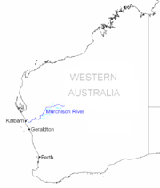
The Murchison River is the second longest river in Western Australia
. It flows for about 780 km (484.7 mi) from the southern edge of the Robinson Ranges
to the Indian Ocean
at Kalbarri
. It has a mean annual flow of about 200 million cubic metres.
 The Murchison River arises on the southern slopes of the Robinson Ranges
, about 75 kilometres north of Meekatharra in central Western Australia
. From there it flows in a westerly direction for about 130 kilometres to its juncture with the Yalgar River
, then west for another 100 kilometres before turning south-south-west for 120 kilometres, at which point it is joined by the Roderick River, about 30 kilometres east of the Murchison Settlement. Another 70 kilometres to the south-south-west it meets its other important tributary, the Sanford River. Over the next 100 kilometres it makes a number of sharp turns, taking it about 70 kilometres to the west. It then flows to the southwest, passing under the North West Coastal Highway
at the Galena Bridge. Entering the Kalbarri National Park
, it flows first to the north-west and then to the north, flowing through the Murchison Gorge, and passing through a number of tight bends known as the Z Bend
and The Loop respectively. It eventually turns to the south-west, passing through one more dogleg before disgorging itself into the Indian Ocean
at Kalbarri, the only settlement at any point along the river.
, a geological sequence rich in Ordovician
trace fossil
s.
s and the inflow of saline sea water. When river flow is low, the estuary accumulates sediment
from the ocean, narrowing the river channel; this sediment is evacuated to the ocean during periods of high flow, but high flow also brings sediment into the estuary from upriver. Because of the high sediment load, and continual stirring by wind and river flow, the water is turbid.
The mouth of the estuary is a small delta
, closed by a sandbar except for a narrow channel. Although this channel is permanently open, it is usually very narrow and shallow, and so is now dredged every year to allow passage by western rock lobster
fishing boats.
. It extends about 550 km (341.8 mi) inland from the Indian Ocean, onto the Yilgarn Plateau. Rain generally only falls in the upper basin during summer cyclones, so for much of the year the Murchison River does not flow, having dry sandy river beds with occasional permanent pools.
The eastern reaches of the basin contain large chains of salt lakes, which flow only following rainfall. The drainage lines from these lakes merge to form the Murchison River about 90 km (55.9 mi) north north east of Meekatharra
, near Peak Hill
. From here the river flows west, then south west, then west to the Indian Ocean.
, who reached the river in 1839; the name honours the Scottist
geologist
Sir Roderick Murchison
.
The estuary and river mouth was used as a holiday destination by families from the Galena
mines in the 1920s and 1930s, and a military holiday camp was built there during World War II
. In 1951 the town of Kalbarri was gazetted at the river mouth, and by the end of the 1990s the population was about 2,000. In 1963 the Kalbarri National Park
was gazetted, formally protecting the lower reaches of the river, including the gorge.
The North West Coastal Highway
passes over the river at Galena Bridge, which was opened by the Main Roads Department in December 1983
Western Australia
Western Australia is a state of Australia, occupying the entire western third of the Australian continent. It is bounded by the Indian Ocean to the north and west, the Great Australian Bight and Indian Ocean to the south, the Northern Territory to the north-east and South Australia to the south-east...
. It flows for about 780 km (484.7 mi) from the southern edge of the Robinson Ranges
Robinson Ranges
The Robinson Ranges are a range of hills approximately north of Meekatharra in central Western Australia. The range is a unique physographic feature located within the upper section of the Padbury group sequence in the Palaeoproterozoic basin...
to the Indian Ocean
Indian Ocean
The Indian Ocean is the third largest of the world's oceanic divisions, covering approximately 20% of the water on the Earth's surface. It is bounded on the north by the Indian Subcontinent and Arabian Peninsula ; on the west by eastern Africa; on the east by Indochina, the Sunda Islands, and...
at Kalbarri
Kalbarri, Western Australia
Kalbarri is a coastal town in the Mid West region located 592 km north of Perth, Western Australia. The town is found at the mouth of the Murchison River and has an elevation of...
. It has a mean annual flow of about 200 million cubic metres.
Course
Robinson Ranges
The Robinson Ranges are a range of hills approximately north of Meekatharra in central Western Australia. The range is a unique physographic feature located within the upper section of the Padbury group sequence in the Palaeoproterozoic basin...
, about 75 kilometres north of Meekatharra in central Western Australia
Western Australia
Western Australia is a state of Australia, occupying the entire western third of the Australian continent. It is bounded by the Indian Ocean to the north and west, the Great Australian Bight and Indian Ocean to the south, the Northern Territory to the north-east and South Australia to the south-east...
. From there it flows in a westerly direction for about 130 kilometres to its juncture with the Yalgar River
Yalgar River
The Yalgar River is a 142-kilometre-long tributary of the Murchison River, located in the Shire of Meekatharra in central Western Australia. It arises near the Great Northern Highway about 50 kilometres north of Meekatharra, flowing about 75 kilometres westward to a junction with its tributary, the...
, then west for another 100 kilometres before turning south-south-west for 120 kilometres, at which point it is joined by the Roderick River, about 30 kilometres east of the Murchison Settlement. Another 70 kilometres to the south-south-west it meets its other important tributary, the Sanford River. Over the next 100 kilometres it makes a number of sharp turns, taking it about 70 kilometres to the west. It then flows to the southwest, passing under the North West Coastal Highway
North West Coastal Highway
North West Coastal Highway in Western Australia is a generally north-south Western Australian highway which links the fishing town of Geraldton with the iron ore port of Port Hedland. It is long, and constructed as a sealed 2-lane single carriageway with overtaking lanes in some parts. It was...
at the Galena Bridge. Entering the Kalbarri National Park
Kalbarri National Park
Kalbarri National Park is located north of Perth. The major geographical features of the park include the Murchison River gorge which runs for nearly 80 kilometres on the lower reaches of the Murchison River...
, it flows first to the north-west and then to the north, flowing through the Murchison Gorge, and passing through a number of tight bends known as the Z Bend
Z Bend
The Z Bend is a popular tourist lookout on the Murchison River Gorge in Western Australia. It is located at , about 30 kilometres east of Kalbarri, in the Kalbarri National Park. One of four lookouts in the national park, it is situated on a sharp bend in the gorge...
and The Loop respectively. It eventually turns to the south-west, passing through one more dogleg before disgorging itself into the Indian Ocean
Indian Ocean
The Indian Ocean is the third largest of the world's oceanic divisions, covering approximately 20% of the water on the Earth's surface. It is bounded on the north by the Indian Subcontinent and Arabian Peninsula ; on the west by eastern Africa; on the east by Indochina, the Sunda Islands, and...
at Kalbarri, the only settlement at any point along the river.
Murchison Gorge
Murchison Gorge is deep gorge in near pristine condition. It is popular with tourists, and there are a number of tourist lookouts. It is also of geological importance, as it exposes an excellent section through the Tumblagooda SandstoneTumblagooda sandstone
The Tumblagooda sandstone is a geological formation deposited during the Silurian or Ordovician periods, around four to five hundred million years ago, and is now exposed on the west coast of Australia, straddling the boundary of the Carnarvon and Perth basins...
, a geological sequence rich in Ordovician
Ordovician
The Ordovician is a geologic period and system, the second of six of the Paleozoic Era, and covers the time between 488.3±1.7 to 443.7±1.5 million years ago . It follows the Cambrian Period and is followed by the Silurian Period...
trace fossil
Fossil
Fossils are the preserved remains or traces of animals , plants, and other organisms from the remote past...
s.
Estuary
The final 18 kilometres of the Murchison River, from the Murchison House Ford to the mouth, are estuarine, and consist of a sequence of long sandbars and shallow pools mostly less than a metre deep. The estuary is permanently open to the sea, so is constantly affected by tideTide
Tides are the rise and fall of sea levels caused by the combined effects of the gravitational forces exerted by the moon and the sun and the rotation of the Earth....
s and the inflow of saline sea water. When river flow is low, the estuary accumulates sediment
Sediment
Sediment is naturally occurring material that is broken down by processes of weathering and erosion, and is subsequently transported by the action of fluids such as wind, water, or ice, and/or by the force of gravity acting on the particle itself....
from the ocean, narrowing the river channel; this sediment is evacuated to the ocean during periods of high flow, but high flow also brings sediment into the estuary from upriver. Because of the high sediment load, and continual stirring by wind and river flow, the water is turbid.
The mouth of the estuary is a small delta
River delta
A delta is a landform that is formed at the mouth of a river where that river flows into an ocean, sea, estuary, lake, reservoir, flat arid area, or another river. Deltas are formed from the deposition of the sediment carried by the river as the flow leaves the mouth of the river...
, closed by a sandbar except for a narrow channel. Although this channel is permanently open, it is usually very narrow and shallow, and so is now dredged every year to allow passage by western rock lobster
Western rock lobster
Panulirus cygnus is a species of spiny lobster , found off the west coast of Australia. Panulirus cygnus is the basis of Australia's most valuable fishery, making up 20% of value of Australia's total fishing industry, and is identified as the western rock lobster.-Description:The species has five...
fishing boats.
Basin
The Murchison River basin covers an area of about 82,000 km² in the Mid West region of Western AustraliaMid West region of Western Australia
The Mid West region is one of the nine regions of Western Australia. It is a very sparsely populated region located on the west coast of Western Australia, extending about north and south of its administrative centre of Geraldton. To the east it extends more than inland to Wiluna in the Gibson...
. It extends about 550 km (341.8 mi) inland from the Indian Ocean, onto the Yilgarn Plateau. Rain generally only falls in the upper basin during summer cyclones, so for much of the year the Murchison River does not flow, having dry sandy river beds with occasional permanent pools.
The eastern reaches of the basin contain large chains of salt lakes, which flow only following rainfall. The drainage lines from these lakes merge to form the Murchison River about 90 km (55.9 mi) north north east of Meekatharra
Meekatharra, Western Australia
Meekatharra is a town in the Mid West region of Western Australia. Meekatharra is an Australian Aboriginal word meaning 'place of little water'. At the 2006 census, Meekatharra had a population of 798, with 44.0% being Aboriginal....
, near Peak Hill
Peak Hill, Western Australia
Peak Hill is the name of a goldfield, locality and the site of a gold mining ghost town in the Murchison Region of Western Australia. The gold mine covers 2,162 hectares and consists of four open-cut mines, titled Main, Jubilee, Fiveways and Harmony....
. From here the river flows west, then south west, then west to the Indian Ocean.
History
The Murchison River was named by the explorer George GreyGeorge Edward Grey
Sir George Grey, KCB was a soldier, explorer, Governor of South Australia, twice Governor of New Zealand, Governor of Cape Colony , the 11th Premier of New Zealand and a writer.-Early life and exploration:...
, who reached the river in 1839; the name honours the Scottist
Scotland
Scotland is a country that is part of the United Kingdom. Occupying the northern third of the island of Great Britain, it shares a border with England to the south and is bounded by the North Sea to the east, the Atlantic Ocean to the north and west, and the North Channel and Irish Sea to the...
geologist
Geology
Geology is the science comprising the study of solid Earth, the rocks of which it is composed, and the processes by which it evolves. Geology gives insight into the history of the Earth, as it provides the primary evidence for plate tectonics, the evolutionary history of life, and past climates...
Sir Roderick Murchison
Roderick Murchison
Sir Roderick Impey Murchison, 1st Baronet KCB DCL FRS FRSE FLS PRGS PBA MRIA was a Scottish geologist who first described and investigated the Silurian system.-Early life and work:...
.
The estuary and river mouth was used as a holiday destination by families from the Galena
Galena
Galena is the natural mineral form of lead sulfide. It is the most important lead ore mineral.Galena is one of the most abundant and widely distributed sulfide minerals. It crystallizes in the cubic crystal system often showing octahedral forms...
mines in the 1920s and 1930s, and a military holiday camp was built there during World War II
World War II
World War II, or the Second World War , was a global conflict lasting from 1939 to 1945, involving most of the world's nations—including all of the great powers—eventually forming two opposing military alliances: the Allies and the Axis...
. In 1951 the town of Kalbarri was gazetted at the river mouth, and by the end of the 1990s the population was about 2,000. In 1963 the Kalbarri National Park
Kalbarri National Park
Kalbarri National Park is located north of Perth. The major geographical features of the park include the Murchison River gorge which runs for nearly 80 kilometres on the lower reaches of the Murchison River...
was gazetted, formally protecting the lower reaches of the river, including the gorge.
The North West Coastal Highway
North West Coastal Highway
North West Coastal Highway in Western Australia is a generally north-south Western Australian highway which links the fishing town of Geraldton with the iron ore port of Port Hedland. It is long, and constructed as a sealed 2-lane single carriageway with overtaking lanes in some parts. It was...
passes over the river at Galena Bridge, which was opened by the Main Roads Department in December 1983
Further reading
- Curry, P.J. et al. (1994) An inventory and condition survey of the Murchison River catchment and surrounds, Western Australia. Department of Agriculture, Western Australia: Technical Bulletin Number 84. ISBN 0-7309-5998-8
- Western Australia. Dept. of Land Administration. Cartographic Services Branch.(1991) Land systems of the Murchison River catchment and surrounds : map series to accompany W.A. Department of Agriculture technical bulletin no. 84 Map Data: Scale 1:250,000 (E 115o10'--E 118o45'/S 25o—S 28o10').Notes: Land systems of the Murchison River catchment and surrounds by K.A. Leighton ... [et al.]. Date of survey: 1986-1988. Location maps:Belele, Byro, Cue, Glenburgh, Murgoo, Robinson Range.