
Christmas 1994 Nor'easter
Encyclopedia
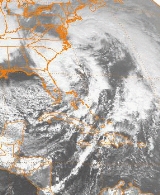
The Christmas 1994 nor'easter was an intense cyclone
along the East Coast of the United States
and Atlantic Canada
. It developed from an area of low pressure in the southeast Gulf of Mexico
near the Florida Keys
, and moved across the state of Florida
. As it entered the warm waters of the Gulf Stream
in the Atlantic Ocean, it began to rapidly intensify, exhibiting traits of a tropical system
, including the formation of an eye
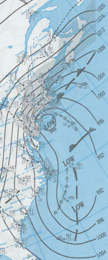
. It attained a pressure of 970 millibars
on December 23 and 24, and after moving northward, it came ashore near New York City on Christmas Eve. Because of the uncertain nature of the storm, the National Hurricane Center
(NHC) did not classify it as a tropical cyclone.
Heavy rain from the developing storm contributed to significant flooding in South Carolina
. Much of the rest of the East Coast was affected by high winds, coastal flooding, and beach erosion. New York
State and New England
bore the brunt of the storm; damage was extensive on Long Island
, and in Connecticut
, 130,000 households lost electric power during the storm. Widespread damage and power outages also occurred throughout Rhode Island
and Massachusetts
, where the storm generated 30 feet (9.1 m) waves along the coast. Because of the warm weather pattern that contributed to the storm's development, precipitation was limited to rain. Two people were killed, and damage amounted to at least $21 million.
 The storm originated in an upper-level low pressure system that moved southeastward from the central Great Plains
into the Deep South
of the United States. After reaching the southeast Gulf of Mexico, the disturbance underwent cyclogenesis, and the resultant system moved through Florida on December 22 in response to an approaching trough
. National Hurricane Center
forecaster Jack Beven noted that "as it moved out into the Bahamas, it appeared to take on the characteristics of a tropical storm." The uncertain nature of the storm prevented the NHC from issuing advisories on it, and forecasters lacked sufficient data to fully assess the cyclone for potential tropical characteristics
. The same trough that pushed the storm across Florida had moved to the north, allowing for high pressure to develop in the upper levels of the atmosphere.
Deemed a "hybrid storm", the cyclone rapidly intensified in warm waters of up to 80 °F (26.7 °C) from the Gulf Stream combined with a cold air mass over the United States. The system continued to rapidly intensify while moving within the Gulf Stream; it developed central convection
, an unusual trait for an extratropical cyclone
, and at one point exhibited an eye
. Despite these indications of tropical characteristics, "There was no front associated with it and it had a warm core, but the radius of maximum winds was more than 150 nmi (172.6 mi; 277.8 km), so under the standard NHC criteria it didn't qualify as a tropical storm." On December 23 and 24, the nor'easter
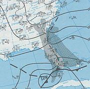
intensified to attain a barometric pressure of 970 mb. An upper-level low pressure system that developed behind the storm began to intensify and grew to be larger in size than the original disturbance. In an interaction known as the Fujiwhara effect
, the broad circulation of the secondary low swung the primary nor'easter northwestward towards southern New York and New England. The original low passed along the south shore of Long Island
, and made landfall near New York City on December 24. Subsequently, it moved over southeastern New York State. On December 25, the system began to rapidly weaken as it moved towards Nova Scotia
, before the pair of low pressure systems moved out to sea in tandem in the early hours of December 26.
were forced to evacuate because of the flooding, and at least 200 homes were damaged. Two deaths were reported in the state. One woman was killed when her vehicle hydroplaned and struck a tree, and another person drowned after her car was struck by another vehicle. Total damage in South Carolina amounted to at least $4 million dollars.
 Strong winds occurred along the North Carolina coast. Diamond Shoals reported sustained winds of 45 miles per hour (72.4 km/h), and offshore, winds gusted to 65 miles per hour (104.6 km/h). On Wrightsville Beach
, rough surf eroded an 8 feet (2.4 m) ledge into the beach. On Carolina Beach, dunes were breached and some roads, including portions of North Carolina Highway 12, were closed.
on December 23. Winds of 35 to 45 mph (56.3 to 72.4 km/h) and tides to 1 to 3 ft (0.3048 to 0.9144 m) above normal were reported. In Sandbridge, Virginia Beach, Virginia
, a beachfront home collapsed into the sea. Several roads throughout the region suffered minor flooding. Strong winds resulting from the tight pressure gradient between the nor'easter and an area of high pressure located over the United States brought down a few utility poles, which sparked a brush fire on December 24. The fire, quickly spread by the wind, burned a field. The winds brought down several trees.
Damage was light in Maryland
. Some sand dunes and wooden structures were damaged, and above-normal tides occurred. In New Jersey
, high winds caused power outages and knocked down trees and power lines. Minor coastal flooding of streets and houses was reported. Otherwise, damage in the state was minor.
The storm brought heavy rainfall and high winds to New York State and New York City on December 23 and 24. Gusts of 60 to 80 mph (26.8 to 35.8 ) downed hundreds of trees and many power lines on Long Island
. Several homes, in addition to many cars, sustained damage. Roughly 112,000 Long Island Lighting Company
customers experienced power outages at some point during the storm. As the cyclone progressed northward into New York State, high winds occurred in the Hudson Valley
region. Throughout Columbia
, Ulster
and Rensselaer
Counties, trees, tree limbs, and power lines were downed by the winds. At Stephentown
, a gust of 58 miles per hour (93.3 km/h) was reported. Ulster County suffered substantial impacts, with large trees being uprooted and striking homes. Across eastern New York State, 25,000 households lost power as a result of the nor'easter. On the North Fork
of Long Island, in Southold
, a seaside home partially collapsed into the water.
, the storm was described as being more significant than anticipated. Gale-force wind gusts, reaching 70 miles per hour (112.7 km/h), blew across the state from the northeast and later from the east. Trees, tree limbs, and power lines were downed, causing damage to property and vehicles. The high winds caused widespread power outages, affecting up to 130,000 electric customers. As a result, electric companies sought help from as far as Pennsylvania
and Maine
to restore electricity. Bruno Ranniello, a spokesman for Northeast Utilities
, reported that "We've had outages in virtually every community." In New Haven
, the nor'easter ripped three barges from their moorings. One of the barges traveled across the Long Island Sound
and ran aground near Port Jefferson, New York
. A man in Milford
was killed indirectly when a tree that was partially downed by the storm fell on him during an attempt to remove it from a relative's yard. Northeast Utilities, which reported the majority of the power outages, estimated storm damage in the state to be about $6–$8 million (1994 USD; $8.8–$11.8 million 2008 USD).
Effects were less severe in New Hampshire
and Vermont
. In southern New Hampshire, a line of thunderstorms produced torrential rainfall, causing flooding on parts of New Hampshire Route 13
. Flash flood
ing of several tributaries
feeding into the Piscataquog River
was reported. In Maine
, the storm brought high winds and heavy rain. Along the coast of southern Maine and New Hampshire, beach erosion was reported. Additionally, minor flooding was reported across the region, as a result of heavy surface runoff
and small ice jams. In Rhode Island
, the power outages were the worst since Hurricane Bob
of the 1991 Atlantic hurricane season
. Throughout the state, approximately 40,000 customers were without electric power. As with Massachusetts, downed trees and property damage were widespread. There were many reports of roof shingle
s being blown off roofs and of damage to gutters. In Warwick
, several small boats were damaged after being knocked into other boats. The highest reported wind gust in the state was 74 miles per hour (119.1 km/h) at Ashaway, Rhode Island
. Statewide damage totaled about $5 million.
Massachusetts, particularly Cape Cod
and Nantucket, bore the brunt of the nor'easter. Reportedly, wind gusts approached 100 miles per hour (160.9 km/h) on Cape Cod and, offshore, waves reached 30 feet (9.1 m). At Walpole
, wind gusts peaked at 88 miles per hour (141.6 km/h), while on Nantucket gusts of 84 miles per hour (135.2 km/h) were reported. The winds left 30,000 electric customers without power during the storm, primarily in the eastern part of the state. Power was out for some as long as 48 hours. Property damage was widespread and many trees, signs, and billboards were blown down. A large tent used by the New England Patriots
was ripped and blown off its foundation. The winds also spread a deadly house fire in North Attleboro. Although not directly related to the storm, it caused seven fatalities. Because tides were low, little coastal flooding occurred. Outside the Prudential Tower Center in Boston, the storm toppled a 50 feet (15.2 m) Christmas tree
. Rainfall of 2 to 3.5 in (50.8 to 88.9 mm) was recorded throughout the eastern part of the state, contributing to heavy runoff that washed away a 400 feet (121.9 m) section of a highway. Total damage in Massachusetts is estimated at about $5 million.
Cyclone
In meteorology, a cyclone is an area of closed, circular fluid motion rotating in the same direction as the Earth. This is usually characterized by inward spiraling winds that rotate anticlockwise in the Northern Hemisphere and clockwise in the Southern Hemisphere of the Earth. Most large-scale...
along the East Coast of the United States
East Coast of the United States
The East Coast of the United States, also known as the Eastern Seaboard, refers to the easternmost coastal states in the United States, which touch the Atlantic Ocean and stretch up to Canada. The term includes the U.S...
and Atlantic Canada
Atlantic Canada
Atlantic Canada is the region of Canada comprising the four provinces located on the Atlantic coast, excluding Quebec: the three Maritime provinces – New Brunswick, Prince Edward Island, and Nova Scotia – and Newfoundland and Labrador...
. It developed from an area of low pressure in the southeast Gulf of Mexico
Gulf of Mexico
The Gulf of Mexico is a partially landlocked ocean basin largely surrounded by the North American continent and the island of Cuba. It is bounded on the northeast, north and northwest by the Gulf Coast of the United States, on the southwest and south by Mexico, and on the southeast by Cuba. In...
near the Florida Keys
Florida Keys
The Florida Keys are a coral archipelago in southeast United States. They begin at the southeastern tip of the Florida peninsula, about south of Miami, and extend in a gentle arc south-southwest and then westward to Key West, the westernmost of the inhabited islands, and on to the uninhabited Dry...
, and moved across the state of Florida
Florida
Florida is a state in the southeastern United States, located on the nation's Atlantic and Gulf coasts. It is bordered to the west by the Gulf of Mexico, to the north by Alabama and Georgia and to the east by the Atlantic Ocean. With a population of 18,801,310 as measured by the 2010 census, it...
. As it entered the warm waters of the Gulf Stream
Gulf Stream
The Gulf Stream, together with its northern extension towards Europe, the North Atlantic Drift, is a powerful, warm, and swift Atlantic ocean current that originates at the tip of Florida, and follows the eastern coastlines of the United States and Newfoundland before crossing the Atlantic Ocean...
in the Atlantic Ocean, it began to rapidly intensify, exhibiting traits of a tropical system
Tropical cyclone
A tropical cyclone is a storm system characterized by a large low-pressure center and numerous thunderstorms that produce strong winds and heavy rain. Tropical cyclones strengthen when water evaporated from the ocean is released as the saturated air rises, resulting in condensation of water vapor...
, including the formation of an eye
Eye (cyclone)
The eye is a region of mostly calm weather found at the center of strong tropical cyclones. The eye of a storm is a roughly circular area and typically 30–65 km in diameter. It is surrounded by the eyewall, a ring of towering thunderstorms where the second most severe weather of a cyclone...
. It attained a pressure of 970 millibars
Bar (unit)
The bar is a unit of pressure equal to 100 kilopascals, and roughly equal to the atmospheric pressure on Earth at sea level. Other units derived from the bar are the megabar , kilobar , decibar , centibar , and millibar...
on December 23 and 24, and after moving northward, it came ashore near New York City on Christmas Eve. Because of the uncertain nature of the storm, the National Hurricane Center
National Hurricane Center
The National Hurricane Center , located at Florida International University in Miami, Florida, is the division of the National Weather Service responsible for tracking and predicting weather systems within the tropics between the Prime Meridian and the 140th meridian west poleward to the 30th...
(NHC) did not classify it as a tropical cyclone.
Heavy rain from the developing storm contributed to significant flooding in South Carolina
South Carolina
South Carolina is a state in the Deep South of the United States that borders Georgia to the south, North Carolina to the north, and the Atlantic Ocean to the east. Originally part of the Province of Carolina, the Province of South Carolina was one of the 13 colonies that declared independence...
. Much of the rest of the East Coast was affected by high winds, coastal flooding, and beach erosion. New York
New York
New York is a state in the Northeastern region of the United States. It is the nation's third most populous state. New York is bordered by New Jersey and Pennsylvania to the south, and by Connecticut, Massachusetts and Vermont to the east...
State and New England
New England
New England is a region in the northeastern corner of the United States consisting of the six states of Maine, New Hampshire, Vermont, Massachusetts, Rhode Island, and Connecticut...
bore the brunt of the storm; damage was extensive on Long Island
Long Island
Long Island is an island located in the southeast part of the U.S. state of New York, just east of Manhattan. Stretching northeast into the Atlantic Ocean, Long Island contains four counties, two of which are boroughs of New York City , and two of which are mainly suburban...
, and in Connecticut
Connecticut
Connecticut is a state in the New England region of the northeastern United States. It is bordered by Rhode Island to the east, Massachusetts to the north, and the state of New York to the west and the south .Connecticut is named for the Connecticut River, the major U.S. river that approximately...
, 130,000 households lost electric power during the storm. Widespread damage and power outages also occurred throughout Rhode Island
Rhode Island
The state of Rhode Island and Providence Plantations, more commonly referred to as Rhode Island , is a state in the New England region of the United States. It is the smallest U.S. state by area...
and Massachusetts
Massachusetts
The Commonwealth of Massachusetts is a state in the New England region of the northeastern United States of America. It is bordered by Rhode Island and Connecticut to the south, New York to the west, and Vermont and New Hampshire to the north; at its east lies the Atlantic Ocean. As of the 2010...
, where the storm generated 30 feet (9.1 m) waves along the coast. Because of the warm weather pattern that contributed to the storm's development, precipitation was limited to rain. Two people were killed, and damage amounted to at least $21 million.
Meteorological history
Great Plains
The Great Plains are a broad expanse of flat land, much of it covered in prairie, steppe and grassland, which lies west of the Mississippi River and east of the Rocky Mountains in the United States and Canada. This area covers parts of the U.S...
into the Deep South
Deep South
The Deep South is a descriptive category of the cultural and geographic subregions in the American South. Historically, it is differentiated from the "Upper South" as being the states which were most dependent on plantation type agriculture during the pre-Civil War period...
of the United States. After reaching the southeast Gulf of Mexico, the disturbance underwent cyclogenesis, and the resultant system moved through Florida on December 22 in response to an approaching trough
Trough (meteorology)
A trough is an elongated region of relatively low atmospheric pressure, often associated with fronts.Unlike fronts, there is not a universal symbol for a trough on a weather chart. The weather charts in some countries or regions mark troughs by a line. In the United States, a trough may be marked...
. National Hurricane Center
National Hurricane Center
The National Hurricane Center , located at Florida International University in Miami, Florida, is the division of the National Weather Service responsible for tracking and predicting weather systems within the tropics between the Prime Meridian and the 140th meridian west poleward to the 30th...
forecaster Jack Beven noted that "as it moved out into the Bahamas, it appeared to take on the characteristics of a tropical storm." The uncertain nature of the storm prevented the NHC from issuing advisories on it, and forecasters lacked sufficient data to fully assess the cyclone for potential tropical characteristics
Tropical cyclone
A tropical cyclone is a storm system characterized by a large low-pressure center and numerous thunderstorms that produce strong winds and heavy rain. Tropical cyclones strengthen when water evaporated from the ocean is released as the saturated air rises, resulting in condensation of water vapor...
. The same trough that pushed the storm across Florida had moved to the north, allowing for high pressure to develop in the upper levels of the atmosphere.
Deemed a "hybrid storm", the cyclone rapidly intensified in warm waters of up to 80 °F (26.7 °C) from the Gulf Stream combined with a cold air mass over the United States. The system continued to rapidly intensify while moving within the Gulf Stream; it developed central convection
Atmospheric convection
Atmospheric convection is the result of a parcel-environment instability, or temperature difference, layer in the atmosphere. Different lapse rates within dry and moist air lead to instability. Mixing of air during the day which expands the height of the planetary boundary layer leads to...
, an unusual trait for an extratropical cyclone
Extratropical cyclone
Extratropical cyclones, sometimes called mid-latitude cyclones or wave cyclones, are a group of cyclones defined as synoptic scale low pressure weather systems that occur in the middle latitudes of the Earth having neither tropical nor polar characteristics, and are connected with fronts and...
, and at one point exhibited an eye
Eye (cyclone)
The eye is a region of mostly calm weather found at the center of strong tropical cyclones. The eye of a storm is a roughly circular area and typically 30–65 km in diameter. It is surrounded by the eyewall, a ring of towering thunderstorms where the second most severe weather of a cyclone...
. Despite these indications of tropical characteristics, "There was no front associated with it and it had a warm core, but the radius of maximum winds was more than 150 nmi (172.6 mi; 277.8 km), so under the standard NHC criteria it didn't qualify as a tropical storm." On December 23 and 24, the nor'easter
Nor'easter
A nor'easter is a type of macro-scale storm along the East Coast of the United States and Atlantic Canada, so named because the storm travels to the northeast from the south and the winds come from the northeast, especially in the coastal areas of the Northeastern United States and Atlantic Canada...
intensified to attain a barometric pressure of 970 mb. An upper-level low pressure system that developed behind the storm began to intensify and grew to be larger in size than the original disturbance. In an interaction known as the Fujiwhara effect
Fujiwhara effect
The Fujiwhara effect or Fujiwara interaction, named after Sakuhei Fujiwhara, is a type of interaction between two nearby cyclonic vortices, causing them to appear to "orbit" each other.-Description:...
, the broad circulation of the secondary low swung the primary nor'easter northwestward towards southern New York and New England. The original low passed along the south shore of Long Island
Long Island
Long Island is an island located in the southeast part of the U.S. state of New York, just east of Manhattan. Stretching northeast into the Atlantic Ocean, Long Island contains four counties, two of which are boroughs of New York City , and two of which are mainly suburban...
, and made landfall near New York City on December 24. Subsequently, it moved over southeastern New York State. On December 25, the system began to rapidly weaken as it moved towards Nova Scotia
Nova Scotia
Nova Scotia is one of Canada's three Maritime provinces and is the most populous province in Atlantic Canada. The name of the province is Latin for "New Scotland," but "Nova Scotia" is the recognized, English-language name of the province. The provincial capital is Halifax. Nova Scotia is the...
, before the pair of low pressure systems moved out to sea in tandem in the early hours of December 26.
Southeast United States
In South Carolina, flooding associated with the cyclone was considered to be the worst since 1943. Over 5 inches (127 mm) of rainfall was reported, while winds brought down trees and ripped awnings. In addition, beach erosion occurred along the coast. As a result of the heavy rainfall, several dams breached. Extensive flooding of roads and highways was reported, many of which were closed as a result. Up to 3 foot (0.9144 m) of water flooded some homes in the region. Approximately 300 people in Florence CountyFlorence County, South Carolina
Florence is a county located in the U.S. state of South Carolina. In 2000, its population was recorded to be 125,761; in 2005, the U.S. Census Bureau estimated that its population had reached 131,097. Its county seat is Florence. The county's population is about 60% urban and it comprises part of...
were forced to evacuate because of the flooding, and at least 200 homes were damaged. Two deaths were reported in the state. One woman was killed when her vehicle hydroplaned and struck a tree, and another person drowned after her car was struck by another vehicle. Total damage in South Carolina amounted to at least $4 million dollars.
Wrightsville Beach, North Carolina
Wrightsville Beach is a town in New Hanover County, North Carolina, United States. Wrightsville Beach is just east of Wilmington and is part of the Wilmington Metropolitan Statistical Area. The population was 2,593 at the 2000 census...
, rough surf eroded an 8 feet (2.4 m) ledge into the beach. On Carolina Beach, dunes were breached and some roads, including portions of North Carolina Highway 12, were closed.
Mid-Atlantic
As the primary storm entered New England, the secondary low produced minor coastal flooding in the Tidewater region of VirginiaTidewater region of Virginia
The Tidewater region of Virginia is the eastern portion of the Commonwealth of Virginia formally known as Hampton Roads. The term tidewater may be correctly applied to all portions of any area, including Virginia, where the water level is affected by the tides...
on December 23. Winds of 35 to 45 mph (56.3 to 72.4 km/h) and tides to 1 to 3 ft (0.3048 to 0.9144 m) above normal were reported. In Sandbridge, Virginia Beach, Virginia
Sandbridge, Virginia Beach, Virginia
thumb|250px|A view of a Sandbridge beach from a pierSandbridge, in the U.S. state of Virginia, is a coastal community of Virginia Beach, located along the coastline at the northern end of the Outer Banks. The Atlantic Ocean is to the east, the Back Bay of the Currituck Sound is to the west, and...
, a beachfront home collapsed into the sea. Several roads throughout the region suffered minor flooding. Strong winds resulting from the tight pressure gradient between the nor'easter and an area of high pressure located over the United States brought down a few utility poles, which sparked a brush fire on December 24. The fire, quickly spread by the wind, burned a field. The winds brought down several trees.
Damage was light in Maryland
Maryland
Maryland is a U.S. state located in the Mid Atlantic region of the United States, bordering Virginia, West Virginia, and the District of Columbia to its south and west; Pennsylvania to its north; and Delaware to its east...
. Some sand dunes and wooden structures were damaged, and above-normal tides occurred. In New Jersey
New Jersey
New Jersey is a state in the Northeastern and Middle Atlantic regions of the United States. , its population was 8,791,894. It is bordered on the north and east by the state of New York, on the southeast and south by the Atlantic Ocean, on the west by Pennsylvania and on the southwest by Delaware...
, high winds caused power outages and knocked down trees and power lines. Minor coastal flooding of streets and houses was reported. Otherwise, damage in the state was minor.
The storm brought heavy rainfall and high winds to New York State and New York City on December 23 and 24. Gusts of 60 to 80 mph (26.8 to 35.8 ) downed hundreds of trees and many power lines on Long Island
Long Island
Long Island is an island located in the southeast part of the U.S. state of New York, just east of Manhattan. Stretching northeast into the Atlantic Ocean, Long Island contains four counties, two of which are boroughs of New York City , and two of which are mainly suburban...
. Several homes, in addition to many cars, sustained damage. Roughly 112,000 Long Island Lighting Company
Long Island Lighting Company
The Long Island Lighting Company, or LILCO [ "lil-co" ], was an electrical power company and natural gas utility for the communities of Long Island, New York, serving 2.7 million people in Nassau, Suffolk and Queens Counties....
customers experienced power outages at some point during the storm. As the cyclone progressed northward into New York State, high winds occurred in the Hudson Valley
Hudson Valley
The Hudson Valley comprises the valley of the Hudson River and its adjacent communities in New York State, United States, from northern Westchester County northward to the cities of Albany and Troy.-History:...
region. Throughout Columbia
Columbia County, New York
Columbia County is a county located in the U.S. state of New York. As of the 2010 census, the population was 63,096. The county seat is Hudson. The name comes from the Latin feminine form of the name of Christopher Columbus, which was at the time of the formation of the county a popular proposal...
, Ulster
Ulster County, New York
Ulster County is a county located in the state of New York, USA. It sits in the state's Mid-Hudson Region of the Hudson Valley. As of the 2010 census, the population was 182,493. Recent population estimates completed by the United States Census Bureau for the 12-month period ending July 1 are at...
and Rensselaer
Rensselaer County, New York
Rensselaer County is a county in the U.S. state of New York. As of the 2010 census, the population was 159,429. Its name is in honor of the family of Kiliaen van Rensselaer, the original Dutch owner of the land in the area. Its county seat is Troy...
Counties, trees, tree limbs, and power lines were downed by the winds. At Stephentown
Stephentown, New York
Stephentown is a town in Rensselaer County, New York, United States. The population was 2,873 at the 2000 census. The town is named after Stephen Van Rensselaer. The town is in the southeast corner of the county...
, a gust of 58 miles per hour (93.3 km/h) was reported. Ulster County suffered substantial impacts, with large trees being uprooted and striking homes. Across eastern New York State, 25,000 households lost power as a result of the nor'easter. On the North Fork
North Fork, Suffolk County, New York
The North Fork is a 30-mile-long peninsula in the northeast part of Suffolk County, New York, roughly parallel with an even longer peninsula known as the South Fork...
of Long Island, in Southold
Southold, New York
Southold is one of ten towns in Suffolk County, New York, United States. It is located in the northeastern tip of the county, on the North Fork of Long Island. The population was 20,599 at the 2000 census...
, a seaside home partially collapsed into the water.
New England
In ConnecticutConnecticut
Connecticut is a state in the New England region of the northeastern United States. It is bordered by Rhode Island to the east, Massachusetts to the north, and the state of New York to the west and the south .Connecticut is named for the Connecticut River, the major U.S. river that approximately...
, the storm was described as being more significant than anticipated. Gale-force wind gusts, reaching 70 miles per hour (112.7 km/h), blew across the state from the northeast and later from the east. Trees, tree limbs, and power lines were downed, causing damage to property and vehicles. The high winds caused widespread power outages, affecting up to 130,000 electric customers. As a result, electric companies sought help from as far as Pennsylvania
Pennsylvania
The Commonwealth of Pennsylvania is a U.S. state that is located in the Northeastern and Mid-Atlantic regions of the United States. The state borders Delaware and Maryland to the south, West Virginia to the southwest, Ohio to the west, New York and Ontario, Canada, to the north, and New Jersey to...
and Maine
Maine
Maine is a state in the New England region of the northeastern United States, bordered by the Atlantic Ocean to the east and south, New Hampshire to the west, and the Canadian provinces of Quebec to the northwest and New Brunswick to the northeast. Maine is both the northernmost and easternmost...
to restore electricity. Bruno Ranniello, a spokesman for Northeast Utilities
Northeast Utilities
Northeast Utilities is a publicly-traded, Fortune 500 energy company headquartered in Berlin, Connecticut, with several regulated subsidiaries offering retail electricity and natural gas service to more than 2.1 million customers in New England....
, reported that "We've had outages in virtually every community." In New Haven
New Haven, Connecticut
New Haven is the second-largest city in Connecticut and the sixth-largest in New England. According to the 2010 Census, New Haven's population increased by 5.0% between 2000 and 2010, a rate higher than that of the State of Connecticut, and higher than that of the state's five largest cities, and...
, the nor'easter ripped three barges from their moorings. One of the barges traveled across the Long Island Sound
Long Island Sound
Long Island Sound is an estuary of the Atlantic Ocean, located in the United States between Connecticut to the north and Long Island, New York to the south. The mouth of the Connecticut River at Old Saybrook, Connecticut, empties into the sound. On its western end the sound is bounded by the Bronx...
and ran aground near Port Jefferson, New York
Port Jefferson, New York
The Incorporated Village of Port Jefferson is located in the town of Brookhaven in Suffolk County, New York on the North Shore of Long Island. As of the 2000 United States Census, the village population was 7,837...
. A man in Milford
Milford, Connecticut
Milford is a coastal city in southwestern New Haven County, Connecticut, United States, located between Bridgeport and New Haven. The population was 52,759 at the 2010 census...
was killed indirectly when a tree that was partially downed by the storm fell on him during an attempt to remove it from a relative's yard. Northeast Utilities, which reported the majority of the power outages, estimated storm damage in the state to be about $6–$8 million (1994 USD; $8.8–$11.8 million 2008 USD).
Effects were less severe in New Hampshire
New Hampshire
New Hampshire is a state in the New England region of the northeastern United States of America. The state was named after the southern English county of Hampshire. It is bordered by Massachusetts to the south, Vermont to the west, Maine and the Atlantic Ocean to the east, and the Canadian...
and Vermont
Vermont
Vermont is a state in the New England region of the northeastern United States of America. The state ranks 43rd in land area, , and 45th in total area. Its population according to the 2010 census, 630,337, is the second smallest in the country, larger only than Wyoming. It is the only New England...
. In southern New Hampshire, a line of thunderstorms produced torrential rainfall, causing flooding on parts of New Hampshire Route 13
New Hampshire Route 13
New Hampshire Route 13 is a long north–south state highway in the state of New Hampshire, United States. The highway runs from Brookline to Concord....
. Flash flood
Flash flood
A flash flood is a rapid flooding of geomorphic low-lying areas—washes, rivers, dry lakes and basins. It may be caused by heavy rain associated with a storm, hurricane, or tropical storm or meltwater from ice or snow flowing over ice sheets or snowfields...
ing of several tributaries
Tributary
A tributary or affluent is a stream or river that flows into a main stem river or a lake. A tributary does not flow directly into a sea or ocean...
feeding into the Piscataquog River
Piscataquog River
The Piscataquog River is a river located in southern New Hampshire in the United States. It is a tributary of the Merrimack River, which flows to the Gulf of Maine....
was reported. In Maine
Maine
Maine is a state in the New England region of the northeastern United States, bordered by the Atlantic Ocean to the east and south, New Hampshire to the west, and the Canadian provinces of Quebec to the northwest and New Brunswick to the northeast. Maine is both the northernmost and easternmost...
, the storm brought high winds and heavy rain. Along the coast of southern Maine and New Hampshire, beach erosion was reported. Additionally, minor flooding was reported across the region, as a result of heavy surface runoff
Surface runoff
Surface runoff is the water flow that occurs when soil is infiltrated to full capacity and excess water from rain, meltwater, or other sources flows over the land. This is a major component of the water cycle. Runoff that occurs on surfaces before reaching a channel is also called a nonpoint source...
and small ice jams. In Rhode Island
Rhode Island
The state of Rhode Island and Providence Plantations, more commonly referred to as Rhode Island , is a state in the New England region of the United States. It is the smallest U.S. state by area...
, the power outages were the worst since Hurricane Bob
Hurricane Bob
Hurricane Bob was one of the costliest hurricanes in New England history. The second named storm and first hurricane of the 1991 Atlantic hurricane season, Bob developed from an area of low pressure near The Bahamas on August 16. The depression steadily intensified, and became Tropical Storm Bob...
of the 1991 Atlantic hurricane season
1991 Atlantic hurricane season
The 1991 Atlantic hurricane season was the first season in over 24 years in which no hurricanes developed from tropical waves, which are the source for most North Atlantic tropical cyclones. The hurricane season officially began on June 1, and ended on November 30. It was the least...
. Throughout the state, approximately 40,000 customers were without electric power. As with Massachusetts, downed trees and property damage were widespread. There were many reports of roof shingle
Roof shingle
Roof shingles are a roof covering consisting of individual overlapping elements. These elements are typically flat rectangular shapes laid in rows from the bottom edge of the roof up, with each successive higher row overlapping the joints in the row below...
s being blown off roofs and of damage to gutters. In Warwick
Warwick, Rhode Island
Warwick is a city in Kent County, Rhode Island, United States. It is the second largest city in the state, with a population of 82,672 at the 2010 census. Its mayor has been Scott Avedisian since 2000...
, several small boats were damaged after being knocked into other boats. The highest reported wind gust in the state was 74 miles per hour (119.1 km/h) at Ashaway, Rhode Island
Ashaway, Rhode Island
Ashaway is an unincorporated village and census-designated place in the town of Hopkinton in Washington County, Rhode Island, United States. The population was 1,537 at the 2000 census.-Geography:Ashaway is located at ....
. Statewide damage totaled about $5 million.
Massachusetts, particularly Cape Cod
Cape Cod
Cape Cod, often referred to locally as simply the Cape, is a cape in the easternmost portion of the state of Massachusetts, in the Northeastern United States...
and Nantucket, bore the brunt of the nor'easter. Reportedly, wind gusts approached 100 miles per hour (160.9 km/h) on Cape Cod and, offshore, waves reached 30 feet (9.1 m). At Walpole
Walpole, Massachusetts
Walpole is a town in Norfolk County, Massachusetts, United States. It is located about south of Boston and north of Providence, Rhode Island. The population was 24,070 at the 2010 census. Walpole was first settled in 1659 and was considered a part of Dedham until officially incorporated in 1724...
, wind gusts peaked at 88 miles per hour (141.6 km/h), while on Nantucket gusts of 84 miles per hour (135.2 km/h) were reported. The winds left 30,000 electric customers without power during the storm, primarily in the eastern part of the state. Power was out for some as long as 48 hours. Property damage was widespread and many trees, signs, and billboards were blown down. A large tent used by the New England Patriots
New England Patriots
The New England Patriots, commonly called the "Pats", are a professional football team based in the Greater Boston area, playing their home games in the town of Foxborough, Massachusetts at Gillette Stadium. The team is part of the East Division of the American Football Conference in the National...
was ripped and blown off its foundation. The winds also spread a deadly house fire in North Attleboro. Although not directly related to the storm, it caused seven fatalities. Because tides were low, little coastal flooding occurred. Outside the Prudential Tower Center in Boston, the storm toppled a 50 feet (15.2 m) Christmas tree
Christmas tree
The Christmas tree is a decorated evergreen coniferous tree, real or artificial, and a tradition associated with the celebration of Christmas. The tradition of decorating an evergreen tree at Christmas started in Livonia and Germany in the 16th century...
. Rainfall of 2 to 3.5 in (50.8 to 88.9 mm) was recorded throughout the eastern part of the state, contributing to heavy runoff that washed away a 400 feet (121.9 m) section of a highway. Total damage in Massachusetts is estimated at about $5 million.
See also
- Timeline of the 1994 Atlantic hurricane seasonTimeline of the 1994 Atlantic hurricane seasonThe 1994 Atlantic hurricane season was a below-average Atlantic hurricane season that produced seven named tropical cyclones. The season officially began on June 1 and ended on November 30, dates which conventionally limit the period of each year when tropical cyclones tend to form in the Atlantic....
- 1994 Atlantic hurricane season1994 Atlantic hurricane seasonThe 1994 Atlantic hurricane seasonofficially began June 1, 1994, and officially ended November 30, 1994. These dates conventionally delimit the period of each year when most tropical cyclones form in the Atlantic basin....
- Extratropical cycloneExtratropical cycloneExtratropical cyclones, sometimes called mid-latitude cyclones or wave cyclones, are a group of cyclones defined as synoptic scale low pressure weather systems that occur in the middle latitudes of the Earth having neither tropical nor polar characteristics, and are connected with fronts and...
- Subtropical cycloneSubtropical cycloneA subtropical cyclone is a weather system that has some characteristics of a tropical and an extratropical cyclone. As early as the 1950s, meteorologists were unclear whether they should be characterized as tropical or extratropical cyclones. They were officially recognized by the National...
- Surface weather analysisSurface weather analysisSurface weather analysis is a special type of weather map that provides a view of weather elements over a geographical area at a specified time based on information from ground-based weather stations...