
California postmile
Encyclopedia
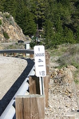
California uses a postmile system on all of its state highway
s, including U.S. Routes and Interstate Highways. The postmile markers indicate the distance a route travels through individual counties, as opposed to mile markers that indicate the distance traveled through a state.
According to the Manual on Uniform Traffic Control Devices
, they, however, encouraged the use of mileposts like all the other states and stated that:
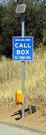
es. A blue placard is mounted on each of the state's callboxes, the top of which shows what county one would be in, and on the bottom, it shows the 2-letter county abbreviation, along with the route number and the location's postmile (in tenths of miles). Postmiles on callboxes are approximate, because of a convention that all callboxes on one side of the road are assigned even numbers, while all those on the other side are assigned odd numbers.
Enforcement officers, maintenance forces and others use the postmile markers in the field to locate specific incidents or features with reference to the postmile system.
On some stretches of road, the following prefixes may precede the mileage on a postmile marker:
The postmile system is the only route reference system used by Caltrans
. In 2002, the State started the Cal-NExUS program, which would create a uniform exit numbering system for freeways. Included was a pilot program for the placing of mile markers along rural freeways. Currently, three freeway segments are apart of the experimental program: the Route 14 Freeway
, the Route 58 Freeway
in Kern County
, and State Route 180
in Fresno
. Caltrans has not decided if the program will be expanded to all rural freeways.
and Ohio
use reference markers very similar to California's postmile markers. Like California, these two states record mileages through individual counties in their respective route logs. Ohio's system is nearly identical to California's with its reference markers listing the route number, 3-letter county abbreviation, and mileage through the county. The Nevada system is also similar, utilizing 2-letter county abbreviations. However, Ohio uses standard mileposts in addition to reference markers on freeways, while Nevada uses mileposts in conjunction with postmile panels on major Interstate highways only. Also, all non-Interstate
s in Illinois
have markers showing mileage from the western or southern border of the county.
State highway
State highway, state road or state route can refer to one of three related concepts, two of them related to a state or provincial government in a country that is divided into states or provinces :#A...
s, including U.S. Routes and Interstate Highways. The postmile markers indicate the distance a route travels through individual counties, as opposed to mile markers that indicate the distance traveled through a state.
Format
A postmile marker is a metal paddle placed along the state highway. Each marker is stenciled with the route, county, and postmile at that location.According to the Manual on Uniform Traffic Control Devices
Manual on Uniform Traffic Control Devices
The Manual on Uniform Traffic Control Devices is a document issued by the Federal Highway Administration of the United States Department of Transportation to specify the standards by which traffic signs, road surface markings, and signals are designed, installed, and used...
, they, however, encouraged the use of mileposts like all the other states and stated that:
Bridge
One of the common formats for postmiles are located on a freeway on bridges over cross streets. According to Caltrans, it displays the name of the bridge, the county and route number, and the postmile. The postmile is often painted onto the piers and/or abutments of bridges and overpasses.Postmile markers
These are the white markers placed at one-mile (1.6 km) intervals, with additional markers placed at significant features along the highway such as bridges and overpasses, junctions, or culverts. The markers are roughly the same size as a standard milepost used elsewhere, but they are white with black text.Callbox
Postmiles are also shown on callboxCallbox
A call box or callbox is a box containing a special-purpose direct line telephone or other telecommunications device, which has been used by various industries and institutions as a way for employees or clients at a remote location to contact a central dispatch office.- Police and taxicab...
es. A blue placard is mounted on each of the state's callboxes, the top of which shows what county one would be in, and on the bottom, it shows the 2-letter county abbreviation, along with the route number and the location's postmile (in tenths of miles). Postmiles on callboxes are approximate, because of a convention that all callboxes on one side of the road are assigned even numbers, while all those on the other side are assigned odd numbers.
County prefixes
Alphabetic prefixes on postmile markers and bridges differ from callbox prefixes because the callbox system is maintained by each county, while Caltrans maintains postmile markers and bridge signs. The following table lists postmile and callbox prefixes by county.| County | Bridge | Callbox | County | Bridge | Callbox |
|---|---|---|---|---|---|
| Alameda Alameda County, California Alameda County is a county in the U.S. state of California. It occupies most of the East Bay region of the San Francisco Bay Area. As of the 2010 census it had a population of 1,510,271, making it the 7th most populous county in the state... |
ALA | AL | Orange Orange County, California Orange County is a county in the U.S. state of California. Its county seat is Santa Ana. As of the 2010 census, its population was 3,010,232, up from 2,846,293 at the 2000 census, making it the third most populous county in California, behind Los Angeles County and San Diego County... |
ORA | OR |
| Alpine Alpine County, California Alpine County is the smallest county, by population, in the U.S. state of California. As of 2010, it had a population of 1,175, all rural. There are no incorporated cities in the county. The county seat is Markleeville... |
ALP | AP | Placer Placer County, California Placer County is a county located in both the Sacramento Valley and Sierra Nevada regions of the U.S. state of California, in what is known as the Gold Country. It stretches from the suburbs of Sacramento to Lake Tahoe and the Nevada border. Because of the expansion of the Greater Sacramento,... |
PLA | PL |
| Amador Amador County, California Amador County is a county located in the Sierra Nevada of the U.S. state of California. As of the 2010 census, the population was 38,091. The county seat is Jackson.Amador County bills itself as "The Heart of the Mother Lode" and lies within the Gold Country... |
AMA | AM | Plumas Plumas County, California Plumas County is a county located in the Sierra Nevada of the U.S. state of California. The county gets its name from the Spanish words for the Feather River , which flows through the county. As of the 2010 census, the population 20,007, down from 20,824 at the 2000 census... |
PLU | PM |
| Butte Butte County, California Butte County is a county located in the Central Valley of the US state of California, north of the state capital of Sacramento. As of the 2010 census, it had a population of 220,000. The county seat is Oroville. Butte County is the "Land of Natural Wealth and Beauty."Butte County is watered by the... |
BUT | BU | Riverside Riverside County, California Riverside County is a county in the U.S. state of California. One of 58 California counties, it covers in the southern part of the state, and stretches from Orange County to the Colorado River, which forms the state border with Arizona. The county derives its name from the city of Riverside,... |
RIV | RV |
| Calaveras Calaveras County, California Calaveras County is a county located in the Gold Country of the U.S. state of California. Calaveras is the Spanish word for skulls; the county was reportedly named for the remains of Native Americans discovered by the Spanish explorer Captain Gabriel Moraga. As of the 2010 census, the county had a... |
CAL | CV | Sacramento Sacramento County, California Sacramento County is a county in the U.S. state of California. Its county seat is Sacramento, which is also the state capital. As of 2010 the county had a population of 1,418,788.... |
SAC | SA |
| Colusa Colusa County, California Colusa County is a county located in the Central Valley of the U.S. state of California, northwest of state capital Sacramento. As of the 2010 census, its population was 21,419. The county seat is Colusa.-History:... |
COL | CO | San Benito San Benito County, California San Benito County is a county located in the Coast Range Mountains of the U.S. state of California, south of San Jose. As of 2010 the population was 55,269. The county seat is Hollister, which includes nearly two-thirds of the county's population. El Camino Real passes through the county and... |
SBT | ST |
| Contra Costa Contra Costa County, California Contra Costa County is a primarily suburban county in the San Francisco Bay Area of the U.S. state of California. As of the 2010 census, it had a population of 1,049,025... |
CC | CC | San Bernardino San Bernardino County, California San Bernardino County is a county in the U.S. state of California. As of the 2010 census, the population was 2,035,210, up from 1,709,434 as of the 2000 census... |
SBD | SB |
| Del Norte Del Norte County, California Del Norte County is a county located at the far northwest corner of the U.S. state of California on the Pacific adjacent to the Oregon border. As of the 2010 census, it had a population of 28,610. The county seat is Crescent City, the county's only incorporated city. Del Norte is the abbreviated... |
DN | DN | San Diego San Diego County, California San Diego County is a large county located in the southwestern corner of the US state of California. Hence, San Diego County is also located in the southwestern corner of the 48 contiguous United States. Its county seat and largest city is San Diego. Its population was about 2,813,835 in the 2000... |
SD | SD |
| El Dorado El Dorado County, California El Dorado County is a county located in the historic Gold Country in the Sierra Nevada Mountains and foothills of the U.S. state of California. The 2010 population was 181,058. The El Dorado county seat is in Placerville.... |
ED | EL | San Francisco | SF | SF |
| Fresno Fresno County, California Fresno County is a county located in the Central Valley of the U.S. state of California, south of Stockton and north of Bakersfield. As of the 2010 census, it is the tenth most populous county in California with a population of 930,450, and the sixth largest in size with an area of . The county... |
FRE | FR | San Joaquin San Joaquin County, California San Joaquin County is a county located in Central Valley of the U.S. state of California, just east of the San Francisco Bay Area. As of the 2010 census, the population was 685,306. The county seat is Stockton.-History:... |
SJ | SJ |
| Glenn Glenn County, California Glenn County is in the California Central Valley. As of 2010, it had a population of 28,122. The county seat is the city of Willows.-History:Glenn County was formed in 1891 from parts of Colusa County. It was named for Dr. Hugh J... |
GLE | GL | San Luis Obispo San Luis Obispo County, California San Luis Obispo County is a county located along the Pacific Ocean in the Central Coast of the U.S. state of California, between Los Angeles and the San Francisco Bay Area. As of the 2010 census its population was 269,637, up from 246,681 at the 2000 census... |
SLO | SL |
| Humboldt Humboldt County, California Humboldt County is a county in the U.S. state of California, located on the far North Coast 200 miles north of San Francisco. According to 2010 Census Data, the county’s population was 134,623... |
HUM | HU | San Mateo San Mateo County, California San Mateo County is a county located in the San Francisco Bay Area of the U.S. state of California. It covers most of the San Francisco Peninsula just south of San Francisco, and north of Santa Clara County. San Francisco International Airport is located at the northern end of the county, and... |
SM | SM |
| Imperial Imperial County, California Imperial County is a county located in the Imperial Valley, in the far southeast of the U.S. state of California, bordering both Arizona and Mexico. It is part of the El Centro Metropolitan Area, which encompasses all of Imperial County. The population as of 2000 was 142,361. The county seat is the... |
IMP | IM | Santa Barbara Santa Barbara County, California Santa Barbara County is a county located in the southern portion of the U.S. state of California, on the Pacific coast. As of 2010 the county had a population of 423,895. The county seat is Santa Barbara and the largest city is Santa Maria.-History:... |
SB | SR |
| Inyo Inyo County, California -National protected areas:* Death Valley National Park * Inyo National Forest * Manzanar National Historic Site-Major highways:* U.S. Route 6* U.S. Route 395* State Route 127* State Route 136* State Route 168* State Route 178... |
INY | IN | Santa Clara Santa Clara County, California Santa Clara County is a county located at the southern end of the San Francisco Bay Area in the U.S. state of California. As of 2010 it had a population of 1,781,642. The county seat is San Jose. The highly urbanized Santa Clara Valley within Santa Clara County is also known as Silicon Valley... |
SCL | SC |
| Kern Kern County, California Spreading across the southern end of the California Central Valley, Kern County is the fifth-largest county by population in California. Its economy is heavily linked to agriculture and to petroleum extraction, and there is a strong aviation and space presence. Politically, it has generally... |
KER | KR | Santa Cruz Santa Cruz County, California Santa Cruz County is a county located on the Pacific coast of the U.S. state of California, on the California Central Coast. The county forms the northern coast of the Monterey Bay. . As of the 2010 U.S. Census, its population was 262,382. The county seat is Santa Cruz... |
SCR | SZ |
| Kings Kings County, California Kings County is a county located in the Central Valley of the U.S. state of California. It is located in a rich agricultural region. Kings County is also home to NAS Lemoore, which is the U.S. Navy's newest and largest master jet air station. The county seat is Hanford... |
KIN | KN | Shasta Shasta County, California Shasta County is a county located in the northern portion of the U.S. state of California. The county occupies the northern reaches of the Sacramento Valley, with portions extending into the southern reaches of the Cascade Range. As of the 2010 census, the population was 177,223, up from 163,256... |
SHA | SH |
| Lake Lake County, California Lake County is a county located in the north central portion of the U.S. state of California, north of the San Francisco Bay Area. It takes its name from Clear Lake, the dominant geographic feature in the county and the largest natural lake wholly within California... |
LAK | LK | Sierra Sierra County, California Sierra County is a county located in the Sierra Nevada of the U.S. state of California, northeast of Sacramento on the border with Nevada. As of the 2010 census the population was 3,240, down from 3,555 at the 2000 census. The county seat is Downieville.... |
SIE | SI |
| Lassen Lassen County, California Lassen County is a county located in the northeastern portion of the U.S. state of California. As of the 2010 census, the population was 34,895, up from 33,828 at the 2000 census... |
LAS | LS | Siskiyou Siskiyou County, California Siskiyou County is a county located in the far northernmost part of the U.S. state of California, in the Shasta Cascade region on the Oregon border. Yreka is the county seat. Because of its substantial natural beauty, outdoor recreation opportunities, and Gold Rush era history, it is an important... |
SIS | SK |
| Los Angeles Los Angeles County, California Los Angeles County is a county in the U.S. state of California. As of 2010 U.S. Census, the county had a population of 9,818,605, making it the most populous county in the United States. Los Angeles County alone is more populous than 42 individual U.S. states... |
LA | LA | Solano Solano County, California Solano County is a county located in Bay-Delta region of the U.S. state of California, about halfway between San Francisco and Sacramento and is one of the nine San Francisco Bay Area counties. The county's population was reported by the U.S. Census to be 413,344 in 2010... |
SOL | SO |
| Madera Madera County, California Madera County is a county of the U.S. state of California, located in the Central Valley and the Sierra Nevada north of Fresno County. It comprises the Madera-Chowchilla, CA Metropolitan Statistical Area. As of the 2010 census the population was 150,865... |
MAD | MD | Sonoma Sonoma County, California Sonoma County, located on the northern coast of the U.S. state of California, is the largest and northernmost of the nine San Francisco Bay Area counties. Its population at the 2010 census was 483,878. Its largest city and county seat is Santa Rosa.... |
SON | SN |
| Marin Marin County, California Marin County is a county located in the North San Francisco Bay Area of the U.S. state of California, across the Golden Gate Bridge from San Francisco. As of 2010, the population was 252,409. The county seat is San Rafael and the largest employer is the county government. Marin County is well... |
MRN | MR | Stanislaus Stanislaus County, California Stanislaus County is a county located in the Central Valley of the U.S. state of California. As the price of housing has increased in the San Francisco Bay Area, many people who work in the southern reaches of the Bay Area have opted for the longer commute and moved to Stanislaus County for the... |
STA | SS |
| Mariposa Mariposa County, California Mariposa County is a county in the U.S. state of California, located in the western foothills of the Sierra Nevada mountains. It lies north of Fresno, east of Merced, and southeast of Stockton. As of the 2010 census, the population was 18,251 up from 17,130 at the 2000 census... |
MPA | MP | Sutter Sutter County, California Sutter County is a county located along the Sacramento River in the Central Valley of the U.S. state of California, north of state capital Sacramento. Sutter County is part of the Greater Sacramento CSA.... |
SUT | SU |
| Mendocino Mendocino County, California Mendocino County is a county located on the north coast of the U.S. state of California, north of the greater San Francisco Bay Area and west of the Central Valley. As of the 2010 census, the population was 87,841, up from 86,265 at the 2000 census... |
MEN | MC | Tehama Tehama County, California Tehama County is a county located in the northern part of the U.S. state of California. It is bisected by the Sacramento River. As of 2010 its population was 63,463, up from 56,039 as of 2000. The county seat is Red Bluff.-History:... |
TEH | TE |
| Merced Merced County, California Merced County , is a county located in the Central Valley of the U.S. state of California, north of Fresno and southeast of San Jose. As of the 2010 census, the population was 255,793, up from 210,554 at the 2000 census. The county seat is Merced... |
MER | ME | Trinity Trinity County, California Trinity County is a large, rugged and mountainous, heavily forested county located in the northwestern portion of the U.S. state of California, along the Trinity River and within the Salmon/Klamath Mountains. It covers an area of over two million acres , and as of the 2010 census its population... |
TRI | TR |
| Modoc Modoc County, California Modoc County is a county located in the far northeast corner of the U.S. state of California, bounded by the state of Oregon to the north and the state of Nevada to the east. As of the 2010 census, its population was 9,686, up from 9,449 at the 2000 census. The current county seat is Alturas, the... |
MOD | MO | Tulare Tulare County, California Tulare County is a county located in the Central Valley of the U.S. state of California, south of Fresno. Sequoia National Park is located in the county, as are part of Kings Canyon National Park, in its northeast corner , and part of Mount Whitney, on its eastern border... |
TUL | TU |
| Mono Mono County, California Mono County is a county located in the east central portion of the U.S. state of California, to the east of the Sierra Nevada between Yosemite National Park and Nevada. As of the 2010 census, the population was 14,202, up from 12,853 at the 2000 census... |
MNO | MN | Tuolumne Tuolumne County, California Tuolumne County is a county in the Sierra Nevada of the U.S. state of California. The northern half of Yosemite National Park is located in the eastern part of the county. As of the 2010 census, the population was 55,365, up from 54,501 at the 2000 census... |
TUO | TM |
| Monterey Monterey County, California Monterey County is a county located on the Pacific coast of the U.S. state of California, its northwestern section forming the southern half of Monterey Bay. The northern half of the bay is in Santa Cruz County. As of 2010, the population was 415,057. The county seat and largest city is Salinas... |
MON | MY | Ventura Ventura County, California Ventura County is a county in the southern part of the U.S. state of California. It is located on California's Pacific coast. It is often referred to as the Gold Coast, and has a reputation of being one of the safest populated places and one of the most affluent places in the country... |
VEN | VE |
| Napa Napa County, California Napa County is a county located north of the San Francisco Bay Area in the U.S. state of California. It is coterminous with the Napa, California, Metropolitan Statistical Area. As of 2010 the population is 136,484. The county seat is Napa.... |
NAP | NP | Yolo Yolo County, California Yolo County is a county located in the northern part of the U.S. state of California, bordered by the other counties of Sacramento, Solano, Napa, Lake, Colusa, and Sutter. The city of Woodland is its county seat, though Davis is its largest city.... |
YOL | YO |
| Nevada Nevada County, California Nevada County is a county located in the Sierra Nevada of California, in the Mother Lode country. As of 2010 its population was 98,764. The county seat is Nevada City.-History:Nevada County was created in 1851 from parts of Yuba County.... |
NEV | NV | Yuba Yuba County, California Yuba County is a county located in the U.S. state of California's Central Valley, north of Sacramento, along the Feather River. As of the 2010 census, its population was 72,155. The county seat is Marysville. Yuba County is part of the Greater Sacramento area.-History:Yuba County was one of the... |
YUB | YB |
Official postmile definitions
Listed in miles, postmile values usually increase from south to north or west to east depending upon the general direction the route follows within the state. The postmile values increase from the beginning of a route within a county to the next county line. The postmile values start over again at each county line.Enforcement officers, maintenance forces and others use the postmile markers in the field to locate specific incidents or features with reference to the postmile system.
On some stretches of road, the following prefixes may precede the mileage on a postmile marker:
| Prefix | Description |
|---|---|
| R | Realignment |
| M | Realignment of a prior realignment |
| N | Realignment of M mileage |
| C | Commercial lanes paralleling main highway |
| D | Duplication (due to meandering county line) |
| G | Reposting duplicate PM at end of route |
| H | Realignment of duplication |
| T | Temporary connection |
| S | Spur |
| L | Overlap due to correction or change |
The postmile system is the only route reference system used by Caltrans
California Department of Transportation
The California Department of Transportation is a government department in the U.S. state of California. Its mission is to improve mobility across the state. It manages the state highway system and is actively involved with public transportation systems throughout the state...
. In 2002, the State started the Cal-NExUS program, which would create a uniform exit numbering system for freeways. Included was a pilot program for the placing of mile markers along rural freeways. Currently, three freeway segments are apart of the experimental program: the Route 14 Freeway
California State Route 14
State Route 14 is a north–south state highway in the U.S. state of California, largely in the Mojave Desert. The southern portion of the highway is signed as the Antelope Valley Freeway. The route connects Interstate 5, or Golden State Freeway, near Santa Clarita and with U.S. Route 395 near...
, the Route 58 Freeway
California State Route 58
State Route 58 is an east-west highway across the California Coast Ranges, the southern San Joaquin Valley, the Tehachapi Mountains, which border the southern Sierra Nevada, and the Mojave Desert. It runs between its western terminus near Santa Margarita and its eastern terminus at Barstow...
in Kern County
Kern County, California
Spreading across the southern end of the California Central Valley, Kern County is the fifth-largest county by population in California. Its economy is heavily linked to agriculture and to petroleum extraction, and there is a strong aviation and space presence. Politically, it has generally...
, and State Route 180
California State Route 180
State Route 180 is a state highway in California, United States, which runs through the heart of the San Joaquin Valley from Mendota through Fresno to Kings Canyon National Park, with an unbuilt segment defined west to Paicines....
in Fresno
Fresno, California
Fresno is a city in central California, United States, the county seat of Fresno County. As of the 2010 census, the city's population was 510,365, making it the fifth largest city in California, the largest inland city in California, and the 34th largest in the nation...
. Caltrans has not decided if the program will be expanded to all rural freeways.
States with similar reference markers
The states of NevadaNevada
Nevada is a state in the western, mountain west, and southwestern regions of the United States. With an area of and a population of about 2.7 million, it is the 7th-largest and 35th-most populous state. Over two-thirds of Nevada's people live in the Las Vegas metropolitan area, which contains its...
and Ohio
Ohio
Ohio is a Midwestern state in the United States. The 34th largest state by area in the U.S.,it is the 7th‑most populous with over 11.5 million residents, containing several major American cities and seven metropolitan areas with populations of 500,000 or more.The state's capital is Columbus...
use reference markers very similar to California's postmile markers. Like California, these two states record mileages through individual counties in their respective route logs. Ohio's system is nearly identical to California's with its reference markers listing the route number, 3-letter county abbreviation, and mileage through the county. The Nevada system is also similar, utilizing 2-letter county abbreviations. However, Ohio uses standard mileposts in addition to reference markers on freeways, while Nevada uses mileposts in conjunction with postmile panels on major Interstate highways only. Also, all non-Interstate
Interstate Highway System
The Dwight D. Eisenhower National System of Interstate and Defense Highways, , is a network of limited-access roads including freeways, highways, and expressways forming part of the National Highway System of the United States of America...
s in Illinois
Illinois
Illinois is the fifth-most populous state of the United States of America, and is often noted for being a microcosm of the entire country. With Chicago in the northeast, small industrial cities and great agricultural productivity in central and northern Illinois, and natural resources like coal,...
have markers showing mileage from the western or southern border of the county.