
1981 Pacific typhoon season
Encyclopedia
The 1981 Pacific typhoon season has no official bounds; it ran year-round in 1981, but most tropical cyclones tend to form in the northwestern Pacific Ocean between May and November. These dates conventionally delimit the period of each year when most tropical cyclones form in the northwestern Pacific Ocean. Tropical Storms formed in the entire west pacific basin were assigned a name by the Joint Typhoon Warning Center
. Tropical depressions that enter or form in the Philippine area of responsibility are assigned a name by the Philippine Atmospheric, Geophysical and Astronomical Services Administration
or PAGASA. This can often result in the same storm having two names.
A total of 29 tropical depressions formed this year in the Western Pacific, of which 28 became tropical storms. Of the 29, 16 storms reached typhoon intensity, of which 2 reached super typhoon strength. Seven tropical cyclones moved through the Philippines this season. The first tropical cyclone formed on March 11, with the final tropical cyclone dissipating December 28. Tropical cyclones only accounted for 12 percent of the rainfall in Hong Kong this season, the lowest percentage for the protectorate since 1972.
. June formed during the third week of June, and moved just east of Taiwan before approaching Japan as a nontropical cyclone. Kelly crossed the Philippines on July 1, moving into Vietnam on July 4. Lynn moved nearby the northern Philippines before making landfall in mainland China on July 7. Maury tracked near Taiwan, China, and eventually Vietnam as a remnant low during the third and fourth weeks of July. Nina formed on the northeast fringe of Maury, also moving into mainland China on July 23, three days after Maury. Ogden moved into Japan at the end of July, approaching Korea early in August.
Tropical Depression 11 formed in the tropical west Pacific, dissipating well east of Asia on August 2. Phyllis formed and remained southeast of Japan on August 3 and August 4. Roy meandered around the South China Sea between August 3 and August 9. Susan moved northwest through the open western Pacific during the second week of August. Thad moved north-northeast through its life cycle, moving through Japan on August 23. Vanessa moved northeast through the open western Pacific in mid-August. Warren moved west-northwest through Hainan Island and northern Vietnam during the third week of August. Agnes moved extremely close to eastern China before dissipating on September 1. Bill recurved southeast of Japan during the first week of September. Clara moved west-northwest near Luzon and into mainland China during the third week of September.
Doyle moved through the central Pacific during the third week of September. Elsie recurved south of Japan during the beginning of October. Fabian moved westward through the Philippines into Vietnam during the second week of October. Gay recurved near the Japanese coast on October 21 and 22. A tropical depression moved west-northwest into Vietnam on November 11. Hazen moved across the Central Philippines into mainland China by November 23. Irma moved across the northern Philippines and then south of Taiwan during late November. Jeff recurved east of mainland Asia during late November. Kit moved erratically westward towards the Philippines during mid-December. Lee moved across the central Philippines, dissipating across the South China Sea on December 28.
for a few days, before drifting northwest and slowly intensifying. During the morning of the March 11 it was upgraded to a tropical depression. It tracked along the periphery of the subtropical ridge
with slow development for the next few days. On March 14 intensification became more rapid and Freda became a typhoon. Passing 120 kilometres (74.6 mi) west of Wake Island
with maximum sustained wind
s of 100 knots (196 km/h) intensity, the island sustained wind gusts to typhoon force and waves to 6 metres (19.7 ft). As the typhoon moved more northeast, the cyclone weakened, and Freda was absorbed by March 17 into another extratropical cyclone
.
on April 12. Thunderstorms developed near the upper level system, and an outflow pattern was present on satellite imagery, but a surface circulation did not materialize until April 15. The system became a tropical depression by that night. Steady intensification was seen until around midday on April 17 when a new upper level high formed to its east, inducing southerly vertical wind shear
. Weakening began while the storm was located about 130 kilometres (80.8 mi) east of Guam
late on April 18. Moderate to heavy rainfall did occur on the island, with 76.2 millimetres (3 in) to 127 millimetres (5 in) being measured. After passing Guam, the remaining thunderstorm activity sheared away, leaving a low-level swirl which moved northwest. The cyclone was absorbed by a system approaching in the main belt in the Westerlies on April 19.
around the International Date Line
beginning on April 21. A tropical system in the southern hemisphere
was interacting with a strong system in the main belt of the Westerlies. Around this time, convective increased north of the equator, with a low level circulation forming near 4°N 169°E late on April 25. By midday on April 29 it had become a tropical depression as it continued to move westward. Holly became a tropical storm on April 30 and almost became a typhoon late on May 1. Southwesterly vertical wind shear
began to weaken the cyclone thereafter, causing Holly to dissipate over the open Pacific ocean.
at the end of the monsoon
transition season. Around noon on June 8 a broad area of lowered pressures was seen west of the Philippines
. Moderate northeast wind shear
displaced its mid-level center as far as 110 kilometres (68.4 mi) from the surface center, which retarded development. By midday on June 9, Ike strengthened into a tropical storm. On its closest approach to Hong Kong, winds gusted to 42 knots (82.3 km/h) at Tate's Cairn.
An upper trough in the main belt of the Westerlies moved across Asia, which turned Ike to the northeast. Intensification continued as it accelerated, and Ike became a typhoon late on June 12. The cyclone reached its peak intensity as it made landfall on the island of Taiwan
. Weakening substantially over the mountainous island, Ike attempted slight tropical redevelopment before it became an extratropical cyclone
late on the morning of June 14. Eight perished due to Ike, four from Taiwan and four from the Philippines.
early in June. In response, a tropical disturbance formed in Palau
. An upper cyclone to the disturbance's northeast led to development of the disturbance. As the TUTT cell moved to the disturbance's northwest, intensification sped up and a low level circulation center formed on June 15 about 320 kilometres (198.8 mi) north of Palau. By the afternoon of June 17, the cyclone had become a tropical storm. June tracked northwest towards Taiwan
, and by late on June 19, had reached its maximum intensity as a typhoon. About 75 kilometres (46.6 mi) southeast of Taipei, June recurved to the north, and gradually weakened. While approaching Japan, the cyclone linked up with a frontal boundary and became an extratropical cyclone
late on June 22.
, attaining typhoon status on July 2. The typhoon hit southern Hainan Island on July 3, bringing wind gusts to 54 knots (105.8 km/h) at Tate's Cairn in Hong Kong. The cyclone then crossed the Gulf of Tonkin
as a weakening tropical storm, and made landfall on northern Vietnam
on July 4 as a tropical storm with maximum sustained winds of 35 knots (68.6 km/h). Kelly dissipated the next day, after causing torrential flooding and mudslides, resulting in 200 casualties and leaving thousands homeless.
along a weak portion of the monsoon trough
. As Tropical Storm Kelly led to some vertical wind shear
over the system, the disturbance was slow to organize. A low pressure area formed late on June 29. By late on July 2, Kelly's negative influence on the disturbance abated, allowing for further development. Early on July 3, the system developed into a tropical depression, and by afternoon Lynn was a tropical storm. Previously moving at a fast pace to the west, the cyclone slowed as it passed by the northern fringe of the Philippines. Inflow from the South China Sea
led to convection focusing in the terrain of the Philippines, which distorted Lynn's convective pattern. Lynn was the second tropical cyclone is three days to impact the Philippines. The cyclone took 30 hours to track across the northern portion of the archipelago
.
It took until late on July 4 for the storm to recover from its Philippine interaction and redevelop a central dense overcast and quicken its pace to the west across Luzon. Turning northwest across the South China Sea, light to moderate easterly wind shear prevented Lynn's development into a typhoon. The cyclone struck Chuan-Tao, China early on July 7. Very heavy rainfall led to mudslides which took 22 lives and left tens of thousands homeless. In Hong Kong, winds gusted to 78 knots (152.9 km/h) at Tai O
, and a total of 118 millimetres (4.6 in) of rainfall was recorded at Cheung Chau.
. By late on July 16, a mid-level center has formed in association with the thunderstorm complex, which was moving northwest. Ship reports indicated the system had become a tropical storm by the morning of July 18. Southwesterly vertical wind shear
impacted Maury, which led to its tilting to the northeast with height. By early on July 19 the wind shear lessened, and the cyclone's structure improved. While approaching China, a strong ridge to its northwest deflected the storm on a more westerly heading, sending the center toward Taiwan
. This ridge also led to weak east-northeasterly vertical wind shear, which halted development. By late on July 19, the cyclone's center moved ashore northern Taiwan. Heavy rains led to significant flooding and the loss of 38 lives. Moving through the Formosa Strait as a weak tropical storm, Maury made a second landfall near Fu-Chou, China on the morning of July 20. Its remains were dragged southwest by an upper cyclone to its southeast back into the Gulf of Tonkin
. By late on July 23, the circulation center moved back to the north near Yin-Chou, China and dissipated inland late on July 24. Its former thunderstorm activity decoupled from the surface center while still offshore and moved inland near Nam Dinh, Vietnam
before dissipating over Laos
late on July 24.
. As it moved northwest around northern Taiwan late on the morning of July 22. By late afternoon a surface low formed with enough convective activity to be designated a tropical depression. Moving northwest at 12 knots (23.5 km/h), the cyclone briefly became a tropical storm before nearly land and weakening back into a tropical depression. Early on the morning of July 23, its center made landfall northwest of Hsia-p'u, China before quickly dissipating in mountainous terrain inland.
which continuing to spin down. Upper level wind shear took its toll, leading to its weakening into a tropical depression and its ultimate dissipation in the Yellow Sea
along the west coast of Korea.
feature, similar to Maury and Nina. On July 30 the monsoon trough
extended from the Northern Marianas islands southeast toward Palau
. Two circulations were at opposite ends of the trough. Tropical Depression 11W formed north of Guam late on July 31. Moving northeast, the tropical depression experienced vertical wind shear
as the upper anticyclone fostering development accelerated faster than the tropical depression. This led to dissipation by late morning on August 2.
s led to the decline of Phyllis late on August 4, and it dissipated as a tropical cyclone early on August 5. Its remains tracked northeast, merging with an extratropical cyclone
offshore Japan. Eleven perished during Phyllis, with 22,500 people being left homeless across Japan.
during the first few days of August. By August 2, a low level circulation was present. Moving slowly to the north, the low pressure area developed central convection. By late on August 4, the disturbance strengthened into a tropical depression before reaching tropical storm strength on August 5. Easterly shear began soon afterwards, and Roy's circulation center became exposed well to the east of the main convection. This caused its subsequent weakening and dissipation before reaching Hai-nan. Winds gusted to 41 knots (80.4 km/h) on the northwest side of Hong Kong's airport.
became well-established along 20 degrees north
latitude. To the east of Phyllis, part of the monsoon trough shifted east towards Wake Island
while the western portion moved north with Phyllis. Early on August 7, a tropical disturbance was noted about 110 kilometres (68.4 mi) north of Wake Island. During this time, Wake experienced gale-force winds and heavy rainfall. The low level center became exposed for a time, though gales continued. By late on August 8, convection at the edge of the surface low strengthened as the vertical wind shear
weakened. At this point, the gale center was deemed to be a tropical cyclone, and was named Susan. The storm tracked north until reaching 30 degrees north
latitude, before turning northwest towards a weak cold front. Early on August 11, Susan entrained cooler and drier air from behind the frontal zone which led to a significant reduction in thunderstorm activity. A warm core ridge building to its northeast forced the storm on a more west-northwest course, and as a second cold front approached, Susan recurved into the boundary, becoming an extratropical cyclone
during the late morning of August 13.
spawned three tropical cyclones within 48 hours beginning on August 16. Thad was the first of the trio, initially noted on August 10 near 18°N 130°E. On August 15, limited outflow was witnessed over its low level circulation. The system developed into a tropical depression late on August 16. Thad moved north and northeast, maturing into a typhoon by late morning on August 18. On August 22 Thad accelerated northward between a subtropical ridge to its east and a deepening shortwave to its west, striking eastern Japan with a forward motion near 45 knots (88.2 km/h). Thereafter, the cyclone rapidly transitioned into an extratropical cyclone
by late on August 23. Twenty died during Thad's passage of Japan.
and a sharp surface trough brought into the region by Susan. Thunderstorm activity increased in the area on August 12, the next system up the monsoon trough
from Thad. Once Vanessa freed itself from nearby troughs of low pressure, it lost one of its primary outflow channels and its northeastward movement subsequently exposed the system to the main belt of the westerlies. Within two days of formation as a tropical cyclone, Vanessa was already devoid of convection and transitioning to an extratropical cyclone
on the morning of August 19. The exposed surface circulation was tracked an additional couple days, merging with a mid-latitude system near 40°N 165°E on the morning of August 21.
on August 14. Strong northeasterly wind shear halted further development for the next few days. By August 17 the vertical wind shear
relaxed, and thunderstorms increased south of the center. Moving slowly westward, the system became a tropical storm on the afternoon of August 18. Warren tracked over Hai-nan island, and into the Gulf of Tonkin
. Intensification renewed, but maximum sustained winds leveled off at 45 knots (88.2 km/h). The cyclone made its final landfall near Nam Dinh, Vietnam
on August 20 and dissipated rapidly that evening.
. On August 24, a surface cyclone developed in its vicinity near Wake Island
. An extensive area of disorganized thunderstorm activity developed on its southwest side initially. As the convection moved westward, upper level outflow improved northeast of Guam
. A well-defined mid-level cyclone passed just north of the island on the morning of August 26. A low level center began to form as the area moved northwest of Guam. By the early morning of August 27, a tropical depression had formed about 600 kilometres (372.8 mi) west-northwest of Guam. Development continued, and the system became a tropical storm that evening. Moving west-northwestward, Agnes became a typhoon on the morning of August 29. The following day, the intensifying typhoon passed 165 kilometres (102.5 mi) southwest of Okinawa. Entering a region of hostile northerly vertical wind shear
, Agnes began to weaken. Its central convection was almost completely gone by the morning of September 2. Agnes remained well south of Korea until September 3, when it unleashed a torrent of rainfall, the heaviest of the 20th century up to that time, when 711.2 millimetres (28 in) fell upon the peninsula. Agnes' remains passed through the Korea Strait
into the Sea of Japan
by September 4. A total of 139 lives were taken by Agnes.
east of Japan, weakening back into a tropical storm on September 7. Rapid extratropical transition occurred as Bill interacted with the main belt of the Westerlies, and by midnight, Bill became an extratropical cyclone
.
spawned a tropical depression on September 13 well east of the Philippines. The depression moved to the west-northwest, strengthening into a tropical storm on September 16 and a typhoon on September 18. Clara rapidly intensified to peak winds of 120 knots (235.2 km/h) on September 19 before brushing northern Luzon
. Its circulation disrupted, Clara steadily weakened as it continued to the northwest, hitting southeast China on the 21st as a typhoon with winds of 70 knots (137.2 km/h). In Hong Kong, winds gusted to 51 knots (100 km/h) at Cheung Chau. Clara caused extensive damage and 141 deaths, leaving thousands homeless from the heavy rains.
, Doyle accelerated rapidly northeastward, weakening over cool waters as it was merging with a frontal zone and becoming an extratropical cyclone
during the early morning of September 24 near 39°N 172°E.
became diffuse on September 19 and September 20 in the wake of Typhoons Clara and Doyle. A small thunderstorm area formed near 8°N 150°E late on the morning of September 22, which slowly developed into a tropical depression early on September 25. Development was steady into a tropical storm later that day, a typhoon on the morning of September 26, and a super typhoon during the afternoon of September 27, maintaining that intensity into September 30. Elsie moved on a parabolic curve around the subtropical ridge to its northeast and east, moving offshore Japan as a typhoon on October 1 and October 2. By October 2, interaction with the upper trough which led to its recurvature also transitioned the typhoon into an extratropical cyclone
.
on October 6. Moving westward over the next several days, there was little change in organization until is approached Samar Island
. Passing over the Philippines, it lost what convection it did have near the center, yet let to very heavy rainfall and flooding though a surface circulation was not apparent. Once the disturbance entered the South China Sea
, it redeveloped and reached tropical depression strength on the afternoon of October 13. It crossed the sea and struck Cam Ranh Bay, Vietnam
. By October 15, the cyclone had dissipated inland.
. The typhoon ultimately merged with a second low pressure system moving eastward to the north of Japan.
. Its circulation improved, and a low pressure center formed on November 13. It became a tropical depression by the morning of November 14, and a tropical storm that evening. Moving on a general westward track across the western Pacific, it moved over northern Saipan
on the afternoon of November 15, bringing gusts approaching typhoon force. Hazen moved about 110 kilometres (68.4 mi) north of Guam
before reaching typhoon strength on early on November 16. Its intensity fluctuated on November 17 and November 18 as Hazen interacted with a nearby frontal zone. Weakening as it neared the Philippines, Hazen moved just south of Catanduanes Island
, entering the South China Sea
. Never recovering from the mountainous archipelago, Hazen struck Vietnam
about 280 kilometres (174 mi) east-northeast of Hanoi, and dissipated as it entered southeast China.
. It navigating through a break in the subtropical ridge
and dissipated over cooler waters on November 26 due to increasing vertical wind shear
well to the south of Japan.
on December 4. By December 7, it had moved southwest of Truk without further development. By the morning of December 10, its structure was improving, and by the next afternoon a tropical depressions had formed. Late on December 11, it had evolved into a tropical storm. A slow moving system, Kit shifted from the northwest to a westerly heading, passing just south of Guam
without any further development. Intensification resumed on the following two days reaching its first peak in intensity on December 16. The storm moved sharply northward for a second time at a slow rate of motion before resuming its westward motion due to a northeast surge in the trade winds. Reintensification occurred as the upper trough to its north acted as an outflow channel. Kit reached its peak intensity on the evening of December 17 before increasing westerlies aloft began to weaken the cyclone. On December 20, the surface circulation began to emerge south of its central convection. Thereafter, Kit was steered the low-level flow to the south and southwest as a deck of stratocumulus. On December 21. Kit became a tropical depression once more and by afternoon no longer qualified as a tropical cyclone
. Late on December 22, the low level cloud swirl moved into Mindanao
before dissipating.
on December 21, a disturbed area of weather organized west of Truk. Strong northerlies previously diverted into Kit closed off a portion of the monsoon trough
, with near gale-force winds wrapping around the convection. Development continued, and by the afternoon of December 22, the system became classified as a tropical depression. Tropical storm status was achieved that night. Moving west-northwest, Lee intensified rapidly into a typhoon on December 23 and reaching its peak intensity by December 24. Rapid weakening began as Lee crossed the Philippines, and the cyclone was once again a tropical storm by December 25. On December 28, all of the cyclone's convection was removed well east of the circulation center due to moderate to strong westerly vertical wind shear
. Turning to the north, Lee dissipated as a tropical cyclone around 280 kilometres (174 mi) south of Hong Kong. A total of 188 perished during the cyclone's passage.
. The first storm of 1981 was named Freda and the final one was named Lee. The name Hazen was removed from the list after this season for unknown reasons.
{|width="90%"
|
Joint Typhoon Warning Center
The Joint Typhoon Warning Center is a joint United States Navy – United States Air Force task force located at the Naval Maritime Forecast Center in Pearl Harbor, Hawaii...
. Tropical depressions that enter or form in the Philippine area of responsibility are assigned a name by the Philippine Atmospheric, Geophysical and Astronomical Services Administration
Philippine Atmospheric, Geophysical and Astronomical Services Administration
The Philippine Atmospheric, Geophysical and Astronomical Services Administration is a Philippine national institution dedicated to provide flood and typhoon warnings, public weather forecasts and advisories, meteorological, astronomical, climatological, and other specialized information and...
or PAGASA. This can often result in the same storm having two names.
A total of 29 tropical depressions formed this year in the Western Pacific, of which 28 became tropical storms. Of the 29, 16 storms reached typhoon intensity, of which 2 reached super typhoon strength. Seven tropical cyclones moved through the Philippines this season. The first tropical cyclone formed on March 11, with the final tropical cyclone dissipating December 28. Tropical cyclones only accounted for 12 percent of the rainfall in Hong Kong this season, the lowest percentage for the protectorate since 1972.
Season summary
The season started with Freda, which became the fourth March typhoon for the basin since 1959. The system passed west of Wake Island before dissipating on March 17. Gerald formed in mid-April near an upper level low, and recurved just east of Guam bringing the island heavy rainfall. Holly formed in the middle of the tropical Pacific ocean in late April, and dissipated far from land on May 7. Ike was the first system to form in the South China Sea, living during the second week of June before recurving across Taiwan and becoming an extratropical cycloneExtratropical cyclone
Extratropical cyclones, sometimes called mid-latitude cyclones or wave cyclones, are a group of cyclones defined as synoptic scale low pressure weather systems that occur in the middle latitudes of the Earth having neither tropical nor polar characteristics, and are connected with fronts and...
. June formed during the third week of June, and moved just east of Taiwan before approaching Japan as a nontropical cyclone. Kelly crossed the Philippines on July 1, moving into Vietnam on July 4. Lynn moved nearby the northern Philippines before making landfall in mainland China on July 7. Maury tracked near Taiwan, China, and eventually Vietnam as a remnant low during the third and fourth weeks of July. Nina formed on the northeast fringe of Maury, also moving into mainland China on July 23, three days after Maury. Ogden moved into Japan at the end of July, approaching Korea early in August.
Tropical Depression 11 formed in the tropical west Pacific, dissipating well east of Asia on August 2. Phyllis formed and remained southeast of Japan on August 3 and August 4. Roy meandered around the South China Sea between August 3 and August 9. Susan moved northwest through the open western Pacific during the second week of August. Thad moved north-northeast through its life cycle, moving through Japan on August 23. Vanessa moved northeast through the open western Pacific in mid-August. Warren moved west-northwest through Hainan Island and northern Vietnam during the third week of August. Agnes moved extremely close to eastern China before dissipating on September 1. Bill recurved southeast of Japan during the first week of September. Clara moved west-northwest near Luzon and into mainland China during the third week of September.
Doyle moved through the central Pacific during the third week of September. Elsie recurved south of Japan during the beginning of October. Fabian moved westward through the Philippines into Vietnam during the second week of October. Gay recurved near the Japanese coast on October 21 and 22. A tropical depression moved west-northwest into Vietnam on November 11. Hazen moved across the Central Philippines into mainland China by November 23. Irma moved across the northern Philippines and then south of Taiwan during late November. Jeff recurved east of mainland Asia during late November. Kit moved erratically westward towards the Philippines during mid-December. Lee moved across the central Philippines, dissipating across the South China Sea on December 28.
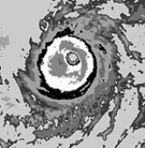
Typhoon Freda
Freda was the first tropical cyclone in the western Pacific in 1981 and the fourth typhoon to occur in March since 1959. The incipient disturbance was nearly stationary near the Gilbert IslandsGilbert Islands
The Gilbert Islands are a chain of sixteen atolls and coral islands in the Pacific Ocean. They are the main part of Republic of Kiribati and include Tarawa, the site of the country's capital and residence of almost half of the population.-Geography:The atolls and islands of the Gilbert Islands...
for a few days, before drifting northwest and slowly intensifying. During the morning of the March 11 it was upgraded to a tropical depression. It tracked along the periphery of the subtropical ridge
Subtropical ridge
The subtropical ridge is a significant belt of high pressure situated around the latitudes of 30°N in the Northern Hemisphere and 30°S in the Southern Hemisphere. It is characterized by mostly calm winds, which acts to reduce air quality under its axis by causing fog overnight, and haze during...
with slow development for the next few days. On March 14 intensification became more rapid and Freda became a typhoon. Passing 120 kilometres (74.6 mi) west of Wake Island
Wake Island
Wake Island is a coral atoll having a coastline of in the North Pacific Ocean, located about two-thirds of the way from Honolulu west to Guam east. It is an unorganized, unincorporated territory of the United States, administered by the Office of Insular Affairs, U.S. Department of the Interior...
with maximum sustained wind
Maximum sustained wind
The maximum sustained winds associated with a tropical cyclone are a common indicator of the intensity of the storm. Within a mature tropical cyclone, they are found within the eyewall at a distance defined as the radius of maximum wind, or RMW. Unlike gusts, the value of these winds are...
s of 100 knots (196 km/h) intensity, the island sustained wind gusts to typhoon force and waves to 6 metres (19.7 ft). As the typhoon moved more northeast, the cyclone weakened, and Freda was absorbed by March 17 into another extratropical cyclone
Extratropical cyclone
Extratropical cyclones, sometimes called mid-latitude cyclones or wave cyclones, are a group of cyclones defined as synoptic scale low pressure weather systems that occur in the middle latitudes of the Earth having neither tropical nor polar characteristics, and are connected with fronts and...
.
Tropical Storm Gerald
This cyclone initially formed in response to a mid to upper level cyclone southeast of PonapePohnpei
Not to be confused with Pompeii, the ancient city destroyed by Vesuvius in AD 79.Pohnpei "upon a stone altar " is the name of one of the four states in the Federated States of Micronesia , situated among the Senyavin Islands which are part of the larger Caroline Islands group...
on April 12. Thunderstorms developed near the upper level system, and an outflow pattern was present on satellite imagery, but a surface circulation did not materialize until April 15. The system became a tropical depression by that night. Steady intensification was seen until around midday on April 17 when a new upper level high formed to its east, inducing southerly vertical wind shear
Wind shear
Wind shear, sometimes referred to as windshear or wind gradient, is a difference in wind speed and direction over a relatively short distance in the atmosphere...
. Weakening began while the storm was located about 130 kilometres (80.8 mi) east of Guam
Guam
Guam is an organized, unincorporated territory of the United States located in the western Pacific Ocean. It is one of five U.S. territories with an established civilian government. Guam is listed as one of 16 Non-Self-Governing Territories by the Special Committee on Decolonization of the United...
late on April 18. Moderate to heavy rainfall did occur on the island, with 76.2 millimetres (3 in) to 127 millimetres (5 in) being measured. After passing Guam, the remaining thunderstorm activity sheared away, leaving a low-level swirl which moved northwest. The cyclone was absorbed by a system approaching in the main belt in the Westerlies on April 19.
Tropical Storm Holly
A broad area of thunderstorm straddled the equatorEquator
An equator is the intersection of a sphere's surface with the plane perpendicular to the sphere's axis of rotation and containing the sphere's center of mass....
around the International Date Line
International Date Line
The International Date Line is a generally north-south imaginary line on the surface of the Earth, passing through the middle of the Pacific Ocean, that designates the place where each calendar day begins...
beginning on April 21. A tropical system in the southern hemisphere
Southern Hemisphere
The Southern Hemisphere is the part of Earth that lies south of the equator. The word hemisphere literally means 'half ball' or "half sphere"...
was interacting with a strong system in the main belt of the Westerlies. Around this time, convective increased north of the equator, with a low level circulation forming near 4°N 169°E late on April 25. By midday on April 29 it had become a tropical depression as it continued to move westward. Holly became a tropical storm on April 30 and almost became a typhoon late on May 1. Southwesterly vertical wind shear
Wind shear
Wind shear, sometimes referred to as windshear or wind gradient, is a difference in wind speed and direction over a relatively short distance in the atmosphere...
began to weaken the cyclone thereafter, causing Holly to dissipate over the open Pacific ocean.
Typhoon Ike (Bining)
This cyclone formed in the South China SeaSouth China Sea
The South China Sea is a marginal sea that is part of the Pacific Ocean, encompassing an area from the Singapore and Malacca Straits to the Strait of Taiwan of around...
at the end of the monsoon
Monsoon
Monsoon is traditionally defined as a seasonal reversing wind accompanied by corresponding changes in precipitation, but is now used to describe seasonal changes in atmospheric circulation and precipitation associated with the asymmetric heating of land and sea...
transition season. Around noon on June 8 a broad area of lowered pressures was seen west of the Philippines
Philippines
The Philippines , officially known as the Republic of the Philippines , is a country in Southeast Asia in the western Pacific Ocean. To its north across the Luzon Strait lies Taiwan. West across the South China Sea sits Vietnam...
. Moderate northeast wind shear
Wind shear
Wind shear, sometimes referred to as windshear or wind gradient, is a difference in wind speed and direction over a relatively short distance in the atmosphere...
displaced its mid-level center as far as 110 kilometres (68.4 mi) from the surface center, which retarded development. By midday on June 9, Ike strengthened into a tropical storm. On its closest approach to Hong Kong, winds gusted to 42 knots (82.3 km/h) at Tate's Cairn.
An upper trough in the main belt of the Westerlies moved across Asia, which turned Ike to the northeast. Intensification continued as it accelerated, and Ike became a typhoon late on June 12. The cyclone reached its peak intensity as it made landfall on the island of Taiwan
Taiwan
Taiwan , also known, especially in the past, as Formosa , is the largest island of the same-named island group of East Asia in the western Pacific Ocean and located off the southeastern coast of mainland China. The island forms over 99% of the current territory of the Republic of China following...
. Weakening substantially over the mountainous island, Ike attempted slight tropical redevelopment before it became an extratropical cyclone
Extratropical cyclone
Extratropical cyclones, sometimes called mid-latitude cyclones or wave cyclones, are a group of cyclones defined as synoptic scale low pressure weather systems that occur in the middle latitudes of the Earth having neither tropical nor polar characteristics, and are connected with fronts and...
late on the morning of June 14. Eight perished due to Ike, four from Taiwan and four from the Philippines.
Typhoon June (Kuring)
A tropical upper tropospheric trough (TUTT) was located over the Philippine SeaPhilippine Sea
The Philippine Sea is a marginal sea east and north of the Philippines occupying an estimated surface area of 2 million mi² on the western part of the North Pacific Ocean...
early in June. In response, a tropical disturbance formed in Palau
Palau
Palau , officially the Republic of Palau , is an island nation in the Pacific Ocean, east of the Philippines and south of Tokyo. In 1978, after three decades as being part of the United Nations trusteeship, Palau chose independence instead of becoming part of the Federated States of Micronesia, a...
. An upper cyclone to the disturbance's northeast led to development of the disturbance. As the TUTT cell moved to the disturbance's northwest, intensification sped up and a low level circulation center formed on June 15 about 320 kilometres (198.8 mi) north of Palau. By the afternoon of June 17, the cyclone had become a tropical storm. June tracked northwest towards Taiwan
Taiwan
Taiwan , also known, especially in the past, as Formosa , is the largest island of the same-named island group of East Asia in the western Pacific Ocean and located off the southeastern coast of mainland China. The island forms over 99% of the current territory of the Republic of China following...
, and by late on June 19, had reached its maximum intensity as a typhoon. About 75 kilometres (46.6 mi) southeast of Taipei, June recurved to the north, and gradually weakened. While approaching Japan, the cyclone linked up with a frontal boundary and became an extratropical cyclone
Extratropical cyclone
Extratropical cyclones, sometimes called mid-latitude cyclones or wave cyclones, are a group of cyclones defined as synoptic scale low pressure weather systems that occur in the middle latitudes of the Earth having neither tropical nor polar characteristics, and are connected with fronts and...
late on June 22.
Typhoon Kelly (Daling)
A tropical disturbance organized into a tropical depression east of the Philippines on June 28. It tracked westward, reaching tropical storm on June 30 before hitting the central Philippines. Kelly weakened over the islands, but restrengthened in the South China SeaSouth China Sea
The South China Sea is a marginal sea that is part of the Pacific Ocean, encompassing an area from the Singapore and Malacca Straits to the Strait of Taiwan of around...
, attaining typhoon status on July 2. The typhoon hit southern Hainan Island on July 3, bringing wind gusts to 54 knots (105.8 km/h) at Tate's Cairn in Hong Kong. The cyclone then crossed the Gulf of Tonkin
Gulf of Tonkin
The Gulf of Tonkin is an arm of the South China Sea, lying off the coast of northeastern Vietnam.-Etymology:The name Tonkin, written "東京" in Hán tự and Đông Kinh in romanised Vietnamese, means "Eastern Capital", and is the former toponym for Hanoi, the capital of Vietnam...
as a weakening tropical storm, and made landfall on northern Vietnam
Vietnam
Vietnam – sometimes spelled Viet Nam , officially the Socialist Republic of Vietnam – is the easternmost country on the Indochina Peninsula in Southeast Asia. It is bordered by China to the north, Laos to the northwest, Cambodia to the southwest, and the South China Sea –...
on July 4 as a tropical storm with maximum sustained winds of 35 knots (68.6 km/h). Kelly dissipated the next day, after causing torrential flooding and mudslides, resulting in 200 casualties and leaving thousands homeless.
Tropical Storm Lynn (Elang)
On the morning of June 27, an area of enhanced thunderstorm activity was spotted just south of PonapePohnpei
Not to be confused with Pompeii, the ancient city destroyed by Vesuvius in AD 79.Pohnpei "upon a stone altar " is the name of one of the four states in the Federated States of Micronesia , situated among the Senyavin Islands which are part of the larger Caroline Islands group...
along a weak portion of the monsoon trough
Monsoon trough
The monsoon trough is that portion of the Intertropical Convergence Zone which extends into or through a monsoon circulation, as depicted by a line on a weather map showing the locations of minimum sea level pressure, and as such, is a convergence zone between the wind patterns of the southern and...
. As Tropical Storm Kelly led to some vertical wind shear
Wind shear
Wind shear, sometimes referred to as windshear or wind gradient, is a difference in wind speed and direction over a relatively short distance in the atmosphere...
over the system, the disturbance was slow to organize. A low pressure area formed late on June 29. By late on July 2, Kelly's negative influence on the disturbance abated, allowing for further development. Early on July 3, the system developed into a tropical depression, and by afternoon Lynn was a tropical storm. Previously moving at a fast pace to the west, the cyclone slowed as it passed by the northern fringe of the Philippines. Inflow from the South China Sea
South China Sea
The South China Sea is a marginal sea that is part of the Pacific Ocean, encompassing an area from the Singapore and Malacca Straits to the Strait of Taiwan of around...
led to convection focusing in the terrain of the Philippines, which distorted Lynn's convective pattern. Lynn was the second tropical cyclone is three days to impact the Philippines. The cyclone took 30 hours to track across the northern portion of the archipelago
Archipelago
An archipelago , sometimes called an island group, is a chain or cluster of islands. The word archipelago is derived from the Greek ἄρχι- – arkhi- and πέλαγος – pélagos through the Italian arcipelago...
.
It took until late on July 4 for the storm to recover from its Philippine interaction and redevelop a central dense overcast and quicken its pace to the west across Luzon. Turning northwest across the South China Sea, light to moderate easterly wind shear prevented Lynn's development into a typhoon. The cyclone struck Chuan-Tao, China early on July 7. Very heavy rainfall led to mudslides which took 22 lives and left tens of thousands homeless. In Hong Kong, winds gusted to 78 knots (152.9 km/h) at Tai O
Tai O
Tai O is a fishing town, partly located on an island of the same name, on the western side of Lantau Island in Hong Kong.-Geography:On the main part of Lantau Island, a river splits to the north and west and at this fork lies the island referred to as Tai O. Two pedestrian bridges cross the river...
, and a total of 118 millimetres (4.6 in) of rainfall was recorded at Cheung Chau.
Tropical Storm Maury (Huling)
On the morning of July 14, satellite imagery revealed an area of convection about 205 kilometres (127.4 mi) north-northwest of YapYap
Yap, also known as Wa'ab by locals, is an island in the Caroline Islands of the western Pacific Ocean. It is a state of the Federated States of Micronesia. Yap's indigenous cultures and traditions are still strong compared to other neighboring islands. The island of Yap actually consists of four...
. By late on July 16, a mid-level center has formed in association with the thunderstorm complex, which was moving northwest. Ship reports indicated the system had become a tropical storm by the morning of July 18. Southwesterly vertical wind shear
Wind shear
Wind shear, sometimes referred to as windshear or wind gradient, is a difference in wind speed and direction over a relatively short distance in the atmosphere...
impacted Maury, which led to its tilting to the northeast with height. By early on July 19 the wind shear lessened, and the cyclone's structure improved. While approaching China, a strong ridge to its northwest deflected the storm on a more westerly heading, sending the center toward Taiwan
Taiwan
Taiwan , also known, especially in the past, as Formosa , is the largest island of the same-named island group of East Asia in the western Pacific Ocean and located off the southeastern coast of mainland China. The island forms over 99% of the current territory of the Republic of China following...
. This ridge also led to weak east-northeasterly vertical wind shear, which halted development. By late on July 19, the cyclone's center moved ashore northern Taiwan. Heavy rains led to significant flooding and the loss of 38 lives. Moving through the Formosa Strait as a weak tropical storm, Maury made a second landfall near Fu-Chou, China on the morning of July 20. Its remains were dragged southwest by an upper cyclone to its southeast back into the Gulf of Tonkin
Gulf of Tonkin
The Gulf of Tonkin is an arm of the South China Sea, lying off the coast of northeastern Vietnam.-Etymology:The name Tonkin, written "東京" in Hán tự and Đông Kinh in romanised Vietnamese, means "Eastern Capital", and is the former toponym for Hanoi, the capital of Vietnam...
. By late on July 23, the circulation center moved back to the north near Yin-Chou, China and dissipated inland late on July 24. Its former thunderstorm activity decoupled from the surface center while still offshore and moved inland near Nam Dinh, Vietnam
Vietnam
Vietnam – sometimes spelled Viet Nam , officially the Socialist Republic of Vietnam – is the easternmost country on the Indochina Peninsula in Southeast Asia. It is bordered by China to the north, Laos to the northwest, Cambodia to the southwest, and the South China Sea –...
before dissipating over Laos
Laos
Laos Lao: ສາທາລະນະລັດ ປະຊາທິປະໄຕ ປະຊາຊົນລາວ Sathalanalat Paxathipatai Paxaxon Lao, officially the Lao People's Democratic Republic, is a landlocked country in Southeast Asia, bordered by Burma and China to the northwest, Vietnam to the east, Cambodia to the south and Thailand to the west...
late on July 24.
Tropical Storm Nina (Ibiang)
The eastern portion of the large convective mass from Maury led to Nina's formation. It was first noted late on July 20 to the east of TaiwanTaiwan
Taiwan , also known, especially in the past, as Formosa , is the largest island of the same-named island group of East Asia in the western Pacific Ocean and located off the southeastern coast of mainland China. The island forms over 99% of the current territory of the Republic of China following...
. As it moved northwest around northern Taiwan late on the morning of July 22. By late afternoon a surface low formed with enough convective activity to be designated a tropical depression. Moving northwest at 12 knots (23.5 km/h), the cyclone briefly became a tropical storm before nearly land and weakening back into a tropical depression. Early on the morning of July 23, its center made landfall northwest of Hsia-p'u, China before quickly dissipating in mountainous terrain inland.
Typhoon Ogden
An area of convection active for the previous 48 hours led to the formation of a low level circulation near 23°N 151°E early on July 27. Gradual intensification ensued, and the system developed into a tropical depression that evening, a tropical storm on July 28, and a typhoon by July 31 as it moved west-northwest. The cyclone struck southern Kyūshū, in Japan, early on July 31 which weakened the cyclone. The tropical storm then moved into the East China SeaEast China Sea
The East China Sea is a marginal sea east of China. It is a part of the Pacific Ocean and covers an area of 1,249,000 km² or 750,000 square miles.-Geography:...
which continuing to spin down. Upper level wind shear took its toll, leading to its weakening into a tropical depression and its ultimate dissipation in the Yellow Sea
Yellow Sea
The Yellow Sea is the name given to the northern part of the East China Sea, which is a marginal sea of the Pacific Ocean. It is located between mainland China and the Korean Peninsula. Its name comes from the sand particles from Gobi Desert sand storms that turn the surface of the water golden...
along the west coast of Korea.
Tropical Depression 11W
Both Tropical Depression 11W and Tropical Storm Phyllis were associated with the same synoptic scaleSynoptic scale meteorology
The synoptic scale in meteorology is a horizontal length scale of the order of 1000 kilometres or more. This corresponds to a horizontal scale typical of mid-latitude depressions...
feature, similar to Maury and Nina. On July 30 the monsoon trough
Monsoon trough
The monsoon trough is that portion of the Intertropical Convergence Zone which extends into or through a monsoon circulation, as depicted by a line on a weather map showing the locations of minimum sea level pressure, and as such, is a convergence zone between the wind patterns of the southern and...
extended from the Northern Marianas islands southeast toward Palau
Palau
Palau , officially the Republic of Palau , is an island nation in the Pacific Ocean, east of the Philippines and south of Tokyo. In 1978, after three decades as being part of the United Nations trusteeship, Palau chose independence instead of becoming part of the Federated States of Micronesia, a...
. Two circulations were at opposite ends of the trough. Tropical Depression 11W formed north of Guam late on July 31. Moving northeast, the tropical depression experienced vertical wind shear
Wind shear
Wind shear, sometimes referred to as windshear or wind gradient, is a difference in wind speed and direction over a relatively short distance in the atmosphere...
as the upper anticyclone fostering development accelerated faster than the tropical depression. This led to dissipation by late morning on August 2.
Tropical Storm Phyllis
A second circulation along the monsoon trough which spawned Tropical Depression 11 was noted north of Palau. By late on August 3 it had developed into Tropical Storm Phyllis. Tracking northward at 11 knots (21.6 km/h), the cyclone intensified slowly due to westerly vertical wind shear. Increased vertical wind shear from the southeast and cooler sea surface temperatureSea surface temperature
Sea surface temperature is the water temperature close to the oceans surface. The exact meaning of surface varies according to the measurement method used, but it is between and below the sea surface. Air masses in the Earth's atmosphere are highly modified by sea surface temperatures within a...
s led to the decline of Phyllis late on August 4, and it dissipated as a tropical cyclone early on August 5. Its remains tracked northeast, merging with an extratropical cyclone
Extratropical cyclone
Extratropical cyclones, sometimes called mid-latitude cyclones or wave cyclones, are a group of cyclones defined as synoptic scale low pressure weather systems that occur in the middle latitudes of the Earth having neither tropical nor polar characteristics, and are connected with fronts and...
offshore Japan. Eleven perished during Phyllis, with 22,500 people being left homeless across Japan.
Tropical Storm Roy (Miling)
The initial disturbance formed east of VietnamVietnam
Vietnam – sometimes spelled Viet Nam , officially the Socialist Republic of Vietnam – is the easternmost country on the Indochina Peninsula in Southeast Asia. It is bordered by China to the north, Laos to the northwest, Cambodia to the southwest, and the South China Sea –...
during the first few days of August. By August 2, a low level circulation was present. Moving slowly to the north, the low pressure area developed central convection. By late on August 4, the disturbance strengthened into a tropical depression before reaching tropical storm strength on August 5. Easterly shear began soon afterwards, and Roy's circulation center became exposed well to the east of the main convection. This caused its subsequent weakening and dissipation before reaching Hai-nan. Winds gusted to 41 knots (80.4 km/h) on the northwest side of Hong Kong's airport.
Tropical Storm Susan
The monsoon troughMonsoon trough
The monsoon trough is that portion of the Intertropical Convergence Zone which extends into or through a monsoon circulation, as depicted by a line on a weather map showing the locations of minimum sea level pressure, and as such, is a convergence zone between the wind patterns of the southern and...
became well-established along 20 degrees north
20th parallel north
The 20th parallel north is a circle of latitude that is 20 degrees north of the Earth's equatorial plane. It crosses Africa, Asia, the Indian Ocean, the Pacific Ocean, North America, the Caribbean and the Atlantic Ocean....
latitude. To the east of Phyllis, part of the monsoon trough shifted east towards Wake Island
Wake Island
Wake Island is a coral atoll having a coastline of in the North Pacific Ocean, located about two-thirds of the way from Honolulu west to Guam east. It is an unorganized, unincorporated territory of the United States, administered by the Office of Insular Affairs, U.S. Department of the Interior...
while the western portion moved north with Phyllis. Early on August 7, a tropical disturbance was noted about 110 kilometres (68.4 mi) north of Wake Island. During this time, Wake experienced gale-force winds and heavy rainfall. The low level center became exposed for a time, though gales continued. By late on August 8, convection at the edge of the surface low strengthened as the vertical wind shear
Wind shear
Wind shear, sometimes referred to as windshear or wind gradient, is a difference in wind speed and direction over a relatively short distance in the atmosphere...
weakened. At this point, the gale center was deemed to be a tropical cyclone, and was named Susan. The storm tracked north until reaching 30 degrees north
30th parallel north
The 30th parallel north is a circle of latitude that is 30 degrees north of the Earth's equatorial plane. It stands one-third of the way between the equator and the North Pole and crosses Africa, Asia, the Pacific Ocean, North America and the Atlantic Ocean....
latitude, before turning northwest towards a weak cold front. Early on August 11, Susan entrained cooler and drier air from behind the frontal zone which led to a significant reduction in thunderstorm activity. A warm core ridge building to its northeast forced the storm on a more west-northwest course, and as a second cold front approached, Susan recurved into the boundary, becoming an extratropical cyclone
Extratropical cyclone
Extratropical cyclones, sometimes called mid-latitude cyclones or wave cyclones, are a group of cyclones defined as synoptic scale low pressure weather systems that occur in the middle latitudes of the Earth having neither tropical nor polar characteristics, and are connected with fronts and...
during the late morning of August 13.
Typhoon Thad (Openg)
An active monsoon troughMonsoon trough
The monsoon trough is that portion of the Intertropical Convergence Zone which extends into or through a monsoon circulation, as depicted by a line on a weather map showing the locations of minimum sea level pressure, and as such, is a convergence zone between the wind patterns of the southern and...
spawned three tropical cyclones within 48 hours beginning on August 16. Thad was the first of the trio, initially noted on August 10 near 18°N 130°E. On August 15, limited outflow was witnessed over its low level circulation. The system developed into a tropical depression late on August 16. Thad moved north and northeast, maturing into a typhoon by late morning on August 18. On August 22 Thad accelerated northward between a subtropical ridge to its east and a deepening shortwave to its west, striking eastern Japan with a forward motion near 45 knots (88.2 km/h). Thereafter, the cyclone rapidly transitioned into an extratropical cyclone
Extratropical cyclone
Extratropical cyclones, sometimes called mid-latitude cyclones or wave cyclones, are a group of cyclones defined as synoptic scale low pressure weather systems that occur in the middle latitudes of the Earth having neither tropical nor polar characteristics, and are connected with fronts and...
by late on August 23. Twenty died during Thad's passage of Japan.
Tropical Storm Vanessa
This system developed about 110 kilometres (68.4 mi) south of Marcus Island near the merger of the monsoon troughMonsoon trough
The monsoon trough is that portion of the Intertropical Convergence Zone which extends into or through a monsoon circulation, as depicted by a line on a weather map showing the locations of minimum sea level pressure, and as such, is a convergence zone between the wind patterns of the southern and...
and a sharp surface trough brought into the region by Susan. Thunderstorm activity increased in the area on August 12, the next system up the monsoon trough
Monsoon trough
The monsoon trough is that portion of the Intertropical Convergence Zone which extends into or through a monsoon circulation, as depicted by a line on a weather map showing the locations of minimum sea level pressure, and as such, is a convergence zone between the wind patterns of the southern and...
from Thad. Once Vanessa freed itself from nearby troughs of low pressure, it lost one of its primary outflow channels and its northeastward movement subsequently exposed the system to the main belt of the westerlies. Within two days of formation as a tropical cyclone, Vanessa was already devoid of convection and transitioning to an extratropical cyclone
Extratropical cyclone
Extratropical cyclones, sometimes called mid-latitude cyclones or wave cyclones, are a group of cyclones defined as synoptic scale low pressure weather systems that occur in the middle latitudes of the Earth having neither tropical nor polar characteristics, and are connected with fronts and...
on the morning of August 19. The exposed surface circulation was tracked an additional couple days, merging with a mid-latitude system near 40°N 165°E on the morning of August 21.
Tropical Storm Warren
The initial disturbance which led to Warren's formation formed withini the monsoon troughMonsoon trough
The monsoon trough is that portion of the Intertropical Convergence Zone which extends into or through a monsoon circulation, as depicted by a line on a weather map showing the locations of minimum sea level pressure, and as such, is a convergence zone between the wind patterns of the southern and...
on August 14. Strong northeasterly wind shear halted further development for the next few days. By August 17 the vertical wind shear
Wind shear
Wind shear, sometimes referred to as windshear or wind gradient, is a difference in wind speed and direction over a relatively short distance in the atmosphere...
relaxed, and thunderstorms increased south of the center. Moving slowly westward, the system became a tropical storm on the afternoon of August 18. Warren tracked over Hai-nan island, and into the Gulf of Tonkin
Gulf of Tonkin
The Gulf of Tonkin is an arm of the South China Sea, lying off the coast of northeastern Vietnam.-Etymology:The name Tonkin, written "東京" in Hán tự and Đông Kinh in romanised Vietnamese, means "Eastern Capital", and is the former toponym for Hanoi, the capital of Vietnam...
. Intensification renewed, but maximum sustained winds leveled off at 45 knots (88.2 km/h). The cyclone made its final landfall near Nam Dinh, Vietnam
Vietnam
Vietnam – sometimes spelled Viet Nam , officially the Socialist Republic of Vietnam – is the easternmost country on the Indochina Peninsula in Southeast Asia. It is bordered by China to the north, Laos to the northwest, Cambodia to the southwest, and the South China Sea –...
on August 20 and dissipated rapidly that evening.
Typhoon Agnes (Pining)
On August 23, a well-defined Tropical Upper Tropospheric Trough moved westward from the International Date LineInternational Date Line
The International Date Line is a generally north-south imaginary line on the surface of the Earth, passing through the middle of the Pacific Ocean, that designates the place where each calendar day begins...
. On August 24, a surface cyclone developed in its vicinity near Wake Island
Wake Island
Wake Island is a coral atoll having a coastline of in the North Pacific Ocean, located about two-thirds of the way from Honolulu west to Guam east. It is an unorganized, unincorporated territory of the United States, administered by the Office of Insular Affairs, U.S. Department of the Interior...
. An extensive area of disorganized thunderstorm activity developed on its southwest side initially. As the convection moved westward, upper level outflow improved northeast of Guam
Guam
Guam is an organized, unincorporated territory of the United States located in the western Pacific Ocean. It is one of five U.S. territories with an established civilian government. Guam is listed as one of 16 Non-Self-Governing Territories by the Special Committee on Decolonization of the United...
. A well-defined mid-level cyclone passed just north of the island on the morning of August 26. A low level center began to form as the area moved northwest of Guam. By the early morning of August 27, a tropical depression had formed about 600 kilometres (372.8 mi) west-northwest of Guam. Development continued, and the system became a tropical storm that evening. Moving west-northwestward, Agnes became a typhoon on the morning of August 29. The following day, the intensifying typhoon passed 165 kilometres (102.5 mi) southwest of Okinawa. Entering a region of hostile northerly vertical wind shear
Wind shear
Wind shear, sometimes referred to as windshear or wind gradient, is a difference in wind speed and direction over a relatively short distance in the atmosphere...
, Agnes began to weaken. Its central convection was almost completely gone by the morning of September 2. Agnes remained well south of Korea until September 3, when it unleashed a torrent of rainfall, the heaviest of the 20th century up to that time, when 711.2 millimetres (28 in) fell upon the peninsula. Agnes' remains passed through the Korea Strait
Korea Strait
The Korea Strait is a sea passage between South Korea and Japan, connecting the East China Sea and the Sea of Japan in the northwest Pacific Ocean...
into the Sea of Japan
Sea of Japan
The Sea of Japan is a marginal sea of the western Pacific Ocean, between the Asian mainland, the Japanese archipelago and Sakhalin. It is bordered by Japan, North Korea, Russia and South Korea. Like the Mediterranean Sea, it has almost no tides due to its nearly complete enclosure from the Pacific...
by September 4. A total of 139 lives were taken by Agnes.
Typhoon Bill
The initial disturbance formed about 550 kilometres (341.8 mi) east-southeast of Marcus Island on September 1. A compact system, with an area of central convection 280 kilometres (174 mi) wide, Bill rapidly spun up into a tropical storm on September 3, and typhoon on September 4. Its central pressure was quite high for winds of that intensity due to the pressure gradient between the cyclone and the subtropical ridge to its northeast. The typhoon followed a classic parabolic track around the periphery of the subtropical ridgeSubtropical ridge
The subtropical ridge is a significant belt of high pressure situated around the latitudes of 30°N in the Northern Hemisphere and 30°S in the Southern Hemisphere. It is characterized by mostly calm winds, which acts to reduce air quality under its axis by causing fog overnight, and haze during...
east of Japan, weakening back into a tropical storm on September 7. Rapid extratropical transition occurred as Bill interacted with the main belt of the Westerlies, and by midnight, Bill became an extratropical cyclone
Extratropical cyclone
Extratropical cyclones, sometimes called mid-latitude cyclones or wave cyclones, are a group of cyclones defined as synoptic scale low pressure weather systems that occur in the middle latitudes of the Earth having neither tropical nor polar characteristics, and are connected with fronts and...
.
Typhoon Clara (Rubing)
The monsoon troughMonsoon trough
The monsoon trough is that portion of the Intertropical Convergence Zone which extends into or through a monsoon circulation, as depicted by a line on a weather map showing the locations of minimum sea level pressure, and as such, is a convergence zone between the wind patterns of the southern and...
spawned a tropical depression on September 13 well east of the Philippines. The depression moved to the west-northwest, strengthening into a tropical storm on September 16 and a typhoon on September 18. Clara rapidly intensified to peak winds of 120 knots (235.2 km/h) on September 19 before brushing northern Luzon
Luzon
Luzon is the largest island in the Philippines. It is located in the northernmost region of the archipelago, and is also the name for one of the three primary island groups in the country centered on the Island of Luzon...
. Its circulation disrupted, Clara steadily weakened as it continued to the northwest, hitting southeast China on the 21st as a typhoon with winds of 70 knots (137.2 km/h). In Hong Kong, winds gusted to 51 knots (100 km/h) at Cheung Chau. Clara caused extensive damage and 141 deaths, leaving thousands homeless from the heavy rains.
Typhoon Doyle
Like Bill, Doyle was a midget typhoon that spent its life out over the open Pacific ocean. Its initial disturbance was first detected near 25°N 178°E on September 18. The cyclone built down to the surface while moving westward, and Doyle became a tropical storm on the afternoon of September 20 and a typhoon the following day. Recurving around the subtropical ridgeSubtropical ridge
The subtropical ridge is a significant belt of high pressure situated around the latitudes of 30°N in the Northern Hemisphere and 30°S in the Southern Hemisphere. It is characterized by mostly calm winds, which acts to reduce air quality under its axis by causing fog overnight, and haze during...
, Doyle accelerated rapidly northeastward, weakening over cool waters as it was merging with a frontal zone and becoming an extratropical cyclone
Extratropical cyclone
Extratropical cyclones, sometimes called mid-latitude cyclones or wave cyclones, are a group of cyclones defined as synoptic scale low pressure weather systems that occur in the middle latitudes of the Earth having neither tropical nor polar characteristics, and are connected with fronts and...
during the early morning of September 24 near 39°N 172°E.
Super Typhoon Elsie (Tasing)
The monsoon troughMonsoon trough
The monsoon trough is that portion of the Intertropical Convergence Zone which extends into or through a monsoon circulation, as depicted by a line on a weather map showing the locations of minimum sea level pressure, and as such, is a convergence zone between the wind patterns of the southern and...
became diffuse on September 19 and September 20 in the wake of Typhoons Clara and Doyle. A small thunderstorm area formed near 8°N 150°E late on the morning of September 22, which slowly developed into a tropical depression early on September 25. Development was steady into a tropical storm later that day, a typhoon on the morning of September 26, and a super typhoon during the afternoon of September 27, maintaining that intensity into September 30. Elsie moved on a parabolic curve around the subtropical ridge to its northeast and east, moving offshore Japan as a typhoon on October 1 and October 2. By October 2, interaction with the upper trough which led to its recurvature also transitioned the typhoon into an extratropical cyclone
Extratropical cyclone
Extratropical cyclones, sometimes called mid-latitude cyclones or wave cyclones, are a group of cyclones defined as synoptic scale low pressure weather systems that occur in the middle latitudes of the Earth having neither tropical nor polar characteristics, and are connected with fronts and...
.
Tropical Storm Fabian (Unsing)
An area of active yet disorganized thunderstorm activity was located northeast of PalauPalau
Palau , officially the Republic of Palau , is an island nation in the Pacific Ocean, east of the Philippines and south of Tokyo. In 1978, after three decades as being part of the United Nations trusteeship, Palau chose independence instead of becoming part of the Federated States of Micronesia, a...
on October 6. Moving westward over the next several days, there was little change in organization until is approached Samar Island
Samar Island
Samar is an island in the Visayas, within the central Philippines. The island is divided into three provinces: Samar province, Northern Samar, and Eastern Samar. These three provinces, along with the provinces on the nearby islands of Leyte and Biliran are part of the Eastern Visayas region...
. Passing over the Philippines, it lost what convection it did have near the center, yet let to very heavy rainfall and flooding though a surface circulation was not apparent. Once the disturbance entered the South China Sea
South China Sea
The South China Sea is a marginal sea that is part of the Pacific Ocean, encompassing an area from the Singapore and Malacca Straits to the Strait of Taiwan of around...
, it redeveloped and reached tropical depression strength on the afternoon of October 13. It crossed the sea and struck Cam Ranh Bay, Vietnam
Vietnam
Vietnam – sometimes spelled Viet Nam , officially the Socialist Republic of Vietnam – is the easternmost country on the Indochina Peninsula in Southeast Asia. It is bordered by China to the north, Laos to the northwest, Cambodia to the southwest, and the South China Sea –...
. By October 15, the cyclone had dissipated inland.
Typhoon Gay (Walding)
The system formed within a very large area of thunderstorm activity. The system originally had a large circulation center, which led to problems in fixing its center via satellite imagery. The development of a large eye on October 20 finally led to the tracking of a more definitive, well-defined, circulation center. The typhoon brought relief to drought conditions in Okinawa, when 150 millimetres (5.9 in) of rainfall fell there are the circulation center of Gay moved by about 175 kilometres (108.7 mi) to their southeast. As it continued moving towards Japan, the center passed only 50 kilometres (31.1 mi) from Tokyo, bringing significant rainfall to central portions of the island archipelagoArchipelago
An archipelago , sometimes called an island group, is a chain or cluster of islands. The word archipelago is derived from the Greek ἄρχι- – arkhi- and πέλαγος – pélagos through the Italian arcipelago...
. The typhoon ultimately merged with a second low pressure system moving eastward to the north of Japan.
Tropical Depression
This system was recognized by the Hong Kong Royal Observatory. A tropical depression formed in the South China Sea on November 10, and moved inland into Vietnam the following day.Typhoon Hazen (Yeyeng)
A tropical disturbance developed along a trough east of GuamGuam
Guam is an organized, unincorporated territory of the United States located in the western Pacific Ocean. It is one of five U.S. territories with an established civilian government. Guam is listed as one of 16 Non-Self-Governing Territories by the Special Committee on Decolonization of the United...
. Its circulation improved, and a low pressure center formed on November 13. It became a tropical depression by the morning of November 14, and a tropical storm that evening. Moving on a general westward track across the western Pacific, it moved over northern Saipan
Saipan
Saipan is the largest island of the United States Commonwealth of the Northern Mariana Islands , a chain of 15 tropical islands belonging to the Marianas archipelago in the western Pacific Ocean with a total area of . The 2000 census population was 62,392...
on the afternoon of November 15, bringing gusts approaching typhoon force. Hazen moved about 110 kilometres (68.4 mi) north of Guam
Guam
Guam is an organized, unincorporated territory of the United States located in the western Pacific Ocean. It is one of five U.S. territories with an established civilian government. Guam is listed as one of 16 Non-Self-Governing Territories by the Special Committee on Decolonization of the United...
before reaching typhoon strength on early on November 16. Its intensity fluctuated on November 17 and November 18 as Hazen interacted with a nearby frontal zone. Weakening as it neared the Philippines, Hazen moved just south of Catanduanes Island
Catanduanes Island
Catanduanes Island is the main island of Catanduanes Province. It lies east of the Bicol Peninsula. The island is bounded by the Maqueda Channel in the west, the Pacific Ocean on the north and east, and Lagonoy Gulf and Cabugao Bay on the south....
, entering the South China Sea
South China Sea
The South China Sea is a marginal sea that is part of the Pacific Ocean, encompassing an area from the Singapore and Malacca Straits to the Strait of Taiwan of around...
. Never recovering from the mountainous archipelago, Hazen struck Vietnam
Vietnam
Vietnam – sometimes spelled Viet Nam , officially the Socialist Republic of Vietnam – is the easternmost country on the Indochina Peninsula in Southeast Asia. It is bordered by China to the north, Laos to the northwest, Cambodia to the southwest, and the South China Sea –...
about 280 kilometres (174 mi) east-northeast of Hanoi, and dissipated as it entered southeast China.
Super Typhoon Irma (Anding)
Super Typhoon Irma developed from the near-equatorial trough on November 17. As a tropical depression, it headed westward, and steadily intensified, first to a tropical storm on November 19, later to a typhoon on November 20. Irma quickly strengthened on November 22 to a super typhoon with maximum winds of 135 knots (264.6 km/h), but its outflow was disrupted by the Philippines to the southwest. Irma hit the northern Philippines on November 24 with maximum sustained winds of 85 knots (166.6 km/h), and rapidly weakened over the country. As a weakened tropical storm, Irma turned northeastward, where it was absorbed by a cold front on November 27. A total of 409 fatalities and $9 million in damage (1981 USD) can be attributed to the typhoon.Tropical Storm Jeff (Binang)
A distinct surface circulation formed by November 18. Jeff became a tropical storm on November 23 on the heels of Irma and approaching GuamGuam
Guam is an organized, unincorporated territory of the United States located in the western Pacific Ocean. It is one of five U.S. territories with an established civilian government. Guam is listed as one of 16 Non-Self-Governing Territories by the Special Committee on Decolonization of the United...
. It navigating through a break in the subtropical ridge
Subtropical ridge
The subtropical ridge is a significant belt of high pressure situated around the latitudes of 30°N in the Northern Hemisphere and 30°S in the Southern Hemisphere. It is characterized by mostly calm winds, which acts to reduce air quality under its axis by causing fog overnight, and haze during...
and dissipated over cooler waters on November 26 due to increasing vertical wind shear
Wind shear
Wind shear, sometimes referred to as windshear or wind gradient, is a difference in wind speed and direction over a relatively short distance in the atmosphere...
well to the south of Japan.
Typhoon Kit (Kadiang)
A strong and long lived tropical cyclone for December, the initial low level center for the system formed southwest of PonapePohnpei
Not to be confused with Pompeii, the ancient city destroyed by Vesuvius in AD 79.Pohnpei "upon a stone altar " is the name of one of the four states in the Federated States of Micronesia , situated among the Senyavin Islands which are part of the larger Caroline Islands group...
on December 4. By December 7, it had moved southwest of Truk without further development. By the morning of December 10, its structure was improving, and by the next afternoon a tropical depressions had formed. Late on December 11, it had evolved into a tropical storm. A slow moving system, Kit shifted from the northwest to a westerly heading, passing just south of Guam
Guam
Guam is an organized, unincorporated territory of the United States located in the western Pacific Ocean. It is one of five U.S. territories with an established civilian government. Guam is listed as one of 16 Non-Self-Governing Territories by the Special Committee on Decolonization of the United...
without any further development. Intensification resumed on the following two days reaching its first peak in intensity on December 16. The storm moved sharply northward for a second time at a slow rate of motion before resuming its westward motion due to a northeast surge in the trade winds. Reintensification occurred as the upper trough to its north acted as an outflow channel. Kit reached its peak intensity on the evening of December 17 before increasing westerlies aloft began to weaken the cyclone. On December 20, the surface circulation began to emerge south of its central convection. Thereafter, Kit was steered the low-level flow to the south and southwest as a deck of stratocumulus. On December 21. Kit became a tropical depression once more and by afternoon no longer qualified as a tropical cyclone
Tropical cyclone
A tropical cyclone is a storm system characterized by a large low-pressure center and numerous thunderstorms that produce strong winds and heavy rain. Tropical cyclones strengthen when water evaporated from the ocean is released as the saturated air rises, resulting in condensation of water vapor...
. Late on December 22, the low level cloud swirl moved into Mindanao
Mindanao
Mindanao is the second largest and easternmost island in the Philippines. It is also the name of one of the three island groups in the country, which consists of the island of Mindanao and smaller surrounding islands. The other two are Luzon and the Visayas. The island of Mindanao is called The...
before dissipating.
Typhoon Lee (Dinang)
While Kit was dissipating in the western Philippine SeaPhilippine Sea
The Philippine Sea is a marginal sea east and north of the Philippines occupying an estimated surface area of 2 million mi² on the western part of the North Pacific Ocean...
on December 21, a disturbed area of weather organized west of Truk. Strong northerlies previously diverted into Kit closed off a portion of the monsoon trough
Monsoon trough
The monsoon trough is that portion of the Intertropical Convergence Zone which extends into or through a monsoon circulation, as depicted by a line on a weather map showing the locations of minimum sea level pressure, and as such, is a convergence zone between the wind patterns of the southern and...
, with near gale-force winds wrapping around the convection. Development continued, and by the afternoon of December 22, the system became classified as a tropical depression. Tropical storm status was achieved that night. Moving west-northwest, Lee intensified rapidly into a typhoon on December 23 and reaching its peak intensity by December 24. Rapid weakening began as Lee crossed the Philippines, and the cyclone was once again a tropical storm by December 25. On December 28, all of the cyclone's convection was removed well east of the circulation center due to moderate to strong westerly vertical wind shear
Wind shear
Wind shear, sometimes referred to as windshear or wind gradient, is a difference in wind speed and direction over a relatively short distance in the atmosphere...
. Turning to the north, Lee dissipated as a tropical cyclone around 280 kilometres (174 mi) south of Hong Kong. A total of 188 perished during the cyclone's passage.
Other storms
Five additional tropical depressions were not named as tropical storms by the Joint Typhoon Warning Center (JTWC). They were, however, designated as tropical cyclones by the Philippines (PAGASA) once they entered the Philippine area of responsibility.- Tropical Depression Atring (February 14-February 16)
- Tropical Depression Goring (July 7-July 9)
- Tropical Depression Luming (July 30-August 1)
- Tropical Depression Narsing (August 8-August 9)
- Tropical Depression Saling (September 24-September 26)
Storm names
Western North Pacific tropical cyclones were named by the Joint Typhoon Warning CenterJoint Typhoon Warning Center
The Joint Typhoon Warning Center is a joint United States Navy – United States Air Force task force located at the Naval Maritime Forecast Center in Pearl Harbor, Hawaii...
. The first storm of 1981 was named Freda and the final one was named Lee. The name Hazen was removed from the list after this season for unknown reasons.
{|width="90%"
|
The 1981 Pacific typhoon season has no official bounds; it ran year-round in 1981, but most tropical cyclones tend to form in the northwestern Pacific Ocean between May and November. These dates conventionally delimit the period of each year when most tropical cyclones form in the northwestern Pacific Ocean. Tropical Storms formed in the entire west pacific basin were assigned a name by the Joint Typhoon Warning Center
Joint Typhoon Warning Center
The Joint Typhoon Warning Center is a joint United States Navy – United States Air Force task force located at the Naval Maritime Forecast Center in Pearl Harbor, Hawaii...
. Tropical depressions that enter or form in the Philippine area of responsibility are assigned a name by the Philippine Atmospheric, Geophysical and Astronomical Services Administration
Philippine Atmospheric, Geophysical and Astronomical Services Administration
The Philippine Atmospheric, Geophysical and Astronomical Services Administration is a Philippine national institution dedicated to provide flood and typhoon warnings, public weather forecasts and advisories, meteorological, astronomical, climatological, and other specialized information and...
or PAGASA. This can often result in the same storm having two names.
A total of 29 tropical depressions formed this year in the Western Pacific, of which 28 became tropical storms. Of the 29, 16 storms reached typhoon intensity, of which 2 reached super typhoon strength. Seven tropical cyclones moved through the Philippines this season. The first tropical cyclone formed on March 11, with the final tropical cyclone dissipating December 28. Tropical cyclones only accounted for 12 percent of the rainfall in Hong Kong this season, the lowest percentage for the protectorate since 1972.
Season summary
The season started with Freda, which became the fourth March typhoon for the basin since 1959. The system passed west of Wake Island before dissipating on March 17. Gerald formed in mid-April near an upper level low, and recurved just east of Guam bringing the island heavy rainfall. Holly formed in the middle of the tropical Pacific ocean in late April, and dissipated far from land on May 7. Ike was the first system to form in the South China Sea, living during the second week of June before recurving across Taiwan and becoming an extratropical cycloneExtratropical cyclone
Extratropical cyclones, sometimes called mid-latitude cyclones or wave cyclones, are a group of cyclones defined as synoptic scale low pressure weather systems that occur in the middle latitudes of the Earth having neither tropical nor polar characteristics, and are connected with fronts and...
. June formed during the third week of June, and moved just east of Taiwan before approaching Japan as a nontropical cyclone. Kelly crossed the Philippines on July 1, moving into Vietnam on July 4. Lynn moved nearby the northern Philippines before making landfall in mainland China on July 7. Maury tracked near Taiwan, China, and eventually Vietnam as a remnant low during the third and fourth weeks of July. Nina formed on the northeast fringe of Maury, also moving into mainland China on July 23, three days after Maury. Ogden moved into Japan at the end of July, approaching Korea early in August.
Tropical Depression 11 formed in the tropical west Pacific, dissipating well east of Asia on August 2. Phyllis formed and remained southeast of Japan on August 3 and August 4. Roy meandered around the South China Sea between August 3 and August 9. Susan moved northwest through the open western Pacific during the second week of August. Thad moved north-northeast through its life cycle, moving through Japan on August 23. Vanessa moved northeast through the open western Pacific in mid-August. Warren moved west-northwest through Hainan Island and northern Vietnam during the third week of August. Agnes moved extremely close to eastern China before dissipating on September 1. Bill recurved southeast of Japan during the first week of September. Clara moved west-northwest near Luzon and into mainland China during the third week of September.
Doyle moved through the central Pacific during the third week of September. Elsie recurved south of Japan during the beginning of October. Fabian moved westward through the Philippines into Vietnam during the second week of October. Gay recurved near the Japanese coast on October 21 and 22. A tropical depression moved west-northwest into Vietnam on November 11. Hazen moved across the Central Philippines into mainland China by November 23. Irma moved across the northern Philippines and then south of Taiwan during late November. Jeff recurved east of mainland Asia during late November. Kit moved erratically westward towards the Philippines during mid-December. Lee moved across the central Philippines, dissipating across the South China Sea on December 28.
Typhoon Freda
Freda was the first tropical cyclone in the western Pacific in 1981 and the fourth typhoon to occur in March since 1959. The incipient disturbance was nearly stationary near the Gilbert IslandsGilbert Islands
The Gilbert Islands are a chain of sixteen atolls and coral islands in the Pacific Ocean. They are the main part of Republic of Kiribati and include Tarawa, the site of the country's capital and residence of almost half of the population.-Geography:The atolls and islands of the Gilbert Islands...
for a few days, before drifting northwest and slowly intensifying. During the morning of the March 11 it was upgraded to a tropical depression. It tracked along the periphery of the subtropical ridge
Subtropical ridge
The subtropical ridge is a significant belt of high pressure situated around the latitudes of 30°N in the Northern Hemisphere and 30°S in the Southern Hemisphere. It is characterized by mostly calm winds, which acts to reduce air quality under its axis by causing fog overnight, and haze during...
with slow development for the next few days. On March 14 intensification became more rapid and Freda became a typhoon. Passing 120 kilometres (74.6 mi) west of Wake Island
Wake Island
Wake Island is a coral atoll having a coastline of in the North Pacific Ocean, located about two-thirds of the way from Honolulu west to Guam east. It is an unorganized, unincorporated territory of the United States, administered by the Office of Insular Affairs, U.S. Department of the Interior...
with maximum sustained wind
Maximum sustained wind
The maximum sustained winds associated with a tropical cyclone are a common indicator of the intensity of the storm. Within a mature tropical cyclone, they are found within the eyewall at a distance defined as the radius of maximum wind, or RMW. Unlike gusts, the value of these winds are...
s of 100 knots (196 km/h) intensity, the island sustained wind gusts to typhoon force and waves to 6 metres (19.7 ft). As the typhoon moved more northeast, the cyclone weakened, and Freda was absorbed by March 17 into another extratropical cyclone
Extratropical cyclone
Extratropical cyclones, sometimes called mid-latitude cyclones or wave cyclones, are a group of cyclones defined as synoptic scale low pressure weather systems that occur in the middle latitudes of the Earth having neither tropical nor polar characteristics, and are connected with fronts and...
.
Tropical Storm Gerald
This cyclone initially formed in response to a mid to upper level cyclone southeast of PonapePohnpei
Not to be confused with Pompeii, the ancient city destroyed by Vesuvius in AD 79.Pohnpei "upon a stone altar " is the name of one of the four states in the Federated States of Micronesia , situated among the Senyavin Islands which are part of the larger Caroline Islands group...
on April 12. Thunderstorms developed near the upper level system, and an outflow pattern was present on satellite imagery, but a surface circulation did not materialize until April 15. The system became a tropical depression by that night. Steady intensification was seen until around midday on April 17 when a new upper level high formed to its east, inducing southerly vertical wind shear
Wind shear
Wind shear, sometimes referred to as windshear or wind gradient, is a difference in wind speed and direction over a relatively short distance in the atmosphere...
. Weakening began while the storm was located about 130 kilometres (80.8 mi) east of Guam
Guam
Guam is an organized, unincorporated territory of the United States located in the western Pacific Ocean. It is one of five U.S. territories with an established civilian government. Guam is listed as one of 16 Non-Self-Governing Territories by the Special Committee on Decolonization of the United...
late on April 18. Moderate to heavy rainfall did occur on the island, with 76.2 millimetres (3 in) to 127 millimetres (5 in) being measured. After passing Guam, the remaining thunderstorm activity sheared away, leaving a low-level swirl which moved northwest. The cyclone was absorbed by a system approaching in the main belt in the Westerlies on April 19.
Tropical Storm Holly
A broad area of thunderstorm straddled the equatorEquator
An equator is the intersection of a sphere's surface with the plane perpendicular to the sphere's axis of rotation and containing the sphere's center of mass....
around the International Date Line
International Date Line
The International Date Line is a generally north-south imaginary line on the surface of the Earth, passing through the middle of the Pacific Ocean, that designates the place where each calendar day begins...
beginning on April 21. A tropical system in the southern hemisphere
Southern Hemisphere
The Southern Hemisphere is the part of Earth that lies south of the equator. The word hemisphere literally means 'half ball' or "half sphere"...
was interacting with a strong system in the main belt of the Westerlies. Around this time, convective increased north of the equator, with a low level circulation forming near 4°N 169°E late on April 25. By midday on April 29 it had become a tropical depression as it continued to move westward. Holly became a tropical storm on April 30 and almost became a typhoon late on May 1. Southwesterly vertical wind shear
Wind shear
Wind shear, sometimes referred to as windshear or wind gradient, is a difference in wind speed and direction over a relatively short distance in the atmosphere...
began to weaken the cyclone thereafter, causing Holly to dissipate over the open Pacific ocean.
Typhoon Ike (Bining)
This cyclone formed in the South China SeaSouth China Sea
The South China Sea is a marginal sea that is part of the Pacific Ocean, encompassing an area from the Singapore and Malacca Straits to the Strait of Taiwan of around...
at the end of the monsoon
Monsoon
Monsoon is traditionally defined as a seasonal reversing wind accompanied by corresponding changes in precipitation, but is now used to describe seasonal changes in atmospheric circulation and precipitation associated with the asymmetric heating of land and sea...
transition season. Around noon on June 8 a broad area of lowered pressures was seen west of the Philippines
Philippines
The Philippines , officially known as the Republic of the Philippines , is a country in Southeast Asia in the western Pacific Ocean. To its north across the Luzon Strait lies Taiwan. West across the South China Sea sits Vietnam...
. Moderate northeast wind shear
Wind shear
Wind shear, sometimes referred to as windshear or wind gradient, is a difference in wind speed and direction over a relatively short distance in the atmosphere...
displaced its mid-level center as far as 110 kilometres (68.4 mi) from the surface center, which retarded development. By midday on June 9, Ike strengthened into a tropical storm. On its closest approach to Hong Kong, winds gusted to 42 knots (82.3 km/h) at Tate's Cairn.
An upper trough in the main belt of the Westerlies moved across Asia, which turned Ike to the northeast. Intensification continued as it accelerated, and Ike became a typhoon late on June 12. The cyclone reached its peak intensity as it made landfall on the island of Taiwan
Taiwan
Taiwan , also known, especially in the past, as Formosa , is the largest island of the same-named island group of East Asia in the western Pacific Ocean and located off the southeastern coast of mainland China. The island forms over 99% of the current territory of the Republic of China following...
. Weakening substantially over the mountainous island, Ike attempted slight tropical redevelopment before it became an extratropical cyclone
Extratropical cyclone
Extratropical cyclones, sometimes called mid-latitude cyclones or wave cyclones, are a group of cyclones defined as synoptic scale low pressure weather systems that occur in the middle latitudes of the Earth having neither tropical nor polar characteristics, and are connected with fronts and...
late on the morning of June 14. Eight perished due to Ike, four from Taiwan and four from the Philippines.
Typhoon June (Kuring)
A tropical upper tropospheric trough (TUTT) was located over the Philippine SeaPhilippine Sea
The Philippine Sea is a marginal sea east and north of the Philippines occupying an estimated surface area of 2 million mi² on the western part of the North Pacific Ocean...
early in June. In response, a tropical disturbance formed in Palau
Palau
Palau , officially the Republic of Palau , is an island nation in the Pacific Ocean, east of the Philippines and south of Tokyo. In 1978, after three decades as being part of the United Nations trusteeship, Palau chose independence instead of becoming part of the Federated States of Micronesia, a...
. An upper cyclone to the disturbance's northeast led to development of the disturbance. As the TUTT cell moved to the disturbance's northwest, intensification sped up and a low level circulation center formed on June 15 about 320 kilometres (198.8 mi) north of Palau. By the afternoon of June 17, the cyclone had become a tropical storm. June tracked northwest towards Taiwan
Taiwan
Taiwan , also known, especially in the past, as Formosa , is the largest island of the same-named island group of East Asia in the western Pacific Ocean and located off the southeastern coast of mainland China. The island forms over 99% of the current territory of the Republic of China following...
, and by late on June 19, had reached its maximum intensity as a typhoon. About 75 kilometres (46.6 mi) southeast of Taipei, June recurved to the north, and gradually weakened. While approaching Japan, the cyclone linked up with a frontal boundary and became an extratropical cyclone
Extratropical cyclone
Extratropical cyclones, sometimes called mid-latitude cyclones or wave cyclones, are a group of cyclones defined as synoptic scale low pressure weather systems that occur in the middle latitudes of the Earth having neither tropical nor polar characteristics, and are connected with fronts and...
late on June 22.
Typhoon Kelly (Daling)
A tropical disturbance organized into a tropical depression east of the Philippines on June 28. It tracked westward, reaching tropical storm on June 30 before hitting the central Philippines. Kelly weakened over the islands, but restrengthened in the South China SeaSouth China Sea
The South China Sea is a marginal sea that is part of the Pacific Ocean, encompassing an area from the Singapore and Malacca Straits to the Strait of Taiwan of around...
, attaining typhoon status on July 2. The typhoon hit southern Hainan Island on July 3, bringing wind gusts to 54 knots (105.8 km/h) at Tate's Cairn in Hong Kong. The cyclone then crossed the Gulf of Tonkin
Gulf of Tonkin
The Gulf of Tonkin is an arm of the South China Sea, lying off the coast of northeastern Vietnam.-Etymology:The name Tonkin, written "東京" in Hán tự and Đông Kinh in romanised Vietnamese, means "Eastern Capital", and is the former toponym for Hanoi, the capital of Vietnam...
as a weakening tropical storm, and made landfall on northern Vietnam
Vietnam
Vietnam – sometimes spelled Viet Nam , officially the Socialist Republic of Vietnam – is the easternmost country on the Indochina Peninsula in Southeast Asia. It is bordered by China to the north, Laos to the northwest, Cambodia to the southwest, and the South China Sea –...
on July 4 as a tropical storm with maximum sustained winds of 35 knots (68.6 km/h). Kelly dissipated the next day, after causing torrential flooding and mudslides, resulting in 200 casualties and leaving thousands homeless.
Tropical Storm Lynn (Elang)
On the morning of June 27, an area of enhanced thunderstorm activity was spotted just south of PonapePohnpei
Not to be confused with Pompeii, the ancient city destroyed by Vesuvius in AD 79.Pohnpei "upon a stone altar " is the name of one of the four states in the Federated States of Micronesia , situated among the Senyavin Islands which are part of the larger Caroline Islands group...
along a weak portion of the monsoon trough
Monsoon trough
The monsoon trough is that portion of the Intertropical Convergence Zone which extends into or through a monsoon circulation, as depicted by a line on a weather map showing the locations of minimum sea level pressure, and as such, is a convergence zone between the wind patterns of the southern and...
. As Tropical Storm Kelly led to some vertical wind shear
Wind shear
Wind shear, sometimes referred to as windshear or wind gradient, is a difference in wind speed and direction over a relatively short distance in the atmosphere...
over the system, the disturbance was slow to organize. A low pressure area formed late on June 29. By late on July 2, Kelly's negative influence on the disturbance abated, allowing for further development. Early on July 3, the system developed into a tropical depression, and by afternoon Lynn was a tropical storm. Previously moving at a fast pace to the west, the cyclone slowed as it passed by the northern fringe of the Philippines. Inflow from the South China Sea
South China Sea
The South China Sea is a marginal sea that is part of the Pacific Ocean, encompassing an area from the Singapore and Malacca Straits to the Strait of Taiwan of around...
led to convection focusing in the terrain of the Philippines, which distorted Lynn's convective pattern. Lynn was the second tropical cyclone is three days to impact the Philippines. The cyclone took 30 hours to track across the northern portion of the archipelago
Archipelago
An archipelago , sometimes called an island group, is a chain or cluster of islands. The word archipelago is derived from the Greek ἄρχι- – arkhi- and πέλαγος – pélagos through the Italian arcipelago...
.
It took until late on July 4 for the storm to recover from its Philippine interaction and redevelop a central dense overcast and quicken its pace to the west across Luzon. Turning northwest across the South China Sea, light to moderate easterly wind shear prevented Lynn's development into a typhoon. The cyclone struck Chuan-Tao, China early on July 7. Very heavy rainfall led to mudslides which took 22 lives and left tens of thousands homeless. In Hong Kong, winds gusted to 78 knots (152.9 km/h) at Tai O
Tai O
Tai O is a fishing town, partly located on an island of the same name, on the western side of Lantau Island in Hong Kong.-Geography:On the main part of Lantau Island, a river splits to the north and west and at this fork lies the island referred to as Tai O. Two pedestrian bridges cross the river...
, and a total of 118 millimetres (4.6 in) of rainfall was recorded at Cheung Chau.
Tropical Storm Maury (Huling)
On the morning of July 14, satellite imagery revealed an area of convection about 205 kilometres (127.4 mi) north-northwest of YapYap
Yap, also known as Wa'ab by locals, is an island in the Caroline Islands of the western Pacific Ocean. It is a state of the Federated States of Micronesia. Yap's indigenous cultures and traditions are still strong compared to other neighboring islands. The island of Yap actually consists of four...
. By late on July 16, a mid-level center has formed in association with the thunderstorm complex, which was moving northwest. Ship reports indicated the system had become a tropical storm by the morning of July 18. Southwesterly vertical wind shear
Wind shear
Wind shear, sometimes referred to as windshear or wind gradient, is a difference in wind speed and direction over a relatively short distance in the atmosphere...
impacted Maury, which led to its tilting to the northeast with height. By early on July 19 the wind shear lessened, and the cyclone's structure improved. While approaching China, a strong ridge to its northwest deflected the storm on a more westerly heading, sending the center toward Taiwan
Taiwan
Taiwan , also known, especially in the past, as Formosa , is the largest island of the same-named island group of East Asia in the western Pacific Ocean and located off the southeastern coast of mainland China. The island forms over 99% of the current territory of the Republic of China following...
. This ridge also led to weak east-northeasterly vertical wind shear, which halted development. By late on July 19, the cyclone's center moved ashore northern Taiwan. Heavy rains led to significant flooding and the loss of 38 lives. Moving through the Formosa Strait as a weak tropical storm, Maury made a second landfall near Fu-Chou, China on the morning of July 20. Its remains were dragged southwest by an upper cyclone to its southeast back into the Gulf of Tonkin
Gulf of Tonkin
The Gulf of Tonkin is an arm of the South China Sea, lying off the coast of northeastern Vietnam.-Etymology:The name Tonkin, written "東京" in Hán tự and Đông Kinh in romanised Vietnamese, means "Eastern Capital", and is the former toponym for Hanoi, the capital of Vietnam...
. By late on July 23, the circulation center moved back to the north near Yin-Chou, China and dissipated inland late on July 24. Its former thunderstorm activity decoupled from the surface center while still offshore and moved inland near Nam Dinh, Vietnam
Vietnam
Vietnam – sometimes spelled Viet Nam , officially the Socialist Republic of Vietnam – is the easternmost country on the Indochina Peninsula in Southeast Asia. It is bordered by China to the north, Laos to the northwest, Cambodia to the southwest, and the South China Sea –...
before dissipating over Laos
Laos
Laos Lao: ສາທາລະນະລັດ ປະຊາທິປະໄຕ ປະຊາຊົນລາວ Sathalanalat Paxathipatai Paxaxon Lao, officially the Lao People's Democratic Republic, is a landlocked country in Southeast Asia, bordered by Burma and China to the northwest, Vietnam to the east, Cambodia to the south and Thailand to the west...
late on July 24.
Tropical Storm Nina (Ibiang)
The eastern portion of the large convective mass from Maury led to Nina's formation. It was first noted late on July 20 to the east of TaiwanTaiwan
Taiwan , also known, especially in the past, as Formosa , is the largest island of the same-named island group of East Asia in the western Pacific Ocean and located off the southeastern coast of mainland China. The island forms over 99% of the current territory of the Republic of China following...
. As it moved northwest around northern Taiwan late on the morning of July 22. By late afternoon a surface low formed with enough convective activity to be designated a tropical depression. Moving northwest at 12 knots (23.5 km/h), the cyclone briefly became a tropical storm before nearly land and weakening back into a tropical depression. Early on the morning of July 23, its center made landfall northwest of Hsia-p'u, China before quickly dissipating in mountainous terrain inland.
Typhoon Ogden
An area of convection active for the previous 48 hours led to the formation of a low level circulation near 23°N 151°E early on July 27. Gradual intensification ensued, and the system developed into a tropical depression that evening, a tropical storm on July 28, and a typhoon by July 31 as it moved west-northwest. The cyclone struck southern Kyūshū, in Japan, early on July 31 which weakened the cyclone. The tropical storm then moved into the East China SeaEast China Sea
The East China Sea is a marginal sea east of China. It is a part of the Pacific Ocean and covers an area of 1,249,000 km² or 750,000 square miles.-Geography:...
which continuing to spin down. Upper level wind shear took its toll, leading to its weakening into a tropical depression and its ultimate dissipation in the Yellow Sea
Yellow Sea
The Yellow Sea is the name given to the northern part of the East China Sea, which is a marginal sea of the Pacific Ocean. It is located between mainland China and the Korean Peninsula. Its name comes from the sand particles from Gobi Desert sand storms that turn the surface of the water golden...
along the west coast of Korea.
Tropical Depression 11W
Both Tropical Depression 11W and Tropical Storm Phyllis were associated with the same synoptic scaleSynoptic scale meteorology
The synoptic scale in meteorology is a horizontal length scale of the order of 1000 kilometres or more. This corresponds to a horizontal scale typical of mid-latitude depressions...
feature, similar to Maury and Nina. On July 30 the monsoon trough
Monsoon trough
The monsoon trough is that portion of the Intertropical Convergence Zone which extends into or through a monsoon circulation, as depicted by a line on a weather map showing the locations of minimum sea level pressure, and as such, is a convergence zone between the wind patterns of the southern and...
extended from the Northern Marianas islands southeast toward Palau
Palau
Palau , officially the Republic of Palau , is an island nation in the Pacific Ocean, east of the Philippines and south of Tokyo. In 1978, after three decades as being part of the United Nations trusteeship, Palau chose independence instead of becoming part of the Federated States of Micronesia, a...
. Two circulations were at opposite ends of the trough. Tropical Depression 11W formed north of Guam late on July 31. Moving northeast, the tropical depression experienced vertical wind shear
Wind shear
Wind shear, sometimes referred to as windshear or wind gradient, is a difference in wind speed and direction over a relatively short distance in the atmosphere...
as the upper anticyclone fostering development accelerated faster than the tropical depression. This led to dissipation by late morning on August 2.
Tropical Storm Phyllis
A second circulation along the monsoon trough which spawned Tropical Depression 11 was noted north of Palau. By late on August 3 it had developed into Tropical Storm Phyllis. Tracking northward at 11 knots (21.6 km/h), the cyclone intensified slowly due to westerly vertical wind shear. Increased vertical wind shear from the southeast and cooler sea surface temperatureSea surface temperature
Sea surface temperature is the water temperature close to the oceans surface. The exact meaning of surface varies according to the measurement method used, but it is between and below the sea surface. Air masses in the Earth's atmosphere are highly modified by sea surface temperatures within a...
s led to the decline of Phyllis late on August 4, and it dissipated as a tropical cyclone early on August 5. Its remains tracked northeast, merging with an extratropical cyclone
Extratropical cyclone
Extratropical cyclones, sometimes called mid-latitude cyclones or wave cyclones, are a group of cyclones defined as synoptic scale low pressure weather systems that occur in the middle latitudes of the Earth having neither tropical nor polar characteristics, and are connected with fronts and...
offshore Japan. Eleven perished during Phyllis, with 22,500 people being left homeless across Japan.
Tropical Storm Roy (Miling)
The initial disturbance formed east of VietnamVietnam
Vietnam – sometimes spelled Viet Nam , officially the Socialist Republic of Vietnam – is the easternmost country on the Indochina Peninsula in Southeast Asia. It is bordered by China to the north, Laos to the northwest, Cambodia to the southwest, and the South China Sea –...
during the first few days of August. By August 2, a low level circulation was present. Moving slowly to the north, the low pressure area developed central convection. By late on August 4, the disturbance strengthened into a tropical depression before reaching tropical storm strength on August 5. Easterly shear began soon afterwards, and Roy's circulation center became exposed well to the east of the main convection. This caused its subsequent weakening and dissipation before reaching Hai-nan. Winds gusted to 41 knots (80.4 km/h) on the northwest side of Hong Kong's airport.
Tropical Storm Susan
The monsoon troughMonsoon trough
The monsoon trough is that portion of the Intertropical Convergence Zone which extends into or through a monsoon circulation, as depicted by a line on a weather map showing the locations of minimum sea level pressure, and as such, is a convergence zone between the wind patterns of the southern and...
became well-established along 20 degrees north
20th parallel north
The 20th parallel north is a circle of latitude that is 20 degrees north of the Earth's equatorial plane. It crosses Africa, Asia, the Indian Ocean, the Pacific Ocean, North America, the Caribbean and the Atlantic Ocean....
latitude. To the east of Phyllis, part of the monsoon trough shifted east towards Wake Island
Wake Island
Wake Island is a coral atoll having a coastline of in the North Pacific Ocean, located about two-thirds of the way from Honolulu west to Guam east. It is an unorganized, unincorporated territory of the United States, administered by the Office of Insular Affairs, U.S. Department of the Interior...
while the western portion moved north with Phyllis. Early on August 7, a tropical disturbance was noted about 110 kilometres (68.4 mi) north of Wake Island. During this time, Wake experienced gale-force winds and heavy rainfall. The low level center became exposed for a time, though gales continued. By late on August 8, convection at the edge of the surface low strengthened as the vertical wind shear
Wind shear
Wind shear, sometimes referred to as windshear or wind gradient, is a difference in wind speed and direction over a relatively short distance in the atmosphere...
weakened. At this point, the gale center was deemed to be a tropical cyclone, and was named Susan. The storm tracked north until reaching 30 degrees north
30th parallel north
The 30th parallel north is a circle of latitude that is 30 degrees north of the Earth's equatorial plane. It stands one-third of the way between the equator and the North Pole and crosses Africa, Asia, the Pacific Ocean, North America and the Atlantic Ocean....
latitude, before turning northwest towards a weak cold front. Early on August 11, Susan entrained cooler and drier air from behind the frontal zone which led to a significant reduction in thunderstorm activity. A warm core ridge building to its northeast forced the storm on a more west-northwest course, and as a second cold front approached, Susan recurved into the boundary, becoming an extratropical cyclone
Extratropical cyclone
Extratropical cyclones, sometimes called mid-latitude cyclones or wave cyclones, are a group of cyclones defined as synoptic scale low pressure weather systems that occur in the middle latitudes of the Earth having neither tropical nor polar characteristics, and are connected with fronts and...
during the late morning of August 13.
Typhoon Thad (Openg)
An active monsoon troughMonsoon trough
The monsoon trough is that portion of the Intertropical Convergence Zone which extends into or through a monsoon circulation, as depicted by a line on a weather map showing the locations of minimum sea level pressure, and as such, is a convergence zone between the wind patterns of the southern and...
spawned three tropical cyclones within 48 hours beginning on August 16. Thad was the first of the trio, initially noted on August 10 near 18°N 130°E. On August 15, limited outflow was witnessed over its low level circulation. The system developed into a tropical depression late on August 16. Thad moved north and northeast, maturing into a typhoon by late morning on August 18. On August 22 Thad accelerated northward between a subtropical ridge to its east and a deepening shortwave to its west, striking eastern Japan with a forward motion near 45 knots (88.2 km/h). Thereafter, the cyclone rapidly transitioned into an extratropical cyclone
Extratropical cyclone
Extratropical cyclones, sometimes called mid-latitude cyclones or wave cyclones, are a group of cyclones defined as synoptic scale low pressure weather systems that occur in the middle latitudes of the Earth having neither tropical nor polar characteristics, and are connected with fronts and...
by late on August 23. Twenty died during Thad's passage of Japan.
Tropical Storm Vanessa
This system developed about 110 kilometres (68.4 mi) south of Marcus Island near the merger of the monsoon troughMonsoon trough
The monsoon trough is that portion of the Intertropical Convergence Zone which extends into or through a monsoon circulation, as depicted by a line on a weather map showing the locations of minimum sea level pressure, and as such, is a convergence zone between the wind patterns of the southern and...
and a sharp surface trough brought into the region by Susan. Thunderstorm activity increased in the area on August 12, the next system up the monsoon trough
Monsoon trough
The monsoon trough is that portion of the Intertropical Convergence Zone which extends into or through a monsoon circulation, as depicted by a line on a weather map showing the locations of minimum sea level pressure, and as such, is a convergence zone between the wind patterns of the southern and...
from Thad. Once Vanessa freed itself from nearby troughs of low pressure, it lost one of its primary outflow channels and its northeastward movement subsequently exposed the system to the main belt of the westerlies. Within two days of formation as a tropical cyclone, Vanessa was already devoid of convection and transitioning to an extratropical cyclone
Extratropical cyclone
Extratropical cyclones, sometimes called mid-latitude cyclones or wave cyclones, are a group of cyclones defined as synoptic scale low pressure weather systems that occur in the middle latitudes of the Earth having neither tropical nor polar characteristics, and are connected with fronts and...
on the morning of August 19. The exposed surface circulation was tracked an additional couple days, merging with a mid-latitude system near 40°N 165°E on the morning of August 21.
Tropical Storm Warren
The initial disturbance which led to Warren's formation formed withini the monsoon troughMonsoon trough
The monsoon trough is that portion of the Intertropical Convergence Zone which extends into or through a monsoon circulation, as depicted by a line on a weather map showing the locations of minimum sea level pressure, and as such, is a convergence zone between the wind patterns of the southern and...
on August 14. Strong northeasterly wind shear halted further development for the next few days. By August 17 the vertical wind shear
Wind shear
Wind shear, sometimes referred to as windshear or wind gradient, is a difference in wind speed and direction over a relatively short distance in the atmosphere...
relaxed, and thunderstorms increased south of the center. Moving slowly westward, the system became a tropical storm on the afternoon of August 18. Warren tracked over Hai-nan island, and into the Gulf of Tonkin
Gulf of Tonkin
The Gulf of Tonkin is an arm of the South China Sea, lying off the coast of northeastern Vietnam.-Etymology:The name Tonkin, written "東京" in Hán tự and Đông Kinh in romanised Vietnamese, means "Eastern Capital", and is the former toponym for Hanoi, the capital of Vietnam...
. Intensification renewed, but maximum sustained winds leveled off at 45 knots (88.2 km/h). The cyclone made its final landfall near Nam Dinh, Vietnam
Vietnam
Vietnam – sometimes spelled Viet Nam , officially the Socialist Republic of Vietnam – is the easternmost country on the Indochina Peninsula in Southeast Asia. It is bordered by China to the north, Laos to the northwest, Cambodia to the southwest, and the South China Sea –...
on August 20 and dissipated rapidly that evening.
Typhoon Agnes (Pining)
On August 23, a well-defined Tropical Upper Tropospheric Trough moved westward from the International Date LineInternational Date Line
The International Date Line is a generally north-south imaginary line on the surface of the Earth, passing through the middle of the Pacific Ocean, that designates the place where each calendar day begins...
. On August 24, a surface cyclone developed in its vicinity near Wake Island
Wake Island
Wake Island is a coral atoll having a coastline of in the North Pacific Ocean, located about two-thirds of the way from Honolulu west to Guam east. It is an unorganized, unincorporated territory of the United States, administered by the Office of Insular Affairs, U.S. Department of the Interior...
. An extensive area of disorganized thunderstorm activity developed on its southwest side initially. As the convection moved westward, upper level outflow improved northeast of Guam
Guam
Guam is an organized, unincorporated territory of the United States located in the western Pacific Ocean. It is one of five U.S. territories with an established civilian government. Guam is listed as one of 16 Non-Self-Governing Territories by the Special Committee on Decolonization of the United...
. A well-defined mid-level cyclone passed just north of the island on the morning of August 26. A low level center began to form as the area moved northwest of Guam. By the early morning of August 27, a tropical depression had formed about 600 kilometres (372.8 mi) west-northwest of Guam. Development continued, and the system became a tropical storm that evening. Moving west-northwestward, Agnes became a typhoon on the morning of August 29. The following day, the intensifying typhoon passed 165 kilometres (102.5 mi) southwest of Okinawa. Entering a region of hostile northerly vertical wind shear
Wind shear
Wind shear, sometimes referred to as windshear or wind gradient, is a difference in wind speed and direction over a relatively short distance in the atmosphere...
, Agnes began to weaken. Its central convection was almost completely gone by the morning of September 2. Agnes remained well south of Korea until September 3, when it unleashed a torrent of rainfall, the heaviest of the 20th century up to that time, when 711.2 millimetres (28 in) fell upon the peninsula. Agnes' remains passed through the Korea Strait
Korea Strait
The Korea Strait is a sea passage between South Korea and Japan, connecting the East China Sea and the Sea of Japan in the northwest Pacific Ocean...
into the Sea of Japan
Sea of Japan
The Sea of Japan is a marginal sea of the western Pacific Ocean, between the Asian mainland, the Japanese archipelago and Sakhalin. It is bordered by Japan, North Korea, Russia and South Korea. Like the Mediterranean Sea, it has almost no tides due to its nearly complete enclosure from the Pacific...
by September 4. A total of 139 lives were taken by Agnes.
Typhoon Bill
The initial disturbance formed about 550 kilometres (341.8 mi) east-southeast of Marcus Island on September 1. A compact system, with an area of central convection 280 kilometres (174 mi) wide, Bill rapidly spun up into a tropical storm on September 3, and typhoon on September 4. Its central pressure was quite high for winds of that intensity due to the pressure gradient between the cyclone and the subtropical ridge to its northeast. The typhoon followed a classic parabolic track around the periphery of the subtropical ridgeSubtropical ridge
The subtropical ridge is a significant belt of high pressure situated around the latitudes of 30°N in the Northern Hemisphere and 30°S in the Southern Hemisphere. It is characterized by mostly calm winds, which acts to reduce air quality under its axis by causing fog overnight, and haze during...
east of Japan, weakening back into a tropical storm on September 7. Rapid extratropical transition occurred as Bill interacted with the main belt of the Westerlies, and by midnight, Bill became an extratropical cyclone
Extratropical cyclone
Extratropical cyclones, sometimes called mid-latitude cyclones or wave cyclones, are a group of cyclones defined as synoptic scale low pressure weather systems that occur in the middle latitudes of the Earth having neither tropical nor polar characteristics, and are connected with fronts and...
.
Typhoon Clara (Rubing)
The monsoon troughMonsoon trough
The monsoon trough is that portion of the Intertropical Convergence Zone which extends into or through a monsoon circulation, as depicted by a line on a weather map showing the locations of minimum sea level pressure, and as such, is a convergence zone between the wind patterns of the southern and...
spawned a tropical depression on September 13 well east of the Philippines. The depression moved to the west-northwest, strengthening into a tropical storm on September 16 and a typhoon on September 18. Clara rapidly intensified to peak winds of 120 knots (235.2 km/h) on September 19 before brushing northern Luzon
Luzon
Luzon is the largest island in the Philippines. It is located in the northernmost region of the archipelago, and is also the name for one of the three primary island groups in the country centered on the Island of Luzon...
. Its circulation disrupted, Clara steadily weakened as it continued to the northwest, hitting southeast China on the 21st as a typhoon with winds of 70 knots (137.2 km/h). In Hong Kong, winds gusted to 51 knots (100 km/h) at Cheung Chau. Clara caused extensive damage and 141 deaths, leaving thousands homeless from the heavy rains.
Typhoon Doyle
Like Bill, Doyle was a midget typhoon that spent its life out over the open Pacific ocean. Its initial disturbance was first detected near 25°N 178°E on September 18. The cyclone built down to the surface while moving westward, and Doyle became a tropical storm on the afternoon of September 20 and a typhoon the following day. Recurving around the subtropical ridgeSubtropical ridge
The subtropical ridge is a significant belt of high pressure situated around the latitudes of 30°N in the Northern Hemisphere and 30°S in the Southern Hemisphere. It is characterized by mostly calm winds, which acts to reduce air quality under its axis by causing fog overnight, and haze during...
, Doyle accelerated rapidly northeastward, weakening over cool waters as it was merging with a frontal zone and becoming an extratropical cyclone
Extratropical cyclone
Extratropical cyclones, sometimes called mid-latitude cyclones or wave cyclones, are a group of cyclones defined as synoptic scale low pressure weather systems that occur in the middle latitudes of the Earth having neither tropical nor polar characteristics, and are connected with fronts and...
during the early morning of September 24 near 39°N 172°E.
Super Typhoon Elsie (Tasing)
The monsoon troughMonsoon trough
The monsoon trough is that portion of the Intertropical Convergence Zone which extends into or through a monsoon circulation, as depicted by a line on a weather map showing the locations of minimum sea level pressure, and as such, is a convergence zone between the wind patterns of the southern and...
became diffuse on September 19 and September 20 in the wake of Typhoons Clara and Doyle. A small thunderstorm area formed near 8°N 150°E late on the morning of September 22, which slowly developed into a tropical depression early on September 25. Development was steady into a tropical storm later that day, a typhoon on the morning of September 26, and a super typhoon during the afternoon of September 27, maintaining that intensity into September 30. Elsie moved on a parabolic curve around the subtropical ridge to its northeast and east, moving offshore Japan as a typhoon on October 1 and October 2. By October 2, interaction with the upper trough which led to its recurvature also transitioned the typhoon into an extratropical cyclone
Extratropical cyclone
Extratropical cyclones, sometimes called mid-latitude cyclones or wave cyclones, are a group of cyclones defined as synoptic scale low pressure weather systems that occur in the middle latitudes of the Earth having neither tropical nor polar characteristics, and are connected with fronts and...
.
Tropical Storm Fabian (Unsing)
An area of active yet disorganized thunderstorm activity was located northeast of PalauPalau
Palau , officially the Republic of Palau , is an island nation in the Pacific Ocean, east of the Philippines and south of Tokyo. In 1978, after three decades as being part of the United Nations trusteeship, Palau chose independence instead of becoming part of the Federated States of Micronesia, a...
on October 6. Moving westward over the next several days, there was little change in organization until is approached Samar Island
Samar Island
Samar is an island in the Visayas, within the central Philippines. The island is divided into three provinces: Samar province, Northern Samar, and Eastern Samar. These three provinces, along with the provinces on the nearby islands of Leyte and Biliran are part of the Eastern Visayas region...
. Passing over the Philippines, it lost what convection it did have near the center, yet let to very heavy rainfall and flooding though a surface circulation was not apparent. Once the disturbance entered the South China Sea
South China Sea
The South China Sea is a marginal sea that is part of the Pacific Ocean, encompassing an area from the Singapore and Malacca Straits to the Strait of Taiwan of around...
, it redeveloped and reached tropical depression strength on the afternoon of October 13. It crossed the sea and struck Cam Ranh Bay, Vietnam
Vietnam
Vietnam – sometimes spelled Viet Nam , officially the Socialist Republic of Vietnam – is the easternmost country on the Indochina Peninsula in Southeast Asia. It is bordered by China to the north, Laos to the northwest, Cambodia to the southwest, and the South China Sea –...
. By October 15, the cyclone had dissipated inland.
Typhoon Gay (Walding)
The system formed within a very large area of thunderstorm activity. The system originally had a large circulation center, which led to problems in fixing its center via satellite imagery. The development of a large eye on October 20 finally led to the tracking of a more definitive, well-defined, circulation center. The typhoon brought relief to drought conditions in Okinawa, when 150 millimetres (5.9 in) of rainfall fell there are the circulation center of Gay moved by about 175 kilometres (108.7 mi) to their southeast. As it continued moving towards Japan, the center passed only 50 kilometres (31.1 mi) from Tokyo, bringing significant rainfall to central portions of the island archipelagoArchipelago
An archipelago , sometimes called an island group, is a chain or cluster of islands. The word archipelago is derived from the Greek ἄρχι- – arkhi- and πέλαγος – pélagos through the Italian arcipelago...
. The typhoon ultimately merged with a second low pressure system moving eastward to the north of Japan.
Tropical Depression
This system was recognized by the Hong Kong Royal Observatory. A tropical depression formed in the South China Sea on November 10, and moved inland into Vietnam the following day.Typhoon Hazen (Yeyeng)
A tropical disturbance developed along a trough east of GuamGuam
Guam is an organized, unincorporated territory of the United States located in the western Pacific Ocean. It is one of five U.S. territories with an established civilian government. Guam is listed as one of 16 Non-Self-Governing Territories by the Special Committee on Decolonization of the United...
. Its circulation improved, and a low pressure center formed on November 13. It became a tropical depression by the morning of November 14, and a tropical storm that evening. Moving on a general westward track across the western Pacific, it moved over northern Saipan
Saipan
Saipan is the largest island of the United States Commonwealth of the Northern Mariana Islands , a chain of 15 tropical islands belonging to the Marianas archipelago in the western Pacific Ocean with a total area of . The 2000 census population was 62,392...
on the afternoon of November 15, bringing gusts approaching typhoon force. Hazen moved about 110 kilometres (68.4 mi) north of Guam
Guam
Guam is an organized, unincorporated territory of the United States located in the western Pacific Ocean. It is one of five U.S. territories with an established civilian government. Guam is listed as one of 16 Non-Self-Governing Territories by the Special Committee on Decolonization of the United...
before reaching typhoon strength on early on November 16. Its intensity fluctuated on November 17 and November 18 as Hazen interacted with a nearby frontal zone. Weakening as it neared the Philippines, Hazen moved just south of Catanduanes Island
Catanduanes Island
Catanduanes Island is the main island of Catanduanes Province. It lies east of the Bicol Peninsula. The island is bounded by the Maqueda Channel in the west, the Pacific Ocean on the north and east, and Lagonoy Gulf and Cabugao Bay on the south....
, entering the South China Sea
South China Sea
The South China Sea is a marginal sea that is part of the Pacific Ocean, encompassing an area from the Singapore and Malacca Straits to the Strait of Taiwan of around...
. Never recovering from the mountainous archipelago, Hazen struck Vietnam
Vietnam
Vietnam – sometimes spelled Viet Nam , officially the Socialist Republic of Vietnam – is the easternmost country on the Indochina Peninsula in Southeast Asia. It is bordered by China to the north, Laos to the northwest, Cambodia to the southwest, and the South China Sea –...
about 280 kilometres (174 mi) east-northeast of Hanoi, and dissipated as it entered southeast China.
Super Typhoon Irma (Anding)
Super Typhoon Irma developed from the near-equatorial trough on November 17. As a tropical depression, it headed westward, and steadily intensified, first to a tropical storm on November 19, later to a typhoon on November 20. Irma quickly strengthened on November 22 to a super typhoon with maximum winds of 135 knots (264.6 km/h), but its outflow was disrupted by the Philippines to the southwest. Irma hit the northern Philippines on November 24 with maximum sustained winds of 85 knots (166.6 km/h), and rapidly weakened over the country. As a weakened tropical storm, Irma turned northeastward, where it was absorbed by a cold front on November 27. A total of 409 fatalities and $9 million in damage (1981 USD) can be attributed to the typhoon.Tropical Storm Jeff (Binang)
A distinct surface circulation formed by November 18. Jeff became a tropical storm on November 23 on the heels of Irma and approaching GuamGuam
Guam is an organized, unincorporated territory of the United States located in the western Pacific Ocean. It is one of five U.S. territories with an established civilian government. Guam is listed as one of 16 Non-Self-Governing Territories by the Special Committee on Decolonization of the United...
. It navigating through a break in the subtropical ridge
Subtropical ridge
The subtropical ridge is a significant belt of high pressure situated around the latitudes of 30°N in the Northern Hemisphere and 30°S in the Southern Hemisphere. It is characterized by mostly calm winds, which acts to reduce air quality under its axis by causing fog overnight, and haze during...
and dissipated over cooler waters on November 26 due to increasing vertical wind shear
Wind shear
Wind shear, sometimes referred to as windshear or wind gradient, is a difference in wind speed and direction over a relatively short distance in the atmosphere...
well to the south of Japan.
Typhoon Kit (Kadiang)
A strong and long lived tropical cyclone for December, the initial low level center for the system formed southwest of PonapePohnpei
Not to be confused with Pompeii, the ancient city destroyed by Vesuvius in AD 79.Pohnpei "upon a stone altar " is the name of one of the four states in the Federated States of Micronesia , situated among the Senyavin Islands which are part of the larger Caroline Islands group...
on December 4. By December 7, it had moved southwest of Truk without further development. By the morning of December 10, its structure was improving, and by the next afternoon a tropical depressions had formed. Late on December 11, it had evolved into a tropical storm. A slow moving system, Kit shifted from the northwest to a westerly heading, passing just south of Guam
Guam
Guam is an organized, unincorporated territory of the United States located in the western Pacific Ocean. It is one of five U.S. territories with an established civilian government. Guam is listed as one of 16 Non-Self-Governing Territories by the Special Committee on Decolonization of the United...
without any further development. Intensification resumed on the following two days reaching its first peak in intensity on December 16. The storm moved sharply northward for a second time at a slow rate of motion before resuming its westward motion due to a northeast surge in the trade winds. Reintensification occurred as the upper trough to its north acted as an outflow channel. Kit reached its peak intensity on the evening of December 17 before increasing westerlies aloft began to weaken the cyclone. On December 20, the surface circulation began to emerge south of its central convection. Thereafter, Kit was steered the low-level flow to the south and southwest as a deck of stratocumulus. On December 21. Kit became a tropical depression once more and by afternoon no longer qualified as a tropical cyclone
Tropical cyclone
A tropical cyclone is a storm system characterized by a large low-pressure center and numerous thunderstorms that produce strong winds and heavy rain. Tropical cyclones strengthen when water evaporated from the ocean is released as the saturated air rises, resulting in condensation of water vapor...
. Late on December 22, the low level cloud swirl moved into Mindanao
Mindanao
Mindanao is the second largest and easternmost island in the Philippines. It is also the name of one of the three island groups in the country, which consists of the island of Mindanao and smaller surrounding islands. The other two are Luzon and the Visayas. The island of Mindanao is called The...
before dissipating.
Typhoon Lee (Dinang)
While Kit was dissipating in the western Philippine SeaPhilippine Sea
The Philippine Sea is a marginal sea east and north of the Philippines occupying an estimated surface area of 2 million mi² on the western part of the North Pacific Ocean...
on December 21, a disturbed area of weather organized west of Truk. Strong northerlies previously diverted into Kit closed off a portion of the monsoon trough
Monsoon trough
The monsoon trough is that portion of the Intertropical Convergence Zone which extends into or through a monsoon circulation, as depicted by a line on a weather map showing the locations of minimum sea level pressure, and as such, is a convergence zone between the wind patterns of the southern and...
, with near gale-force winds wrapping around the convection. Development continued, and by the afternoon of December 22, the system became classified as a tropical depression. Tropical storm status was achieved that night. Moving west-northwest, Lee intensified rapidly into a typhoon on December 23 and reaching its peak intensity by December 24. Rapid weakening began as Lee crossed the Philippines, and the cyclone was once again a tropical storm by December 25. On December 28, all of the cyclone's convection was removed well east of the circulation center due to moderate to strong westerly vertical wind shear
Wind shear
Wind shear, sometimes referred to as windshear or wind gradient, is a difference in wind speed and direction over a relatively short distance in the atmosphere...
. Turning to the north, Lee dissipated as a tropical cyclone around 280 kilometres (174 mi) south of Hong Kong. A total of 188 perished during the cyclone's passage.
Other storms
Five additional tropical depressions were not named as tropical storms by the Joint Typhoon Warning Center (JTWC). They were, however, designated as tropical cyclones by the Philippines (PAGASA) once they entered the Philippine area of responsibility.- Tropical Depression Atring (February 14-February 16)
- Tropical Depression Goring (July 7-July 9)
- Tropical Depression Luming (July 30-August 1)
- Tropical Depression Narsing (August 8-August 9)
- Tropical Depression Saling (September 24-September 26)
Storm names
Western North Pacific tropical cyclones were named by the Joint Typhoon Warning CenterJoint Typhoon Warning Center
The Joint Typhoon Warning Center is a joint United States Navy – United States Air Force task force located at the Naval Maritime Forecast Center in Pearl Harbor, Hawaii...
. The first storm of 1981 was named Freda and the final one was named Lee. The name Hazen was removed from the list after this season for unknown reasons.
{|width="90%"
|
- AndyBessCecilDotEllisFayeGordonHopeIrvingJudyKenLolaMacNancyOwenPamelaRogerSarahTipVeraWayne
|- AbbyBenCarmenDomEllenForrestGeorgiaHerbertIdaJoeKimLexMargeNorrisOrchidPercyRuthSperryThelmaVernonWynn
|- AlexBettyCaryDinahEd
- Freda 1W
- Gerald 2W
- Holly 3W
- Ike 4W
- June 5W
- Kelly 6W
- Lynn 7W
- Maury 8W
- Nina 9W
- Ogden 10W
- Phyllis 12W
- Roy 13W
- Susan 14W
- Thad 15W
- Vanessa 16W
- Warren 17W
|- Agnes 18W
- Bill 19W
- Clara 20W
- Doyle 21W
- Elsie 22W
- Fabian 23W
- Gay 24W
- Hazen 25W
- Irma 26WTyphoon Irma (1981)Super Typhoon Irma , was the 25th named storm, fourteenth typhoon, and second super typhoon of the 1981 Pacific typhoon season...
- Jeff 27W
- Kit 28W
- Lee 29W
- MamieNelsonOdessaPatRubySkipTessValWinona
|}
Philippines
The Philippine Atmospheric, Geophysical and Astronomical Services AdministrationPhilippine Atmospheric, Geophysical and Astronomical Services AdministrationThe Philippine Atmospheric, Geophysical and Astronomical Services Administration is a Philippine national institution dedicated to provide flood and typhoon warnings, public weather forecasts and advisories, meteorological, astronomical, climatological, and other specialized information and...
(PAGASA) uses its own naming scheme for tropical cyclones within its area of responsibility. Lists are recycled every four years. This is the same list used for the 19771977 Pacific typhoon seasonThe 1977 Pacific typhoon season was one of the least active Pacific typhoon seasons on record, with only 19 tropical storms forming. It was also the only known typhoon season during the satellite era to not produce a Category 5 equivalent super typhoon...
season. No names from this list were retired after the 1981 season.
{| width="90%"
|- Atring
- Bining 4W
- Kuring 5W
- Daling 6W
- Elang 7W
|- Goring
- Huling 8W
- Ibiang 9W
- Luming
- Miling 13W
|- Narsing
- Openg 15W
- Pining 18W
- Rubing 20W
- Saling
|- Tasing 22W
- Unsing 23W
- Walding 24W
- Yeyeng 25W
- Anding 26WTyphoon Irma (1981)Super Typhoon Irma , was the 25th named storm, fourteenth typhoon, and second super typhoon of the 1981 Pacific typhoon season...
|- Binang 27W
- Kadiang 28W
- Dinang 29W
|}
See also
- List of Pacific typhoon seasons
- 1981 Pacific hurricane season1981 Pacific hurricane seasonThe 1981 Pacific hurricane season was a moderately active Pacific hurricane season with six tropical cyclones directly affecting land. The season officially started on May 15 in the eastern Pacific, and on June 1 in the central Pacific, and ended on November 30; these dates conventionally delimit...
- 1981 Atlantic hurricane season1981 Atlantic hurricane seasonThe 1981 Atlantic hurricane season officially began on June 1, 1981, and lasted until November 30, 1981. These dates conventionally delimit the period of each year when most tropical cyclones form in the Atlantic basin. The 1981 season was high in activity with 18 tropical depressions and...
- 1981 North Indian Ocean cyclone season
- Southern Hemisphere tropical cyclone seasons: 1980-81, 1981-82
External links
- Japan Meteorological Agency
- Joint Typhoon Warning Center.
- China Meteorological Agency
- National Weather Service Guam
- Hong Kong Observatory
- Macau Meteorological Geophysical Services
- Philippine Atmospheric, Geophysical and Astronomical Services Administration
- Taiwan Central Weather Bureau
- Satellite movie of 1981 Pacific typhoon season
