

U.S. Route 66 in Illinois
Encyclopedia
St. Louis, Missouri
St. Louis is an independent city on the eastern border of Missouri, United States. With a population of 319,294, it was the 58th-largest U.S. city at the 2010 U.S. Census. The Greater St...
and Chicago, Illinois
Chicago
Chicago is the largest city in the US state of Illinois. With nearly 2.7 million residents, it is the most populous city in the Midwestern United States and the third most populous in the US, after New York City and Los Angeles...
. The highway had previously been Illinois Route 4
Illinois Route 4
Illinois Route 4 is a long state road that runs south from the Interstate 55 business loop around Springfield south to Illinois Route 13 just north of Murphysboro. This is a distance of .-Route description:...
and the road has now been largely replaced with Interstate 55
Interstate 55 in Illinois
In the U.S. state of Illinois, Interstate 55 is a major north–south Interstate Highway that connects the St. Louis, Missouri and Chicago metropolitan areas. It runs from the Poplar Street Bridge in East St. Louis to U.S. Route 41 near downtown Chicago...
(I-55). Parts of the road still carry traffic and six
separate portions of the roadbed have been listed on the U.S. National Register of Historic Places
National Register of Historic Places
The National Register of Historic Places is the United States government's official list of districts, sites, buildings, structures, and objects deemed worthy of preservation...
.
History
U.S. Route 66
U.S. Route 66 was a highway within the U.S. Highway System. One of the original U.S. highways, Route 66 was established on November 11, 1926 -- with road signs erected the following year...
, known as the "Mother Road", began in 1926 and eventually the 2,448 mile highway would cross through eight states on its way from Chicago
Chicago
Chicago is the largest city in the US state of Illinois. With nearly 2.7 million residents, it is the most populous city in the Midwestern United States and the third most populous in the US, after New York City and Los Angeles...
to Santa Monica, California
Santa Monica, California
Santa Monica is a beachfront city in western Los Angeles County, California, US. Situated on Santa Monica Bay, it is surrounded on three sides by the city of Los Angeles — Pacific Palisades on the northwest, Brentwood on the north, West Los Angeles on the northeast, Mar Vista on the east, and...
. In Illinois
Illinois
Illinois is the fifth-most populous state of the United States of America, and is often noted for being a microcosm of the entire country. With Chicago in the northeast, small industrial cities and great agricultural productivity in central and northern Illinois, and natural resources like coal,...
, and the Midwest in general, the construction of U.S. Route 66 was important to the economies of small, rural towns, which saw a burst of activity when the road finally passed through. The earliest known Chicago–St. Louis road was named the Pontiac Trail in 1915. The route began in Chicago and traveled through several cities and towns on its way to St. Louis, some of those included, Joliet
Joliet, Illinois
Joliet is a city in Will and Kendall Counties in the U.S. state of Illinois, located southwest of Chicago. It is the county seat of Will County. As of the 2010 census, the city was the fourth-most populated in Illinois, with a population of 147,433. It continues to be Illinois' fastest growing...
, Odell
Odell, Illinois
Odell is a village in Livingston County, Illinois, United States. The population was 1,014 at the 2000 census.-Media:In October 2006, Odell was featured on the USA Food Network's "Riding Old Route 66", which visited the Standard Oil station-Geography:...
, Bloomington
Bloomington, Illinois
Bloomington is a city in McLean County, Illinois, United States and the county seat. It is adjacent to Normal, Illinois, and is the more populous of the two principal municipalities of the Bloomington-Normal metropolitan area...
, Lincoln
Lincoln, Illinois
Lincoln is a city in Logan County, Illinois, United States. It is the only town in the United States that was named for Abraham Lincoln before he became president; he practiced law there from 1847 to 1859. First settled in the 1830s, Lincoln is home to three colleges and two prisons. The three...
, Springfield
Springfield, Illinois
Springfield is the third and current capital of the US state of Illinois and the county seat of Sangamon County with a population of 117,400 , making it the sixth most populated city in the state and the second most populated Illinois city outside of the Chicago Metropolitan Area...
, Edwardsville
Edwardsville, Illinois
Edwardsville is a city in Madison County, Illinois, United States. As of the 2010 census, the city population was 24,293. It is the county seat of Madison County and is the third oldest city in the State of Illinois. The city was named in honor of Ninian Edwards, then Governor of the Illinois...
and East St. Louis.
In 1916 the Federal Aid Post Road Act, known as the Shackleford Bill, passed Congress and appropriated $75 million to be distributed to the states over the next five years. The funding was provided on an ongoing basis, over the period of five years, and the law made the federal government and active partner in road building for the first time. Five roads in Illinois were designated to receive federal money under the legislation, they were: National Old Trails Road (National Road
National Road
The National Road or Cumberland Road was the first major improved highway in the United States to be built by the federal government. Construction began heading west in 1811 at Cumberland, Maryland, on the Potomac River. It crossed the Allegheny Mountains and southwestern Pennsylvania, reaching...
, present-day U.S. Route 40
U.S. Route 40
U.S. Route 40 is an east–west United States highway. As with most routes whose numbers end in a zero, U.S. 40 once traversed the entire United States. It is one of the original 1920s U.S. Highways, and its first termini were San Francisco, California, and Atlantic City, New Jersey...
), Lincoln Highway
Lincoln Highway
The Lincoln Highway was the first road across the United States of America.Conceived and promoted by entrepreneur Carl G. Fisher, the Lincoln Highway spanned coast-to-coast from Times Square in New York City to Lincoln Park in San Francisco, originally through 13 states: New York, New Jersey,...
, Dixie Highway
Dixie Highway
The Dixie Highway was a United States automobile highway, first planned in 1914 to connect the US Midwest with the Southern United States. It was part of the National Auto Trail system, and grew out of an earlier Miami to Montreal highway. The final result is better understood as a small network of...
, the road from Chicago to Waukegan and the road from Chicago to East St. Louis, including portions of Illinois Route 4
Illinois Route 4
Illinois Route 4 is a long state road that runs south from the Interstate 55 business loop around Springfield south to Illinois Route 13 just north of Murphysboro. This is a distance of .-Route description:...
, which was the actual predecessor to U.S. 66 in Illinois.
Illinois Route 4 closely paralleled the Chicago and Alton Railroad tracks running from Chicago to East St. Louis. The roadbed for Route 4 was prepared in 1922 by teams of horses dragging equipment behind them. Laborers received 40 cents per hour for performing backbreaking labor on the roadbed. In 1923, in Bloomington-Normal, concrete was poured along the road's path along much the same route U.S. 66 would take on its original route through the area. By 1924, Illinois Route 4 was almost entirely paved between Chicago and St. Louis.
By the 1940s U.S. Route 66 extended from Chicago, through Springfield, to St. Louis and much of the original pavement was still in use. When World War II
World War II
World War II, or the Second World War , was a global conflict lasting from 1939 to 1945, involving most of the world's nations—including all of the great powers—eventually forming two opposing military alliances: the Allies and the Axis...
erupted the road, already the heaviest trafficked highway in Illinois, saw an increase in military traffic and importance to defense strategy. The aging road's deterioration was hastened by the increase in military truck traffic. The Defense Highway Act of 1941 provided Illinois with about $400,000 in funding and by 1942 plans were in place to make much needed road repairs.
St. Louis to Hamel
Illinois
Illinois is the fifth-most populous state of the United States of America, and is often noted for being a microcosm of the entire country. With Chicago in the northeast, small industrial cities and great agricultural productivity in central and northern Illinois, and natural resources like coal,...
from St. Louis, Missouri
St. Louis, Missouri
St. Louis is an independent city on the eastern border of Missouri, United States. With a population of 319,294, it was the 58th-largest U.S. city at the 2010 U.S. Census. The Greater St...
, the highway originally crossed the Mississippi River
Mississippi River
The Mississippi River is the largest river system in North America. Flowing entirely in the United States, this river rises in western Minnesota and meanders slowly southwards for to the Mississippi River Delta at the Gulf of Mexico. With its many tributaries, the Mississippi's watershed drains...
at the McKinley Bridge
McKinley Bridge
The McKinley Bridge is a steel truss bridge across the Mississippi River. It connects northern portions of the city of St. Louis, Missouri with Venice, Illinois. It opened in 1910 and was taken out of service on October 30, 2001. The bridge was reopened for pedestrian and bicyclists on November 17,...
. This alignment passed through Venice
Venice, Illinois
Venice is a city in Madison County, Illinois, United States. The population was 2,528 at the 2000 census.The Venice Power Station, a combustion turbine generator -type Ameren power plant, is located in Venice.-Geography:...
and Madison
Madison, Illinois
Madison is a city in Madison County and partially in St. Clair County, Illinois, United States. The population was 4,545 at the 2000 census. It is home to Gateway International Raceway and the first Bulgarian Orthodox church in the United States.-Geography:...
, eventually becoming Illinois Route 203
Illinois Route 203
Illinois Route 203 is a north–south state road in southwestern Illinois. It runs from just south of I-55, I-70, and U.S. 40 around Gateway International Raceway at Collinsville Road in Fairmont City, north to I-270 near Pontoon Beach. This is a distance of . Illinois 203 is a former segment...
in northeast Granite City
Granite City, Illinois
Granite City is a city in Madison County, Illinois, United States, part of the Greater St. Louis metropolitan area. At the 2010 census, the population was 29,849, making it the third largest city in the Metro-East and Southern Illinois, behind Alton and Belleville...
. In 1930, the Chain of Rocks Bridge
Chain of Rocks Bridge
The Chain of Rocks Bridge spans the Mississippi River on the north edge of St. Louis, Missouri. The eastern end of the bridge is on Chouteau Island, , while the western end is on the Missouri shoreline....
was opened on Bypass US 66, allowing travelers to bypass St. Louis. This route met the original Route 66 in Mitchell
Mitchell, Illinois
Mitchell, Illinois is an unincorporated census-designated place located at the junction of Interstate 270 and Illinois Route 203, part of former U.S. Highway 66. It is located about twenty miles north of East St. Louis. As of the 2010 census, its population was 1,356.Neighboring towns include...
. The Luna Cafe, Bel-air Drive-In sign, and the Old Greenway motel can be found along this stretch of road as well as The Mustang Corral, a Ford Mustang
Ford Mustang
The Ford Mustang is an automobile manufactured by the Ford Motor Company. It was initially based on the second generation North American Ford Falcon, a compact car. Introduced early on April 17, 1964, as a "1964½" model, the 1965 Mustang was the automaker's most successful launch since the Model A...
shop, just before Route 157
Illinois Route 157
Illinois Route 157 is a north–south highway in southwestern Illinois. Its southern terminus is at Illinois Route 3 at Cahokia, Illinois and its northern terminus at Illinois Route 140 in Hamel. This is a distance of .- Route description :...
on the right hand side traveling east. Route 66 joined Illinois Route 157
Illinois Route 157
Illinois Route 157 is a north–south highway in southwestern Illinois. Its southern terminus is at Illinois Route 3 at Cahokia, Illinois and its northern terminus at Illinois Route 140 in Hamel. This is a distance of .- Route description :...
through Hamel
Hamel, Illinois
Hamel is a village in Madison County, Illinois, United States. The population was 570 at the 2000 census. It is a part of the Illinois Metro-East portion of the Greater St...
via Edwardsville
Edwardsville, Illinois
Edwardsville is a city in Madison County, Illinois, United States. As of the 2010 census, the city population was 24,293. It is the county seat of Madison County and is the third oldest city in the State of Illinois. The city was named in honor of Ninian Edwards, then Governor of the Illinois...
.
Congestion at McKinley bridge was reduced in 1951 with the construction of the Veterans' Memorial Bridge
Martin Luther King Bridge (St. Louis)
The Martin Luther King Bridge in St. Louis is a cantilever truss bridge of about in total length across the Mississippi River, connecting St. Louis with East St. Louis, Illinois. The bridge serves as traffic relief connecting the concurrent freeways of Interstate 55, Interstate 70, Interstate...
. Route 66 joined U.S. Route 40
U.S. Route 40
U.S. Route 40 is an east–west United States highway. As with most routes whose numbers end in a zero, U.S. 40 once traversed the entire United States. It is one of the original 1920s U.S. Highways, and its first termini were San Francisco, California, and Atlantic City, New Jersey...
, traversing East St. Louis
East St. Louis, Illinois
East St. Louis is a city located in St. Clair County, Illinois, USA, directly across the Mississippi River from St. Louis, Missouri in the Metro-East region of Southern Illinois. As of the 2010 census, the city had a total population of 27,006, less than one-third of its peak of 82,366 in 1950...
and Fairmont City
Fairmont City, Illinois
Fairmont City is a village in St. Clair and Madison Counties, Illinois, United States. The population was 2,436 at the 2000 census. Fairmont City holds the highest percentage of Hispanics in the entire St...
. Shortly after Fairmont City, Route 66 passed Cahokia Mounds, later a UNESCO World Heritage Site. It joined Illinois Route 157 on the western end of Collinsville
Collinsville, Illinois
Collinsville is a city located mainly in Madison County, and partially in St. Clair County, both in Illinois. As of the 2010 census, the city had a population of 26,016. Collinsville is approximately 12 miles from St. Louis, Missouri and is considered part of that city's Metro-East area...
, later navigating to modern day Interstate 55
Interstate 55
Interstate 55 is an Interstate Highway in the central United States. Its odd number indicates that it is a north–south Interstate Highway. I-55 goes from LaPlace, Louisiana at Interstate 10 to Chicago at U.S. Route 41 , at McCormick Place. A common nickname for the highway is "double...
via Illinois Route 159
Illinois Route 159
Illinois Route 159 is a north–south state road in southwestern Illinois. Its southern terminus is at Illinois Route 3 and Illinois Route 154 in Red Bud and its northern terminus at Illinois Route 16 in Royal Lakes. This is a distance of ....
. This stretch of Route 66 met the main route in Hamel.
Poplar Street Bridge
Poplar Street Bridge
The Poplar Street Bridge, officially the Bernard F. Dickmann Bridge, completed in 1967, is a long deck girder bridge across the Mississippi River between St. Louis, Missouri and East St. Louis, Illinois...
was opened in 1967 to facilitate Interstates 55
Interstate 55
Interstate 55 is an Interstate Highway in the central United States. Its odd number indicates that it is a north–south Interstate Highway. I-55 goes from LaPlace, Louisiana at Interstate 10 to Chicago at U.S. Route 41 , at McCormick Place. A common nickname for the highway is "double...
, 64
Interstate 64
Interstate 64 is an Interstate Highway in the Midwestern and Southeastern United States. Its western terminus is at I-70, U.S. 40, and U.S. 61 in Wentzville, Missouri. Its eastern terminus is at an interchange with I-264 and I-664 at Bowers Hill in Chesapeake, Virginia. As I-64 is concurrent with...
, and 70
Interstate 70
Interstate 70 is an Interstate Highway in the United States that runs from Interstate 15 near Cove Fort, Utah, to a Park and Ride near Baltimore, Maryland. It was the first Interstate Highway project in the United States. I-70 approximately traces the path of U.S. Route 40 east of the Rocky...
. Route 66 and Route 40 were simultaneously rerouted over this newer bridge instead of Veterans' Memorial.
Original route
Route 66 originally followed the already in-use Illinois State Route 4 north of Hamel. The route navigates through StauntonStaunton, Illinois
Staunton is a city in Macoupin County, Illinois, United States. The population was 5,030 at the 2000 census.-Geography:Staunton is located at ....
, Sawyerville
Sawyerville, Illinois
Sawyerville is a village in Macoupin County, Illinois, in the United States. As of the 2000 census, the village population was 295.-Geography:Sawyerville is located at ....
, Benld
Benld, Illinois
Benld is a city in Macoupin County, Illinois, United States. The population was 1,541 at the 2000 census. The name derives from founder Benjamin L. Dorsey ....
, Gillespie
Gillespie, Illinois
Gillespie is a city in Macoupin County, Illinois, United States. The population was 3,412 at the 2000 census.-Geography:Gillespie is located at ....
, Carlinville
Carlinville, Illinois
Carlinville is a city in Macoupin County, Illinois, United States. As of the 2000 Census, the population was 5,685, and 5,912 at a 2009 estimate. It is the county seat of Macoupin County, and so it is an outlying part of the Metro-East region of the Greater St...
, to Nilwood
Nilwood, Illinois
Nilwood is an incorporated town in Macoupin County, Illinois, United States. The population was 284 at the 2000 census.-Geography:Nilwood is located at ....
. Route 4/Route 66 from Nilwood to Girard
Girard, Illinois
Girard is a city in Macoupin County, Illinois, United States. The population was 2,245 at the 2000 census, and 2,152 at a 2009 estimate.-Geography:Girard is located at ....
was listed on the U.S. National Register of Historic Places on May 23, 2002. Route 66 continues along Route 4 north through Virden
Virden, Illinois
Virden is a city in Macoupin and Sangamon counties in the U.S. state of Illinois. The population was 3,488 at the 2000 census, and 3,338 at a 2009 estimate....
, Thayer
Thayer, Illinois
Thayer is a village in Sangamon County, Illinois, United States. The population was 750 at the 2000 census. It is part of the Springfield, Illinois Metropolitan Statistical Area.-Geography:Thayer is located at ....
, to Auburn
Auburn, Illinois
Auburn is a city in Sangamon County, Illinois, United States. The population was 4,317 at the 2000 census, and 4,445 in 2009. It is part of the Springfield, Illinois Metropolitan Statistical Area.-Geography:Auburn is located at ....
. A section of Illinois Route 4 north of Auburn
Auburn, Illinois
Auburn is a city in Sangamon County, Illinois, United States. The population was 4,317 at the 2000 census, and 4,445 in 2009. It is part of the Springfield, Illinois Metropolitan Statistical Area.-Geography:Auburn is located at ....
, and south of Springfield, which was also part of the original span of U.S. 66, was listed on the National Register of Historic Places on August 6, 1998. This is the last brick alignment in Illinois. Route 66 passes through Chatham
Chatham, Illinois
Chatham is a village in Sangamon County, Illinois, United States. The population was 11,500 as of the 2010 census. The village lies along the original alignment of historic U.S...
, and enters Springfield
Springfield, Illinois
Springfield is the third and current capital of the US state of Illinois and the county seat of Sangamon County with a population of 117,400 , making it the sixth most populated city in the state and the second most populated Illinois city outside of the Chicago Metropolitan Area...
. Breaking off of U.S. 4, the route passes the Illinois State Capitol
Illinois State Capitol
The Illinois State Capitol, located in Springfield, Illinois, is the building that houses the executive and legislative branches of the government of the U.S. state of Illinois. The current building is the sixth capitol of the state since its admission as a state of the United States in 1818. The...
and the Old State Capitol.
Eastern alternate route
Mount Olive, Illinois
Mount Olive is a city in Macoupin County, Illinois, United States. The population was 2,150 at the 2000 census.-Geography:Mount Olive is located at ....
past the Soulsby Service Station
Soulsby Service Station
The Soulsby Service Station is a historic service station in Mount Olive, Illinois. The station is located along historic U.S. Route 66 and is the oldest usable service station on the highway in Illinois. It serves as an example of the house and canopy gas station design. Henry Soulsby built the...
. The alignment from Litchfield
Litchfield, Illinois
Litchfield is a city in Montgomery County, Illinois, United States. The population was 6,815 at the 2000 census, and 6,588 in 2009. It is located in south central Illinois, south of Springfield and on the northern edge of the Greater St. Louis Metro-East area.-Attractions:The Ariston Cafe is one of...
to Mount Olive, Illinois
Mount Olive, Illinois
Mount Olive is a city in Macoupin County, Illinois, United States. The population was 2,150 at the 2000 census.-Geography:Mount Olive is located at ....
was added to the National Register of Historic Places on November 29, 2001. The segment of road is a 9.35 miles (15 km) stretch that begins northwest of Mount Olive, Illinois in southeastern Macoupin County
Macoupin County, Illinois
Macoupin County is a county located in the southwestern portion of the U.S. state of Illinois. According to the 2010 census, it has a population of 47,765, which is a decrease of 2.6% from 49,019 in 2000. The county seat is Carlinville. Macoupin County is an outlying county of the Metro-East region...
and ends about one mile (1.6 km) north of the intersection of U.S. Route 66 and Illinois Route 16
Illinois Route 16
Illinois Route 16 is an arterial east–west highway in central Illinois. Its western terminus is at the Joe Page Bridge over the Illinois River in Hardin, while its eastern terminus is at Paris at Illinois Route 1 and U.S. Route 150, with Illinois Route 133. This is a distance of .- Route...
in Litchfield. The road passes through North Litchfield, South Litchfield, Cahokia
Cahokia Township, Macoupin County, Illinois
Cahokia Township is located in Macoupin County, Illinois, USA. The population was 3,389 at the 2000 census.- External links :***...
and Mount Olive
Mt. Olive Township, Macoupin County, Illinois
Mt. Olive Township is located in Macoupin County, Illinois, USA. The population was 3,379 at the 2000 census.- External links :***...
Townships. The terrain through the area is mostly flat and this is continued in the terrain the roadway passes through. Unlike other sections of Route 66 in Illinois that are listed on the National Register, the segment from Litchfield to Mount Olive does not include any contributing structures
Contributing property
In the law regulating historic districts in the United States, a contributing resource or contributing property is any building, structure, or object which adds to the historical integrity or architectural qualities that make the historic district, listed locally or federally, significant...
such as bridge
Bridge
A bridge is a structure built to span physical obstacles such as a body of water, valley, or road, for the purpose of providing passage over the obstacle...
s or culvert
Culvert
A culvert is a device used to channel water. It may be used to allow water to pass underneath a road, railway, or embankment. Culverts can be made of many different materials; steel, polyvinyl chloride and concrete are the most common...
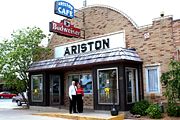
s. The Ariston Cafe
Ariston Cafe
The Ariston Cafe is a historic restaurant located in Litchfield, Illinois, USA along Old U.S. Route 66. It was added to the U.S. National Register of Historic Places in 2006.-History:...
in Litchfield is the longest-operating restaurant along former U.S. 66. and the Belevidere Cafe, Motel and Gas Station
Belevidere Cafe, Motel and Gas Station
Belevidere Cafe, Motel and Gas Station is a historic building in Litchfield, Illinois along Route 66. The site also has a residence and two motel units.-References:**-External links:*...
provided services for travelers. The route continued north past Waggoner
Waggoner, Illinois
Waggoner is a village in Montgomery County, Illinois, United States. The population was 245 at the 2000 census.-Waggoner Centennial Play:The Waggoner Centennial Players hold an annual play...
, Farmersville
Farmersville, Illinois
Farmersville is a village in Montgomery County, Illinois, United States. The population was 768 at the 2000 census.-Geography:Farmersville is located at ....
, Divernon
Divernon, Illinois
Divernon is a village in Sangamon County, Illinois, United States. The population was 1,201 at the 2000 census, and 1,131 at a 2009 estimate. It is part of the Springfield, Illinois Metropolitan Statistical Area.-Geography:...
, Glenarm
Glenarm, Illinois
Glenarm is an unincorporated community in Sangamon County, Illinois, United States. Glenarm is located along Interstate 55 south of Springfield. Glenarm has a post office with ZIP code 62536.-Education:...
and joins the other route in Springfield near the Old Capitol.
The extreme demands put on the road by World War II
World War II
World War II, or the Second World War , was a global conflict lasting from 1939 to 1945, involving most of the world's nations—including all of the great powers—eventually forming two opposing military alliances: the Allies and the Axis...
and the increased military traffic along U.S. 66 caused parts of the road to be replaced along this stretch in the 1940s. This stretch of U.S. 66 became a four lane road with two lanes in each direction; the new lanes became the southbound lanes. For 2.15 miles (3.5 km), south of Litchfield, the southbound lanes still carry two-way traffic. A new section of Route 66 headed northeast of Hamel through Livingston
Livingston, Illinois
Livingston is a village in Madison County, Illinois, United States. The population was 825 at the 2000 census.-Geography:Livingston is located at ....
. This new route bypassed Mount Olive to the northeast, later running to the west of the old route through Litchfield before joining the original route. Sections of the older alternate route were destroyed in the 1930s when Lake Springfield
Lake Springfield
Lake Springfield is a 4,260 acre reservoir located in the city of Springfield, Illinois, southeast of downtown. It is 560 feet above sea level...
was created; the fragments of the old route that remain were added to the National Register of Historic Places on May 12, 2009.
Springfield to Gardner
Gardner, Illinois
Gardner is a village in Grundy County, Illinois, United States. The population was 1,463 at the 2010 census.-Geography:Gardner is located at .-Demographics:...
, Historic 66 is now frontage road for I-55 (except for business loops for Lincoln
Lincoln, Illinois
Lincoln is a city in Logan County, Illinois, United States. It is the only town in the United States that was named for Abraham Lincoln before he became president; he practiced law there from 1847 to 1859. First settled in the 1830s, Lincoln is home to three colleges and two prisons. The three...
and Bloomington
Bloomington, Illinois
Bloomington is a city in McLean County, Illinois, United States and the county seat. It is adjacent to Normal, Illinois, and is the more populous of the two principal municipalities of the Bloomington-Normal metropolitan area...
-Normal
Normal, Illinois
Normal is an incorporated town in McLean County, Illinois, United States. It had a population of 52,497 as of the 2010 census. Normal is the smaller of two principal municipalities of the Bloomington-Normal metropolitan area...
). U.S. Route 66 continued north through Springfield past the Illinois State Fairgrounds Racetrack
Illinois State Fairgrounds Racetrack
Illinois State Fairgrounds Racetrack is a one mile long clay oval motor racetrack on the grounds of the Illinois State Fair in Springfield, the state capital. Constructed in the late 19th century and reconstructed in 1927, the "Springfield Mile" as it is known has hosted competitive auto racing...
and the Lazy A Motel. The route again joins Illinois Route 4 and continues alongside Carpenter Park
Carpenter Park
Carpenter Park is a 322-acre park on the north bank of the Sangamon River on the far north side of the city of Springfield, Illinois. The park is a listed Illinois Nature Preserve and has been designated as an Important Bird Area of Illinois...
; a small section of this route is listed on the National Register of Historic Places on May 9, 2002. U.S. 66 traversed Sherman
Sherman, Illinois
Sherman is a village in Sangamon County, Illinois, United States. The population was 2,871 at the 2000 census, and 3,873 at a 2009 estimate. It is part of the Springfield, Illinois Metropolitan Statistical Area.-Geography:Sherman is located at ....
and Broadwell
Broadwell, Illinois
Broadwell is a village in Logan County, Illinois, United States. The population was 169 at the 2000 census.-Geography:Broadwell is located at .According to the United States Census Bureau, the village has a total area of , all land....
, entering Lincoln
Lincoln, Illinois
Lincoln is a city in Logan County, Illinois, United States. It is the only town in the United States that was named for Abraham Lincoln before he became president; he practiced law there from 1847 to 1859. First settled in the 1830s, Lincoln is home to three colleges and two prisons. The three...
. From there, the route continued northeast through Lawndale
Lawndale, Illinois
Lawndale is a community in Logan County, Illinois, United States which lies northeast of Springfield. The town lies on Interstate 55, part of the old Route 66, between Atlanta and Lincoln. The town lies just south of Kickapoo Creek...
, Atlanta
Atlanta, Illinois
Atlanta is a city in Logan County, Illinois, United States. The population was 1,649 at the 2000 census, and 1,635 at a 2009 estimate.-Geography:Atlanta is located at ....
, McLean
McLean, Illinois
McLean is a village in McLean County, Illinois, United States. The population was 830 at the 2010 census. It is part of the Bloomington–Normal Metropolitan Statistical Area.-Geography:McLean is located at ....
, Funk's Grove
Funks Grove, Illinois
Funks Grove is a historic unincorporated community on U.S. Route 66 in McLean County, Illinois, United States southwest of Bloomington. The grove for which the settlement is named, Funk's Grove, is a National Natural Landmark.-Natural history:...
, and Shirley
Shirley, Illinois
Shirley is a small unincorporated municipality located in southwestern McLean County. It sits right off Interstate 55. It was founded in 1854 and currently has a population of 378. Shirley is home to the Funk Prairie Home & Rock Museum.-History:...
. In Funks Grove, Illinois
Funks Grove, Illinois
Funks Grove is a historic unincorporated community on U.S. Route 66 in McLean County, Illinois, United States southwest of Bloomington. The grove for which the settlement is named, Funk's Grove, is a National Natural Landmark.-Natural history:...
, settled by the Funk family in 1891, pure "maple sirup" is made. McLean, Illinois
McLean, Illinois
McLean is a village in McLean County, Illinois, United States. The population was 830 at the 2010 census. It is part of the Bloomington–Normal Metropolitan Statistical Area.-Geography:McLean is located at ....
is home to the famous Dixie Travel Plaza
Dixie Travel Plaza
The Dixie Travel Plaza, previously known as the Dixie Truck Stop and Dixie Trucker's Home, is a large trucker and travel plaza located in McLean, Illinois, on Interstate 55. It was established by J.P. Walters and John Geske in 1928 on old US Route 66 as a small sandwich stand in a truck mechanic's...
, a truck stop that was established as the Dixie Truckers Home in 1928. The road entered Bloomington
Bloomington, Illinois
Bloomington is a city in McLean County, Illinois, United States and the county seat. It is adjacent to Normal, Illinois, and is the more populous of the two principal municipalities of the Bloomington-Normal metropolitan area...
, passing the Central Business District
Bloomington Central Business District
The Bloomington Central Business District is a historic district in the McLean County, Illinois city of Bloomington that has been on the National Register of Historic Places since 1985. The Central Business district is roughly bordered by the downtown streets of Main, Front and Center....
and the McLean County Square
McLean County Courthouse and Square
The McLean County Courthouse and Square is located in downtown Bloomington, Illinois. The site is on the National Register of Historic Places and encompasses the old McLean County Courthouse and the courthouse-facing sides of three downtown blocks. The historic buildings at the other side of the...
. As Bloomington became Normal
Normal, Illinois
Normal is an incorporated town in McLean County, Illinois, United States. It had a population of 52,497 as of the 2010 census. Normal is the smaller of two principal municipalities of the Bloomington-Normal metropolitan area...
, the route passed Illinois State Normal University. From Normal, Route 66 continues northeast through Towanda
Towanda, Illinois
Towanda is a village in McLean County, Illinois, United States. The population was 480 at the 2010 census. It is part of the Bloomington–Normal Metropolitan Statistical Area....
, where there is a trail along the abandoned highway that highlights all eight states Route 66 travels through. There are also "Burma Shave" signs displayed along the trail.
Lexington, Illinois
Lexington is a city in McLean County, Illinois, United States. The population was 2,060 at the 2010 census. There are two theories of its name. One says it was named for the Battle of Lexington, where General Gridley's father fought...
and Chenoa
Chenoa, Illinois
Chenoa is a city in McLean County, Illinois, USA. The population was 1,785 at the 2010 census. Located at the intersections of Interstate 55, Historic Route 66, and U.S. Route 24.Founded in 1854 by Mathew T. Scott, Chenoa was created to provide a retail and trade center for his farm tenants as well...
to Pontiac
Pontiac, Illinois
Pontiac is a city in Livingston County, Illinois, United States. The population was 11,931 at the 2010 census. It is the county seat of Livingston County...
. Passing the Illinois State Police Office
Illinois State Police Office (Pontiac)
The former Illinois State Police Office in Pontiac, Illinois, United States served as the Illinois State Police District 6 headquarters from its construction in 1941 until 2003. The building, located along old U.S. Route 66, was listed on the U.S. National Register of Historic Places in...
, the route continues north through Cayuga
Cayuga, Illinois
Cayuga is an unincorporated community in Livingston County, Illinois, and is located northeast of Pontiac.-External links:*...
and Odell
Odell, Illinois
Odell is a village in Livingston County, Illinois, United States. The population was 1,014 at the 2000 census.-Media:In October 2006, Odell was featured on the USA Food Network's "Riding Old Route 66", which visited the Standard Oil station-Geography:...
to Dwight
Dwight, Illinois
Dwight is a village in located mainly in Livingston County, Illinois, with a small portion in Grundy County, Illinois. The population was 4,260 at the 2010 census. Dwight contains an original stretch of the famous U.S. Route 66, and uses a railroad station designed in 1891 by Henry Ives Cobb. It is...
. A restored Standard Oil
Standard Oil
Standard Oil was a predominant American integrated oil producing, transporting, refining, and marketing company. Established in 1870 as a corporation in Ohio, it was the largest oil refiner in the world and operated as a major company trust and was one of the world's first and largest multinational...
gas station still stands in Odell, as does a Texaco
Texaco
Texaco is the name of an American oil retail brand. Its flagship product is its fuel "Texaco with Techron". It also owns the Havoline motor oil brand....
station
Ambler's Texaco Gas Station
Ambler's Texaco Gas Station, also known as Becker's Marathon Gas Station, is a historic filling station located at the intersection of Old U.S. Route 66 and Illinois Route 17 in the village of Dwight, Illinois, United States. The station has been identified as the longest operating gas station...
in Dwight. The 18.2 miles (29.3 km) stretch of road from Cayuga to Chenoa, Illinois was added to the U.S. National Register of Historic Places
National Register of Historic Places
The National Register of Historic Places is the United States government's official list of districts, sites, buildings, structures, and objects deemed worthy of preservation...
on July 23, 2007. This section of U.S. 66 was commissioned in 1926. The road segment travels from the northeast to the southwest and begins in the southeast corner of Odell Township in Livingston County and ends in the northwest corner of Chenoa Township
Chenoa Township, McLean County, Illinois
Chenoa Township is located in McLean County, Illinois. The population was 2,305 at the 2000 census.- External links :***...
in McLean County
McLean County, Illinois
McLean County is a county in the U.S. state of Illinois. McLean County is included in the Bloomington–Normal, Illinois Metropolitan Statistical Area. According to the 2010 census, it has a population of 169,572, which is an increase of 12.7% from 150,433 in 2000. Its county seat is...
. U.S. Route 66 passes through Odell
Odell Township, Livingston County, Illinois
Odell Township is located in Livingston County, Illinois. The population was 1,208 at the 2000 census.-External links:* * *...
, Esmen
Esmen Township, Livingston County, Illinois
Esmen Township is located in Livingston County, Illinois. The population was 367 at the 2000 census.- External links :***...
, Pontiac
Pontiac Township, Livingston County, Illinois
Pontiac Township is located in Livingston County, Illinois. The population was 13,148 at the 2000 census.- External links :***...
, Eppards Point
Eppards Point Township, Livingston County, Illinois
Eppards Point Township is located in Livingston County, Illinois. The population was 472 at the 2000 census.- External links :***...
, and Pike Township
Pike Township, Livingston County, Illinois
Pike Township is located in Livingston County, Illinois. The population was 303 at the 2000 census.- External links :***...
s, on its stretch from Cayuga to Chenoa. The road is paralleled on its east by the Union Pacific Railroad
Union Pacific Railroad
The Union Pacific Railroad , headquartered in Omaha, Nebraska, is the largest railroad network in the United States. James R. Young is president, CEO and Chairman....
tracks and on its west by Interstate 55. Portions of the northbound and southbound lanes still carry traffic; in spots where one of the sections is still in use the other section is abandoned but extant.
Historic preservation
Historic preservation is an endeavor that seeks to preserve, conserve and protect buildings, objects, landscapes or other artifacts of historical significance...
eight of those are considered contributing structure
Contributing property
In the law regulating historic districts in the United States, a contributing resource or contributing property is any building, structure, or object which adds to the historical integrity or architectural qualities that make the historic district, listed locally or federally, significant...
s to the listing and six are considered non-contributing. There are also 12 highway bridges found along the segment and a box culvert
Culvert
A culvert is a device used to channel water. It may be used to allow water to pass underneath a road, railway, or embankment. Culverts can be made of many different materials; steel, polyvinyl chloride and concrete are the most common...
; six of the bridges are contributing to the National Register listing, as is the box culvert. Six of the bridges have been replaced since the historic period, and all of the bridges are constructed from concrete
Concrete
Concrete is a composite construction material, composed of cement and other cementitious materials such as fly ash and slag cement, aggregate , water and chemical admixtures.The word concrete comes from the Latin word...
. The bridges have various lengths and support structure. The box culvert along the segment of road measures 15 feet by six inches wide and was built as part of the road's foundation. This particular box culvert, like many, usually went unnoticed by travelers along the road. The section of pavement from Cayuga, south to Pontiac was part of a larger section of the roadway that began north of Cayuga in Gardner. The entire section was built in 1943 after large parts of Route 66 became badly deteriorated during the mid-1940s. The portion of the roadway that extended 27 miles (43.5 km) south of Pontiac to the newly constructed bypass at Bloomington-Normal was constructed during the early 1940s.
Gardner to Welco Corners
The route again split as it entered GardnerGardner, Illinois
Gardner is a village in Grundy County, Illinois, United States. The population was 1,463 at the 2010 census.-Geography:Gardner is located at .-Demographics:...
. These three alignments reunited at Welco Corners
Welco Corners, Illinois
Welco Corners, Illinois is a populated place in northern Will County, Illinois.It is at the junction of Interstate 55 and Joliet Road, and is within the city limits and postal delivery zone of Bolingbrook, Illinois, though it existed before the founding of Bolingbrook.- History :Welco Corners was...
, which is located in present-day Bolingbrook
Bolingbrook, Illinois
Bolingbrook is a large village in Will and DuPage Counties in the U.S. state of Illinois. As of the 2010 US Census, the population is 73,366...
.
1926 Route through Joliet
The original eastern route, most of which is the current Illinois Route 53Illinois Route 53
Illinois Route 53 is an arterial north–south state highway in northeast Illinois. Route 53 runs south from Long Grove at Illinois Route 83 to Gardner at Interstate 55 west of old U.S. Highway 66, a distance of...
, served Gardner, Braceville
Braceville, Illinois
Braceville is a village in Grundy County, Illinois, United States. The population was 793 at the 2010 census. Braceville annexed a small portion of land in Will County in 2005.-Geography:Braceville is located at ....
, Godley
Godley, Illinois
Godley is a village in Grundy and Will Counties, Illinois, United States. The population was 601 at the 2010 census.-Geography:Godley is located at ....
, and Braidwood
Braidwood, Illinois
eBraidwood is a city in Will County, Illinois, United States, approximately southwest of Chicago and south of Joliet. The population was 5,203 at the 2000 census....
before entering Wilmington
Wilmington, Illinois
Wilmington is the name of two places in the U.S. state of Illinois:*Wilmington, Greene County, Illinois*Wilmington, Will County, Illinois...
. The section of U.S. 66 from Wilmington
Wilmington, Illinois
Wilmington is the name of two places in the U.S. state of Illinois:*Wilmington, Greene County, Illinois*Wilmington, Will County, Illinois...
to Joliet
Joliet, Illinois
Joliet is a city in Will and Kendall Counties in the U.S. state of Illinois, located southwest of Chicago. It is the county seat of Will County. As of the 2010 census, the city was the fourth-most populated in Illinois, with a population of 147,433. It continues to be Illinois' fastest growing...
was added to the National Register of Historic Places on 5 May 2006, and travels through mostly agricultural land, although the area does contain the Joliet Army Ammunition Plant
Joliet Army Ammunition Plant
Joliet Army Ammunition Plant formerly known as the Joliet Arsenal was a United States Army arsenal located in Will County, Illinois, near Elwood, Illinois, south of Joliet, Illinois. Opened in 1940 during World War II, the facility consisted of the Elwood Ordnance Plant and the Kankakee Ordnance...
. This stretch of U.S. 66 spans 15.9 miles (25.6 km) through Joliet
Joliet Township, Will County, Illinois
Joliet Township is located in Will County, Illinois. The population was 86,468 at the 2000 census.- External links :****...
, Jackson
Jackson Township, Will County, Illinois
Jackson Township is located in Will County, Illinois. The population was 3,541 at the 2000 census.- External links :****...
, Wilmington
Wilmington Township, Will County, Illinois
Wilmington Township is located in Will County, Illinois, USA. The population was 6,050 at the 2000 census.- External links :****...
and Florence
Florence Township, Will County, Illinois
Florence Township is located in Will County, Illinois. The population was 642 at the 2000 census. Florence Township was formed from a portion of Wilmington Township at an unknown date.- External links :****...
Townships in Will County
Will County, Illinois
As of the census of 2000, there were 502,266 people, 167,542 households, and 131,017 families residing in the county. The population density was 600 people per square mile . There were 175,524 housing units at an average density of 210 per square mile...
. It begins in Wilmington and ends short of the Interstate 80
Interstate 80
Interstate 80 is the second-longest Interstate Highway in the United States, following Interstate 90. It is a transcontinental artery running from downtown San Francisco, California to Teaneck, New Jersey in the New York City Metropolitan Area...
interchange in Joliet, Illinois. In addition, several structures along the segment of road are included in the listing on the National Register. Contributing structures
Contributing property
In the law regulating historic districts in the United States, a contributing resource or contributing property is any building, structure, or object which adds to the historical integrity or architectural qualities that make the historic district, listed locally or federally, significant...
to the listing include one bridge, one overpass
Overpass
An overpass is a bridge, road, railway or similar structure that crosses over another road or railway...
and four concrete box culvert
Culvert
A culvert is a device used to channel water. It may be used to allow water to pass underneath a road, railway, or embankment. Culverts can be made of many different materials; steel, polyvinyl chloride and concrete are the most common...
s. The three-span, continuous steel multibeam bridge, in the northbound lanes, dates to 1950 and features concrete baluster
Baluster
A baluster is a moulded shaft, square or of lathe-turned form, one of various forms of spindle in woodwork, made of stone or wood and sometimes of metal, standing on a unifying footing, and supporting the coping of a parapet or the handrail of a staircase. Multiplied in this way, they form a...
s and top rails. The box culverts were built as part of the 1926 road's foundation and range in width from five to nine feet. There are also four non-historic bridges, constructed in the 1970s and 1980s, located along this stretch of U.S. Route 66. Modern IL 53
Illinois Route 53
Illinois Route 53 is an arterial north–south state highway in northeast Illinois. Route 53 runs south from Long Grove at Illinois Route 83 to Gardner at Interstate 55 west of old U.S. Highway 66, a distance of...
follows the route of US 66 through Joliet. North of Joliet, the road was 4 lanes wide by 1936.
It passed the Stateville Correctional Center
Stateville Correctional Center
Stateville Correctional Center is a maximum security state prison for men in Crest Hill, Illinois, USA.-History:Opened in 1925, Stateville was built to accommodate 1,506 inmates. Parts of the prison were designed according to the panopticon concept proposed by the British philosopher and prison...
in Crest Hill
Crest Hill, Illinois
Crest Hill is a city in Will County, Illinois, United States. The population was 13,329 at the 2000 census and the 2010 census population estimate was 20,867.-Geography:Crest Hill is located at...
, one of Illinois' larger prisons. After IL 53
Illinois Route 53
Illinois Route 53 is an arterial north–south state highway in northeast Illinois. Route 53 runs south from Long Grove at Illinois Route 83 to Gardner at Interstate 55 west of old U.S. Highway 66, a distance of...
splits to the north in Romeoville
Romeoville, Illinois
Romeoville is a village in Will County, Illinois, United States. The population was 21,153 at the 2000 census. As of 2006 the population has grown to 36,837. It is located in the southwest suburban area of Chicago near the newly constructed I-355 extension south from the Stevenson Expressway to I-80...
, the road is today signed only as "Historic US 66". Since the 1920s, travelers on this section of the road have stopped for fried chicken at White Fence Farm
White Fence Farm
White Fence Farm is the name of a restaurant with locations in Romeoville, Illinois and Lakewood, Colorado.The original White Fence Farm location is in Romeoville, where it has served travelers on historic US Route 66 since the 1920s. It is owned and operated by the Robert Hastert family. Manager...
. The newer alignments rejoined this original route at the community of Welco Corners, in present-day Bolingbrook, which developed at this major highway junction with a truck stop and other traveler services. When this route was bypassed by mainline US 66 in 1940, it became Alternate US Route 66.
1940 Route through Plainfield
The new western route was opened in 1940 and began in Gardner on the other (west) side of the Southern Pacific railroad tracks, taking over portions of IL 59Illinois Route 59
Illinois Route 59 is a north–south state highway in northeastern Illinois. It runs south from Illinois Route 83 in Antioch to Interstate Highway 55 in Shorewood, spanning the north–south width of Chicago's western suburbs...
and IL 126
Illinois Route 126
Illinois Route 126 is an east–west state road in northern Illinois. It runs from Illinois Route 47 in Yorkville to Interstate 55 between Plainfield and Bolingbrook. This is a distance of .- Route description :...
.
Its main purpose was to bypass Joliet. This route also served Braceville, Godley, and Braidwood, but then curved north to Channahon
Channahon, Illinois
Channahon is a village in Grundy and Will counties in the U.S. state of Illinois. The population was 12,560 at the 2010 census. Channahon is also the name of the township in which most of the village resides...
, Shorewood
Shorewood, Illinois
Shorewood is a village in Troy Township, Will County, Illinois, United States. The population was 7,686 at the 2000 census, and estimated to be 15,521 as of 2008.- Presidents :...
, and Plainfield
Plainfield, Illinois
Plainfield is a village in Will County, Illinois, United States. As of the 2007 special census, the population is 37,334.The Village includes land in Plainfield and Wheatland townships. Part of Plainfield is located in Kendall County...
, rejoining the other route at Welco Corners. After this road was opened, the original route was designated as Alternate Route 66. Today, this alignment is closed between Gardner and Braceville due to a deteriorated bridge over railroad tracks which has been demolished. The Library of Congress
Library of Congress
The Library of Congress is the research library of the United States Congress, de facto national library of the United States, and the oldest federal cultural institution in the United States. Located in three buildings in Washington, D.C., it is the largest library in the world by shelf space and...
has photos of this former magnificent arch bridge here on its web site. Beyond Braidwood, you can follow this 1940 alignment on IL 129
Illinois Route 129
Illinois Route 129 is a north–south state road in northeastern Illinois. It runs from Illinois Route 113 in downtown Braidwood north to Interstate 55. This is a distance of .- Route description :...
, I-55
Interstate 55
Interstate 55 is an Interstate Highway in the central United States. Its odd number indicates that it is a north–south Interstate Highway. I-55 goes from LaPlace, Louisiana at Interstate 10 to Chicago at U.S. Route 41 , at McCormick Place. A common nickname for the highway is "double...
, IL 59
Illinois Route 59
Illinois Route 59 is a north–south state highway in northeastern Illinois. It runs south from Illinois Route 83 in Antioch to Interstate Highway 55 in Shorewood, spanning the north–south width of Chicago's western suburbs...
, IL 126
Illinois Route 126
Illinois Route 126 is an east–west state road in northern Illinois. It runs from Illinois Route 47 in Yorkville to Interstate 55 between Plainfield and Bolingbrook. This is a distance of .- Route description :...
, and I-55 again.
1957 Freeway Route
In 1957 a new freeway, which is today's Interstate 55, was opened as US 66 from Gardner to Welco Corners, bypassing both Braidwood and Plainfield. Most portions of the 1940 western alignment which were not incorporated into the new freeway reverted to their previous state routes, except for the section from Gardner through Braidwood which became Illinois Route 129Illinois Route 129
Illinois Route 129 is a north–south state road in northeastern Illinois. It runs from Illinois Route 113 in downtown Braidwood north to Interstate 55. This is a distance of .- Route description :...
. This freeway was originally designated only as US 66, and was then also designated Interstate 55 in 1960, becoming the first complete section of I-55 in Illinois.
It served as mainline US 66 for 19 years, from 1957 to 1976, longer than either of the two previous alignments.
Between 2007 and 2008, the section of I-55 from I-80 to Welco Corners, originally built as US 66 in 1957, was rebuilt and widened to three lanes in each direction to accommodate modern traffic loads. However between Gardner and I-80, I-55 remains today mostly as it did as US 66 in 1957. This heritage is evident, with fully mature trees in interchange medians, several 1957-era motels and gas stations still operating today, and several original bridges still in use, such as the Smith Bridge over the Des Plaines River
Des Plaines River
The Des Plaines River is a river that flows southward for through southern Wisconsin and northern Illinois in the U.S. Midwest, eventually meeting the Kankakee River west of Channahon to form the Illinois River, a tributary of the Mississippi River....
, and the Arsenal Road overpass at Exit 245.
Welco Corners to Chicago
From Welco Corners in Bolingbrook to Indian Head ParkIndian Head Park, Illinois
Indian Head Park is a village in Cook County, Illinois slightly north of the intersection of Interstate 294 and Interstate 55. The village is south of Western Springs, north of Burr Ridge, and west of Countryside. The population was 3,685 at the 2000 census...
, I-55 is on top of old US 66. Here, it passed through Woodridge
Woodridge, Illinois
Woodridge is a suburb of Chicago, located primarily in DuPage County, Illinois with portions in Will County and Cook County. It uses the 630 and 331 area codes. The population was 30,934 at the 2000 census. A special census commissioned in 2003 put the population at 33,253...
, Darien
Darien, Illinois
Darien is a city in DuPage County, Illinois, USA. The population was 22,086 at the 2010 census.A suburb of Chicago, Darien was named after a town in Connecticut.-Popular culture:...
, Willowbrook
Willowbrook, DuPage County, Illinois
Willowbrook is a village in DuPage County, Illinois, United States. The population was 8,967 at the 2000 census.-History:Willowbrook grew from the Ridgemoor subdivision...
, and Burr Ridge
Burr Ridge, Illinois
Burr Ridge is a suburb of Chicago, in Cook and DuPage Counties, Illinois. The population was 11,560 at the 2008 census.-Geography:Burr Ridge is located at ....
. This section of mainline I-55 is signed as "Historic US 66", though a section of the original highway which serves as the north-side service road veers away from I-55 in Darien and retains the old Route 66 feel. Dell Rhea's Chicken Basket
Dell Rhea's Chicken Basket
Dell Rhea's Chicken Basket is a restaurant in Willowbrook, DuPage County, Illinois. It is located along historical U.S. Route 66, near present-day Interstate 55.-History:...
in Willowbrook is still a popular stop for motorists before reaching Chicago
Chicago
Chicago is the largest city in the US state of Illinois. With nearly 2.7 million residents, it is the most populous city in the Midwestern United States and the third most populous in the US, after New York City and Los Angeles...
. From Indian Head Park, I-55 separates to follow a more southerly route as the Stevenson Expressway
Stevenson Expressway
The Stevenson Expressway is the major Interstate highway leading southwest out of the city of Chicago in Illinois. It is signed as Interstate 55 for the entire length....
, while Old US 66 continued as present-day Joliet Road, traversing Countryside
Countryside, Illinois
Countryside is a city in Cook County, Illinois, United States. The population was 5,991 at the 2000 census.-Geography:Countryside is located at ....
and McCook
McCook, Illinois
McCook is a suburb of Chicago in Cook County, in the U.S. state of Illinois. As of the 2000 census, the village population was 254, which is the lowest population of all municipalities in the county. It was named for John J. McCook, a late 19th century director of the Santa Fe Railroad and a former...
, where it intersected the US 12 / US 20 / US 45 multiplex at LaGrange Road. A brief stretch of Route 66 in McCook has been permanently damaged by local quarries and is closed. A well-marked detour returns you to Joliet Road. The route jogged north briefly on Harlem Avenue in Berwyn
Berwyn, Illinois
Berwyn is a city in Cook County, Illinois, co-existent with Berwyn Township, which was formed in 1908 after breaking off from Cicero Township. As of the 2000 census, the city had a total population of 54,016.-Demographics:...
where it met US Route 34 at Ogden Avenue
Ogden Avenue (Chicago)
Ogden Avenue is an arterial street extending from the Near West Side of Chicago to Aurora, Illinois.The street follows the route of the Southwestern Plank Road, which opened in 1848 across swampy terrain between Chicago and Riverside, Illinois, and was extended to Naperville by 1851.The 1909 Plan...
. From Berwyn it continued northeastward on Ogden Avenue passing through Lyons
Lyons, Illinois
Lyons is a village in Cook County, Illinois, United States. The population was 10,255 at the 2000 census.-History:Incorporated in 1888, Lyons is steeped in earlier historical roots. In 1673 French Explorer Louis Joliet and Jesuit missionary Father Pierre Marquette left Green Bay, Wisconsin by canoe...
and Cicero
Cicero, Illinois
Cicero is an incorporated town in Cook County, Illinois, United States. The population was 83,891 at the 2010 census. Cicero is named for the town of Cicero, New York, which in turn was named for Marcus Tullius Cicero, the Roman statesman and orator....
before entering Chicago. Turning due east from Ogden Avenue, US 66 entered the Chicago Loop
Chicago Loop
The Loop or Chicago Loop is one of 77 officially designated Chicago community areas located in the City of Chicago, Illinois. It is the historic commercial center of downtown Chicago...
via Jackson Boulevard, and after 1955 as the pair of one-way streets, Jackson Boulevard (eastbound) and Adams Street (westbound). Route 66 always ended at US Route 41. Originally it ended at Michigan Avenue
Michigan Avenue (Chicago)
Michigan Avenue is a major north-south street in Chicago which runs at 100 east south of the Chicago River and at 132 East north of the river from 12628 south to 950 north in the Chicago street address system...
which was U.S. Route 41 and a changing list of other US routes at the time, but when Lake Shore Drive
Lake Shore Drive
Lake Shore Drive is a mostly freeway-standard expressway running parallel with and alongside the shoreline of Lake Michigan through Chicago, Illinois, USA. Except for the portion north of Foster Avenue , Lake Shore Drive is designated as part of U.S...
was designated as US 41 in 1938, US 66 was extended two blocks farther east on Jackson Drive through Grant Park
Grant Park (Chicago)
Grant Park, with between the downtown Chicago Loop and Lake Michigan, offers many different attractions in its large open space. The park is generally flat. It is also crossed by large boulevards and even a bed of sunken railroad tracks...
to end there, at the shore of Lake Michigan
Lake Michigan
Lake Michigan is one of the five Great Lakes of North America and the only one located entirely within the United States. It is the second largest of the Great Lakes by volume and the third largest by surface area, after Lake Superior and Lake Huron...
. This last two-block section of Jackson is two-way, so when Jackson and Adams were made a pair of one-way streets in 1955, westbound US 66 made a 1-block long jog northbound on Michigan Avenue before continuing west on Adams. The current "End Historic US 66" markers are located on Jackson (eastbound) and Adams (westbound) at Michigan Avenue, in the Chicago Landmark
Chicago Landmark
Chicago Landmark is a designation of the Mayor of Chicago and the Chicago City Council for historic buildings and other sites in Chicago, Illinois, United States. Listed sites are selected after meeting a combination of criteria, including historical, economic, architectural, artistic, cultural,...
Historic Michigan Boulevard District
Historic Michigan Boulevard District
The Historic Michigan Boulevard District is a historic district in the Loop community area of Chicago in Cook County, Illinois, United States encompassing Michigan Avenue between 11th or Roosevelt Road , depending on the source, and Randolph Streets and named after the nearby Great Lake...
, in recognition of this earlier terminus point at Michigan Avenue.
Filling stations
Gasoline
Gasoline , or petrol , is a toxic, translucent, petroleum-derived liquid that is primarily used as a fuel in internal combustion engines. It consists mostly of organic compounds obtained by the fractional distillation of petroleum, enhanced with a variety of additives. Some gasolines also contain...
distribution simpler. The earliest gas stations were curbside but these were quickly rendered obsolete because of their tendency to back up traffic when a customer used the roadside pumps. The curbside filling station was the first type of business to use the actual term "filling station
Filling station
A filling station, also known as a fueling station, garage, gasbar , gas station , petrol bunk , petrol pump , petrol garage, petrol kiosk , petrol station "'servo"' in Australia or service station, is a facility which sells fuel and lubricants...
." Other types of gas stations evolved such as the house or cottage type, the house and canopy, the house and bays, and the oblong box type. Examples of extant filling stations along Route 66 in Illinois can be found in varying states of disrepair, and a few have been fully restored.
Restaurants
Howard Deering Johnson
Howard Deering Johnson was an entrepreneur, businessman, and the founder of an American chain of restaurants and motels under one company of the same name, Howard Johnson's.-Early life:...
, who provided predictable, simple dishes. The first roadside cafe
Café
A café , also spelled cafe, in most countries refers to an establishment which focuses on serving coffee, like an American coffeehouse. In the United States, it may refer to an informal restaurant, offering a range of hot meals and made-to-order sandwiches...
s were part of motor camp complexes but others, such as Johnson's started explicitly as cafes and evolved further from there. Large companies, such as Johnson's, or the Steak 'n Shake chain which began in Normal, Illinois
Normal, Illinois
Normal is an incorporated town in McLean County, Illinois, United States. It had a population of 52,497 as of the 2010 census. Normal is the smaller of two principal municipalities of the Bloomington-Normal metropolitan area...
and was based on the pioneering idea of curbside service at your car, enjoyed success alongside what were mostly "mom and pop" eateries dotting the Mother Road.
Corn dog
A corn dog is a hot dog sausage coated in a thick layer of cornmeal batter and deep fried in oil, although some are baked. Almost all corn dogs are served on wooden sticks, though some early versions had no stick.-History:...
was invented in the city under the name "Cozy Dog," although there is some debate to the actual origin of the popular snack. The Cozy Dog Drive In
Cozy Dog Drive In
The Cozy Dog Drive In is a restaurant located in Springfield, Illinois which claims to be the first place to serve the corn dog. The claim states that the deep fried, battered hot dog on a stick was invented by Ed Waldmire Jr. and his friend, Don Strand while they were stationed at an Amarillo,...
has been a Springfield Route 66 staple since 1950. One of the first U.S. drive-thru window is still in operation in Springfield, along Route 66, at the Maid-Rite Sandwich Shop . The longest-running restaurant along the entire stretch of U.S. Route 66, nationwide, is the Ariston Cafe
Ariston Cafe
The Ariston Cafe is a historic restaurant located in Litchfield, Illinois, USA along Old U.S. Route 66. It was added to the U.S. National Register of Historic Places in 2006.-History:...
in Litchfield. The Ariston is an excellent example of the type of mom and pop operation that flourished along 66 in Illinois.
Camps, motor courts, and motels
Motorists along Route 66 during the 1920s carried the essentials with them, and often simply set up camp on a rural roadside. Eventually tourist camps began to spring up along the highway. At first the campsites and cabins, offered for $.25 and $.50, were unfurnished and the tourist camps offered few amenities. As amentities, such as communal toilets began to appear, travelers began to demand them.Bridges
Nearly all bridgeBridge
A bridge is a structure built to span physical obstacles such as a body of water, valley, or road, for the purpose of providing passage over the obstacle...
s along Old Route 66 in Illinois are constructed from concrete
Concrete
Concrete is a composite construction material, composed of cement and other cementitious materials such as fly ash and slag cement, aggregate , water and chemical admixtures.The word concrete comes from the Latin word...
, this is the case with very few exceptions. They are simple, lack ornamentation and all of their major components, abutments, piers, floor beams, decks, stringers, and railings were constructed from concrete. The only ornamentation is found in the railings, which sometimes contained baluster
Baluster
A baluster is a moulded shaft, square or of lathe-turned form, one of various forms of spindle in woodwork, made of stone or wood and sometimes of metal, standing on a unifying footing, and supporting the coping of a parapet or the handrail of a staircase. Multiplied in this way, they form a...
s. Between 1926–1940 most of the Route 66 bridges in Illinois were built as two lane bridges. Later incarnations of bridges, built after 1940 were paired with two lanes going in each direction.
Significance
U.S. Route 66 has come to stand for the collective, American tourist experience and holds a special place in American popular culture. There is a certain nostalgic appeal to Route 66 that is associated with the thrill of the open road which has contributed to its popularity. Looking at the historic roadway through Illinois from a different perspective it reveals a unique history which tells the story of movement across the prairiePrairie
Prairies are considered part of the temperate grasslands, savannas, and shrublands biome by ecologists, based on similar temperate climates, moderate rainfall, and grasses, herbs, and shrubs, rather than trees, as the dominant vegetation type...
and road building across the same terrain. Study of the highway in Illinois also reveals the evolution of the interstate highway system and the growing popularity of automobiles.
Aside from the six sections of the route in Illinois that have been listed on the U.S. National Register of Historic Places the entire stretch of 66 through Illinois has been declared a National Scenic Byway
National Scenic Byway
A National Scenic Byway is a road recognized by the United States Department of Transportation for its archeological, cultural, historic, natural, recreational, and/or scenic qualities. The program was established by Congress in 1991 to preserve and protect the nation's scenic but often...
. The 436 miles (701.7 km) stretch of road was declared a scenic byway on September 22, 2005 by the U.S. Department of Transportation.
External links
- Illinois Route 66 (America's Byways)
- Illinois Digital Archives: State Highway Maps