
Litchfield, Illinois
Encyclopedia
Litchfield is a city in Montgomery County, Illinois
, United States
. The population was 6,815 at the 2000 census, and 6,588 in 2009. It is located in south central Illinois
, south of Springfield
and on the northern edge of the Greater St. Louis
Metro-East area.
is one of the oldest restaurants along the historic U.S. Route 66
, commonly known as Old Route 66, though the cafe itself claims it could possibly be the oldest http://www.ariston-cafe.com/history.html. The Ariston Café was founded in 1924 in the town of Carlinville, Illinois, but was later moved to its present location. The cafe was inducted into the Route 66 Hall of Fame in 1992. Another landmark is Litchfield's Lake Lou Yaeger
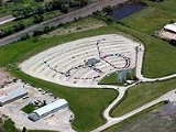
, located northeast of town.http://www.litchfield.il.us/Tourism/Attractions.htm. The SkyView Theater is a member of the Route 66 Hall of Fame and has been in operation since 1951.http://www.legendsofamerica.com/IL-Litchfield.html.
According to the United States Census Bureau
, the city has a total area of 5.1 square miles (13.2 km²), all of it land.
of 2000, there were 6,815 people, 2,772 households, and 1,785 families residing in the city. The population density
was 1,338.5 people per square mile (517.0/km²). There were 3,011 housing units at an average density of 591.4 per square mile (228.4/km²). The racial makeup of the city was 98.31% White, 0.37% African American, 0.18% Native American, 0.26% Asian, 0.01% Pacific Islander, 0.22% from other races
, and 0.65% from two or more races. Hispanic or Latino of any race were 0.95% of the population.
There were 2,772 households out of which 31.3% had children under the age of 18 living with them, 48.7% were married couples
living together, 11.9% had a female householder with no husband present, and 35.6% were non-families. 32.5% of all households were made up of individuals and 17.0% had someone living alone who was 65 years of age or older. The average household size was 2.37 and the average family size was 2.97.
 In the city the population was spread out with 25.6% under the age of 18, 7.5% from 18 to 24, 26.6% from 25 to 44, 20.0% from 45 to 64, and 20.3% who were 65 years of age or older. The median age was 38 years. For every 100 females there were 86.1 males. For every 100 females age 18 and over, there were 80.3 males.
The median income for a household in the city was $28,717, and the median income for a family was $34,139. Males had a median income of $26,238 versus $19,545 for females. The per capita income
for the city was $14,612. About 15.7% of families and 16.6% of the population were below the poverty line, including 22.9% of those under age 18 and 11.2% of those age 65 or over.
Litchfield also has the highest number of restaurants per capita in the United States.
is located two nautical miles (3.7 km) southwest of the central business district
of Litchfield.
Illinois
Illinois is the fifth-most populous state of the United States of America, and is often noted for being a microcosm of the entire country. With Chicago in the northeast, small industrial cities and great agricultural productivity in central and northern Illinois, and natural resources like coal,...
, United States
United States
The United States of America is a federal constitutional republic comprising fifty states and a federal district...
. The population was 6,815 at the 2000 census, and 6,588 in 2009. It is located in south central Illinois
Illinois
Illinois is the fifth-most populous state of the United States of America, and is often noted for being a microcosm of the entire country. With Chicago in the northeast, small industrial cities and great agricultural productivity in central and northern Illinois, and natural resources like coal,...
, south of Springfield
Springfield, Illinois
Springfield is the third and current capital of the US state of Illinois and the county seat of Sangamon County with a population of 117,400 , making it the sixth most populated city in the state and the second most populated Illinois city outside of the Chicago Metropolitan Area...
and on the northern edge of the Greater St. Louis
St. Louis, Missouri
St. Louis is an independent city on the eastern border of Missouri, United States. With a population of 319,294, it was the 58th-largest U.S. city at the 2010 U.S. Census. The Greater St...
Metro-East area.
Attractions
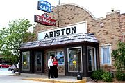
The Ariston CafeAriston Cafe
The Ariston Cafe is a historic restaurant located in Litchfield, Illinois, USA along Old U.S. Route 66. It was added to the U.S. National Register of Historic Places in 2006.-History:...
is one of the oldest restaurants along the historic U.S. Route 66
U.S. Route 66
U.S. Route 66 was a highway within the U.S. Highway System. One of the original U.S. highways, Route 66 was established on November 11, 1926 -- with road signs erected the following year...
, commonly known as Old Route 66, though the cafe itself claims it could possibly be the oldest http://www.ariston-cafe.com/history.html. The Ariston Café was founded in 1924 in the town of Carlinville, Illinois, but was later moved to its present location. The cafe was inducted into the Route 66 Hall of Fame in 1992. Another landmark is Litchfield's Lake Lou Yaeger
Lake Lou Yaeger
Lake Lou Yaeger is a 1,300-acre reservoir located in Montgomery County, Illinois. Created by damming the West Fork of Illinois's Shoal Creek, it was built for recreation, sport fishing, and flood control purposes. The lake is 8 miles long and 0.5 miles wide...
, located northeast of town.http://www.litchfield.il.us/Tourism/Attractions.htm. The SkyView Theater is a member of the Route 66 Hall of Fame and has been in operation since 1951.http://www.legendsofamerica.com/IL-Litchfield.html.
Geography
Litchfield is located at 39°10′36"N 89°39′13"W (39.176741, -89.653721).According to the United States Census Bureau
United States Census Bureau
The United States Census Bureau is the government agency that is responsible for the United States Census. It also gathers other national demographic and economic data...
, the city has a total area of 5.1 square miles (13.2 km²), all of it land.
Demographics
As of the censusCensus
A census is the procedure of systematically acquiring and recording information about the members of a given population. It is a regularly occurring and official count of a particular population. The term is used mostly in connection with national population and housing censuses; other common...
of 2000, there were 6,815 people, 2,772 households, and 1,785 families residing in the city. The population density
Population density
Population density is a measurement of population per unit area or unit volume. It is frequently applied to living organisms, and particularly to humans...
was 1,338.5 people per square mile (517.0/km²). There were 3,011 housing units at an average density of 591.4 per square mile (228.4/km²). The racial makeup of the city was 98.31% White, 0.37% African American, 0.18% Native American, 0.26% Asian, 0.01% Pacific Islander, 0.22% from other races
Race (United States Census)
Race and ethnicity in the United States Census, as defined by the Federal Office of Management and Budget and the United States Census Bureau, are self-identification data items in which residents choose the race or races with which they most closely identify, and indicate whether or not they are...
, and 0.65% from two or more races. Hispanic or Latino of any race were 0.95% of the population.
There were 2,772 households out of which 31.3% had children under the age of 18 living with them, 48.7% were married couples
Marriage
Marriage is a social union or legal contract between people that creates kinship. It is an institution in which interpersonal relationships, usually intimate and sexual, are acknowledged in a variety of ways, depending on the culture or subculture in which it is found...
living together, 11.9% had a female householder with no husband present, and 35.6% were non-families. 32.5% of all households were made up of individuals and 17.0% had someone living alone who was 65 years of age or older. The average household size was 2.37 and the average family size was 2.97.
The median income for a household in the city was $28,717, and the median income for a family was $34,139. Males had a median income of $26,238 versus $19,545 for females. The per capita income
Per capita income
Per capita income or income per person is a measure of mean income within an economic aggregate, such as a country or city. It is calculated by taking a measure of all sources of income in the aggregate and dividing it by the total population...
for the city was $14,612. About 15.7% of families and 16.6% of the population were below the poverty line, including 22.9% of those under age 18 and 11.2% of those age 65 or over.
Litchfield also has the highest number of restaurants per capita in the United States.
Transportation
Litchfield Municipal AirportLitchfield Municipal Airport (Illinois)
Litchfield Municipal Airport is a public use airport located two nautical miles southwest of the central business district of Litchfield, in Montgomery County, Illinois, United States. It is owned by the Litchfield Airport Authority....
is located two nautical miles (3.7 km) southwest of the central business district
Central business district
A central business district is the commercial and often geographic heart of a city. In North America this part of a city is commonly referred to as "downtown" or "city center"...
of Litchfield.
External links
- Ariston Cafe
- The SkyView theater
- Litchfield Illinois, Historical Society of Montgomery County Illinois