
Odell, Illinois
Encyclopedia

Livingston County, Illinois
Livingston County is a county located in the U.S. state of Illinois. According to the 2010 census, it has a population of 38,950, which is a decrease of 1.8% from 39,678 in 2000. Its county seat is Pontiac....
, Illinois
Illinois
Illinois is the fifth-most populous state of the United States of America, and is often noted for being a microcosm of the entire country. With Chicago in the northeast, small industrial cities and great agricultural productivity in central and northern Illinois, and natural resources like coal,...
, United States
United States
The United States of America is a federal constitutional republic comprising fifty states and a federal district...
. The population was 1,014 at the 2000 census.
Media
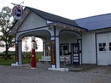
In October 2006, Odell was featured on the USA Food Network's "Riding Old Route 66", which visited the Standard Oil stationGeography
Odell is located at 41.003624°N 88.522135°W.According to the United States Census Bureau
United States Census Bureau
The United States Census Bureau is the government agency that is responsible for the United States Census. It also gathers other national demographic and economic data...
, the village has a total area of 1.1 square miles (2.8 km²), of which, 1.1 square miles (2.8 km²) of it is land and 0.88% is water.
Founding
Dwight was laid out by Sydney S. Morgan (25 January 1823 - 5 April 1884) and Henry A. Gardner (2 April 1816 – 27 July 1875) on 10 August 1856. Both men were railroad engineers who had worked on the survey and construction of what soon became the Chicago and Alton Railroad. For a time Sydney S. Morgan divided his time between Joliet and Odell, but soon settled in Odell on a permanent basis where he became the town’s chief promoter. Gardner was born in Berkshire County, MassachusettsMassachusetts
The Commonwealth of Massachusetts is a state in the New England region of the northeastern United States of America. It is bordered by Rhode Island and Connecticut to the south, New York to the west, and Vermont and New Hampshire to the north; at its east lies the Atlantic Ocean. As of the 2010...
and had begun his railroad career working as a rodman on an extension of the Great Western Railroad in Massachusetts. He rose quickly through the ranks until he became chief engineer of the Mohawk and Hudson Railroad. Gardner came west in 1853 to work assistant engineer to Oliver H. Lee on the Chicago and Mississippi Railroad, He purchased land near Dwight
Dwight, Illinois
Dwight is a village in located mainly in Livingston County, Illinois, with a small portion in Grundy County, Illinois. The population was 4,260 at the 2010 census. Dwight contains an original stretch of the famous U.S. Route 66, and uses a railroad station designed in 1891 by Henry Ives Cobb. It is...
and later went on to become Chief Engineer on the Michigan Central Railroad
Michigan Central Railroad
The Michigan Central Railroad was originally incorporated in 1846 to establish rail service between Detroit, Michigan and St. Joseph, Michigan. The railroad later operated in the states of Michigan, Indiana, and Illinois in the United States, and the province of Ontario in Canada...
. Gardner was never a resident of Odell. The town was platted when it became clear that the railroad would pass through their land. This Railroad was originally known as the Chicago and Mississippi Railroad, but quickly became The Chicago Alton and St. Louis, and then the Chicago and Alton. An excursion train ran through the town on 4 July 1854 regular service began in August 1854. Before the coming of the railroad, the land which became Odell Township was completely unsettled. Between 1852 and 1855 almost all of the land in the township was entered and farms were rapidly developed. The land on which the town would soon be erected had been first purchased from the government by. James C. Spencer and Henry A. Gardner on 4 May 1853. Through a series of quick transactions, Spencer sold his land to William H. Odell who then transferred it to Sydney S. Morgan.
Original design
The town was surveyed by Thomas F. Norton, deputy surveyor of Livingston County. The railroad had been granted a 100 feet (30.5 m) swath of land extending diagonally through the town. This presented a problem in town design, which was solved at Odell by aligning the entire Original Town with the tracks. A similar problem was presented by several towns along this railroad. Unlike the Toledo Peoria and Western Railroad, built through Livingston County at about the same time, a standard plan with shared street names does not seem to have been used along the Chicago and Mississippi. Lots sold from twenty to thirty dollars, with twenty being more common. Where the tracks passed through the town, the land used by the railroad was widened an additional 100 yards on both sides of the tracks, to create railroad grounds, although at Odell they were not labeled as such. This kind of widening of railroad property at townsites was a common feature of railroad towns built in the 1850s and may be seen at places like DwightDwight, Illinois
Dwight is a village in located mainly in Livingston County, Illinois, with a small portion in Grundy County, Illinois. The population was 4,260 at the 2010 census. Dwight contains an original stretch of the famous U.S. Route 66, and uses a railroad station designed in 1891 by Henry Ives Cobb. It is...
, Towanda
Towanda, Illinois
Towanda is a village in McLean County, Illinois, United States. The population was 480 at the 2010 census. It is part of the Bloomington–Normal Metropolitan Statistical Area....
, McLean
McLean, Illinois
McLean is a village in McLean County, Illinois, United States. The population was 830 at the 2010 census. It is part of the Bloomington–Normal Metropolitan Statistical Area.-Geography:McLean is located at ....
, Fairbury
Fairbury, Illinois
Fairbury is a city in Livingston County, Illinois, United States. The population was 3,968 at the 2000 census.-We Hear You America:In November 2010, the fundraising committee for Dominy Memorial Library began encouraging Fairbury citizens to visit the Reader's Digest web site and "Cheer" for the...
and Chatsworth
Chatsworth, Illinois
Chatsworth is an incorporated town in Livingston County, Illinois, United States. The population was 1,265 at the 2000 census.-Geography:Chatsworth is located at ....
; it became less common with later railroad towns. The depot at Odell was on the north side of the tracks and the two early elevators on the south side. The Original Town included twenty-four numbered blocks, each of which contained up to twenty lots. There was no central public square designated on the plat. The original town plan remains substantially unaltered to this day.
Early growth
The first sign of activity at the site of the new town was the building of a switch and tank at the townsite. For the first year the only inhabitants of the place were railroad employees who manned the station and kept water in the tank. Daniel Smith, of New YorkNew York
New York is a state in the Northeastern region of the United States. It is the nation's third most populous state. New York is bordered by New Jersey and Pennsylvania to the south, and by Connecticut, Massachusetts and Vermont to the east...
, was the first station master. Slowly a few local merchants were attracted to the townsite; some came from the now defunct town of New Michigan in northern Livingston County. David Williams put up a shack and began to sell “a few basketfuls of groceries and notions” He soon gave up and returned to New Michigan. The railroad erected a small warehouse which was rented out for use as a grocery store. The first dwelling in Odell was erected by Sydney S. Morgan for the use of Thomas Lyon. Morgan also began buying grain from local farmers. In the fall of 1857 A.A. Streator built a small hotel. In the same year a grain elevator and a school was erected. By the spring of 1858 Odell had about 100 people. On 8 February 1867 the Town of Odell was officially organized.
Becoming a highway town
Early Odell was a railroad town and a grain collection point. It was surrounded by some of the richest agricultural land in the United States. By the late 1870s over a million and a half bushels of grain were being shipped from Odell. In 1877 a newspaper, the Odell Herald was established. In May 0f 1886 several buildings in Odell were destroyed by a powerful Tornado. By the year 1900 there were 1,000 people in the town and since that date its population has remained at about that number. The major change came not in population, but in transportation as Odell made the transition from a railroad to a highway town. In 1921 the state put under contract a highway paving project for what at first was known as the Chicago-Springfield East St. Louis Road. Paving was finished through Odell in 1922. The designation of the road was soon changed to Route 4. In 1926, what was substantially the same road, became Route 66U.S. Route 66
U.S. Route 66 was a highway within the U.S. Highway System. One of the original U.S. highways, Route 66 was established on November 11, 1926 -- with road signs erected the following year...
. At first all of these roads passed through the center of Odell and by 1933 the local citizens became so frustrated by the inability of people to cross the road that they constructed a pedestrian underpass beneath the highway. In 1946 the problem was eased when a bypass was built around the town. In 1932 Patrick O’Donnell built the Standard Oil and Gasoline Station to serve traffic along the highway; this building has now been carefully restored and has become a popular stop for visitors touring Route 66. The station was added to the National Register of Historic Places
National Register of Historic Places
The National Register of Historic Places is the United States government's official list of districts, sites, buildings, structures, and objects deemed worthy of preservation...
in 1997. In 1964 the first stage of Interstate 55 was completed past Odell. It was improved in the 1970s. This highway substantially paralleled both the earlier roads and the original route of the Chicago and Mississippi Railroad.
Demographics
As of the censusCensus
A census is the procedure of systematically acquiring and recording information about the members of a given population. It is a regularly occurring and official count of a particular population. The term is used mostly in connection with national population and housing censuses; other common...
of 2000, there were 1,014 people, 408 households, and 283 families residing in the village. The population density
Population density
Population density is a measurement of population per unit area or unit volume. It is frequently applied to living organisms, and particularly to humans...
was 909.0 people per square mile (349.6/km²). There were 433 housing units at an average density of 388.2 per square mile (149.3/km²). The racial makeup of the village was 97.93% White, 0.10% African American, 0.10% Native American, 0.30% Asian, 0.69% from other races
Race (United States Census)
Race and ethnicity in the United States Census, as defined by the Federal Office of Management and Budget and the United States Census Bureau, are self-identification data items in which residents choose the race or races with which they most closely identify, and indicate whether or not they are...
, and 0.89% from two or more races. Hispanic or Latino of any race were 1.48% of the population.
There were 408 households out of which 34.3% had children under the age of 18 living with them, 54.4% were married couples
Marriage
Marriage is a social union or legal contract between people that creates kinship. It is an institution in which interpersonal relationships, usually intimate and sexual, are acknowledged in a variety of ways, depending on the culture or subculture in which it is found...
living together, 11.5% had a female householder with no husband present, and 30.4% were non-families. 28.2% of all households were made up of individuals and 10.3% had someone living alone who was 65 years of age or older. The average household size was 2.49 and the average family size was 3.04.
In the village the population was spread out with 29.8% under the age of 18, 5.0% from 18 to 24, 28.1% from 25 to 44, 23.4% from 45 to 64, and 13.7% who were 65 years of age or older. The median age was 37 years. For every 100 females there were 93.1 males. For every 100 females age 18 and over, there were 95.1 males.
The median income for a household in the village was $41,346, and the median income for a family was $51,250. Males had a median income of $37,614 versus $25,536 for females. The per capita income
Per capita income
Per capita income or income per person is a measure of mean income within an economic aggregate, such as a country or city. It is calculated by taking a measure of all sources of income in the aggregate and dividing it by the total population...
for the village was $18,538. About 7.7% of families and 8.9% of the population were below the poverty line, including 11.8% of those under age 18 and 9.9% of those age 65 or over.