

Macoupin County, Illinois
Encyclopedia
Macoupin County is a county
located in the southwestern portion of the U.S. state
of Illinois
. According to the 2010 census, it has a population of 47,765, which is a decrease of 2.6% from 49,019 in 2000. The county seat
is Carlinville
. Macoupin County is an outlying county of the Metro-East
region of the Greater St. Louis metropolitan area.
The primary industry is agriculture
, consisting of crops of corn
(maize), soybean
s, and some wheat
.
when the first white settlers arrived. Indeed, macoupin is the Miami-Illinois term for the American lotus, Nelumbo lutea. None of the native Indians remain, although some descendants of the earliest European settlers claim partial ancestry. The first European contact was by French
explorers in the seventeenth century, travelling southward down the major rivers. The main European settlement was from the southwest, as people moved inland from the established transportation route of the Mississippi River
.
Macoupin County was established on January 17, 1829. It was formed out of Greene and Madison Counties and was named after Macoupin Creek
, which runs near Carlinville and meanders southwest to the Illinois River
. The economy
was based on subsistence agriculture
, and communication was to the southwest.
In the middle 19th century, Illinois developed and changed rapidly. The greatest change was in the building of railroads
, and Macoupin County was on the rail and road transportation link between St. Louis and the still-young metropolis of Chicago
. The county lies midway between St. Louis and the relocated state capital of Springfield
. The economy was still based entirely on agriculture
, but there was now easier access to markets. Towns were small, sparsely distributed, and any new communities were founded along the railroad lines that provided transportation. Culturally, the county remained closer to its historical ties with St. Louis than to more northerly areas within the state.
Agriculture remained a mainstay of the economy, but this was joined by coal mining
, an industry that partially changed the complexion of the county. With coal underlying the entire region, the most economical development was to place mines alongside the railroad tracks (for transportation of coal), and located in or near already-existing towns. By the twentieth century, there were mines in many towns, all of them with substantial populations of foreign-born miners from everywhere in Europe
.
During the twentieth century, agriculture and coal mining remained the mainstays of the county's economy, and the county's fortunes rose and fell with them. Farming was still family based
. Macoupin County was often at the center of major labor disputes between mine owners and miners, and was a hotbed
of union
activity. The county had previously played a major role in violent 1890's disputes that brought unwanted national attention, was at center stage when the United Mine Workers
rose to power, and was again prominent during the internecine war between the UMW and the Progressive Mine Workers
of the 1930s.
Agriculture remained as the county's prime economic activity, but farming became a large-scale corporate
enterprise, with small family farms rapidly disappearing. Coal mining decreased, and has almost disappeared entirely. Buildings and structures related to coal mining were torn down as they wasted away, so that there is now little to see of this once-major industry.
Towns were (and still are) characterized either by a midwestern town square
layout, or by a main street
layout. In the former, a central city block may be a small park
with a gazebo
, and with the small business
es of the town surrounding it. In the latter, a single street will have the small businesses of the town lining either side of it. Carlinville has a city square layout, with the main county building occupying the central city block. This building houses all the offices of the county. Typically, churches of the various denomination
s will lie within two or three blocks of the town square, or sometimes will lie mainly along a single street near the town's center.
With modern roads easily accessible, some towns in the northern part of the county became virtual bedroom communities
as people commuted to Springfield to work and shop, hastening the decline of small businesses in the towns. The same effect was felt in the southernmost part of the county, and in 2005, the U.S. Census Bureau
included the county in the St. Louis Metropolitan Statistical Area
due to increased commuting patterns and employment in St. Louis and the Metro-East
.
of 2000, there were 49,019 people, 19,253 households, and 13,631 families residing in the county. The population density
was 57 people per square mile (22/km²). There were 21,097 housing units at an average density of 24 per square mile (9/km²). The racial makeup of the county was 97.99% White
, 0.82% Black
or African American
, 0.22% Native American
, 0.18% Asian
, 0.03% Pacific Islander
, 0.15% from other races
, and 0.61% from two or more races. 0.62% of the population were Hispanic
or Latino
of any race. 32.9% were of German, 12.8% American
, 12.0% English
, 10.5% Irish
and 8.6% Italian
ancestry according to Census 2000.
There were 19,253 households out of which 31.40% had children under the age of 18 living with them, 58.10% were married couples
living together, 8.90% had a female householder with no husband present, and 29.20% were non-families. 25.60% of all households were made up of individuals and 13.70% had someone living alone who was 65 years of age or older. The average household size was 2.48 and the average family size was 2.97.
In the county the population was spread out with 24.60% under the age of 18, 8.30% from 18 to 24, 26.70% from 25 to 44, 22.90% from 45 to 64, and 17.50% who were 65 years of age or older. The median age was 39 years. For every 100 females there were 94.90 males. For every 100 females age 18 and over, there were 90.90 males.
The median income for a household in the county was $36,190, and the median income for a family was $43,021. Males had a median income of $34,369 versus $22,293 for females. The per capita income
for the county was $17,298. About 7.10% of families and 9.40% of the population were below the poverty line, including 12.50% of those under age 18 and 7.90% of those age 65 or over.
|
|
|
|}
|
|
|}
|
|
|
|
|}
|
|
|
|}
:
|-valign="top"
|
|
|
|
|}
County (United States)
In the United States, a county is a geographic subdivision of a state , usually assigned some governmental authority. The term "county" is used in 48 of the 50 states; Louisiana is divided into parishes and Alaska into boroughs. Parishes and boroughs are called "county-equivalents" by the U.S...
located in the southwestern portion of the U.S. state
U.S. state
A U.S. state is any one of the 50 federated states of the United States of America that share sovereignty with the federal government. Because of this shared sovereignty, an American is a citizen both of the federal entity and of his or her state of domicile. Four states use the official title of...
of Illinois
Illinois
Illinois is the fifth-most populous state of the United States of America, and is often noted for being a microcosm of the entire country. With Chicago in the northeast, small industrial cities and great agricultural productivity in central and northern Illinois, and natural resources like coal,...
. According to the 2010 census, it has a population of 47,765, which is a decrease of 2.6% from 49,019 in 2000. The county seat
County seat
A county seat is an administrative center, or seat of government, for a county or civil parish. The term is primarily used in the United States....
is Carlinville
Carlinville, Illinois
Carlinville is a city in Macoupin County, Illinois, United States. As of the 2000 Census, the population was 5,685, and 5,912 at a 2009 estimate. It is the county seat of Macoupin County, and so it is an outlying part of the Metro-East region of the Greater St...
. Macoupin County is an outlying county of the Metro-East
Metro-East
Metro East is a region in Illinois that comprises the eastern suburbs of St. Louis, Missouri, United States. It encompasses five Southern Illinois counties in the St. Louis Metropolitan Statistical Area. The region's most populated city is Belleville at 45,000 residents...
region of the Greater St. Louis metropolitan area.
The primary industry is agriculture
Agriculture
Agriculture is the cultivation of animals, plants, fungi and other life forms for food, fiber, and other products used to sustain life. Agriculture was the key implement in the rise of sedentary human civilization, whereby farming of domesticated species created food surpluses that nurtured the...
, consisting of crops of corn
Maize
Maize known in many English-speaking countries as corn or mielie/mealie, is a grain domesticated by indigenous peoples in Mesoamerica in prehistoric times. The leafy stalk produces ears which contain seeds called kernels. Though technically a grain, maize kernels are used in cooking as a vegetable...
(maize), soybean
Soybean
The soybean or soya bean is a species of legume native to East Asia, widely grown for its edible bean which has numerous uses...
s, and some wheat
Wheat
Wheat is a cereal grain, originally from the Levant region of the Near East, but now cultivated worldwide. In 2007 world production of wheat was 607 million tons, making it the third most-produced cereal after maize and rice...
.
Geography
According to the 2010 census, the county has a total area of 867.65 square miles (2,247.2 km²), of which 862.91 square miles (2,234.9 km²) (or 99.45%) is land and 4.74 square miles (12.3 km²) (or 0.55%) is water.Major highways


History
The region was previously inhabited by Illinoisan IndiansNative Americans in the United States
Native Americans in the United States are the indigenous peoples in North America within the boundaries of the present-day continental United States, parts of Alaska, and the island state of Hawaii. They are composed of numerous, distinct tribes, states, and ethnic groups, many of which survive as...
when the first white settlers arrived. Indeed, macoupin is the Miami-Illinois term for the American lotus, Nelumbo lutea. None of the native Indians remain, although some descendants of the earliest European settlers claim partial ancestry. The first European contact was by French
French people
The French are a nation that share a common French culture and speak the French language as a mother tongue. Historically, the French population are descended from peoples of Celtic, Latin and Germanic origin, and are today a mixture of several ethnic groups...
explorers in the seventeenth century, travelling southward down the major rivers. The main European settlement was from the southwest, as people moved inland from the established transportation route of the Mississippi River
Mississippi River
The Mississippi River is the largest river system in North America. Flowing entirely in the United States, this river rises in western Minnesota and meanders slowly southwards for to the Mississippi River Delta at the Gulf of Mexico. With its many tributaries, the Mississippi's watershed drains...
.
Macoupin County was established on January 17, 1829. It was formed out of Greene and Madison Counties and was named after Macoupin Creek
Macoupin Creek
Macoupin Creek is a tributary of the Illinois River, which it joins near the village of Hardin, Illinois.The word macoupin refers to the yellow pond lily , a native plant of the regional wetlands, and a favorite food source of local Indians. It has a large rootstock that was baked in a fire pit...
, which runs near Carlinville and meanders southwest to the Illinois River
Illinois River
The Illinois River is a principal tributary of the Mississippi River, approximately long, in the State of Illinois. The river drains a large section of central Illinois, with a drainage basin of . This river was important among Native Americans and early French traders as the principal water route...
. The economy
Economy
An economy consists of the economic system of a country or other area; the labor, capital and land resources; and the manufacturing, trade, distribution, and consumption of goods and services of that area...
was based on subsistence agriculture
Subsistence agriculture
Subsistence agriculture is self-sufficiency farming in which the farmers focus on growing enough food to feed their families. The typical subsistence farm has a range of crops and animals needed by the family to eat and clothe themselves during the year. Planting decisions are made with an eye...
, and communication was to the southwest.
In the middle 19th century, Illinois developed and changed rapidly. The greatest change was in the building of railroads
Rail transport in the United States
Presently, most rail transport in the United States is based on freight train shipments. The U.S. rail industry has experienced repeated convulsions due to changing U.S. economic needs and the rise of automobile, bus, and air transport....
, and Macoupin County was on the rail and road transportation link between St. Louis and the still-young metropolis of Chicago
Chicago
Chicago is the largest city in the US state of Illinois. With nearly 2.7 million residents, it is the most populous city in the Midwestern United States and the third most populous in the US, after New York City and Los Angeles...
. The county lies midway between St. Louis and the relocated state capital of Springfield
Springfield, Illinois
Springfield is the third and current capital of the US state of Illinois and the county seat of Sangamon County with a population of 117,400 , making it the sixth most populated city in the state and the second most populated Illinois city outside of the Chicago Metropolitan Area...
. The economy was still based entirely on agriculture
Agriculture
Agriculture is the cultivation of animals, plants, fungi and other life forms for food, fiber, and other products used to sustain life. Agriculture was the key implement in the rise of sedentary human civilization, whereby farming of domesticated species created food surpluses that nurtured the...
, but there was now easier access to markets. Towns were small, sparsely distributed, and any new communities were founded along the railroad lines that provided transportation. Culturally, the county remained closer to its historical ties with St. Louis than to more northerly areas within the state.
Agriculture remained a mainstay of the economy, but this was joined by coal mining
Coal mining
The goal of coal mining is to obtain coal from the ground. Coal is valued for its energy content, and since the 1880s has been widely used to generate electricity. Steel and cement industries use coal as a fuel for extraction of iron from iron ore and for cement production. In the United States,...
, an industry that partially changed the complexion of the county. With coal underlying the entire region, the most economical development was to place mines alongside the railroad tracks (for transportation of coal), and located in or near already-existing towns. By the twentieth century, there were mines in many towns, all of them with substantial populations of foreign-born miners from everywhere in Europe
European ethnic groups
The ethnic groups in Europe are the various ethnic groups that reside in the nations of Europe. European ethnology is the field of anthropology focusing on Europe....
.
During the twentieth century, agriculture and coal mining remained the mainstays of the county's economy, and the county's fortunes rose and fell with them. Farming was still family based
Family farm
A family farm is a farm owned and operated by a family, and often passed down from generation to generation. It is the basic unit of the mostly agricultural economy of much of human history and continues to be so in developing nations...
. Macoupin County was often at the center of major labor disputes between mine owners and miners, and was a hotbed
Hotbed
Hotbed can mean:* Hotbed , a pile of decaying organic matter warmer than its surrounding due to the heat given off by the metabolism of the microorganisms in the decomposing pile...
of union
Trade union
A trade union, trades union or labor union is an organization of workers that have banded together to achieve common goals such as better working conditions. The trade union, through its leadership, bargains with the employer on behalf of union members and negotiates labour contracts with...
activity. The county had previously played a major role in violent 1890's disputes that brought unwanted national attention, was at center stage when the United Mine Workers
United Mine Workers
The United Mine Workers of America is a North American labor union best known for representing coal miners and coal technicians. Today, the Union also represents health care workers, truck drivers, manufacturing workers and public employees in the United States and Canada...
rose to power, and was again prominent during the internecine war between the UMW and the Progressive Mine Workers
Progressive Mine Workers
The Progressive Miners of America was a coal miners' union organized in 1932 in downstate Illinois. It was formed after United Mine Workers President John L. Lewis, sided with coal operators and subverted a contract referendum which would have reduced a miner's daily wage from $6.10 to $5.00.In...
of the 1930s.
Agriculture remained as the county's prime economic activity, but farming became a large-scale corporate
Corporation
A corporation is created under the laws of a state as a separate legal entity that has privileges and liabilities that are distinct from those of its members. There are many different forms of corporations, most of which are used to conduct business. Early corporations were established by charter...
enterprise, with small family farms rapidly disappearing. Coal mining decreased, and has almost disappeared entirely. Buildings and structures related to coal mining were torn down as they wasted away, so that there is now little to see of this once-major industry.
Towns were (and still are) characterized either by a midwestern town square
Town square
A town square is an open public space commonly found in the heart of a traditional town used for community gatherings. Other names for town square are civic center, city square, urban square, market square, public square, and town green.Most town squares are hardscapes suitable for open markets,...
layout, or by a main street
Main Street
Main Street is the metonym for a generic street name of the primary retail street of a village, town, or small city in many parts of the world...
layout. In the former, a central city block may be a small park
Urban park
An urban park, is also known as a municipal park or a public park, public open space or municipal gardens , is a park in cities and other incorporated places to offer recreation and green space to residents of, and visitors to, the municipality...
with a gazebo
Gazebo
A gazebo is a pavilion structure, sometimes octagonal, that may be built, in parks, gardens, and spacious public areas. Gazebos are freestanding or attached to a garden wall, roofed, and open on all sides; they provide shade, shelter, ornamental features in a landscape, and a place to rest...
, and with the small business
Small business
A small business is a business that is privately owned and operated, with a small number of employees and relatively low volume of sales. Small businesses are normally privately owned corporations, partnerships, or sole proprietorships...
es of the town surrounding it. In the latter, a single street will have the small businesses of the town lining either side of it. Carlinville has a city square layout, with the main county building occupying the central city block. This building houses all the offices of the county. Typically, churches of the various denomination
Religious denomination
A religious denomination is a subgroup within a religion that operates under a common name, tradition, and identity.The term describes various Christian denominations...
s will lie within two or three blocks of the town square, or sometimes will lie mainly along a single street near the town's center.
With modern roads easily accessible, some towns in the northern part of the county became virtual bedroom communities
Commuter town
A commuter town is an urban community that is primarily residential, from which most of the workforce commutes out to earn their livelihood. Many commuter towns act as suburbs of a nearby metropolis that workers travel to daily, and many suburbs are commuter towns...
as people commuted to Springfield to work and shop, hastening the decline of small businesses in the towns. The same effect was felt in the southernmost part of the county, and in 2005, the U.S. Census Bureau
United States Census Bureau
The United States Census Bureau is the government agency that is responsible for the United States Census. It also gathers other national demographic and economic data...
included the county in the St. Louis Metropolitan Statistical Area
St. Louis Metropolitan Statistical Area
Greater St. Louis is the area of Missouri and Illinois that surrounds and includes the independent city of St. Louis. Depending on the counties included in the area, it can refer to the St. Louis, MO-IL metropolitan statistical area or the St. Louis-St. Charles-Farmington, MO-IL combined...
due to increased commuting patterns and employment in St. Louis and the Metro-East
Metro-East
Metro East is a region in Illinois that comprises the eastern suburbs of St. Louis, Missouri, United States. It encompasses five Southern Illinois counties in the St. Louis Metropolitan Statistical Area. The region's most populated city is Belleville at 45,000 residents...
.
Demographics
As of the U.S. CensusUnited States Census Bureau
The United States Census Bureau is the government agency that is responsible for the United States Census. It also gathers other national demographic and economic data...
of 2000, there were 49,019 people, 19,253 households, and 13,631 families residing in the county. The population density
Population density
Population density is a measurement of population per unit area or unit volume. It is frequently applied to living organisms, and particularly to humans...
was 57 people per square mile (22/km²). There were 21,097 housing units at an average density of 24 per square mile (9/km²). The racial makeup of the county was 97.99% White
Race (United States Census)
Race and ethnicity in the United States Census, as defined by the Federal Office of Management and Budget and the United States Census Bureau, are self-identification data items in which residents choose the race or races with which they most closely identify, and indicate whether or not they are...
, 0.82% Black
Race (United States Census)
Race and ethnicity in the United States Census, as defined by the Federal Office of Management and Budget and the United States Census Bureau, are self-identification data items in which residents choose the race or races with which they most closely identify, and indicate whether or not they are...
or African American
Race (United States Census)
Race and ethnicity in the United States Census, as defined by the Federal Office of Management and Budget and the United States Census Bureau, are self-identification data items in which residents choose the race or races with which they most closely identify, and indicate whether or not they are...
, 0.22% Native American
Race (United States Census)
Race and ethnicity in the United States Census, as defined by the Federal Office of Management and Budget and the United States Census Bureau, are self-identification data items in which residents choose the race or races with which they most closely identify, and indicate whether or not they are...
, 0.18% Asian
Race (United States Census)
Race and ethnicity in the United States Census, as defined by the Federal Office of Management and Budget and the United States Census Bureau, are self-identification data items in which residents choose the race or races with which they most closely identify, and indicate whether or not they are...
, 0.03% Pacific Islander
Race (United States Census)
Race and ethnicity in the United States Census, as defined by the Federal Office of Management and Budget and the United States Census Bureau, are self-identification data items in which residents choose the race or races with which they most closely identify, and indicate whether or not they are...
, 0.15% from other races
Race (United States Census)
Race and ethnicity in the United States Census, as defined by the Federal Office of Management and Budget and the United States Census Bureau, are self-identification data items in which residents choose the race or races with which they most closely identify, and indicate whether or not they are...
, and 0.61% from two or more races. 0.62% of the population were Hispanic
Race (United States Census)
Race and ethnicity in the United States Census, as defined by the Federal Office of Management and Budget and the United States Census Bureau, are self-identification data items in which residents choose the race or races with which they most closely identify, and indicate whether or not they are...
or Latino
Race (United States Census)
Race and ethnicity in the United States Census, as defined by the Federal Office of Management and Budget and the United States Census Bureau, are self-identification data items in which residents choose the race or races with which they most closely identify, and indicate whether or not they are...
of any race. 32.9% were of German, 12.8% American
United States
The United States of America is a federal constitutional republic comprising fifty states and a federal district...
, 12.0% English
English people
The English are a nation and ethnic group native to England, who speak English. The English identity is of early mediaeval origin, when they were known in Old English as the Anglecynn. England is now a country of the United Kingdom, and the majority of English people in England are British Citizens...
, 10.5% Irish
Irish people
The Irish people are an ethnic group who originate in Ireland, an island in northwestern Europe. Ireland has been populated for around 9,000 years , with the Irish people's earliest ancestors recorded having legends of being descended from groups such as the Nemedians, Fomorians, Fir Bolg, Tuatha...
and 8.6% Italian
Italian people
The Italian people are an ethnic group that share a common Italian culture, ancestry and speak the Italian language as a mother tongue. Within Italy, Italians are defined by citizenship, regardless of ancestry or country of residence , and are distinguished from people...
ancestry according to Census 2000.
There were 19,253 households out of which 31.40% had children under the age of 18 living with them, 58.10% were married couples
Marriage
Marriage is a social union or legal contract between people that creates kinship. It is an institution in which interpersonal relationships, usually intimate and sexual, are acknowledged in a variety of ways, depending on the culture or subculture in which it is found...
living together, 8.90% had a female householder with no husband present, and 29.20% were non-families. 25.60% of all households were made up of individuals and 13.70% had someone living alone who was 65 years of age or older. The average household size was 2.48 and the average family size was 2.97.
In the county the population was spread out with 24.60% under the age of 18, 8.30% from 18 to 24, 26.70% from 25 to 44, 22.90% from 45 to 64, and 17.50% who were 65 years of age or older. The median age was 39 years. For every 100 females there were 94.90 males. For every 100 females age 18 and over, there were 90.90 males.
The median income for a household in the county was $36,190, and the median income for a family was $43,021. Males had a median income of $34,369 versus $22,293 for females. The per capita income
Per capita income
Per capita income or income per person is a measure of mean income within an economic aggregate, such as a country or city. It is calculated by taking a measure of all sources of income in the aggregate and dividing it by the total population...
for the county was $17,298. About 7.10% of families and 9.40% of the population were below the poverty line, including 12.50% of those under age 18 and 7.90% of those age 65 or over.
Municipalities
Cities
|-valign="top"|
- BenldBenld, IllinoisBenld is a city in Macoupin County, Illinois, United States. The population was 1,541 at the 2000 census. The name derives from founder Benjamin L. Dorsey ....
- Bunker HillBunker Hill, IllinoisBunker Hill is a city in Macoupin County, Illinois, United States. The population was 1,801 at the 2000 census.-Settlement:The original inhabitants of the Bunker Hill area were members of the Peoria, Kickapoo, and Winnebago Indian tribes. As pioneers arrived in Macoupin County, the site of the...
- CarlinvilleCarlinville, IllinoisCarlinville is a city in Macoupin County, Illinois, United States. As of the 2000 Census, the population was 5,685, and 5,912 at a 2009 estimate. It is the county seat of Macoupin County, and so it is an outlying part of the Metro-East region of the Greater St...
|
- GillespieGillespie, IllinoisGillespie is a city in Macoupin County, Illinois, United States. The population was 3,412 at the 2000 census.-Geography:Gillespie is located at ....
- GirardGirard, IllinoisGirard is a city in Macoupin County, Illinois, United States. The population was 2,245 at the 2000 census, and 2,152 at a 2009 estimate.-Geography:Girard is located at ....
- Mount OliveMount Olive, IllinoisMount Olive is a city in Macoupin County, Illinois, United States. The population was 2,150 at the 2000 census.-Geography:Mount Olive is located at ....
|
- StauntonStaunton, IllinoisStaunton is a city in Macoupin County, Illinois, United States. The population was 5,030 at the 2000 census.-Geography:Staunton is located at ....
- VirdenVirden, IllinoisVirden is a city in Macoupin and Sangamon counties in the U.S. state of Illinois. The population was 3,488 at the 2000 census, and 3,338 at a 2009 estimate....
|}
Towns
|-valign="top"|
- NilwoodNilwood, IllinoisNilwood is an incorporated town in Macoupin County, Illinois, United States. The population was 284 at the 2000 census.-Geography:Nilwood is located at ....
|
- ShipmanShipman, IllinoisShipman is a village in Macoupin County, Illinois, United States. The population was 655 at the 2000 census.-Geography:Shipman is located at ....
|}
Villages
|-valign="top"|
- BrightonBrighton, IllinoisBrighton is a village located mostly in Macoupin County, Illinois and partially in Jersey County, Illinois. As of the 2010 U.S. census, the village had a total population of 2,254. The village's current mayor is Wayne Schafer....
- ChesterfieldChesterfield, IllinoisChesterfield is a village in Macoupin County, Illinois, United States. The population was 223 at the 2000 census.-Geography:Chesterfield is located at ....
- DorchesterDorchester, IllinoisDorchester is a village in Macoupin County, Illinois, United States. The population was 142 at the 2000 census.-Geography:Dorchester is located at ....
- EagarvilleEagarville, IllinoisEagarville is a village in Macoupin County, Illinois, United States. The population was 128 at the 2000 census.-Geography:Eagarville is located at ....
- East GillespieEast Gillespie, IllinoisEast Gillespie is a village in Macoupin County, Illinois, United States. As of the 2000 census, the village had a total population of 234.-Geography:East Gillespie is located at ....
|
- HettickHettick, IllinoisHettick is a village in Macoupin County, Illinois, United States. The population was 182 at the 2000 census.-Geography:Hettick is located at .According to the United States Census Bureau, the village has a total area of , all of it land.-Demographics:...
- Lake Ka-hoLake Ka-ho, IllinoisLake Ka-ho is a village in Cahokia Township, Macoupin County, Illinois . It was incorporated in 2000 and had an estimated population of 246 in 2007.The village is part of the St. Louis, MO–IL Metropolitan Statistical Area.-References:...
- MedoraMedora, IllinoisMedora is a village in Macoupin County, Illinois, United States. The population was 501 at the 2000 census.-Geography:Medora is located at .According to the United States Census Bureau, the village has a total area of , all land....
- ModestoModesto, IllinoisModesto is a village in Macoupin County, Illinois, United States. The population was 252 at the 2000 census.-Geography:Modesto is located at ....
|
- Mount ClareMount Clare, IllinoisMount Clare is a village in Macoupin County, Illinois, United States. The population was 433 at the 2000 census.-Geography:Mount Clare is located at ....
- PalmyraPalmyra, IllinoisPalmyra is a village in Macoupin County, Illinois, United States. The population was 733 at the 2000 census.-Geography:Palmyra is located at ....
- Royal LakesRoyal Lakes, IllinoisRoyal Lakes is a village in Macoupin County, Illinois, United States. The population was 190 at the 2000 census. A July 1, 2008 U.S. Census Bureau estimate placed the population at 184.-Geography:...
- SawyervilleSawyerville, IllinoisSawyerville is a village in Macoupin County, Illinois, in the United States. As of the 2000 census, the village population was 295.-Geography:Sawyerville is located at ....
|
- ScottvilleScottville, IllinoisScottville is a village in Macoupin County, Illinois, United States. The population was 140 at the 2000 census.-Geography:Scottville is located at ....
- Standard CityStandard City, IllinoisStandard City is a village in Macoupin County, Illinois, USA. The population was 138 at the 2000 census.-Geography:Standard City is located at .According to the United States Census Bureau, the village has a total area of , all of it land.-Demographics:...
- White CityWhite City, IllinoisWhite City is a village in Macoupin County, Illinois, United States. The population was 221 at the 2000 census.-Geography:White City is located at ....
- WilsonvilleWilsonville, IllinoisWilsonville is a village in Macoupin County, Illinois, United States. The population was 604 at the 2000 census.-Geography:Wilsonville is located at ....
|}
Unincorporated communities
|-valign="top"|
- AtwaterAtwater, IllinoisAtwater is an unincorporated community in Shaws Point Township, Macoupin County, Illinois, United States. Atwater is east-southeast of Standard City. Atwater had a post office, which closed on October 12, 2002....
- Comer
- Enos
- HagamanHagaman, IllinoisHagaman is an unincorporated community in Macoupin County, Illinois, United States. Hagaman is southwest of Hettick....
|
- McVey
- Miles Station
- PiasaPiasa, IllinoisPiasa is an unincorporated community in Macoupin County, Illinois, United States. Piasa is located on Illinois Route 16 west of Shipman. Piasa has a post office with ZIP code 62079....
- PlainviewPlainview, IllinoisPlainview is an unincorporated community in Hillyard Township, Macoupin County, Illinois, United States. Plainview is northeast of Shipman. Plainview had a post office, which closed on October 3, 1998....
|
- South Standard
- Summerville
- Womac
- Woodburn
|}
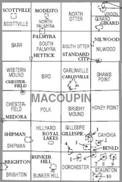
Townships
Macoupin County is divided into twenty-six townshipsCivil township
A civil township is a widely used unit of local government in the United States, subordinate to, and geographic divisions of, a county. Specific responsibilities and the degree of autonomy vary based on each state. Civil townships are distinct from survey townships, but in states that have both,...
:
|-valign="top"
|
- BarrBarr Township, Macoupin County, IllinoisBarr Township is located in Macoupin County, Illinois, USA. The population was 351 at the 2000 census.- External links :***...
- BirdBird Township, Macoupin County, IllinoisBird Township is located in Macoupin County, Illinois, USA. The population was 279 at the 2000 census.- External links :***...
- BrightonBrighton Township, Macoupin County, IllinoisBrighton Township is located in Macoupin County, Illinois, USA. The population was 4,149 at the 2000 census.- External links :***...
- Brushy MoundBrushy Mound Township, Macoupin County, IllinoisBrushy Mound Township is located in Macoupin County, Illinois, USA. The population was 751 at the 2000 census.- External links :***...
- Bunker HillBunker Hill Township, Macoupin County, IllinoisBunker Hill Township is located in Macoupin County, Illinois, USA. The population was 3,352 at the 2000 census.- External links :***...
- CahokiaCahokia Township, Macoupin County, IllinoisCahokia Township is located in Macoupin County, Illinois, USA. The population was 3,389 at the 2000 census.- External links :***...
- CarlinvilleCarlinville Township, Macoupin County, IllinoisCarlinville Township is located in Macoupin County, Illinois, USA. The population was 6,910 at the 2000 census.- External links :***...
|
- ChesterfieldChesterfield Township, Macoupin County, IllinoisChesterfield Township is located in Macoupin County, Illinois, USA. The population was 943 at the 2000 census.- External links :***...
- DorchesterDorchester Township, Macoupin County, IllinoisDorchester Township is located in Macoupin County, Illinois, USA. The population was 1,546 at the 2000 census.- External links :***...
- GillespieGillespie Township, Macoupin County, IllinoisGillespie Township is located in Macoupin County, Illinois, USA. The population was 4,114 at the 2000 census.- External links :***...
- GirardGirard Township, Macoupin County, IllinoisGirard Township is located in Macoupin County, Illinois, USA. The population was 2,582 at the 2000 census.- External links :***...
- HillyardHillyard Township, Macoupin County, IllinoisHillyard Township is located in Macoupin County, Illinois, USA. The population was 733 at the 2000 census.- External links :***...
- Honey PointHoney Point Township, Macoupin County, IllinoisHoney Point Township is located in Macoupin County, Illinois, USA. The population was 225 at the 2000 census.- External links :***...
- Mt. OliveMt. Olive Township, Macoupin County, IllinoisMt. Olive Township is located in Macoupin County, Illinois, USA. The population was 3,379 at the 2000 census.- External links :***...
|
- NilwoodNilwood Township, Macoupin County, IllinoisNilwood Township is located in Macoupin County, Illinois, USA. The population was 699 at the 2000 census.- External links :***...
- North OtterNorth Otter Township, Macoupin County, IllinoisNorth Otter Township is located in Macoupin County, Illinois, USA. The population was 840 at the 2000 census.- External links :***...
- North PalmyraNorth Palmyra Township, Macoupin County, IllinoisNorth Palmyra Township is located in Macoupin County, Illinois, USA. The population was 974 at the 2000 census.- External links :***...
- PolkPolk Township, Macoupin County, IllinoisPolk Township is located in Macoupin County, Illinois, USA. The population was 514 at the 2000 census.- External links :***...
- ScottvilleScottville Township, Macoupin County, IllinoisScottville Township is located in Macoupin County, Illinois, USA. The population was 356 at the 2000 census.- External links :***...
- Shaws PointShaws Point Township, Macoupin County, IllinoisShaws Point Township is located in Macoupin County, Illinois, USA. The population was 490 at the 2000 census.- External links :***...
|
- ShipmanShipman Township, Macoupin County, IllinoisShipman Township is located in Macoupin County, Illinois, USA. The population was 1,507 at the 2000 census.- External links :***...
- South OtterSouth Otter Township, Macoupin County, IllinoisSouth Otter Township is located in Macoupin County, Illinois, USA. The population was 395 at the 2000 census.- External links :***...
- South PalmyraSouth Palmyra Township, Macoupin County, IllinoisSouth Palmyra Township is located in Macoupin County, Illinois, USA. The population was 819 at the 2000 census.- External links :***...
- StauntonStaunton Township, Macoupin County, IllinoisStaunton Township is located in Macoupin County, Illinois, USA. The population was 5,731 at the 2000 census.- External links :***...
- VirdenVirden Township, Macoupin County, IllinoisVirden Township is located in Macoupin County, Illinois, USA. The population was 3,689 at the 2000 census.- External links :***...
- Western MoundWestern Mound Township, Macoupin County, IllinoisWestern Mound Township is located in Macoupin County, Illinois, USA. The population was 302 at the 2000 census.- External links :***...
|}
Climate and weather
In recent years, average temperatures in the county seat of Carlinville have ranged from a low of 17 °F (-8.3 °C) in January to a high of 87 °F (30.6 °C) in July, although a record low of -23 °F was recorded in February 1905 and a record high of 113 °F (45 °C) was recorded in July 1954. Average monthly precipitation ranged from 1.95 inches (5 cm) in February to 4.25 inches (10.8 cm) in May.See also
- National Register of Historic Places listings in Maucoupin County, Illinois